Rock climbing is a popular activity in the Peak District; particularly on edges such as Stanage or Froggatt. Generally the climbing style is free climbing and the rock is either gritstone or limestone. Climbing has been practised in the Peak District since the late 19th century; James W. Puttrell is generally credited with starting the sport. The first climbing guidebook to the area was Some Gritstone Climbs, by John Laycock, published in 1913. There are over 10,000 routes in the Peak District. One of the most famous Peak District climbers, and a pioneer of many new routes, is Ron Fawcett. The climb known as "Master's Edge", on Millstone Edge, near Hathersage, is a testament to his skill and strength. The climb is graded E7 6c and rises 19m up the near vertical edge.

Hathersage is a village and civil parish in the Peak District in Derbyshire, England. It lies slightly to the north of the River Derwent, approximately 10 miles (16.1 km) south-west of Sheffield.

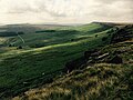
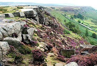
Froggatt Edge is a gritstone escarpment in the Dark Peak area of the Peak District National Park, in Derbyshire, England, close to the villages of Froggatt, Calver, Curbar, Baslow and Grindleford. The name Froggatt Edge applies only to the northernmost section of the escarpment; the middle and southernmost sections are called Curbar Edge and Baslow Edge respectively. The escarpment, like many in this area, is easily accessible from Sheffield.

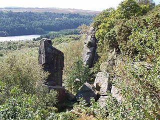
Master's Edge is an 18-metre (59 ft) gritstone arête that is a rock climbing route in the "Corners Area" of Millstone Edge quarry, in the Peak District, England. When English climber Ron Fawcett completed the first free ascent of the route on 29 December 1983, it was graded E7 6c, and one of the hardest traditional climbing routes in the world; it remains one of the hardest gritstone climbs.

Carl Wark is a rocky promontory on Hathersage Moor in the Peak District National Park, just inside the boundary of Sheffield, England. The promontory is faced by vertical cliffs on all but one side, which is protected by a prehistoric embankment. The cliffs and embankment form an enclosure that has been interpreted as an Iron Age hill fort, though the date of construction and purpose of the fortifications remains unknown. The site is a scheduled monument.

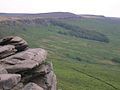
Derwent Edge is a Millstone Grit escarpment that lies above the Upper Derwent Valley in the Peak District National Park in the English county of Derbyshire. An Ordnance Survey column marks the highest point of the Edge at Back Tor. North of Back Tor the edge extends into Howden Edge and enters the county of South Yorkshire.

Blackstone Edge is a gritstone escarpment at 472 metres (1,549 ft) above sea level in the Pennine hills surrounded by moorland on the boundary between Greater Manchester and West Yorkshire in England.
Millstone Grit is the name given to any of a number of coarse-grained sandstones of Carboniferous age which occur in the British Isles. The name derives from its use in earlier times as a source of millstones for use principally in watermills. Geologists refer to the whole suite of rocks that encompass the individual limestone beds and the intervening mudstones as the Millstone Grit Group. The term Millstone Grit Series was formerly used to refer to the rocks now included within the Millstone Grit Group together with the underlying Edale Shale Group.
Rivelin Rocks are a gritstone edge or escarpment in the upper Rivelin Valley at grid reference SK279873, 9 kilometres (5.6 mi) west of Sheffield just off the A57 road in the county of South Yorkshire, England.
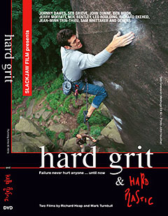
Hard Grit is a 1998 British rock climbing film directed by Richard Heap and produced by Slackjaw Film, featuring traditional climbing, free soloing, and bouldering on gritstone routes in the Peak District in Northern England. It is considered an important film in the genre and regarded as a historic and iconic film. The film starts with a dramatic fall by French climber Jean–Minh Trinh-Thieu on Gaia at Black Rocks. Hard Grit won ten international film festival awards.
Stanage or Stannage may refer to:

Stanedge Pole also known as Stanage Pole is a landmark on Hallam Moors close to Stanage Edge in South Yorkshire, England. Standing at a height of 438 metres, it marks the border between Derbyshire and South Yorkshire and can be seen for several miles around.
The Sheffield to Hathersage turnpike was an early road through the English Peak District, which was improved by a turnpike trust in the 18th century. The road may have originated as a Roman road.

Rivelin Dams are a pair of water storage reservoirs situated in the upper part of the Rivelin Valley, 5 miles (8 km) west of Sheffield in South Yorkshire, England. The dams are owned by Yorkshire Water and provide water to 319,000 people as well as compensation water for the River Rivelin. They are named Upper and Lower and fall just within the eastern boundary of the Peak District.
Some Gritstone Climbs is a rock climbing guidebook written by British lawyer John Laycock (1887–1960). The book's subtitle, included uniquely on the frontispiece, is Some Shorter Climbs . It was published in Manchester in 1913 by the Refuge Printing Department. Although focusing on rock climbing in the Peak District, it covers several adjacent cliffs outside this region, and despite its title, referring to the Millstone Grit geology of many of the cliffs, it includes several cliffs consisting of other rock types, including mountain limestone and red sandstone.

Long Causeway or Long Causey was a medieval packhorse route in England, which ran between Sheffield in South Yorkshire and Hathersage in Derbyshire. In the past the route has been marked on maps as a Roman Road as it was believed it followed part of the route of Batham Gate between Templeborough and Buxton, although in recent years some scholars have cast doubt on this.

Burbage Edge is a gritstone escarpment overlooking the Burbage district of Buxton in Derbyshire, in the Peak District. The hill's summit is 500 metres (1,600 ft) above sea level.

Harthill Moor is a small upland area in the Derbyshire Peak District of central and northern England, lying between Matlock and Bakewell near the villages of Birchover and Elton. The moor is within the southern portion of Harthill civil parish. Its highest point is 272 metres (892 ft) above sea level. The River Bradford flows along the northern edge of the moor past Youlgreave and into the River Lathkill at Alport. Harthill Moor is a rich prehistoric landscape with several protected Scheduled Ancient Monuments.
Curbar Edge is a gritstone moorland escarpment above the village of Curbar, in Derbyshire, England and close to the villages of Baslow, Calver, and Froggatt. It is located within the Peak District National Park at an altitude of 958 ft (292 m). It is regarded as a significant location for rock climbing, both regionally and nationally, in terms of both the historical development of the sport and as the location of first ascents.

Burbage Rocks is a gritstone escarpment in South Yorkshire, overlooking the village of Hathersage in the Peak District. The highest point along the escarpment is 429 metres (1,407 ft) above sea level, whilst Burbage Moor rises above to 438 metres (1,437 ft). Burbage Rocks is a southern extension of Stanage Edge. Burbage Brook runs from the northern end of the Burbage Rocks, past the southern end, through Padley Gorge and into the RIver Derwent.