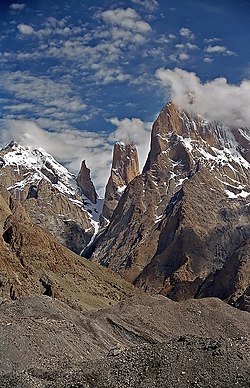
The White Cliffs of DoverThe Trango Towers in Pakistan. Their vertical faces are the world's tallest cliffs. Trango Tower center; Trango Monk center left; Trango II far left; Great Trango right.Europe's highest cliff, Troll Wall in Norway, a famous BASE jumping location for jumpers from around the world.
In geography and geology, a cliff or rock face is an area of rock which has a general angle defined by the vertical, or nearly vertical. Cliffs are formed by the processes of weathering and erosion, with the effect of gravity. Cliffs are common on coasts, in mountainous areas, escarpments and along rivers. Cliffs are usually composed of rock that is resistant to weathering and erosion. The sedimentary rocks that are most likely to form cliffs include sandstone, limestone, chalk, and dolomite. Igneous rocks such as granite and basalt also often form cliffs.
An escarpment (or scarp) is a type of cliff formed by the movement of a geologic fault, a landslide, or sometimes by rock slides or falling rocks which change the differential erosion of the rock layers.
Most cliffs have some form of scree slope at their base. In arid areas or under high cliffs, they are generally exposed jumbles of fallen rock. In areas of higher moisture, a soil slope may obscure the talus. Many cliffs also feature tributary waterfalls or rock shelters. Sometimes a cliff peters out at the end of a ridge, with mushroom rocks or other types of rock columns remaining. Coastal erosion may lead to the formation of sea cliffs along a receding coastline.
The British Ordnance Survey distinguishes between cliffs (continuous line along the topper edge with projections down the face) and outcrops (continuous lines along lower edge).
The far southwestern aspect of Nanga Parbat's Rupal face, highest cliff (rock wall/mountain face) in the world. The steepest part of the face is 2 km to the northeast. Cliffs are very common in areas where there are river banks and oceans.
Etymology
Cliff comes from the Old English word clif of essentially the same meaning, cognate with Dutch, Low German, and Old Norse klif 'cliff'.[1] These may in turn all be from a Romance loanword into Primitive Germanic that has its origins in the Latin forms clivus / clevus ("slope" or "hillside").[2][3]
Given that a cliff does not need to be exactly vertical, there can be ambiguity about whether a given slope is a cliff or not and also about how much of a certain slope to count as a cliff. For example, given a truly vertical rock wall above a very steep slope, one could count just the rock wall or the combination. Listings of cliffs are thus inherently uncertain.
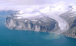
Some of the largest cliffs on Earth are found underwater. For example, an 8,000 m drop over a 4,250 m span can be found at a ridge sitting inside the Kermadec Trench. Or, some of the largest sea cliffs in the southern hemisphere exist both above (300 m) and below the waterline on the south-eastern edge of the island state of Tasmania, Australia: these are of the hard, igneous rock dolerite.
According to some sources, the highest cliff in the world, about 1,340 m high, is the east face of Great Trango in the Karakoram mountains of northern Pakistan. This uses a fairly stringent notion of cliff, as the 1,340 m figure refers to a nearly vertical headwall of two stacked pillars; adding in a very steep approach brings the total drop from the East Face precipice to the nearby Dunge Glacier to nearly 2,000 m.
The location of the world's highest sea cliffs depends also on the definition of 'cliff' that is used. Guinness World Records states it is Kalaupapa, Hawaii,[5] at 1,010 m high. Another contender is the north face of Mitre Peak, which drops 1,683 m to Milford Sound, New Zealand.[6] These are subject to a less stringent definition, as the average slope of these cliffs at Kaulapapa is about 1.7, corresponding to an angle of 60 degrees, and Mitre Peak is similar. A more vertical drop into the sea can be found at Maujit Qaqarssuasia (also known as the 'Thumbnail') which is situated in the Torssukátak fjord area at the very tip of South Greenland and drops 1,560 m near-vertically.[7]
Considering a truly vertical drop, Mount Thor on Baffin Island in Arctic Canada is often considered the highest at 1370m (4500ft) high in total (the top 480m (1600ft) is overhanging), and is said to give it the longest vertical drop on Earth at 1,250m (4,100ft). However, other cliffs on Baffin Island, such as Polar Sun Spire in the Sam Ford Fjord, or others in remote areas of Greenland may be higher.
Table Mountain, Cape Town, Western Cape, South Africa, 1,086m (3,563ft) above Atlantic Ocean
Above Land
Innumerable peaks in the Drakensberg mountains of South Africa are considered cliff formations. The Drakensberg Range is regarded, together with Ethiopia's Simien Mountains, as one of the two finest erosional mountain ranges on Earth. Because of their near-unique geological formation, the range has an extraordinarily high percentage of cliff faces making up its length, particularly along the highest portion of the range.[citation needed] This portion of the range is virtually uninterrupted cliff faces, ranging from 600m (2,000ft) to 1,200m (3,900ft) in height for almost 250km (160mi). Of all, the "Drakensberg Amphitheatre" (mentioned above) is most well known.[citation needed] Other notable cliffs include the Trojan Wall, Cleft Peak, Injisuthi Triplets, Cathedral Peak, Monk's Cowl, Mnweni Buttress, etc. The cliff faces of the Blyde River Canyon, technically still part of the Drakensberg, may be over 800m (2,600ft), with the main face of the Swadini Buttress approximately 1,000m (3,300ft) tall.
Drakensberg Amphitheatre, South Africa 1,200m (3,900ft) above base, 5km (3.1mi) long. The Tugela Falls, the world's second tallest waterfall, falls 948m (3,110ft) over the edge of the cliff face.
Several big granite faces in the Arctic region vie for the title of 'highest vertical drop on Earth', but reliable measurements are not always available. The possible contenders include (measurements are approximate):
Mount Thor, Baffin Island, Canada; 1,370m (4,500ft) total; top 480m (1600ft) is overhanging. This is commonly regarded as being the largest vertical drop on Earth [2][citation needed]ot:leapyear at 1,250m (4,100ft).
of Baffin Island, rises 4,300ft above the flat frozen fjord, although the lower portion of the face breaks from the vertical wall with a series of ledges and buttresses.[8]
The west face of Notch Peak in the House Range of southwestern Utah, U.S.; a carbonate rock pure vertical drop of about 670m (2,200ft), with 4,450 feet (1,356m) from the top of the cliff to valley floor (bottom of the canyon below the notch)
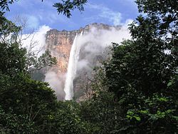
All faces of Auyan Tepui, along with all other Tepuis, Venezuela, Brazil, and Guyana, Auyan Tepui is about 1,000 m (location of Angel Falls) (the falls are 979 m, the highest in the world)
All faces of Cerro Chalten (Fitz Roy), Patagonia, Argentina-Chile, 1200 m
Qingshui Cliff, Xiulin Township, Hualien County, Taiwan averaging 800 m above Pacific Ocean. The tallest peak, Qingshui Mountain, rises 2408 m directly from the Pacific Ocean.
Qingshui Cliff, Xiulin Township, Hualien County, Taiwan averaging 800 m above Pacific Ocean. The tallest peak, Qingshui Mountain, rises 2408 meters directly from the Pacific Ocean.
Shispare Sar southwest face, Karakoram, Gilgit–Baltistan, Pakistan, 3,200 m
Spantik northwest face, Karakoram, Gilgit–Baltistan, Pakistan, 2,000 m
Trango Towers: East Face Great Trango Tower, Baltoro Muztagh, Gilgit–Baltistan, Pakistan, 1,340 m (near vertical headwall), 2,100 m (very steep overall drop from East Summit to Dunge Glacier). Northwest Face drops approximately 2,200 m to the Trango Glacier below, but with a taller slab topped out with a shorter overhanging headwall of approximately 1,000 m. The Southwest "Azeem" Ridge forms the group's tallest steep rise of roughly 2,286m (7,500ft) from the Trango Glacier to the Southwest summit.
Cliff landforms provide unique habitat niches to a variety of plants and animals, whose preferences and needs are suited by the vertical geometry of this landform type. For example, a number of birds have decided affinities for choosing cliff locations for nesting,[21] often driven by the defensibility of these locations as well as absence of certain predators. Humans have also inhabited cliff dwellings.
Flora
The population of the rareBorderea chouardii, during 2012, existed only on two cliff habitats within western Europe.[22]
↑Max Pfister: Altromanische Relikte in der östlichen und südlichen Galloromania, in den rheinischen Mundarten, im Alpenraum und in Oberitalien. In: Sieglinde Heinz, Ulrich Wandruszka [ed.]: Fakten und Theorien: Beitr. zur roman. u. allg. Sprachwiss.; Festschr. für Helmut Stimm zum 65. Geburtstag, Tübingen 1982, pp. 219 – 230, ISBN3-87808-936-8
↑Jon Roberts: Agdlerussakasit (1750 m), east face, new route on east face; The Butler (900 m) and Mark (900 m), first ascents. American Alpine Journal (AAJ) 2004, pp.266–267
This page is based on this Wikipedia article Text is available under the CC BY-SA 4.0 license; additional terms may apply. Images, videos and audio are available under their respective licenses.