Beaches in estuaries and bays

Last updated
A BEB adjacent to Crissy Field, San Francisco, facing the Golden Gate Bridge and Marin Headlands. Golden gate bridge from crissy field.jpg
A BEB adjacent to Crissy Field, San Francisco, facing the Golden Gate Bridge and Marin Headlands.

Beaches in estuaries and bays (BEBs) refer to beaches that exist inside estuaries or bays and therefore are partially or fully sheltered from ocean wind waves, [1] [2] which are a typical source of energy to build beaches. Beaches located inside harbours and lagoons are also considered BEBs. BEBs can be unvegetated or partially unvegetated and can be made of sand, gravel or shells. [3] As a consequence of the sheltering, the importance of other sources of wave energy, including locally generated wind waves and infragravity waves, may be more important for BEBs than for those beaches on the open coast. Boat wakes, [4] currents driven by tides, and river inflow can also be important for BEBs. When BEBs receive insufficient wave energy, they can become inactive, and stabilised by vegetation; this may occur through both natural processes and human action. [5] BEBs exist in all latitudes from beaches located in fjords and drowned river valleys (rias) in high latitudes to beaches located in the equatorial zone like, for example, the Amazon estuarine beaches. [6]

Contents

Importance

BEBs are found all around the world, including in large cities such as San Francisco, Sydney, Lisbon, London and Shanghai for example. While sometimes relatively small by area, they can provide a large range of resources. In addition to their ecological importance, BEBs can provide spaces in urban-settings for people to connect with nature, and protection for landward areas and infrastructure.

Ecological importance

BEBs provide critical habitats and feeding areas for local fish and birds. [7] Even small patches of sand can provide critical habitat. [8] Many BEBs are fronted by sea grass [9] and may allow marshes to develop behind them. [10] BEBs in estuaries are the habitat for Horseshoe crabs, which during spawning, if combined with moderate wave heights, modify the beach profile such as it becomes concave, similar to a storm profile and lowering the wave‐energy threshold for morphological response. [11] Studies in Jamaica Bay showed that the ecological restoration of Horseshoe crabs was limited by the extent of the beach instead of the water quality. [8] Studies of the Ichthyofauna of low energy BEBs in Southern Brazil showed their dependance on salinity and energy. [12]

Social importance

BEBs are often small and isolated and not as iconic as open-ocean beaches in popular culture; and may have a history of litter, [13] pollution and dereliction. [3] However, BEBs are often located around major cities and provide an important recreational and cultural resource. BEBs provide calm swimming opportunities for young children. [14] They can be immensely popular, like the beaches in the Pará River (Amazon Coast of Brazil) [15] or in Sydney Harbour, [16] [17] or little-known, as are some in San Francisco Bay. [18]

Coastal protection

BEBs provide protective buffers for wetlands and coastal development [3] [7] and it is important to protect them. The seagrass that often fronts these systems in Australia is endangered and ecological restoration projects such as Operation Posidonia [19] are in place to restore this seagrass. Other coastal protections placed in estuaries, like oyster reefs, are believed to attenuate erosive waves [20] and therefore protect the adjacent BEBs, [21] however, living reefs can create undesired coastal changes related to interrupting sediment transport pathways and excessive wave attenuation. [22]

Characteristics

BEBs, like all beaches, are accumulations of unconsolidated sediment (i.e., sand) within the cross-shore limits of wave action [23] and occur where there is a suitable supply of sediment and exposure to waves that are energetic enough to move sediment and overcome stabilization by vegetation. [5] The underlying geology is a primary control for the shape, volume and stability of BEBs, and the location and orientation of the beach inside the estuary or bay are important controls on its morphodynamic equilibrium. [24] The hydrodynamic processes (i.e., waves and currents) that control the shape and equilibrium of BEBs are largely determined by the geometric configuration of the estuary/bay; this includes the width and orientation of the entrance and the width, length and depth of the estuary/bay. For example, tidal currents are strong at constrictions like at the mouth of bar-built estuaries; estuaries or bays with wide mouths allow propagation of ocean waves; and, the existence of a large enough wind fetch within an estuary or bay allows the development of locally-generated wind waves. However, BEBs primarily exist in fetch-limited conditions, causing the geologic and biologic factors on beach shape to have outsize importance. [7]

Typical gradients from the entrance to the inner estuary or bay are observed:

Other social factors like population and nearby infrastructure control the degree to which a beach is affected by boat wakes and engineering works that can change the geometry of the bay. In fact, most bays and estuaries hosting large cities are strongly modified, for example, San Francisco, Shanghai, Sydney, or London.

BEBs can be controlled by different types of wave energy depending on their location inside the estuary/bay and the geometric configuration of the estuary/bay. The morphology and characteristics of BEBs vary broadly depending on geology, sediment availability and hydrodynamic energy. They can be narrow and low and exist under low-energy conditions or they can be directly exposed to swell waves propagating into the estuary, in which case they might resemble a beach on the open coast, but still be controlled by different processes. They can occur in all tidal conditions, from micro- to macro-tides, and under strong river flows to no river flow.

Other terms used for BEBs

BEBs may be low energy, sheltered, fetch-limited, lagoonal, backbarrier, and elsewhere, therefore, they have been noted in the literature with very different names. Here are a few examples:

Erosion & recovery

When BEBs are exposed to waves larger than the dominant conditions, they undergo erosion. The volume of erosion can be smaller than the volumes eroded from open-coast beaches, but they might represent a large percentage of the total volume of the beach. The destination of the sand eroded from the beach is not clear, in some cases the sand can be lost to tidal channels or stored in the flood-tide delta. [37] [28] In any case, recovery is slow and the sediment transport pathways and mechanisms of recovery are mostly unknown. It has been reported that the recovery of BEBs is slower than the recovery of open-coast beaches. [31] [38]

Related Research Articles

<span class="mw-page-title-main">Coast</span> Area where land meets the sea or ocean

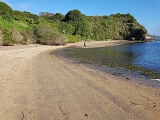
The coast, also known as the coastline or seashore, is defined as the area where land meets the ocean, or as a line that forms the boundary between the land and the coastline. Shores are influenced by the topography of the surrounding landscape, as well as by water induced erosion, such as waves. The geological composition of rock and soil dictates the type of shore which is created. The Earth has around 620,000 kilometres (390,000 mi) of coastline. Coasts are important zones in natural ecosystems, often home to a wide range of biodiversity. On land, they harbor important ecosystems such as freshwater or estuarine wetlands, which are important for bird populations and other terrestrial animals. In wave-protected areas they harbor saltmarshes, mangroves or seagrasses, all of which can provide nursery habitat for finfish, shellfish, and other aquatic species. Rocky shores are usually found along exposed coasts and provide habitat for a wide range of sessile animals and various kinds of seaweeds. In physical oceanography, a shore is the wider fringe that is geologically modified by the action of the body of water past and present, while the beach is at the edge of the shore, representing the intertidal zone where there is one. Along tropical coasts with clear, nutrient-poor water, coral reefs can often be found between depths of 1–50 meters.

<span class="mw-page-title-main">Estuary</span> Partially enclosed coastal body of brackish water

An estuary is a partially enclosed coastal body of brackish water with one or more rivers or streams flowing into it, and with a free connection to the open sea. Estuaries form a transition zone between river environments and maritime environments and are an example of an ecotone. Estuaries are subject both to marine influences such as tides, waves, and the influx of saline water, and to fluvial influences such as flows of freshwater and sediment. The mixing of seawater and freshwater provides high levels of nutrients both in the water column and in sediment, making estuaries among the most productive natural habitats in the world.

<span class="mw-page-title-main">Coastal erosion</span> Displacement of land along the coastline

Coastal erosion is the loss or displacement of land, or the long-term removal of sediment and rocks along the coastline due to the action of waves, currents, tides, wind-driven water, waterborne ice, or other impacts of storms. The landward retreat of the shoreline can be measured and described over a temporal scale of tides, seasons, and other short-term cyclic processes. Coastal erosion may be caused by hydraulic action, abrasion, impact and corrosion by wind and water, and other forces, natural or unnatural.

<span class="mw-page-title-main">Salt marsh</span> Coastal ecosystem between land and open saltwater that is regularly flooded

A salt marsh, saltmarsh or salting, also known as a coastal salt marsh or a tidal marsh, is a coastal ecosystem in the upper coastal intertidal zone between land and open saltwater or brackish water that is regularly flooded by the tides. It is dominated by dense stands of salt-tolerant plants such as herbs, grasses, or low shrubs. These plants are terrestrial in origin and are essential to the stability of the salt marsh in trapping and binding sediments. Salt marshes play a large role in the aquatic food web and the delivery of nutrients to coastal waters. They also support terrestrial animals and provide coastal protection.

<span class="mw-page-title-main">Longshore drift</span> Sediment moved by the longshore current

Longshore drift from longshore current is a geological process that consists of the transportation of sediments along a coast parallel to the shoreline, which is dependent on the angle of incoming wave direction. Oblique incoming wind squeezes water along the coast, and so generates a water current which moves parallel to the coast. Longshore drift is simply the sediment moved by the longshore current. This current and sediment movement occur within the surf zone. The process is also known as littoral drift.

<span class="mw-page-title-main">Barrier island</span> Coastal dune landform that forms by wave and tidal action parallel to the mainland coast

Barrier islands are a coastal landforms—a type of dune system and sand island—where an area of sand has been formed by wave and tidal action parallel to the mainland coast. They usually occur in chains, consisting of anything from a few islands to more than a dozen. They are subject to change during storms and other action, but absorb energy and protect the coastlines and create areas of protected waters where wetlands may flourish. A barrier chain may extend for hundreds of kilometers, with islands periodically separated by tidal inlets. The largest barrier island in the world is Padre Island of Texas, United States, at 113 miles (182 km) long. Sometimes an important inlet may close permanently, transforming an island into a peninsula, thus creating a barrier peninsula, often including a beach, barrier beach. Though many are long and narrow, the length and width of barriers and overall morphology of barrier coasts are related to parameters including tidal range, wave energy, sediment supply, sea-level trends, and basement controls. The amount of vegetation on the barrier has a large impact on the height and evolution of the island.

<span class="mw-page-title-main">Inlet</span> Indentation of a shoreline

An inlet is a indentation of a shoreline, such as a small arm, bay, sound, fjord, lagoon or marsh, that leads to an enclosed larger body of water such as a lake, estuary, gulf or marginal sea.

<span class="mw-page-title-main">Coos Bay</span>

Coos Bay is an estuary where the Coos River enters the Pacific Ocean, the estuary is approximately 12 miles long and up to two miles wide. It is the largest estuary completely within Oregon state lines. The Coos Bay watershed covers an area of about 600 square miles and is located in northern Coos County, Oregon in the United States. The Coos River, which begins in the Oregon Coast Range, enters the bay from the east. From Coos River, the bay forms a sharp loop northward before arching back to the south and out to the Pacific Ocean. Haynes Inlet enters the top of this loop. South Slough branches off from the bay directly before its entrance into the Pacific Ocean. The bay was formed when sea levels rose over 20,000 years ago at the end of the Last Glacial Maximum, flooding the mouth of the Coos River. Coos Bay is Oregon's most important coastal industrial center and international shipping port, with close ties to San Francisco, the Columbia River, Puget Sound and other major ports of the Pacific rim.

<span class="mw-page-title-main">Beach nourishment</span> Sediment replacement process

Beach nourishment describes a process by which sediment, usually sand, lost through longshore drift or erosion is replaced from other sources. A wider beach can reduce storm damage to coastal structures by dissipating energy across the surf zone, protecting upland structures and infrastructure from storm surges, tsunamis and unusually high tides. Beach nourishment is typically part of a larger integrated coastal zone management aimed at coastal defense. Nourishment is typically a repetitive process since it does not remove the physical forces that cause erosion but simply mitigates their effects.

<span class="mw-page-title-main">Tidal marsh</span> Marsh subject to tidal change in water

A tidal marsh is a marsh found along rivers, coasts and estuaries which floods and drains by the tidal movement of the adjacent estuary, sea or ocean. Tidal marshes experience many overlapping persistent cycles, including diurnal and semi-diurnal tides, day-night temperature fluctuations, spring-neap tides, seasonal vegetation growth and decay, upland runoff, decadal climate variations, and centennial to millennial trends in sea level and climate.

Coastal morphodynamics refers to the study of the interaction and adjustment of the seafloor topography and fluid hydrodynamic processes, seafloor morphologies and sequences of change dynamics involving the motion of sediment. Hydrodynamic processes include those of waves, tides and wind-induced currents.

<span class="mw-page-title-main">Coastal geography</span> Study of the region between the ocean and the land

Coastal geography is the study of the constantly changing region between the ocean and the land, incorporating both the physical geography and the human geography of the coast. It includes understanding coastal weathering processes, particularly wave action, sediment movement and weather, and the ways in which humans interact with the coast.

<span class="mw-page-title-main">Coastal management</span> Preventing flooding and erosion of shorelines

Coastal management is defence against flooding and erosion, and techniques that stop erosion to claim lands. Protection against rising sea levels in the 21st century is crucial, as sea level rise accelerates due to climate change. Changes in sea level damage beaches and coastal systems are expected to rise at an increasing rate, causing coastal sediments to be disturbed by tidal energy.

<span class="mw-page-title-main">Yaquina Bay</span> Small bay partially within Newport, Oregon, United States

Yaquina Bay is a coastal estuarine community found in Newport, Oregon. Yaquina Bay is a semi-enclosed body of water, approximately 8 km² (3.2 mi²) in area, with free connection to the Pacific Ocean, but also diluted with freshwater from the Yaquina River land drainage. The Bay is traversed by the Yaquina Bay Bridge.

Hard engineering involves the construction of hydraulic structures to protect coasts from erosion. Such structures include seawalls, gabions, breakwaters, groynes and tetrapods.

<span class="mw-page-title-main">Sedimentary budget</span>

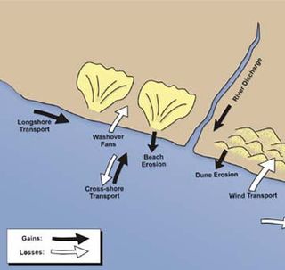
Sedimentary budgets are a coastal management tool used to analyze and describe the different sediment inputs (sources) and outputs (sinks) on the coasts, which is used to predict morphological change in any particular coastline over time. Within a coastal environment the rate of change of sediment is dependent on the amount of sediment brought into the system versus the amount of sediment that leaves the system. These inputs and outputs of sediment then equate to the total balance of the system and more than often reflect the amounts of erosion or accretion affecting the morphology of the coast.

<span class="mw-page-title-main">Coastal engineering</span> Branch of civil engineering

Coastal engineering is a branch of civil engineering concerned with the specific demands posed by constructing at or near the coast, as well as the development of the coast itself.

A mouth bar is an element of a deltaic system, which refers to the typically mid-channel deposition of the sediment transported by the river channel at the river mouth.

<span class="mw-page-title-main">Marine habitat</span> Habitat that supports marine life

A marine habitat is a habitat that supports marine life. Marine life depends in some way on the saltwater that is in the sea. A habitat is an ecological or environmental area inhabited by one or more living species. The marine environment supports many kinds of these habitats.

<span class="mw-page-title-main">Hapua</span>

A hapua is a river-mouth lagoon on a mixed sand and gravel (MSG) beach, formed at the river-coast interface where a typically braided, although sometimes meandering, river interacts with a coastal environment that is significantly affected by longshore drift. The lagoons which form on the MSG coastlines are common on the east coast of the South Island of New Zealand and have long been referred to as hapua by the Māori. This classification differentiates hapua from similar lagoons located on the New Zealand coast termed waituna.

References

  1. Bird, Eric (2008). "Estuaries and lagoons". Coastal geomorphology: An introduction. pp. 295–330. ISBN   978-0-470-51729-1.
  2. Vila-Concejo, Ana; Gallop, Shari L.; Largier, John L. (2020). "Sandy beaches in estuaries and bays". Sandy Beach Morphodynamics. pp. 343–362. doi:10.1016/B978-0-08-102927-5.00015-1. ISBN   9780081029275. S2CID   219882241.
  3. 1 2 3 4 5 6 Nordstrom, K.F. (1992). Estuarine Beaches: An introduction to the physical and human factors affecting use and management of beaches in estuaries, lagoons, bays and fjords. Essex: Elsevier Science Publishers.
  4. Bilkovic, D.; Mitchell, M.; Davis, J.; Andrews, E.; King, A.; Mason, P.; Herman, J.; Tahvildari, N.; Davis, J. (2017). Review of boat wake wave impacts on shoreline erosion and potential solutions for the Chesapeake Bay (Report). Edgewater, MD.
  5. 1 2 3 Freire, Paula; Jackson, Nancy L.; Nordstrom, Karl F. (2013). "Defining beaches and their evolutionary states in estuaries". Journal of Coastal Research. 65: 482–487. doi:10.2112/SI65-082.1. S2CID   131696849.
  6. Sousa, Rosigleyse Corrêa de; Pereira, Luci Cajueiro Carneiro; Costa, Rauquírio Marinho da; Jiménez, José A. (2017-04-01). "Management of estuarine beaches on the Amazon coast though the application of recreational carrying capacity indices". Tourism Management. 59: 216–225. doi:10.1016/j.tourman.2016.07.006. hdl: 2117/100987 . ISSN   0261-5177.
  7. 1 2 3 4 Nordstrom, Karl F.; Jackson, Nancy L. (2012). "Physical processes and landforms on beaches in short fetch environments in estuaries, small lakes and reservoirs: A review". Earth-Science Reviews. 111 (1–2): 232–247. Bibcode:2012ESRv..111..232N. doi:10.1016/j.earscirev.2011.12.004.
  8. 1 2 Botton, Mark L.; Loveland, Robert E.; Tanacredi, John T.; Itow, Tomio (2006). "Horseshoe crabs (Limulus polyphemus) in an urban estuary (Jamaica Bay, New York) and the potential for ecological restoration". Estuaries and Coasts. 29 (5): 820–830. doi:10.1007/BF02786533. S2CID   85075672.
  9. Simeone, Simons.; De Muro, Sandra; De Falco, Giovanni (2013). "Seagrass berm deposition on a Mediterranean embayed beach". Estuarine, Coastal and Shelf Science. 135: 171–181. Bibcode:2013ECSS..135..171S. doi:10.1016/j.ecss.2013.10.007.
  10. Portnoy, J.W.; Nowicki, B.L.; Roman, C.T.; Urish, D.W. (1998). "The discharge of nitrate‐contaminated groundwater from developed shoreline to marsh‐fringed estuary". Water Resources Research. 34 (11): 3095–3104. Bibcode:1998WRR....34.3095P. doi: 10.1029/98WR02167 .
  11. Jackson, Nancy L.; Nordstrom, Karl F.; Smith, David R. (2005). "Influence of waves and horseshoe crab spawning on beach morphology and sediment grain-size characteristics on a sandy estuarine beach". Sedimentology. 52 (5): 1097–1108. Bibcode:2005Sedim..52.1097J. doi:10.1111/j.1365-3091.2005.00725.x. ISSN   1365-3091. S2CID   35595227.
  12. Hackradt, Carlos Werner; Félix-Hackradt, Fabiana Cézar; Pichler, Helen Audrey; Spach, Henry Louis; Santos, Lilyane de Oliveira e (September 2011). "Factors influencing spatial patterns of the ichthyofauna of low energy estuarine beaches in southern Brazil". Journal of the Marine Biological Association of the United Kingdom. 91 (6): 1345–1357. doi:10.1017/S0025315410001682. ISSN   1469-7769. S2CID   85993789.
  13. "Coronavirus: How California's Coastal Cleanup Day is different this year: No crowds, but volunteers are still needed to clean beaches, creeks and lakes". www.mercurynews.com/. 2020-09-18. Retrieved 2020-12-10.
  14. Largier, J.L.; Taggart, M. Improving water quality at enclosed beaches. A report on the Enclosed Beach Symposium and Workshop (Clean Beaches Initiative) (Report). Bodega Bay.
  15. de Sousa-Felix, Rosigleyse Corrêa; Pereira, Luci Cajueiro Carneiro; Trindade, Wellington Nascimento; de Souza, Ingrid Padilha; da Costa, Rauquírio Marinho; Jimenez, José António (2017-11-15). "Application of the DPSIR framework to the evaluation of the recreational and environmental conditions on estuarine beaches of the Amazon coast". Ocean & Coastal Management. 149: 96–106. doi:10.1016/j.ocecoaman.2017.09.011. hdl: 2117/109073 . ISSN   0964-5691.
  16. "Secret Beaches in Sydney". www.sydney.com. Retrieved 2020-08-07.
  17. "Sydney Estuarine Beaches region". www.environment.nsw.gov.au. Retrieved 2020-10-14.
  18. "Little-known East Bay beach set for restoration". www.eastbaytimes.com. 19 August 2020. Retrieved 2020-12-18.
  19. "Posidonia Australis Project". Posidonia Australis Project. Retrieved 2020-08-07.
  20. Scyphers, Steven B.; Powers, Sean P.; Heck, Kenneth L. Jr.; Byron, Dorothy (2011-08-05). "Oyster Reefs as Natural Breakwaters Mitigate Shoreline Loss and Facilitate Fisheries". PLOS ONE. 6 (8): e22396. Bibcode:2011PLoSO...622396S. doi: 10.1371/journal.pone.0022396 . ISSN   1932-6203. PMC   3151262 . PMID   21850223.
  21. Currin, C. A.; Chappell, W. S.; Deaton, A. (2010), Shipman, Hugh; Dethier, Megan N.; Gelfenbaum, Guy; Fresh, Kurt L. (eds.), "Developing alternative shoreline armoring strategies: the living shoreline approach in North Carolina", Puget Sound shorelines and the impacts of armoring—proceedings of a state of the science workshop, May 2009, Reston, VA: U.S. Geological Survey, vol. 2010, pp. 91–102, retrieved 2020-08-07
  22. Pilkey, Orrin H.; Young, Rob; Longo, Norma; Coburn, Andy (March 1, 2012). "Rethinking Living Shorelines" (PDF). oyster-restoration.org. Archived (PDF) from the original on 2021-04-20.
  23. Short, A.D. (1999). Handbook of Beach and Shoreface Morphodynamics. Wiley.
  24. "Estuarine Beaches of the Bay". www.vims.edu. Archived from the original on 11 July 2018.
  25. 1 2 3 4 Jackson, Nancy L.; Nordstrom, Karl F.; Eliot, Ian; Masselink, Gerdhard (2002). "'Low energy' sandy beaches in marine and estuarine environments: A review". Geomorphology. 48 (1–3): 147–162. Bibcode:2002Geomo..48..147J. doi:10.1016/S0169-555X(02)00179-4.
  26. Jackson, Nancy L.; Nordstrom, Karl F. (1992). "Site Specific Controls on Wind and Wave Processes and Beach Mobility on Estuarine Beaches in New Jersey, U.S.A". Journal of Coastal Research. 8 (1): 88–98. JSTOR   4297955.
  27. 1 2 Harris, Daniel L.; Vila-Concejo, Ana; Austin, Timothy; Benavente, Javier (2020). "Multi-scale morphodynamics of an estuarine beach adjacent to a flood-tide delta: Assessing decadal scale erosion". Estuarine, Coastal and Shelf Science. 241: 106759. Bibcode:2020ECSS..24106759H. doi:10.1016/j.ecss.2020.106759. S2CID   219036419.
  28. 1 2 3 Vila-Concejo, Ana; Hughes, Michael G.; Short, Andrew D.; Ranasinghe, Roshanka (2010). "Estuarine shoreline processes in a dynamic low-energy system". Ocean Dynamics. 60 (2): 285–298. Bibcode:2010OcDyn..60..285V. doi:10.1007/s10236-010-0273-7. S2CID   131209461.
  29. McHugh, Paul (2001-01-10). "Winter Currents Eroding Beach At Crissy Field / GGNRA showplace threatened by high tides, surging storm swells". San Francisco. Retrieved 2020-12-09.
  30. Alejo, I; Costas, S; Vila-Concejo, A (2005). "Littoral evolution as a response to human action: the case of two sedimentary systems in a Galician Ria". J. Coast. Res. (SI 49): 64–69.
  31. 1 2 3 Costas, Susana; Alejo, Irene; Vila-Concejo, Ana; Nombela, Miguel A. (2005). "Persistence of storm-induced morphology on a modal low-energy beach: A case study from NW-Iberian Peninsula". Marine Geology. 224 (1–4): 43–56. Bibcode:2005MGeol.224...43C. doi:10.1016/j.margeo.2005.08.003.
  32. Freire, P.; Ferreira, Ó.; Taborda, R.; Oliveira, F.; Carrasco, A.R.; Vargas, C.; Capitão, R.; Fortes, C.; Coli, A.; Santos, J. (2009). "Morphodynamics of Fetch-Limited Beaches in Contrasting Environments". J. Coast. Res.: 183–187.
  33. Hegge, B.; Eliot, I.G.; Hsu, J. (1996). "Sheltered Sandy Beaches of Southwestern Australia". J. Coast. Res. 12: 748–760.
  34. Travers, A.; Eliot, M. J.; Eliot, I. G.; Jendrzejczak, M. (2010). "Sheltered sandy beaches of southwestern Australia". Geological Society, London, Special Publications. 346 (1): 23–42. Bibcode:2010GSLSP.346...23T. doi:10.1144/sp346.3. S2CID   62890669.
  35. Short, Andrew D. (2006). "Australian Beach Systems—Nature and Distribution". Journal of Coastal Research. 221: 11–27. doi:10.2112/05a-0002.1. S2CID   140148596.
  36. Short, A.D.; Woodroffe, C.D. (2009). The Coast of Australia. Cambridge University Press.
  37. Austin, Timothy; Vila-Concejo, Ana; Short, Andrew; Ranasinghe, Roshanka (2018). "A Multi-Scale Conceptual Model of Flood-Tide Delta Morphodynamics in Micro-Tidal Estuaries". Geosciences. 8 (9): 324. Bibcode:2018Geosc...8..324A. doi: 10.3390/geosciences8090324 .
  38. Nordstrom, Karl F. (1980). "Cyclic and Seasonal Beach Response: A Comparison of Oceanside and Bayside Beaches". Physical Geography. 1 (2): 177–196. doi:10.1080/02723646.1980.10642199.