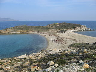
A lagoon is a shallow body of water separated from a larger body of water by barrier islands or reefs. Lagoons are commonly divided into coastal lagoons and atoll lagoons. They have also been identified as occurring on mixed-sand and gravel coastlines. There is an overlap between bodies of water classified as coastal lagoons and bodies of water classified as estuaries. Lagoons are common coastal features around many parts of the world.
A tombolo, from the Italian tombolo, derived from the Latin tumulus, meaning 'mound', and sometimes translated as ayre, is a deposition landform in which an island is attached to the mainland by a narrow piece of land such as a spit or bar. Once attached, the island is then known as a tied island. A tombolo is a sandy isthmus.
Both headland and bay are two coastal features that are related and often found on the same coastline. A bay is a body of water—usually seawater and sometimes fresh water— mostly surrounded by land, whereas a headland is surrounded by water on three sides. Headlands are characterized by breaking waves, rocky shores, intense erosion and steep sea cliffs. Bays generally have less wave activity and typically have sandy beaches. Headlands and bays form on discordant coastlines, where the land consists of bands of rock of alternating resistance that run perpendicular to the coast.

A spit or sandspit is a deposition bar or beach landform off coasts or lake shores. It develops in places where re-entrance occurs, such as at a cove's headlands, by the process of longshore drift by longshore currents. The drift occurs due to waves meeting the beach at an oblique angle, moving sediment down the beach in a zigzag pattern. This is complemented by longshore currents, which further transport sediment through the water alongside the beach. These currents are caused by the same waves that cause the drift.
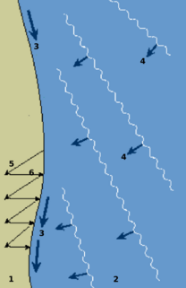
Longshore drift from longshore current is a geological process that consists of the transportation of sediments along a coast parallel to the shoreline, which is dependent on oblique incoming wind direction. Oblique incoming wind squeezes water along the coast, and so generates a water current which moves parallel to the coast. Longshore drift is simply the sediment moved by the longshore current. This current and sediment movement occur within the surf zone.

Barrier islands are coastal landforms and a type of dune system that are exceptionally flat or lumpy areas of sand that form by wave and tidal action parallel to the mainland coast. They usually occur in chains, consisting of anything from a few islands to more than a dozen. They are subject to change during storms and other action, but absorb energy and protect the coastlines and create areas of protected waters where wetlands may flourish. A barrier chain may extend uninterrupted for over a hundred kilometers, excepting the tidal inlets that separate the islands, the longest and widest being Padre Island of Texas. The length and width of barriers and overall morphology of barrier coasts are related to parameters including tidal range, wave energy, sediment supply, sea-level trends, and basement controls. The amount of vegetation on the barrier has a large impact on the height and evolution of the island.

A raised beach, coastal terrace, or perched coastline is a relatively flat, horizontal or gently inclined surface of marine origin, mostly an old abrasion platform which has been lifted out of the sphere of wave activity. Thus, it lies above or under the current sea level, depending on the time of its formation. It is bounded by a steeper ascending slope on the landward side and a steeper descending slope on the seaward side. Due to its generally flat shape it is often used for anthropogenic structures such as settlements and infrastructure.

Breakwaters are structures constructed near the coasts as part of coastal management or to protect an anchorage from the effects of both weather and longshore drift.

The Kaikoura Peninsula is located in the northeast of New Zealand's South Island. It protrudes five kilometres into the Pacific Ocean. The town of Kaikoura is located on the north shore of the peninsula. The peninsula has been settled by Maori for approximately 1000 years, and by Europeans since the 1800s, when whaling operations began off the Kaikoura Coast. Since the end of whaling in 1922 whales have been allowed to thrive and the region is now a popular whale watching destination.

St. Margarets Bay is a bay located on the Atlantic coast of Nova Scotia, Canada on the border of Halifax County and Lunenburg County.

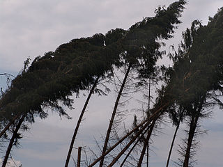
Coastal geography is the study of the constantly changing region between the ocean and the land, incorporating both the physical geography and the human geography of the coast. It includes understanding coastal weathering processes, particularly wave action, sediment movement and weather, and the ways in which humans interact with the coast
The shoreline is where the land meets the sea and it is continually changing. Over the long term, the water is eroding the land. Beaches represent a special case, in that they exist where sand accumulated from the same processes that strip away rocky and sedimentary material. That is, they can grow as well as erode. River deltas are another exception, in that silt that erodes up river can accrete at the river's outlet and extend ocean shorelines. Catastrophic events such as tsunamis, hurricanes and storm surges accelerate beach erosion, potentially carrying away the entire sand load. Human activities can be as catastrophic as hurricanes, albeit usually over a longer time interval.
A headland is a coastal landform, a point of land usually high and often with a sheer drop, that extends into a body of water. It is a type of promontory. A headland of considerable size often is called a cape. Headlands are characterised by high, breaking waves, rocky shores, intense erosion, and steep sea cliffs.
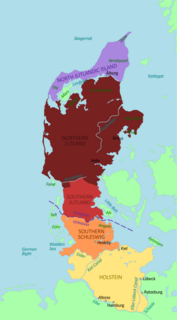
Jutland, also known as the Cimbric or Cimbrian Peninsula, is a peninsula of Northern Europe that forms the continental portion of Denmark and part of northern Germany. The names are derived from the Jutes and the Cimbri, respectively.

A cliffed coast, also called an abrasion coast, is a form of coast where the action of marine waves has formed steep cliffs that may or may not be precipitous. It contrasts with a flat or alluvial coast.

South Island is an island located in the Australian state of South Australia at the south end of Pondalowie Bay on the south-west extremity of Yorke Peninsula about 11 kilometres north-west by west of the town of Stenhouse Bay. The island has enjoyed protected area status since 1970 and since 1977, it has been part of the Innes National Park.

The coastline of Djursland in Denmark is 260 kilometers long as measured from the ferry berth in Voer in the middle of Randers Fjord ending at Avlsgård in Aarhus Bay to the south. There are 18 sandy beaches for swimming along the coastline according to the folder, Kystkort Djursland published by the peninsula's two municipalities, Norddjurs and Syddjurs. These beaches cover 15 – 20%. of the total coastline. The remaining 200 plus kilometres are mostly unspoiled coastal nature.