Natural arch

Last updated
Delicate Arch in Arches National Park, Utah, United States Delicate Arch LaSalle.jpg
Delicate Arch in Arches National Park, Utah, United States
The Great Arch, Tabuk Province, Saudi Arabia The Great Arch Saudi Arabia.jpg
The Great Arch, Tabuk Province, Saudi Arabia

A natural arch, natural bridge, or (less commonly) rock arch is a natural landform where an arch has formed with an opening underneath. Natural arches commonly form where inland cliffs, coastal cliffs, fins or stacks are subject to erosion from the sea, rivers or weathering (subaerial processes).

Contents

Most natural arches are formed from narrow fins and sea stacks composed of sandstone or limestone with steep, often vertical, cliff faces. The formations become narrower due to erosion over geologic time scales. The softer rock stratum erodes away creating rock shelters, or alcoves, on opposite sides of the formation beneath the relatively harder stratum, or caprock, above it. The alcoves erode further into the formation eventually meeting underneath the harder caprock layer, thus creating an arch. The erosional processes exploit weaknesses in the softer rock layers making cracks larger and removing material more quickly than the caprock; however, the caprock itself continues to erode after an arch has formed, which will ultimately lead to collapse.

The choice between bridge and arch is somewhat arbitrary. The Natural Arch and Bridge Society identifies a bridge as a subtype of arch that is primarily water-formed. [1] By contrast, the Dictionary of Geological Terms defines a natural bridge as a "natural arch that spans a valley of erosion." [2]

The largest natural arch, by a significant margin, is the Xianren Bridge in China, with a span of 122 ± 5 meters (400 ± 15 ft). [3]

Coastline

The Azure Window, Malta, which collapsed in 2017 Malta Gozo, Azure Window (10264176345).jpg
The Azure Window, Malta, which collapsed in 2017

On coasts two different types of arches can form depending on the geology. On discordant coastlines rock types run at 90° to the coast. Wave refraction concentrates the wave energy on the headland, and an arch forms when caves break through the headland. Two examples of this type of arch are London Bridge in Victoria, Australia, and Neill Island in the Andaman Islands, India. When these arches eventually collapse, they form stacks and stumps. On concordant coastlines rock types run parallel to the coastline, with weak rock such as shale protected by stronger rock such as limestone. The wave action along concordant coastlines breaks through the strong rock and then erodes the weak rock very quickly. Good examples of this type of arch are the Durdle Door and Stair Hole near Lulworth Cove on Dorset's Jurassic Coast in south England. When Stair Hole eventually collapses it will form a cove.

Weather-eroded arches

Metate Arch, Devils Garden (GSENM), a very thin arch near the end of its life Metate Arch, Devils Garden, Grand Staircase-Escalante National Monument, Utah, USA.jpg
Metate Arch, Devils Garden (GSENM), a very thin arch near the end of its life

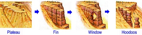
Weather-eroded arches begin their formation as deep cracks which penetrate into a sandstone layer. Erosion occurring within the cracks wears away exposed rock layers and enlarges the surface cracks isolating narrow sandstone walls which are called fins. Alternating frosts and thawing cause crumbling and flaking of the porous sandstone and eventually cut through some of the fins. The resulting holes become enlarged to arch proportions by rockfalls and weathering. The arches eventually collapse leaving only buttresses that in time will erode. [4]

Many weather-eroded arches are found in Arches National Park, Canyonlands National Park, and Grand Staircase–Escalante National Monument (GSENM), all located in southern Utah, United States.

Hoodoo formation-Big.jpg
Progressive erosion producing plateau, fin, window (or arch), and hoodoos

Water-eroded arches

A topographic map of Coyote Natural Bridge in Utah shows how the meandering Coyote Gulch carved a shorter route through the rock under the arch. The old riverbed is now higher than the present water level. Coyote Natural Bridge map.jpg
A topographic map of Coyote Natural Bridge in Utah shows how the meandering Coyote Gulch carved a shorter route through the rock under the arch. The old riverbed is now higher than the present water level.

Some natural bridges may look like arches, but they form in the path of streams that wear away and penetrate the rock. Pothole arches form by chemical weathering as water collects in natural depressions and eventually cuts through to the layer below.

Natural Bridges National Monument in Utah protects the area surrounding three large natural bridges, all of which were formed by streams running through canyons, the largest of which is named Sipapu Bridge with a span of 225 feet (69 m). The Rainbow Bridge National Monument's namesake was also formed by flowing water which created the largest known natural bridge in the Western Hemisphere with a span of 234 feet (71 m), based on a laser measurement made in 2007. Xianren Bridge, also known as Fairy Bridge, in Guangxi, China is currently the world's largest known natural bridge with a span recorded at 400 feet (120 m) by the Natural Arch and Bridge Society in October 2010, with a precision of ±15 feet (4.6 m). [5] [6]

Cave erosion

Natural bridges can form from natural limestone caves, where paired sinkholes collapse and a ridge of stone is left standing in between, with the cave passageway connecting from sinkhole to sinkhole.

Like all rock formations, natural bridges are subject to continued erosion, and will eventually collapse and disappear. One example of this was the double-arched Victorian coastal rock formation, London Bridge, which lost an arch after storms increased erosion. [7]

Moon Hill in Yangshuo, Guizhou Province, China, is an example of an arch formed by the remnant of a karst limestone cave.

Arches as highway or railway bridges

Natural Bridge, Virginia Natural Bridge State Park (31044316221).jpg
Natural Bridge, Virginia

In a few places in the world, natural arches are utilized by humans as transportation bridges with highways or railroads running across them.

In Virginia, US Route 11 traverses Natural Bridge. Two additional natural arch roadways are found in Kentucky. The first, a cave erosion arch made of limestone, is in Carter Caves State Resort Park and has a paved road on top. [8] The second, a weather-eroded sandstone arch with a dirt road on top, is on the edge of Natural Bridge State Park in Kentucky. The latter arch is called White's Branch Arch (also known as the Narrows) and the road going over it is usually referred to as the Narrows Road.[ citation needed ]

In Europe, the Romanian village of Ponoarele has a road segment called God's Bridge that is 30 m (98 ft) long and 13 m (43 ft) wide, passing over a stone arch 22 m (72 ft) high and 9 m (30 ft) thick. [9]

The railroad from Lima, Peru crosses the Rio Yauli on a natural bridge near kilometer 214.2 as it approaches the city of La Oroya.[ citation needed ]

Notable natural arches

TadrartRouge3.jpg
Natural arches in the La Cathedrale formation of Tadrart Rouge range, Algeria
Hole In The Wall.jpg
Hole-in-the-Wall

Africa

Antarctica

Asia

Natural Arch, Tirumala, India Natural stone arch in tirumala.JPG
Natural Arch, Tirumala, India
Arch in Timna Valley Park, Negev Desert, Israel Arches in Timna Park in summer 2011 (7).JPG
Arch in Timna Valley Park, Negev Desert, Israel

Europe

The arches at Marinha Beach, Caramujeira, Lagoa, Algarve, Portugal Praia da Marinha (2012-09-27), by Klugschnacker in Wikipedia (31).JPG
The arches at Marinha Beach, Caramujeira, Lagoa, Algarve, Portugal
Es Pontas is a natural arch on the coast of Mallorca, Spain Es pontas 2.jpg
Es Pontàs is a natural arch on the coast of Mallorca, Spain
Durdle Door, Dorset, the United Kingdom Durdle Door Dorset Sunset.jpg
Durdle Door, Dorset, the United Kingdom

North America

Canada

Perce Rock, Quebec, Canada QC Gaspesie RocherPerce tango7174.jpg
Percé Rock, Quebec, Canada

Caribbean

Mexico

The Arch of Cabo San Lucas, Mexico CaboSanLucasLandsEnd.JPG
The Arch of Cabo San Lucas, Mexico

United States

Holei Sea Arch, Hawaii Volcanoes National Park, Hawaii, United States Hawaii Volcanoes National Park 02.jpg
Holei Sea Arch, Hawaii Volcanoes National Park, Hawaii, United States
Landscape Arch, Utah, United States - one of the longest natural arches in the world Landscape Arch Utah.jpg
Landscape Arch, Utah, United States – one of the longest natural arches in the world
Rainbow Bridge, Utah, a natural bridge formed by a meandering watercourse Utah Rainbow Arch.jpg
Rainbow Bridge, Utah, a natural bridge formed by a meandering watercourse

Oceania

"The Hole in the Rock" on Piercy Island, Cape Brett, New Zealand Hole in the Rock at Motukokako Island (Piercy Island).jpg
"The Hole in the Rock” on Piercy Island, Cape Brett, New Zealand
The arch at Tunnel Beach, Dunedin, New Zealand Rock arch south of Tunnel Beach.jpg
The arch at Tunnel Beach, Dunedin, New Zealand

Australia

New Zealand

South America

See also

Related Research Articles

<span class="mw-page-title-main">Landscape Arch</span> Natural rock arch in Arches National Park, Utah, US

Landscape Arch is a natural arch in Arches National Park, Utah, United States. It is among the longest natural rock arches in the world.

<span class="mw-page-title-main">Sinkhole</span> Geologically-formed topological depression

A sinkhole is a depression or hole in the ground caused by some form of collapse of the surface layer. The term is sometimes used to refer to doline, enclosed depressions that are locally also known as vrtače and shakeholes, and to openings where surface water enters into underground passages known as ponor, swallow hole or swallet. A cenote is a type of sinkhole that exposes groundwater underneath. Sink and stream sink are more general terms for sites that drain surface water, possibly by infiltration into sediment or crumbled rock.

<span class="mw-page-title-main">Stack (geology)</span> Geological landform consisting of a steep and often vertical column or columns of rock

A stack or sea stack is a geological landform consisting of a steep and often vertical column or columns of rock in the sea near a coast, formed by wave erosion. Stacks are formed over time by wind and water, processes of coastal geomorphology. They are formed when part of a headland is eroded by hydraulic action, which is the force of the sea or water crashing against the rock. The force of the water weakens cracks in the headland, causing them to later collapse, forming free-standing stacks and even a small island. Without the constant presence of water, stacks also form when a natural arch collapses under gravity, due to sub-aerial processes like wind erosion. Erosion causes the arch to collapse, leaving the pillar of hard rock standing away from the coast—the stack. Eventually, erosion will cause the stack to collapse, leaving a stump. Stacks can provide important nesting locations for seabirds, and many are popular for rock climbing.

Landforms are categorized by characteristic physical attributes such as their creating process, shape, elevation, slope, orientation, rock exposure, and soil type.

<span class="mw-page-title-main">Rainbow Bridge National Monument</span> Natural bridge in San Juan County, Utah, United States

Rainbow Bridge is a natural arch in southern Utah, United States. With a span of 275 feet (84 m), as reported in 1974 by the Bureau of Reclamation, and height of 290 feet (88 m), it is one of the largest natural arches in the world. At the top it is 42 feet (13 m) thick and 33 feet (10 m) wide. The bridge, which is of cultural importance to a number of area Native American tribes, has been designated a Traditional Cultural Property by the National Park Service. Rainbow Bridge National Monument was protected in 1910, and it is administered by Glen Canyon National Recreation Area.

<span class="mw-page-title-main">Mesa</span> Elevated area of land with a flat top and sides

A mesa is an isolated, flat-topped elevation, ridge or hill, which is bounded from all sides by steep escarpments and stands distinctly above a surrounding plain. Mesas characteristically consist of flat-lying soft sedimentary rocks capped by a more resistant layer or layers of harder rock, e.g. shales overlain by sandstones. The resistant layer acts as a caprock that forms the flat summit of a mesa. The caprock can consist of either sedimentary rocks such as sandstone and limestone; dissected lava flows; or a deeply eroded duricrust. Unlike plateau, whose usage does not imply horizontal layers of bedrock, e.g. Tibetan Plateau, the term mesa applies exclusively to the landforms built of flat-lying strata. Instead, flat-topped plateaus are specifically known as tablelands.

The exposed geology of the Bryce Canyon area in Utah shows a record of deposition that covers the last part of the Cretaceous Period and the first half of the Cenozoic era in that part of North America. The ancient depositional environment of the region around what is now Bryce Canyon National Park varied from the warm shallow sea in which the Dakota Sandstone and the Tropic Shale were deposited to the cool streams and lakes that contributed sediment to the colorful Claron Formation that dominates the park's amphitheaters.

<span class="mw-page-title-main">Double Arch (Utah)</span> Natural arch in Utah, United States

Double Arch is a close-set pair of natural arches in Arches National Park in southern Grand County, Utah, United States, that is one of the more known features of the park.

<span class="mw-page-title-main">Geology of the Capitol Reef area</span>

The exposed geology of the Capitol Reef area presents a record of mostly Mesozoic-aged sedimentation in an area of North America in and around Capitol Reef National Park, on the Colorado Plateau in southeastern Utah.

<span class="mw-page-title-main">Aloba Arch</span>

Aloba Arch is a natural arch located in Chad. Large natural arches are somewhat rare outside the southern and western regions of China and the Colorado Plateau of the southwest United States. Chad's Ennedi Plateau, located within the Sahara Desert in the northeast part of the country near Libya and Sudan has a geology similar to the Colorado Plateau and has produced a number of natural arches and similar landforms, although only Aloba can claim to be on the top ten list of longest arches in the world.

<span class="mw-page-title-main">Big South Fork National River and Recreation Area</span> Protected area in central northeast Tennessee and southeastern Kentucky, United States

The Big South Fork National River and Recreation Area, commonly known as Big South Fork, preserves the Big South Fork of the Cumberland River and its tributaries in northeastern Tennessee and southeastern Kentucky.

<span class="mw-page-title-main">Natural Bridge Park</span> Private park featuring a natural-arch rock formation.

Natural Bridge Park, near the town of Natural Bridge, Alabama, is a privately owned park in Winston County that has been open since 1954. The current owners are Donnie and Naomi Lowman.

<span class="mw-page-title-main">Azure Window</span> Former natural arch in Gozo, Malta

The Azure Window, also known as the Dwejra Window, was a 28-metre-tall (92 ft) natural arch on the island of Gozo, located just off the shores of Malta. The limestone feature, which was in Dwejra Bay close to the Inland Sea and Fungus Rock, was one of the island's major tourist attractions until it collapsed in stormy weather on 8 March 2017. The arch, together with other natural features in the area, has appeared in a number of international films and media productions.

<span class="mw-page-title-main">Devils Garden (Arches National Park)</span>

Devils Garden is an area of Arches National Park, located near Moab, Utah, United States, that features a series of rock fins and arches formed by erosion. The Devils Garden Trail, including more primitive sections and spurs, meanders through the area for 7.2 mi (11.6 km). The trailhead leads directly to Landscape Arch after a 0.8 mi (1.3 km) outbound hike, while Tunnel Arch and Pine Tree Arch can be seen on spur trails on the way to Landscape Arch. Several other arches, including Partition, Navajo, Double O, and Private Arch, as well as the Dark Angel monolith and Fin Canyon, are accessed via the primitive loop trail and its spurs.

<span class="mw-page-title-main">Arches National Park</span> National park in Utah, United States

Arches National Park is a national park in eastern Utah, United States. The park is adjacent to the Colorado River, 4 mi (6 km) north of Moab, Utah. The park contains more than 2,000 natural sandstone arches, including the well-known Delicate Arch, which constitute the highest density of natural arches in the world. It also contains a variety of other unique geological resources and formations. The national park lies above an underground evaporite layer or salt bed, which is the main cause of the formation of the arches, spires, balanced rocks, sandstone fins, and eroded monoliths in the area.

<span class="mw-page-title-main">Cedar Mesa Sandstone</span>

Cedar Mesa Sandstone is a sandstone member of the Cutler Formation, found in southeast Utah, southwest Colorado, northwest New Mexico, and northeast Arizona.

<span class="mw-page-title-main">Devils Garden (Grand Staircase–Escalante National Monument)</span>

The Devils Garden of the Grand Staircase–Escalante National Monument (GSENM) in south central Utah, United States, is a protected area featuring hoodoos, natural arches and other sandstone formations. The area is also known as the Devils Garden Outstanding Natural Area within the National Landscape Conservation System.

<span class="mw-page-title-main">Shinarump Conglomerate</span>

The Shinarump Conglomerate is a geologic formation found in the Four Corners region of the United States. It was deposited in the early part of the Late Triassic period.

A fin is a geological formation that is a narrow, residual wall of hard sedimentary rock that remains standing after surrounding rock has been eroded away along parallel joints or fractures. Fins are formed when a narrow butte or plateau develops many vertical, parallel cracks. There are two main modes of following erosion. The first is when water flows along joints and fractures and opens them wider and wider, eventually causing erosion. The second is where the rock type (stratum) is harder and more erosion resistant than neighboring rocks, causing the weaker rock to fall away.

<span class="mw-page-title-main">Cedar Sink</span>

Cedar Sink is a vertical-walled large depression, or sinkhole, in the ground, that is located in Edmonson County, Kentucky and contained within and managed by Mammoth Cave National Park. The sinkhole measures 300 feet (91.4 m) from the top sandstone plateau to the bottom of the sink and was caused by collapse of the surface soil. The landscape is karst topography, which means the region is influenced by the dissolution of soluble rocks. Sinkholes, caves, and dolines typically characterize these underground drainage systems. Cedar Sink has a bottom area of about 7 acres (2.8 ha) and has more fertile soil compared to the ridgetops.

References

  1. Natural Arch and Bridge Society Archived August 31, 2009, at the Wayback Machine , FAQ.
  2. American Geological Institute, Dictionary of Geological Terms, 1976, Doubleday Anchor
  3. Big 14 Tour - Fairy Bridge Archived April 20, 2017, at the Wayback Machine , The Natural Arch and Bridge Society
  4. "Geology Resources, Arches National Park". National Park Service. Archived from the original on December 23, 2015. Retrieved December 23, 2015.
  5. Jett, Stephen C.China Diary Archived December 29, 2013, at the Wayback Machine , The Natural Arch and Bridge Society
  6. "Big 17 Tour - Measurement of Fairy Bridge". www.naturalarches.org. Archived from the original on November 12, 2013.
  7. "Port Campbell". www.trekearth.com. Archived from the original on September 8, 2008.
  8. "Natural Bridge Trail: Carter Caves State Resort Park". Kentucky State Parks. Retrieved November 19, 2019.
  9. Ciortescu, Ramona (December 10, 2014). "'God's Bridge', the Natural Bridge of Mehedinti, Romania". Romania Journal. Retrieved November 19, 2019.
  10. "Kerguelen Islands, French Southern and Antarctic Lands (Part 1) - Iles Kerguelen, TAAF". www.discoverfrance.net. Archived from the original on January 17, 2012.
  11. Offbeat Tracks in Maharashtra - A Travel Guide - Book by Milind Gunaji ISBN   81-7154-669-2
  12. "Gallery - Thailand - White Hole". www.naturalarches.org. Archived from the original on March 4, 2017.
  13. "Mountain Angel Eye".
  14. 1 2 3 Ian Ellis, ed. (2011). Richard Ellis - The Photography Collection: Malta & Gozo. Vol. 4. p. 100. ISBN   978-99957-33-29-2. Archived from the original on April 30, 2016.
  15. The Natural Arch and Bridge Society. "Puentedei".
  16. "The Worlds Longest Natural Spans". www.naturalarches.org. Natural Arch and Bridge Society. Archived from the original on December 25, 2016. Retrieved January 10, 2017.
  17. "Koger Arch, Kentucky" Archived April 20, 2017, at the Wayback Machine . naturalarches.org. The Natural Arch and Bridge Society. Retrieved November 6, 2017.
  18. "Natural Arch". Kentucky Society of Professional Geologists. Archived from the original on December 23, 2015. Retrieved December 23, 2015.
  19. "Natural Arch of Kentucky" Archived April 19, 2017, at the Wayback Machine . naturalarches.org. The Natural Arch and Bridge Society. Retrieved November 6, 2017.
  20. "Natural Bridge | Arkansas.com". www.arkansas.com. Retrieved 2020-11-24.
  21. "Sea stack at Tettegouche toppled by powerful winter storm" 2019-12-02
  22. "Big South Fork National River and Recreation Area: Twin Arches". nps.gov. April 14, 2015. Retrieved March 14, 2018.