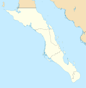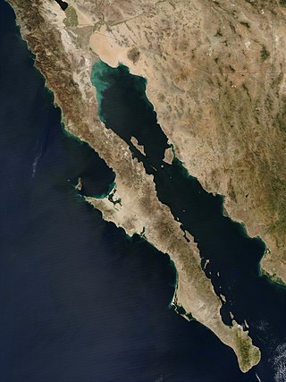
The Baja California peninsula is a peninsula in northwestern Mexico. It separates the Gulf of California from the Pacific Ocean. The peninsula extends from Mexicali, Baja California, in the north to Cabo San Lucas, Baja California Sur, in the south.

Baja California Sur, officially Estado Libre y Soberano de Baja California Sur, is the least populated state and the 31st admitted state of the 32 federal entities which comprise the 31 States of Mexico. It is also the ninth-largest Mexican state in terms of area.
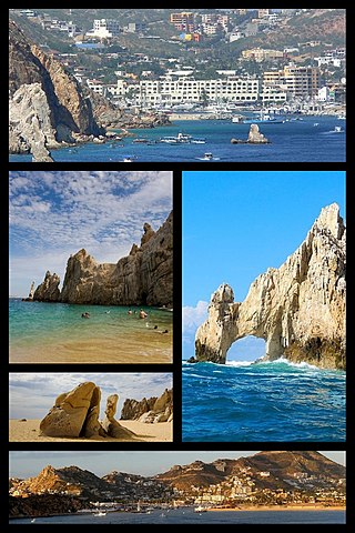
Cabo San Lucas, also known simply as Cabo, is a resort city at the southern tip of the Baja California peninsula, in the Mexican state of Baja California Sur. As of the 2020 Census, the population of the city was 202,694. Cabo San Lucas, together with the famous San José del Cabo are collectively known as Los Cabos. Together, they form a metropolitan area of 351,111 inhabitants.

San Quintín is a city in San Quintín Municipality, Baja California, located on the Pacific Coast of Mexico. The city had a population of 4777 in 2011. San Quintín is an important agricultural center for Baja California. The city is also an emerging tourist destination, known for its sand dunes and beaches.
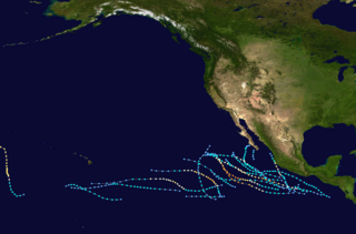
The 1987 Pacific hurricane season was the last year in which the Eastern Pacific Hurricane Center was the primary warning center for tropical cyclones in the eastern Pacific Ocean. The season officially started May 15, 1987, in the eastern Pacific, and June 1, 1987, in the central Pacific, and lasted until November 30, 1987. These dates conventionally delimit the period of each year when the vast majority of tropical cyclones form in the northeastern Pacific Ocean.

Los Cabos is a municipality located at the southern tip of Mexico's Baja California Peninsula, in the state of Baja California Sur. It encompasses the two towns of Cabo San Lucas and San José del Cabo linked by a thirty-two-km Resort Corridor of beach-front properties and championship golf courses.

Federal Highway 1 is a free (libre) part of the federal highway corridors of Mexico, and the highway follows the length of the Baja California Peninsula from Tijuana, Baja California, in the north to Cabo San Lucas, Baja California Sur, in the south. The road connects with Via Rapida, which merges into the American Interstate 5 (I-5) at the San Ysidro Port of Entry, which crosses the international border south of San Ysidro, California.
Mulegé is the northernmost municipality of the Mexican state of Baja California Sur. It is the largest municipality by area in Mexico, with an area of 33,092.20 km2. In the 2020 Census, it had a population of 64,022 inhabitants. Isla Natividad is part of the municipality.

The El Vizcaíno Biosphere Reserve, created in 1988, is located in Mulegé Municipality in northern Baja California Sur, at the center of the Baja California Peninsula between the Pacific Ocean and the Gulf of California. With an area of over 24,930 km2 (9,630 sq mi)), it is the largest wildlife refuge in Mexico and borders the northern edge of the Valle de los Cirios Protected Area of Flora and Fauna.

The Los Cabos Corridor is a tourist area located in the Los Cabos Municipality, Baja California Sur, Mexico. It sits on the southern coast of the Baja California Peninsula, facing the Gulf of California on the Transpeninsular Highway between San José del Cabo and Cabo San Lucas. It stretches about 30 km (19 mi) along the highway and addresses within this area are usually specified in terms of distances from the start of Highway 1. The corridor is considered a popular tourist destination as it has many beach resorts, golf courses, and sport fishing.

Hurricane Ignacio was the latest-forming first hurricane of a Pacific hurricane season since reliable satellite observation began in 1966. The ninth tropical storm of the 2003 Pacific hurricane season, Ignacio developed out of a tropical wave on August 22 a short distance off the coast of Mexico. It was initially predicted to track out to sea and remain a weak tropical storm, though it unexpectedly organized rapidly to attain peak winds of 105 mph (169 km/h) on August 24 while located a short distance southeast of southern Baja California Sur. Land interaction weakened Ignacio to an 80 mph (130 km/h) hurricane by the time it made landfall near La Paz, and it dissipated on August 27 in the central Baja California peninsula.
Federal Highway 1D is a tolled part of the Mexico Federal Highways, paralleling Fed. 1. There are two segments, one in the state of Baja California and another in the state of Baja California Sur.

Tropical Storm Georgette was a short-lived tropical storm that struck Baja California Sur in September 2010. Georgette originated from an area of disturbed weather over the eastern Pacific ocean on September 20. The next day, the system was upgraded into a tropical storm a short distance south of Baja California Sur. As the storm moved over the peninsula, it weakened to a tropical depression. It continued north and as such made landfall on mainland Mexico on September 22. Georgette dissipated early the next day while located inland over Sonora. Although officials noted the threat for heavy rainfall across northwest Mexico and Baja California, damage was minimal and no deaths were reported in the country. However, remnant moisture moved into New Mexico, producing flooding that killed one person.

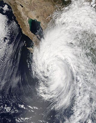
Hurricane Odile is tied for the most intense landfalling tropical cyclone in the Baja California Peninsula during the satellite era. Sweeping across the peninsula in September 2014, Odile inflicted widespread damage, particularly in the state of Baja California Sur, in addition to causing lesser impacts on the Mexican mainland and Southwestern United States. The precursor to Odile developed into a tropical depression south of Mexico on September 10 and quickly reached tropical storm strength. After meandering for several days, Odile began to track northwestward, intensifying to hurricane status before rapidly reaching its Category 4 hurricane peak intensity on September 14. The cyclone slightly weakened before making landfall near Cabo San Lucas with winds of 125 mph (205 km/h). Odile gradually weakened as it tracked across the length of the Baja California Peninsula, briefly crossing into the Gulf of California before degenerating into a remnant system on September 17. These remnants tracked northeastward across the Southwestern United States before they were no longer identifiable on September 19.
Hurricane Newton was the first tropical cyclone to make landfall on the Baja California Peninsula at hurricane strength since Hurricane Odile in 2014. The fifteenth tropical depression, fifteenth named storm and ninth hurricane of the 2016 Pacific hurricane season, Newton formed from a tropical wave to the south of Mexico on September 4, 2016. Moving northwards through an environment conducive for additional development, Newton rapidly strengthened, reaching hurricane strength on the following day. Newton made landfall on the Baja California Peninsula just below peak strength on the same day. Interaction with the mountainous terrain of the peninsula caused some slight weakening, but Newton remained a hurricane till it entered the Gulf of California. Increasing wind shear caused Newton to weaken at a faster pace, and the system made landfall in Sonora late on September 6 as a strong tropical storm. The cyclone continued to rapidly weaken over the rugged terrain of Sonora, and it degenerated into a remnant low just south of the Mexico–United States border on September 7. The remnants of Newton dissipated early on the following day.

Hurricane Bud was a Category 4 hurricane that brought winds and severe flooding to Mexico throughout its existence as a tropical cyclone in June 2018. It was the second named storm, hurricane, and major hurricane of the 2018 Pacific hurricane season. Bud originated from a tropical wave that departed from Western Africa on May 29. It traveled across the Atlantic Ocean before entering the Northeast Pacific Ocean late on June 6. The system moved towards the northwest and steadily organized, becoming a tropical depression on June 9 and Tropical Storm Bud early the next day. Favorable upper-level winds, ample moisture aloft, and warm sea surface temperatures allowed the storm to rapidly intensify to a hurricane late on June 10, and further to a major hurricane on the following day. Bud ultimately peaked the next morning with maximum sustained winds of 140 mph (230 km/h) and a minimum central pressure of 943 mbar. Its track curved more northward while the storm rapidly succumbed to the effects of upwelling. Bud made landfall on Baja California Sur as a minimal tropical storm early on June 15. On the next day, land interaction and increasing wind shear caused Bud to degenerate into a post-tropical cyclone. It opened up into a trough of low-pressure on June 16. The remnants of Bud moved towards the Southwestern United States, bringing tropical moisture and gusty winds to the region.

Hurricane Lorena was a strong Pacific hurricane in September 2019 that brought heavy rainfall, flooding, and mudslides to Southwestern Mexico and the Baja California Peninsula and also brought severe weather to the U.S. state of Arizona. Lorena was the thirteenth named storm and seventh and final hurricane of the 2019 Pacific hurricane season. A tropical wave, originally from the North Atlantic, entered the East Pacific basin on September 16. With increasing thunderstorm development, Lorena formed as a tropical storm on September 17 alongside Tropical Storm Mario. Lorena made its passage northwestward and quickly gained strength before it made landfall as a Category 1 hurricane in Jalisco on September 19. Due to interaction with the mountainous terrain, Lorena weakened back to a tropical storm. After moving into the warm ocean temperatures of the Gulf of California, however, Lorena re-strengthened into a hurricane, and reached its peak intensity with 1-minute sustained winds of 85 mph (137 km/h) and a minimum barometric pressure of 985 millibars (29.1 inHg) Lorena made a second landfall in the Mexican state of Baja California Sur, and quickly weakened thereafter. Lorena weakened to a tropical storm over the Gulf of California, and became a remnant low on September 22, shortly after making landfall in Sonora as a tropical depression. The remnant low moved inland over Mexico, and eventually dissipated inland over Arizona on September 24.