Bryce Canyon National Park is an American national park located in southwestern Utah. The major feature of the park is Bryce Canyon, which despite its name, is not a canyon, but a collection of giant natural amphitheaters along the eastern side of the Paunsaugunt Plateau. Bryce is distinctive due to geological structures called hoodoos, formed by frost weathering and stream erosion of the river and lake bed sedimentary rock. The red, orange, and white colors of the rocks provide spectacular views for park visitors. Bryce Canyon National Park is much smaller and sits at a much higher elevation than nearby Zion National Park. The rim at Bryce varies from 8,000 to 9,000 feet.

A natural arch, natural bridge, or rock arch is a natural landform where an arch has formed with an opening underneath. Natural arches commonly form where inland cliffs, coastal cliffs, fins or stacks are subject to erosion from the sea, rivers or weathering.
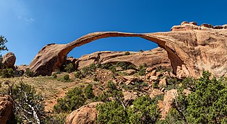
Landscape Arch is a natural arch in Arches National Park, Utah, United States. It is among the longest natural rock arches in the world.
Kolob Arch is a natural arch in Zion National Park, Utah, United States. According to the Natural Arch and Bridge Society (NABS), it is the sixth-longest natural arch in the world. In 2006, the Society measured the span at 287.4 ± 2 feet, which is slightly shorter than Landscape Arch in Arches National Park. Differences in measuring technique or definitions could produce slightly different results and change this ranking.

Natural Bridges National Monument is a U.S. National Monument located about 50 miles (80 km) northwest of the Four Corners boundary of southeast Utah, in the western United States, at the junction of White Canyon and Armstrong Canyon, part of the Colorado River drainage. It features the thirteenth largest natural bridge in the world, carved from the white Permian sandstone of the Cedar Mesa Formation that gives White Canyon its name.

Rainbow Bridge is a natural arch in southern Utah, United States. With a span of 275 feet (84 m), as reported in 1974 by the Bureau of Reclamation, and height of 290 feet (88 m), it is one of the largest natural arches in the world. At the top it is 42 feet (13 m) thick and 33 feet (10 m) wide. The bridge, which is of cultural importance to a number of area Native American tribes, has been designated a Traditional Cultural Property by the National Park Service. Rainbow Bridge National Monument was protected in 1910, and it is administered by Glen Canyon National Recreation Area.

The Colorado Plateau, also known as the Colorado Plateau Province, is a physiographic and desert region of the Intermontane Plateaus, roughly centered on the Four Corners region of the southwestern United States. This province covers an area of 336,700 km2 (130,000 mi2) within western Colorado, northwestern New Mexico, southern and eastern Utah, northern Arizona, and a tiny fraction in the extreme southeast of Nevada. About 90% of the area is drained by the Colorado River and its main tributaries: the Green, San Juan, and Little Colorado. Most of the remainder of the plateau is drained by the Rio Grande and its tributaries.

Double Arch is a close-set pair of natural arches in Arches National Park in southern Grand County, Utah, United States, that is one of the more known features of the park.

Wrather Arch is a cave type natural arch in the Paria Canyon-Vermilion Cliffs Wilderness, in Coconino County, northern Arizona. The sandstone arch is located in the eponymous Wrather Canyon, a short side canyon of Paria Canyon. The Paria River is a tributary of the Colorado River, at its confluence down−canyon at Lee's Ferry. Wrather Arch was first spotted by a local pilot from Page, Arizona, Royce K Knight, as he flew over a remote gorge west of Glen Canyon. Reaching the arch by helicopter in 1963, Knight and National Geographic staff man Walter M Edwards calculated its height as 165 feet and about 250 feet across. A news bulletin from National Geographic dated February 4, 1966 states, "Tall as a 15 story building, Wrather Arch ... The Taj Mahal would fit comfortably into the arch..."

Rattlesnake Canyon is a scenic area within the Black Ridge Canyons Wilderness which in turn forms the core of the Bureau of Land Management administered McInnis Canyons National Conservation Area in west central Colorado. The canyon contains nine natural arches, the second highest concentration of such arches in the United States, after the much better known Arches National Park.

White Canyon is a canyon in San Juan County, Utah, United States.

Navajo Mountain is a peak in San Juan County, Utah, with its southern flank extending into Coconino County, Arizona, in the United States. It holds an important place in the traditions of three local Native American tribes. The summit is the highest point on the Navajo Nation.

Interstate 70 (I-70) is a mainline route of the Interstate Highway System in the United States connecting Utah and Maryland. The Utah section runs east–west for approximately 232 miles (373 km) across the central part of the state. Richfield is the largest Utah city served by the freeway, which does not serve or connect any urban areas in the state. The freeway was built as part of a system of highways connecting Los Angeles and the Northeastern United States. I-70 was the second attempt to connect southern California to the east coast of the United States via central Utah, the first being a failed attempt to construct a transcontinental railroad. Parts of that effort were reused in the laying out of the route of I-70.

Arches National Park is a national park in eastern Utah, United States. The park is adjacent to the Colorado River, 4 mi (6 km) north of Moab, Utah. More than 2,000 natural sandstone arches are located in the park, including the well-known Delicate Arch, as well as a variety of unique geological resources and formations. The park contains the highest density of natural arches in the world.

The Corona Arch is a natural sandstone arch near Moab, Utah, in a side canyon of the Colorado River west of Moab in Grand County, Utah, United States. It can be accessed via a 1.5-mile (2.4 km) hiking trail from Utah State Route 279.

Morning Glory Natural Bridge is a large alcove arch located in Grandstaff Canyon near Moab, Utah.

Kachina Bridge is a large natural arch located in Natural Bridges National Monument near Blanding, Utah.
Owachomo Natural Bridge is a large alcove arch located in Natural Bridges National Monument near Blanding, Utah. It is the oldest and among the longest arches in the region.

Stevens Arch is a large natural arch located in Grand Staircase–Escalante National Monument, Utah. The bridge has a span of 220 feet, making it the fourteenth longest natural arch span in the United States as measured by the Natural Arch and Bridge Society.