A natural arch, natural bridge, or rock arch is a natural landform where an arch has formed with an opening underneath. Natural arches commonly form where inland cliffs, coastal cliffs, fins or stacks are subject to erosion from the sea, rivers or weathering.

Coastal erosion is the loss or displacement of land, or the long-term removal of sediment and rocks along the coastline due to the action of waves, currents, tides, wind-driven water, waterborne ice, or other impacts of storms. The landward retreat of the shoreline can be measured and described over a temporal scale of tides, seasons, and other short-term cyclic processes. Coastal erosion may be caused by hydraulic action, abrasion, impact and corrosion by wind and water, and other forces, natural or unnatural.
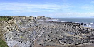
A wave-cut platform, shore platform, coastal bench, or wave-cut cliff is the narrow flat area often found at the base of a sea cliff or along the shoreline of a lake, bay, or sea that was created by erosion. Wave-cut platforms are often most obvious at low tide when they become visible as huge areas of flat rock. Sometimes the landward side of the platform is covered by sand, forming the beach, and then the platform can only be identified at low tides or when storms move the sand.

The intertidal zone or foreshore is the area above water level at low tide and underwater at high tide: in other words, the part of the littoral zone within the tidal range. This area can include several types of habitats with various species of life, such as seastars, sea urchins, and many species of coral with regional differences in biodiversity. Sometimes it is referred to as the littoral zone or seashore, although those can be defined as a wider region.
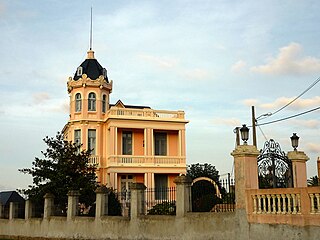
Sanxenxo is a municipality in Galicia, Spain in the province of Pontevedra.

The Cíes Islands are an archipelago off the coast of Pontevedra in Galicia, Spain, in the mouth of the Ria de Vigo. They were declared a Nature Reserve in 1980 and are included in the Atlantic Islands of Galicia National Park created in 2002.
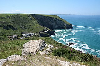
Bossiney Haven is a small cove in the civil parish of Tintagel. It is on the north coast of Cornwall, United Kingdom and a mile east of Tintagel and three miles west of Boscastle. The South West Coast Path closely follows the coast above the cove.
Barreiros is a municipality in the Spanish province of Lugo. This municipality is closely linked to the history of the province from pre-Roman times. It has a geographical range extending from the valleys to the mountains and from the plains to the coast with high cliffs and long beaches.
Trebarwith Strand is a section of coastline located near the coastal settlement of Trebarwith on the north coast of Cornwall, England, UK, 2+1⁄2 miles (4.0 km) south of Tintagel. It has 800m of sandy beach contained by cliffs in which natural caves are found. The beach can only be accessed at low tide. The strand was once used to land ships to export slate from the nearby quarries while sand from the beach was used for agricultural purposes. The view from the beach is dominated by rocks 300m offshore known as Gull Rock or Otterham Rocks.

Rías Altas is the northernmost of three sections of A Costa do Marisco in Galicia, Spain. It extends from the port of Ribadeo to Santa Cruz.

Blue Pool Bay is a small cove near the village of Llangennith in Gower, Wales. The cove is bordered by cliffs, and is accessible via a clifftop path and a steep, unstable path down to the beach. The beach is covered fully at high tide and takes its name from a large, natural rockpool. Rhossili Bay is nearby.

Ribadeo is a municipality in the Spanish province of Lugo in Galicia. It has a population of 10,023 and an area of 106.2 km2 (41.0 sq mi). It is the capital of the A Mariña Oriental comarca.

The beaches in Póvoa de Varzim are an extensive and continuous group of golden sandy beaches forming small bays or coves along the shoreline in northern Portugal. These do not have any barrier and are in fact a single beach, over 12 km long, under the name Praia da Póvoa de Varzim. Division may be arbitrary and serve localization porpoises.

Ses Balandres is a rocky cove with a very small beach on the western seaboard of the Spanish island of Ibiza. It is 1.2 miles (1.9 km) directly north of the village of Santa Agnès de Corona within the municipality of Sant Antoni de Portmany.

Praia do Vale dos Homens is a beach within the Municipality of Aljezur, in the Algarve, Portugal. The beach is on the western seaboard in the north west of the Algarve. The beach is 1.7 miles (2.7 km) north west of the village of Rogil, and is 72.4 miles (116.5 km) north west, by road, from the region's capital of Faro.

Praia da Amoreira is a beach within the Municipality of Aljezur, in the Algarve, Portugal. The beach is on the western Seaboard in the north west of the Algarve. The beach is 5.4 miles (8.7 km) north west of the village of Aljezur, and is 71.8 miles (115.6 km) north west, by road, from the regions capital of Faro.
Praia do Canal is a beach within the Municipality of Aljezur, in the Algarve, Portugal. The beach is on the western Seaboard in the north west of the Algarve. The beach is 6.7 miles (10.8 km) south west of the village of Aljezur, and is 65.6 miles (105.6 km) north west, by road, from the regions capital of Faro. The beach of Praia do Canal is inside the Vicentine Coast Natural Park, an area of outstanding natural beauty.

Praia do Penedo is a beach within the Municipality of Aljezur, in the Algarve, Portugal. The beach is on the western Seaboard in the north west of the Algarve. The beach is 6.7 miles (10.8 km) south west of the village of Aljezur, and is 65.6 miles (105.6 km) north west, by road, from the regions capital of Faro. The beach of Praia do Penedo is inside the Vicentine Coast Natural Park, an area of outstanding natural beauty.
Praia da Baía dos Tiros is a beach within the Municipality of Aljezur, in the Algarve, Portugal. The beach is on the western Seaboard in the extreme north-west of the Algarve. It is inside the Vicentine Coast Natural Park. The beach is 2.2 miles (3.5 km) north-west of the village of Maria Vinagre, and is 74.2 miles (119.4 km) north-west, by road, from the regions capital of Faro.

Praia da Oura is a blue flag beach within the Municipality of Albufeira, in the Algarve, Portugal. The beach is in the eastern district of Albufeira in the neighbourhood called Areias de São João. Its flanked by Praia dos Aveiros to the west and Praia de Santa Eulália to the eastern side. The beach is approximately 900 metres (3,000 ft) in length and is 450 metres (1,480 ft) wide at low tide.