Bryce Canyon National Park

Last updated

Bryce Canyon National Park
Inspiration Point Bryce Canyon November 2018 panorama.jpg
USA Utah relief location map.svg
Red pog.svg
Usa edcp relief location map.png
Red pog.svg
Location Garfield County and Kane County, Utah, United States
Nearest city Tropic, Panguitch
Coordinates 37°35′N112°11′W / 37.583°N 112.183°W / 37.583; -112.183
Area35,835 acres (145.02 km2) [1]
EstablishedFebruary 25, 1928
Visitors2,354,660(in 2022) [2]
Governing body National Park Service
Website Bryce Canyon National Park

Bryce Canyon National Park ( /brs/ ) is an American national park located in southwestern Utah. The major feature of the park is Bryce Canyon, which despite its name, is not a canyon, but a collection of giant natural amphitheaters along the eastern side of the Paunsaugunt Plateau. Bryce is distinctive due to geological structures called hoodoos, formed by frost weathering and stream erosion of the river and lake bed sedimentary rock. The red, orange, and white colors of the rocks provide spectacular views for park visitors. Bryce Canyon National Park is much smaller and sits at a much higher elevation than nearby Zion National Park. The rim at Bryce varies from 8,000 to 9,000 feet (2,400 to 2,700 m).

Contents

The Bryce Canyon area was settled by Mormon pioneers in the 1850s and was named after Ebenezer Bryce, who homesteaded in the area in 1874. [3] The area around Bryce Canyon was originally designated as a national monument by President Warren G. Harding in 1923 and was redesignated as a national park by Congress in 1928. The park covers 35,835 acres (55.992 sq mi; 14,502 ha; 145.02 km2) [1] and receives substantially fewer visitors than Zion National Park (nearly 4.3 million in 2016) or Grand Canyon National Park (almost 6 million in 2016), largely due to Bryce's more remote location. In 2018, Bryce Canyon received 2,679,478 recreational visitors, an increase of 107,794 visitors from the prior year. [2]

Geography

Bryce Canyon National Park lies within the Colorado Plateau geographic province of North America and straddles the southeastern edge of the Paunsaugunt Plateau west of the Paunsaugunt Faults (Paunsaugunt is Paiute for "home of the beaver"). [4] Park visitors arrive from the plateau part of the park and look over the plateau's edge toward a valley containing the fault and the Paria River just beyond it (Paria is Paiute for "muddy or elk water"). The edge of the Kaiparowits Plateau bounds the opposite side of the valley.

Bryce Canyon was not formed from erosion initiated from a central stream, meaning it technically is not a canyon. Instead headward erosion has excavated large amphitheater-shaped features in the Cenozoic-aged rocks of the Paunsaugunt Plateau. [4] This erosion resulted in delicate and colorful pinnacles called hoodoos that are up to 200 feet (60 m) high. A series of amphitheaters extends more than 20 miles (30 km) north-to-south within the park. [4] The largest is Bryce Amphitheater, which is 12 miles (19 km) long, 3 miles (5 km) wide and 800 feet (240 m) deep. [4] A nearby example of amphitheaters with hoodoos in the same formation but at a higher elevation is in Cedar Breaks National Monument, which is 25 miles (40 km) to the west on the Markagunt Plateau. [5]

Rainbow Point, the highest part of the park at 9,105 feet (2,775 m), [6] is at the end of the 18-mile (29 km) scenic drive. [4] From there, Aquarius Plateau, Bryce Amphitheater, the Henry Mountains, the Vermilion Cliffs and the White Cliffs can be seen. Yellow Creek, where it exits the park in the northeast section, is the lowest part of the park at 6,620 feet (2,020 m). [7]

Bryce Amphitheater from Sunrise Point Bryce Amphitheater from Sunrise Point Highres 2013.jpg
Bryce Amphitheater from Sunrise Point

Climate

According to the Köppen climate classification system, Bryce Canyon National Park has a continental climate with warm, dry summers (Dsb). Dsb climates are defined by their coldest month having an average mean temperature below 32 °F (0 °C), all months with an average mean temperature below 71.6 °F (22 °C), at least four months with an average mean temperature above 50 °F (10 °C), and three times as much precipitation in the wettest winter month compared to the driest summer month. The plant hardiness zone at the visitor center is 5b with an average annual extreme minimum air temperature of −10.0 °F (−23.3 °C). [8]

The national park is located in southwestern Utah about 50 miles (80 km) northeast of and 1,000 feet (300 m) higher than Zion National Park. [9] [5] The weather in Bryce Canyon is, therefore, cooler, and the park receives more precipitation: a total of 15 to 18 inches (380 to 460 mm) per year. [10] [7] Yearly temperatures vary from an average minimum of 9 °F (−13 °C) in January to an average maximum of 83 °F (28 °C) in July, but extreme temperatures can range from −30 to 97 °F (−34 to 36 °C). [7] The record high temperature in the park was 98 °F (37 °C) on July 14, 2002. The record low temperature was −26 °F (−32 °C) on February 6, 1989, and January 13, 1963.

Climate data for Bryce Canyon National Park Headquarters, Utah, 19912020 normals, extremes 1959present
MonthJanFebMarAprMayJunJulAugSepOctNovDecYear
Record high °F (°C)59
(15)
64
(18)
67
(19)
75
(24)
85
(29)
95
(35)
98
(37)
90
(32)
89
(32)
79
(26)
68
(20)
60
(16)
98
(37)
Mean maximum °F (°C)48.9
(9.4)
50.7
(10.4)
59.0
(15.0)
67.6
(19.8)
75.7
(24.3)
84.1
(28.9)
87.8
(31.0)
84.6
(29.2)
79.6
(26.4)
70.8
(21.6)
58.4
(14.7)
49.3
(9.6)
88.4
(31.3)
Mean daily maximum °F (°C)36.9
(2.7)
38.8
(3.8)
45.8
(7.7)
53.5
(11.9)
63.1
(17.3)
75.1
(23.9)
80.0
(26.7)
77.5
(25.3)
70.1
(21.2)
58.2
(14.6)
45.8
(7.7)
36.8
(2.7)
56.8
(13.8)
Daily mean °F (°C)26.9
(−2.8)
28.6
(−1.9)
34.5
(1.4)
41.2
(5.1)
49.9
(9.9)
59.8
(15.4)
66.0
(18.9)
63.7
(17.6)
55.9
(13.3)
45.0
(7.2)
34.3
(1.3)
26.9
(−2.8)
44.4
(6.9)
Mean daily minimum °F (°C)17.0
(−8.3)
18.4
(−7.6)
23.3
(−4.8)
28.9
(−1.7)
36.6
(2.6)
44.6
(7.0)
52.1
(11.2)
50.0
(10.0)
41.6
(5.3)
31.9
(−0.1)
22.8
(−5.1)
17.0
(−8.3)
32.0
(0.0)
Mean minimum °F (°C)−0.4
(−18.0)
1.1
(−17.2)
7.1
(−13.8)
15.5
(−9.2)
23.1
(−4.9)
31.0
(−0.6)
40.8
(4.9)
39.7
(4.3)
27.8
(−2.3)
18.4
(−7.6)
4.7
(−15.2)
−1.0
(−18.3)
−4.7
(−20.4)
Record low °F (°C)−26
(−32)
−26
(−32)
−11
(−24)
−3
(−19)
13
(−11)
21
(−6)
28
(−2)
23
(−5)
16
(−9)
0
(−18)
−12
(−24)
−23
(−31)
−26
(−32)
Average precipitation inches (mm)1.91
(49)
1.70
(43)
1.27
(32)
0.77
(20)
0.91
(23)
0.47
(12)
1.55
(39)
1.94
(49)
1.78
(45)
1.73
(44)
1.28
(33)
1.34
(34)
16.65
(423)
Average snowfall inches (cm)19.8
(50)
18.1
(46)
13.2
(34)
5.9
(15)
1.5
(3.8)
0.2
(0.51)
0.0
(0.0)
0.0
(0.0)
0.0
(0.0)
3.0
(7.6)
9.7
(25)
15.3
(39)
86.7
(220)
Average precipitation days (≥ 0.01 in)6.37.66.25.75.53.28.810.27.05.34.76.276.7
Average snowy days (≥ 0.1 in)6.37.25.53.31.20.10.00.00.01.33.45.734.0
Mean monthly sunshine hours 217.0226.0248.0300.0341.0360.0341.0310.0300.0279.0210.0186.03,318
Mean daily sunshine hours 7881011121110109769
Mean daily daylight hours 9.910.812.013.214.214.714.513.612.411.210.29.612.2
Percent possible sunshine 71746776778276748180696374
Average ultraviolet index 24681011111085327
Source 1: NOAA [11] [12]
Source 2: Weather Atlas (sun data) [13]

History

Native American habitation

Little is known about early human habitation in the Bryce Canyon area. Archaeological surveys of Bryce Canyon National Park and the Paunsaugunt Plateau show that people have been in the area for at least 10,000 years. Basketmaker Anasazi artifacts several thousand years old have been found south of the park. Other artifacts from the Pueblo-period Anasazi and the Fremont culture (up to the mid-12th century) have also been found. [14]

The Paiute Native Americans moved into the surrounding valleys and plateaus in the area around the same time that the other cultures left. [14] These Native Americans hunted and gathered for most of their food, but also supplemented their diet with some cultivated products. The Paiute in the area developed a mythology surrounding the hoodoos (pinnacles) in Bryce Canyon. They believed that hoodoos were the Legend People whom the trickster Coyote turned to stone. [15] At least one older Paiute said his culture called the hoodoos Anka-ku-was-a-wits, which is Paiute for "red painted faces". [14]

European American exploration and settlement

Ebenezer Bryce and his family lived in this cabin below Bryce Amphitheater (c. 1881). Bryce Cabin circa 1881.jpg
Ebenezer Bryce and his family lived in this cabin below Bryce Amphitheater (c.1881).

It was not until the late 18th and early 19th century that the first European Americans explored the remote and hard-to-reach area. [14] Mormon scouts visited the area in the 1850s to gauge its potential for agricultural development, use for grazing, and settlement. [14]

The first major scientific expedition to the area was led by U.S. Army Major John Wesley Powell in 1872. [14] Powell, along with a team of mapmakers and geologists, surveyed the Sevier and Virgin River area as part of a larger survey of the Colorado Plateaus. His mapmakers kept many of the Paiute place names. [4]

Small groups of Mormon pioneers followed and attempted to settle east of Bryce Canyon along the Paria River. In 1873, the Kanarra Cattle Company started to use the area for cattle grazing. [14]

The Church of Jesus Christ of Latter-day Saints sent Scottish immigrant Ebenezer Bryce and his wife Mary to settle land in the Paria Valley because they thought his carpentry skills would be useful in the area. The Bryce family chose to live right below Bryce Amphitheater—the main collection of hoodoos in the park. Bryce grazed his cattle inside what are now park borders, and reputedly thought that the amphitheaters were a "helluva place to lose a cow." [3] He also built a road to the plateau to retrieve firewood and timber, and a canal to irrigate his crops and water his animals. Other settlers soon started to call the unusual place "Bryce's Canyon", which was later formalized into Bryce Canyon.

A combination of drought, overgrazing, and flooding eventually drove the remaining Paiutes from the area and prompted the settlers to attempt construction of a water diversion channel from the Sevier River drainage. When that effort failed, most of the settlers, including the Bryce family, left the area. [4] Bryce moved his family to Arizona in 1880. [7] The remaining settlers dug a 10-mile (16 km) ditch from the Sevier's east fork into Tropic Valley. [4]

Creation of the park

Bryce Canyon Lodge was built between 1924 and 1925 from local materials. Bryce Canyon Lodge.jpg
Bryce Canyon Lodge was built between 1924 and 1925 from local materials.

These scenic areas were first described to the public in magazine articles published by Union Pacific and Santa Fe railroads in 1916. [3] People like Forest Supervisor J. W. Humphrey promoted the scenic wonders of Bryce Canyon's amphitheaters, and by 1918 nationally distributed articles also helped to spark interest. [14] However, poor access to the remote area and the lack of accommodations kept visitation to a bare minimum.

Ruby Syrett, Harold Bowman, and the Perry brothers later built modest lodging and set up "touring services" in the area. [14] Syrett later served as the first postmaster of Bryce Canyon. Visitation steadily increased, and by the early 1920s, the Union Pacific Railroad became interested in expanding rail service into southwestern Utah to accommodate more tourists. [14]

Visitor center in winter Bryce Canyon visitors center.jpg
Visitor center in winter

At the same time, conservationists became alarmed by the damage overgrazing, logging, and unregulated visitation were having on the fragile features of Bryce Canyon. A movement to have the area protected was soon started, and National Park Service Director Stephen Mather responded by proposing that Bryce Canyon be made into a state park. However, the governor of Utah and the Utah State Legislature lobbied for national protection of the area. Mather relented and sent his recommendation to President Warren G. Harding, who on June 8, 1923, declared Bryce Canyon a national monument. [14]

A road was built the same year on the plateau to provide easy access to outlooks over the amphitheaters. From 1924 to 1925, Bryce Canyon Lodge was built from local timber and stone. [16]

Members of the United States Congress started work in 1924 on upgrading Bryce Canyon's protection status from a national monument to a national park to establish Utah National Park. [16] A process led by the Utah Parks Company for transferring ownership of private and state-held land in the monument to the federal government started in 1923. [14] The last of the land in the proposed park's borders was sold to the federal government four years later, and on February 25, 1928, the renamed Bryce Canyon National Park was established. [17]

In 1931, President Herbert Hoover annexed an adjoining area south of the park, and in 1942 an additional 635 acres (257 ha) was added. [14] This brought the park's total area to the current figure of 35,835 acres (14,502 ha). [17] Rim Road, the scenic drive that is still used today, was completed in 1934 by the Civilian Conservation Corps. Administration of the park was conducted from neighboring Zion National Park until 1956 when Bryce Canyon's first superintendent started work. [14]

More recent history

The USS Bryce Canyon, which was named for the park, served as a supply and repair ship in the U.S. Pacific Fleet from September 15, 1950, to June 30, 1981. [18]

Bryce Canyon Natural History Association (BCNHA) was established in 1961. [19] It runs the bookstore inside the park visitor center and is a non-profit organization created to aid the interpretive, educational, and scientific activities of the National Park Service at Bryce Canyon National Park. A portion of the profits from all bookstore sales are donated to public land units.

Responding to increased visitation and traffic congestion, the National Park Service implemented a voluntary, summer-only, in-park shuttle system in June 2000. In 2004, reconstruction began on the aging and inadequate road system in the park.

On April 7, 2020, Bryce Canyon National Park was closed to help prevent the spread of COVID-19. [20]

The park's phased reopening started on May 6, 2020. [21]

Geology

Erosion of sedimentary rocks has created natural arches. Natural bridge in Bryce Canyon.jpg
Erosion of sedimentary rocks has created natural arches.

The Bryce Canyon area shows a record of deposition that spans from the last part of the Cretaceous period and the first half of the Cenozoic era. The ancient depositional environment of the region around what is now the park varied. The Dakota Sandstone and the Tropic Shale were deposited in the warm, shallow waters of the advancing and retreating Cretaceous Seaway (outcrops of these rocks are found just outside park borders). [22] The colorful Claron Formation, from which the park's delicate hoodoos are carved, was laid down as sediments in a system of cool streams and lakes that existed from 63 to about 40 million years ago (from the Paleocene to the Eocene epochs).[ citation needed ] Different sediment types were laid down as the lakes deepened and became shallow and as the shoreline and river deltas migrated.

Several other formations were also created but were mostly eroded away following two major periods of uplift. The Laramide orogeny affected the entire western part of what would become North America starting about 70 million to 50 million years ago. [17] This event helped to build the Rocky Mountains and in the process closed the Cretaceous Seaway. The Straight Cliffs, Wahweap, and Kaiparowits formations were victims of this uplift. The Colorado Plateaus were uplifted 16 million years ago and were segmented into different plateaus, each separated from its neighbors by faults and each having its own uplift rate. [6] The Boat Mesa Conglomerate and the Sevier River Formation were removed by erosion following this uplift.

Thor's Hammer Thor's Hammer - Bryce Canyon.jpg
Thor's Hammer

This uplift created vertical joints, which over time were preferentially eroded. The soft Pink Cliffs of the Claron Formation were eroded to form freestanding pinnacles in badlands called hoodoos, while the more resistant White Cliffs formed monoliths. [4] The brown, pink, and red colors are from hematite (iron oxide; Fe2O3); the yellows from limonite (FeO(OH)·nH2O); and the purples are from pyrolusite (MnO2). [23] Also created were arches, natural bridges, walls, and windows. Hoodoos are composed of soft sedimentary rock and are topped by a piece of harder, less easily eroded stone that protects the column from the elements. Bryce Canyon has one of the highest concentrations of hoodoos of any place on Earth.[ citation needed ]

The formations exposed in the area of the park are part of the Grand Staircase. The oldest members of this supersequence of rock units are exposed in the Grand Canyon, the intermediate ones in Zion National Park, and its youngest parts are laid bare in the Bryce Canyon area.[ citation needed ] A small amount of overlap occurs in and around each park.

Ecology

Bryce Canyon has extensive fir forests. Winter storm at Bryce Canyon.jpg
Bryce Canyon has extensive fir forests.

More than 400 native plant species live in the park. There are three life zones in the park based on elevation: [16] The lowest areas of the park are dominated by dwarf forests of pinyon pine and juniper with manzanita, serviceberry, and antelope bitterbrush in between. Aspen, cottonwood, water birch, and willow grow along streams. Ponderosa pine forests cover the mid-elevations with blue spruce and Douglas fir in water-rich areas and manzanita and bitterbrush as underbrush. Douglas fir and white fir, along with aspen and Engelmann spruce, make up the forests on the Paunsaugunt Plateau. The harshest areas have limber pine and ancient Great Basin bristlecone pine, some more than 1,600 years old, holding on. [15]

The forests and meadows of Bryce Canyon provide the habitat to support diverse animal life including foxes, badgers, porcupines, elk, skunks, black bears, bobcats, and woodpeckers. [15] Mule deer are the most common large mammals in the park. [15] Elk and pronghorn, which have been reintroduced nearby, sometimes venture into the park. [15]

A mule deer fawn Young mule deer in Bryce NP.jpg
A mule deer fawn

Bryce Canyon National Park forms part of the habitat of three wildlife species that are listed under the Endangered Species Act: the Utah prairie dog, the California condor, and the southwestern willow flycatcher. [24] The Utah prairie dog is a threatened species that was reintroduced to the park for conservation, and the largest protected population is found within the park's boundaries. [25]

About 170 species of birds visit the park each year, including swifts and swallows. [7] Most species migrate to warmer regions in winter, although jays, ravens, nuthatches, eagles, and owls stay. [15] In winter, the mule deer, cougars, and coyotes migrate to lower elevations. [15] Ground squirrels and marmots pass the winter in hibernation. [15]

Eleven species of reptiles and four species of amphibians have been found in the park. [26] Reptiles include the Great Basin rattlesnake, short-horned lizard, side-blotched lizard, striped whipsnake, and amphibians include the tiger salamander. [26]

Also in the park are the black, lumpy, very slow-growing colonies of cryptobiotic soil, which are a mix of lichens, algae, fungi, and cyanobacteria. Together these organisms slow erosion, add nitrogen to the soil, and help it to retain moisture.

Activities

Snowshoes are required for winter hiking. Snowshoers in Bryce Canyon.jpg
Snowshoes are required for winter hiking.

Most park visitors sightsee using the scenic drive, which provides access to 13 viewpoints over the amphitheaters. Bryce Canyon has eight marked and maintained hiking trails that can be hiked in less than a day. The following list includes round trip time and trailhead for each in parentheses: [27]

Easy to moderate hikes

  1. Mossy Cave (one hour, State Route 12 northwest of Tropic)
  2. Rim Trail (5–6 hours, anywhere on the rim)
  3. Bristlecone Loop (one hour, Rainbow Point), and Queens Garden (1–2 hours, Sunrise Point)

Moderate hikes

  1. Navajo Loop (1–2 hours, Sunset Point)
  2. Tower Bridge (2–3 hours, north of Sunrise Point)

Strenuous hikes

  1. Fairyland Loop (4–5 hours, Fairyland Point)
  2. Peekaboo Loop (3–4 hours, Bryce Point)

Several of the above trails intersect, allowing hikers to combine routes for more challenging hikes.

The park also has two trails designated for overnight hiking: the 9-mile (14 km) Riggs Spring Loop Trail and the 23-mile (37 km) Under-the-Rim Trail. [27] Both require a backcountry camping permit. In total, there are 50 miles (80 km) of trails in the park.[ citation needed ]

Horseback riders in the park Horseriders in Bryce Canyon-NPS photo.jpg
Horseback riders in the park

More than 10 miles (16 km) of marked but ungroomed skiing trails are available off of Fairyland, Paria, and Rim trails in the park. Twenty miles (32 km) of connecting groomed ski trails are in nearby Dixie National Forest and Ruby's Inn.[ citation needed ]

The air in the area is so clear that on most days from Yovimpa and Rainbow points, Navajo Mountain and the Kaibab Plateau can be seen 90 miles (140 km) away in Arizona. [28] On extremely clear days, the Black Mesas of eastern Arizona and western New Mexico can be seen some 160 miles (260 km) away. [28]

The park also has a 7.4  magnitude night sky, making it one of the darkest in North America. [7] Stargazers can, therefore, see 7,500 stars with the naked eye, while in most places fewer than 2,000 can be seen due to light pollution, and in many large cities only a few dozen can be seen. Park rangers host public stargazing events and evening programs on astronomy, nocturnal animals, and night sky protection. The Bryce Canyon Astronomy Festival, typically held in June, attracts thousands of visitors. In honor of this astronomy festival, Asteroid 49272 was named after the national park. [29]

There are two campgrounds in the park: North Campground and Sunset Campground. [30] Loop A in North Campground is open year-round. Additional loops and Sunset Campground are open from late spring to early autumn. The 114-room Bryce Canyon Lodge is another way to stay overnight in the park. [31]

See also

Notes

  1. 1 2 "Listing of acreage – December 31, 2011" (XLSX). Land Resource Division, National Park Service. Retrieved March 6, 2012. (National Park Service Acreage Reports)
  2. 1 2 "NPS Annual Recreation Visits Report". National Park Service. Retrieved July 23, 2023.
  3. 1 2 3 Kiver 1999 , p. 523
  4. 1 2 3 4 5 6 7 8 9 Harris 1997 , p. 46
  5. 1 2 Harris 1997 , p. 44
  6. 1 2 Harris 1997 , p. 53
  7. 1 2 3 4 5 6 National Park Service (Summer 2005). "Park Planner, Hiking and Shuttle Guide". The Hoodoo. Washington, D.C.
  8. "USDA Interactive Plant Hardiness Map". United States Department of Agriculture. Archived from the original on July 4, 2019. Retrieved July 3, 2019.
  9. "When to go". Bryce Canyon National Park. Frommer's.
  10. Tufts 1998 , p. 71
  11. "NOWData - NOAA Online Weather Data". National Oceanic and Atmospheric Administration . Retrieved June 9, 2021.
  12. "Summary of Monthly Normals 1991-2020". National Oceanic and Atmospheric Administration . Retrieved June 9, 2021.
  13. "Bryce Canyon National Park, Utah - Monthly weather forecast and Climate data". Weather Atlas. Retrieved May 30, 2023.
  14. 1 2 3 4 5 6 7 8 9 10 11 12 13 14 Tufts 1998 , p. 73
  15. 1 2 3 4 5 6 7 8 NPS visitor's guide
  16. 1 2 3 "Park History". Bryce Canyon Lodge. 2023.
  17. 1 2 3 Kiver 1999 , p. 524
  18. "Bryce Canyon (AD-36)". Dictionary of American Naval Fighting Ships . Navy Department, Naval History and Heritage Command . Retrieved September 15, 2016.
  19. "About Us". Bryce Canyon Natural History Association. Archived from the original on September 25, 2008. Retrieved November 16, 2008.
  20. O'Donoghue, Amy Joi (April 6, 2020). "Bryce Canyon joins list of closed national parks in Utah". Deseret News. Retrieved April 21, 2020.
  21. Fuchs, David (May 6, 2020). "Capitol Reef, Bryce Canyon, and Zion are Starting to Reopen: What's Next for Utah's National Parks". KUER. Retrieved May 1, 2021.
  22. Harris 1997 , p. 51
  23. Harris 1997 , p. 50
  24. "Bryce Canyon National Park (U.S. National Park Service)". February 22, 2008. Archived from the original on February 22, 2008. Retrieved February 23, 2023.
  25. "Bryce Canyon National Park: Utah Prairie Dog". National Park website. National Park Service, US Department of the Interior. February 22, 2007. Archived from the original on January 12, 2007. Retrieved September 2, 2021.
  26. 1 2 NPS website, Reptiles and Amphibians
  27. 1 2 "Hiking". Bryce Canyon National Park. National Park Service. 2023.
  28. 1 2 NPS website, Farview
  29. IAU: Minor Planet Center. "Discovery Circumstances: Numbered Minor Planets (45001)-(50000)" . Retrieved May 22, 2007.
  30. NPS website, Campgrounds
  31. NPS website, Lodging

Related Research Articles

<span class="mw-page-title-main">Grand Canyon National Park</span> National park in Arizona, United States

Grand Canyon National Park, located in northwestern Arizona, is the 15th site in the United States to have been named as a national park. The park's central feature is the Grand Canyon, a gorge of the Colorado River, which is often considered one of the Wonders of the World. The park, which covers 1,217,262 acres of unincorporated area in Coconino and Mohave counties, received more than 4.7 million recreational visitors in 2023. The Grand Canyon was designated a World Heritage Site by UNESCO in 1979. The park celebrated its 100th anniversary on February 26, 2019.

<span class="mw-page-title-main">Cedar Breaks National Monument</span> National monument in Iron County, Utah, United States

Cedar Breaks National Monument is a U.S. National Monument located in the U.S. state of Utah near Cedar City. Cedar Breaks is a natural amphitheater, stretching across 3 miles (4.8 km), with a depth of over 2,000 feet (610 m). The elevation of the rim of the amphitheater is over 10,000 feet (3,000 m) above sea level. Rising above the rim is the prominent Brian Head, the peak of which lies a short distance outside of the National Monument boundary.

<span class="mw-page-title-main">Natural Bridges National Monument</span> National monument in San Juan County, Utah, US

Natural Bridges National Monument is a U.S. National Monument located about 50 miles (80 km) northwest of the Four Corners boundary of southeast Utah, in the western United States, at the junction of White Canyon and Armstrong Canyon, part of the Colorado River drainage. It features the thirteenth largest natural bridge in the world, carved from the white Permian sandstone of the Cedar Mesa Formation that gives White Canyon its name.

<span class="mw-page-title-main">Capitol Reef National Park</span> National park in Utah, United States

Capitol Reef National Park is an American national park in south-central Utah. The park is approximately 60 miles (100 km) long on its north–south axis and just 6 miles (10 km) wide on average. The park was established in 1971 to preserve 241,904 acres of desert landscape and is open all year, with May through September being the highest visitation months.

<span class="mw-page-title-main">The Narrows (Zion National Park)</span> Narrowest part of Zion Canyon in Zion National Park, Utah

The Narrows is the narrowest section of Zion Canyon in Zion National Park, Utah, United States. Situated on the North Fork of the Virgin River and upstream of the main canyon, The Narrows is one of the premier hikes in the park and on the Colorado Plateau. The Narrows refers to both the 3.6-mile (5.8 km) bottom-up hike from the Temple of Sinawava to Big Springs, as well as the 16-mile (26 km) top-down hike from Chamberlain's Ranch back to the Temple of Sinawava.

<span class="mw-page-title-main">Geology of the Zion and Kolob canyons area</span> Geology of Zion National Park in Utah

The geology of the Zion and Kolob canyons area includes nine known exposed formations, all visible in Zion National Park in the U.S. state of Utah. Together, these formations represent about 150 million years of mostly Mesozoic-aged sedimentation in that part of North America. Part of a super-sequence of rock units called the Grand Staircase, the formations exposed in the Zion and Kolob area were deposited in several different environments that range from the warm shallow seas of the Kaibab and Moenkopi formations, streams and lakes of the Chinle, Moenave, and Kayenta formations to the large deserts of the Navajo and Temple Cap formations and dry near shore environments of the Carmel Formation.

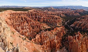
The exposed geology of the Bryce Canyon area in Utah shows a record of deposition that covers the last part of the Cretaceous Period and the first half of the Cenozoic era in that part of North America. The ancient depositional environment of the region around what is now Bryce Canyon National Park varied from the warm shallow sea in which the Dakota Sandstone and the Tropic Shale were deposited to the cool streams and lakes that contributed sediment to the colorful Claron Formation that dominates the park's amphitheaters.

<span class="mw-page-title-main">Colorado Plateau</span> Plateau in southwestern United States

The Colorado Plateau, also known as the Colorado Plateau Province, is a physiographic and desert region of the Intermontane Plateaus, roughly centered on the Four Corners region of the southwestern United States. This province covers an area of 336,700 km2 (130,000 mi2) within western Colorado, northwestern New Mexico, southern and eastern Utah, northern Arizona, and a tiny fraction in the extreme southeast of Nevada. About 90% of the area is drained by the Colorado River and its main tributaries: the Green, San Juan, and Little Colorado. Most of the remainder of the plateau is drained by the Rio Grande and its tributaries.

<span class="mw-page-title-main">Hoodoo (geology)</span> Tall, thin spire of relatively soft rock usually topped by harder rock

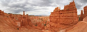
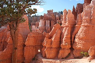
A hoodoo is a tall, thin spire of rock formed by erosion. Hoodoos typically consist of relatively soft rock topped by harder, less easily eroded stone that protects each column from the elements. They generally form within sedimentary rock and volcanic rock formations.

<span class="mw-page-title-main">Paunsaugunt Plateau</span> Plateau in Utah, USA

The Paunsaugunt Plateau is a dissected plateau, rising to an elevation of 7,000–9,300 feet (2,100–2,800 m), in southwestern Utah in the United States. Located in northern Kane County and southwestern Garfield County, it is approximately 10 miles (16 km) wide, and extends southward from the Sevier Plateau approximately 25 miles (40 km), terminating in the Pink Cliffs at the southern end.

<span class="mw-page-title-main">History of the Grand Canyon area</span>

The known human history of the Grand Canyon area stretches back 10,500 years, when the first evidence of human presence in the area is found. Native Americans have inhabited the Grand Canyon and the area now covered by Grand Canyon National Park for at least the last 4,000 of those years. Ancestral Pueblo peoples, first as the Basketmaker culture and later as the more familiar Pueblo people, developed from the Desert Culture as they became less nomadic and more dependent on agriculture. A similar culture, the Cochimi also lived in the canyon area. Drought in the late 13th century likely caused both groups to move on. Other people followed, including the Paiute, Cerbat, and the Navajo, only to be later forced onto reservations by the United States Government.

<span class="mw-page-title-main">Horseshoe Bend (Arizona)</span> Landform in the Colorado River, Coconino County, Arizona

Horseshoe Bend is a horseshoe-shaped incised meander of the Colorado River located near the town of Page, Arizona, United States. It is also referred to as the "east rim of the Grand Canyon."

<span class="mw-page-title-main">Zion Canyon</span>

Zion Canyon is a deep and narrow gorge in southwestern Utah, United States, carved by the North Fork of the Virgin River. Nearly the entire canyon is located within the western half of Zion National Park.

<span class="mw-page-title-main">Zion National Park</span> National park in Utah, United States

Zion National Park is an American national park located in southwestern Utah near the town of Springdale. Located at the junction of the Colorado Plateau, Great Basin, and Mojave Desert regions, the park has a unique geography and a variety of life zones that allow for unusual plant and animal diversity. Numerous plant species as well as 289 species of birds, 75 mammals, and 32 reptiles inhabit the park's four life zones: desert, riparian, woodland, and coniferous forest. Zion National Park includes mountains, canyons, buttes, mesas, monoliths, rivers, slot canyons, and natural arches. The lowest point in the park is 3,666 ft (1,117 m) at Coalpits Wash and the highest peak is 8,726 ft (2,660 m) at Horse Ranch Mountain. A prominent feature of the 229-square-mile (590 km2) park is Zion Canyon, which is 15 miles (24 km) long and up to 2,640 ft (800 m) deep. The canyon walls are reddish and tan-colored Navajo Sandstone eroded by the North Fork of the Virgin River. The park attracted 5 million visitors in 2023.

<span class="mw-page-title-main">Utah State Route 143</span> Highway in Utah

State Route 143 (SR-143) is a state highway in the U.S. state of Utah. The entire highway has been designated the Brian Head-Panguitch Lake Scenic Byway as part of the Utah Scenic Byways program. This road has also been designated as Utah's Patchwork Parkway as part of the National Forest Scenic Byway and National Scenic Byway programs.

<span class="mw-page-title-main">Historical buildings and structures of Zion National Park</span> United States historic place

The historical buildings and structures of Zion National Park represent a variety of buildings, interpretive structures, signs and infrastructure associated with the National Park Service's operations in Zion National Park, Utah. Structures vary in size and scale from the Zion Lodge to road culverts and curbs, nearly all of which were designed using native materials and regional construction techniques in an adapted version of the National Park Service Rustic style. A number of the larger structures were designed by Gilbert Stanley Underwood, while many of the smaller structures were designed or coordinated with the National Park Service Branch of Plans and Designs. The bulk of the historic structures date to the 1920s and 1930s. Most of the structures of the 1930s were built using Civilian Conservation Corps labor.

<span class="mw-page-title-main">Under-the-Rim Trail</span> United States historic place

The Under-the-Rim Trail is a 22.9-mile (36.9 km) hiking trail in Bryce Canyon National Park, Utah. The trail was established by the National Park Service to provide access to the portions of the park located below the rim of the Paunsaugunt Plateau, whose edge forms the eroded natural amphitheater for which the park is famous. Plans dating to 1932 proposed the trail so that wooded portions of the park's east side could be accessed, primarily for fire suppression activities rather than for access to scenic features. Work began on the trail in 1934, using Civilian Conservation Corps labor from CCC Camp NP-3, with work continuing into 1935.

<span class="mw-page-title-main">Bryce Canyon National Park Scenic Trails Historic District</span> Historic district in Utah, United States

The Bryce Canyon National Park Scenic Trails Historic District is a historic trail system in the central part of Bryce Canyon National Park in southwestern Garfield County, Utah, United States, that is listed on the National Register of Historic Places (NRHP).

<span class="mw-page-title-main">Grand Canyon Inn and Campground</span> United States historic place

The Grand Canyon Inn and Campground, also known as the North Rim Inn, were built by the William W. Wylie and the Utah Parks Company as inexpensive tourist accommodations on the North Rim of the Grand Canyon, in Grand Canyon National Park. Intended to complement the more expensive Grand Canyon Lodge, the cabins and Inn were located near Bright Angel Point, but father back than their more expensive counterparts, near the Grand Canyon North Rim Headquarters. The design of the cabins and the redesign of the Inn building were undertaken by architect Gilbert Stanley Underwood.

The Hayduke Trail is an 812-mile (1,307 km) backpacking route across southern Utah and northern Arizona. It begins in Arches National Park near Moab, Utah, before heading through the Needles district of Canyonlands National Park, Capitol Reef National Park, Bryce Canyon National Park, the Grand Canyon National Park and ending in Zion National Park.

References

Further reading