Navajo Sandstone

Last updated
Navajo Sandstone
Stratigraphic range: Hettangian-Sinemurian
~200–195  Ma
O
S
D
C
P
T
J
K
Pg
N
SanRafaelReefUT.jpg
A prominent cuesta of Navajo Sandstone rims the edge of the San Rafael Swell in eastern Utah
Type Geological formation
Unit of Glen Canyon Group
Underlies Carmel Formation and Page and Temple Cap sandstones, separated by J-1 and J-2 unconformities
Overlies Kayenta Formation with conformable and interfingering contact
ThicknessUp to 2,300 ft (700 m)
Lithology
PrimaryEolian sandstone
OtherLacustrine limestone and dolomite
Location
Coordinates 36°42′N110°48′W / 36.7°N 110.8°W / 36.7; -110.8 Coordinates: 36°42′N110°48′W / 36.7°N 110.8°W / 36.7; -110.8
Approximate paleocoordinates 23°54′N48°30′W / 23.9°N 48.5°W / 23.9; -48.5
RegionArizona, Colorado, Nevada, Utah
Country United States of America
Extent102,300 sq mi (264,955.8 km2) - original extent of the Navajo Sand Sea may have been 2.5 times larger than this remaining outcrop
Type section
Named for Navajo County
Named byGregory and Stone [1]
Year defined1917
Usa edcp relief location map.png
Blue pog.svg
Navajo Sandstone (the United States)
USA Arizona relief location map.svg
Blue pog.svg
Navajo Sandstone (Arizona)

The Navajo Sandstone is a geological formation in the Glen Canyon Group that is spread across the U.S. states of southern Nevada, northern Arizona, northwest Colorado, and Utah as part of the Colorado Plateau province of the United States. [2]

Contents

Description

The Permian through Jurassic stratigraphy of the Colorado Plateau area of southeastern Utah that makes up much of the famous prominent rock formations in protected areas such as Capitol Reef National Park and Canyonlands National Park. From top to bottom: Rounded tan domes of the Navajo Sandstone, layered red Kayenta Formation, cliff-forming, vertically jointed, red Wingate Sandstone, slope-forming, purplish Chinle Formation, layered, lighter-red Moenkopi Formation, and white, layered Cutler Formation sandstone. Picture from Glen Canyon National Recreation Area, Utah. SEUtahStrat.JPG
The Permian through Jurassic stratigraphy of the Colorado Plateau area of southeastern Utah that makes up much of the famous prominent rock formations in protected areas such as Capitol Reef National Park and Canyonlands National Park. From top to bottom: Rounded tan domes of the Navajo Sandstone, layered red Kayenta Formation, cliff-forming, vertically jointed, red Wingate Sandstone, slope-forming, purplish Chinle Formation, layered, lighter-red Moenkopi Formation, and white, layered Cutler Formation sandstone. Picture from Glen Canyon National Recreation Area, Utah.

The Navajo Sandstone is particularly prominent in southern Utah, where it forms the main attractions of a number of national parks and monuments including Red Rock Canyon National Conservation Area, [3] Zion National Park, Capitol Reef National Park, Glen Canyon National Recreation Area, Grand Staircase–Escalante National Monument, and Canyonlands National Park.

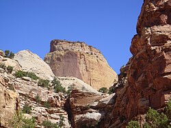
Navajo Sandstone frequently overlies and interfingers with the Kayenta Formation of the Glen Canyon Group. Together, these formations can result in immense vertical cliffs of up to 2,200 feet (670 m). Atop the cliffs, Navajo Sandstone often appears as massive rounded domes and bluffs that are generally white in color.

Appearance and provenance

The Great White Throne in Zion National Park is an example of white Navajo Sandstone Great White Throne in Zion.jpg
The Great White Throne in Zion National Park is an example of white Navajo Sandstone
Stevens Arch, near the mouth of Coyote Gulch in the Canyons of the Escalante, is formed from a layer of Navajo Sandstone. The opening is 220 feet (67 m) wide and 160 feet (49 m) high. StevensArchUT.jpg
Stevens Arch, near the mouth of Coyote Gulch in the Canyons of the Escalante, is formed from a layer of Navajo Sandstone. The opening is 220 feet (67 m) wide and 160 feet (49 m) high.

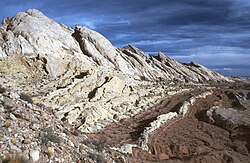
Navajo Sandstone frequently occurs as spectacular cliffs, cuestas, domes, and bluffs rising from the desert floor. It can be distinguished from adjacent Jurassic sandstones by its white to light pink color, meter-scale cross-bedding, and distinctive rounded weathering.

The wide range of colors exhibited by the Navajo Sandstone reflect a long history of alteration by groundwater and other subsurface fluids over the last 190 million years. The different colors, except for white, are caused by the presence of varying mixtures and amounts of hematite, goethite, and limonite filling the pore space within the quartz sand comprising the Navajo Sandstone. The iron in these strata originally arrived via the erosion of iron-bearing silicate minerals.

Initially, this iron accumulated as iron-oxide coatings, which formed slowly after the sand had been deposited. Later, after having been deeply buried, reducing fluids composed of water and hydrocarbons flowed through the thick red sand which once comprised the Navajo Sandstone. The dissolution of the iron coatings by the reducing fluids bleached large volumes of the Navajo Sandstone a brilliant white. Reducing fluids transported the iron in solution until they mixed with oxidizing groundwater. Where the oxidizing and reducing fluids mixed, the iron precipitated within the Navajo Sandstone.

Depending on local variations within the permeability, porosity, fracturing, and other inherent rock properties of the sandstone, varying mixtures of hematite, goethite, and limonite precipitated within spaces between quartz grains. Variations in the type and proportions of precipitated iron oxides resulted in the different black, brown, crimson, vermillion, orange, salmon, peach, pink, gold, and yellow colors of the Navajo Sandstone.

The precipitation of iron oxides also formed laminae, corrugated layers, columns, and pipes of ironstone within the Navajo Sandstone. Being harder and more resistant to erosion than the surrounding sandstone, the ironstone weathered out as ledges, walls, fins, "flags", towers, and other minor features, which stick out and above the local landscape in unusual shapes. [4] [5]

Age and history of investigation

The age of the Navajo Sandstone is somewhat controversial. It may originate from the Late Triassic but is at least as young as the Early Jurassic stages Pliensbachian and Toarcian. [2] There is no type locality of the name. It was simply named for the 'Navajo Country' of the southwestern United States. [6] The two major subunits of the Navajo are the Lamb Point Tongue (Kanab area) and the Shurtz Sandstone Tongue (Cedar City area). [7]

The Navajo Sandstone was originally named as the uppermost formation of the La Plata Group by Gregory and Stone in 1917. [6] Baker reassigned it as the upper formation of Glen Canyon Group in 1936. [8] Its age was modified by Lewis and others in 1961. [9] The name was originally not used in northwest Colorado and northeast Utah, where the name 'Glen Canyon Sandstone' was preferred. [10] Its age was modified again by Padian in 1989. [11]

A 2019 radioisotopic analysis suggests that the Navajo Sandstone formation is entirely Jurassic, extending for about 5.5 million years from the Hettangian age to the Sinemurian age. [12]

Depositional environment

The sandstone was deposited in an arid erg on the Western portion of the Supercontinent Pangaea. This region was affected by annual monsoons that came about each winter when cooler winds and wind reversal occurred.

Outcrop localities

The Golden Throne, a rock formation in Capitol Reef National Park. Though the park is famous for white domes of the Navajo Sandstone, this dome's color is a result of a lingering section of yellow Carmel Formation carbonate, which has stained the underlying rock. GoldenThrone.JPG
The Golden Throne, a rock formation in Capitol Reef National Park. Though the park is famous for white domes of the Navajo Sandstone, this dome's color is a result of a lingering section of yellow Carmel Formation carbonate, which has stained the underlying rock.

Navajo Sandstone outcrops are found in these geologic locations:

The formation is also found in these parklands (incomplete list):

Vertebrate paleofauna

Ornithodires

Indeterminate theropod remains geographically located in Arizona, USA. [13] Theropod tracks are geographically located in Arizona, Colorado, and Utah, USA. [13] Ornithischian tracks located in Arizona, USA. [13]

Color key
Taxon Reclassified taxonTaxon falsely reported as presentDubious taxon or junior synonym Ichnotaxon Ootaxon Morphotaxon
Notes
Uncertain or tentative taxa are in small text; crossed out taxa are discredited.
Ornithodires of the Navajo Sandstone
GenusSpeciesLocationStratigraphic positionMaterialNotesImages

Ammosaurus [13]

Ammosaurus cf. major [13]

Ammosaurus Ammosaurus2.png
Ammosaurus
Segisaurus Segisaurus.jpg
Segisaurus
Seitaad Seitaad NT.jpg
Seitaad

Dilophosaurus [14]

D. wetherilli [14]

Attributed trackways at Red Fleet State Park. [14]

Pteraichnus [15]

Segisaurus [13]

S. halli [13]

"Partial postcranial skeleton."

Seitaad [16]

S. ruessi [16]

Iron oxide concretions

Interior of a Moqui Marble Broken Moqui Marble.jpg
Interior of a Moqui Marble
Moqui Marbles, hematite concretions, from the Navajo Sandstone of southeast Utah. Scale cube, with "W", is one centimeter square. MoquiMarble1.jpg
Moqui Marbles, hematite concretions, from the Navajo Sandstone of southeast Utah. Scale cube, with "W", is one centimeter square.
Moqui marbles in place in the Navajo Sandstone, Snow Canyon State Park, SW Utah. Moqui marbles in situ Navajo SW UT.jpg
Moqui marbles in place in the Navajo Sandstone, Snow Canyon State Park, SW Utah.

The Navajo Sandstone is also well known among rockhounds for its hundreds of thousands of iron oxide concretions. Informally, they are called "Moqui marbles" and are believed to represent an extension of Hopi Native American traditions regarding ancestor worship ("moqui" translates to "the dead" in the Hopi language). Thousands of these concretions weather out of outcrops of the Navajo Sandstone within south-central and southeastern Utah within an area extending from Zion National Park eastward to Arches and Canyonland national parks. They are quite abundant within Grand Staircase–Escalante National Monument. [4] [5]

The iron oxide concretions found in the Navajo Sandstone exhibit a wide variety of sizes and shapes. Their shape ranges from spheres to discs; buttons; spiked balls; cylindrical hollow pipe-like forms; and other odd shapes. Although many of these concretions are fused together like soap bubbles, many more also occur as isolated concretions, which range in diameter from the size of peas to baseballs. The surface of these spherical concretions can range from being very rough to quite smooth. Some of the concretions are grooved spheres with ridges around their circumference. [4] [5]

The abundant concretions found in the Navajo Sandstone consist of sandstone cemented together by hematite (Fe2O3), and goethite (FeOOH). The iron forming these concretions came from the breakdown of iron-bearing silicate minerals by weathering to form iron oxide coatings on other grains. During later diagenesis of the Navajo Sandstone while deeply buried, reducing fluids, likely hydrocarbons, dissolved these coatings. When the reducing fluids containing dissolved iron mixed with oxidizing groundwater, they and the dissolved iron were oxidized. This caused the iron to precipitate out as hematite and goethite to form the innumerable concretions found in the Navajo Sandstone. Evidence suggests that microbial metabolism may have contributed to the formation of some of these concretions. [17] These concretions are regarded as terrestrial analogues of the hematite spherules, called alternately Martian "blueberries" or more technically Martian spherules, which the Opportunity rover found at Meridiani Planum on Mars. [4] [5]

See also

Related Research Articles

Entrada Sandstone

The Entrada Sandstone is a formation in the San Rafael Group found in the U.S. states of Wyoming, Colorado, northwest New Mexico, northeast Arizona, and southeast Utah. Part of the Colorado Plateau, this formation was deposited during the Jurassic Period sometime between 180 and 140 million years ago in various environments, including tidal mudflats, beaches, and sand dunes. The Middle Jurassic San Rafael Group was dominantly deposited as ergs in a desert environment around the shallow Sundance Sea.

Rainbow Bridge National Monument Natural bridge in San Juan County, Utah, United States

Rainbow Bridge National Monument is administered by Glen Canyon National Recreation Area, southern Utah, United States. Rainbow Bridge is often described as the world's highest natural bridge. The span of Rainbow Bridge was reported in 1974 by the Bureau of Reclamation to be 275 feet (84 m), but a measurement of span according to definition by the Natural Arch and Bridge Society in 2007 resulted in a value of 234 feet (71 m). At the top it is 42 feet (13 m) thick and 33 feet (10 m) wide. The bridge, which is of cultural importance to a number of area Native American tribes, has been designated a Traditional Cultural Property by the National Park Service.

Lake Powell Reservoir in Utah and Arizona, United States

Lake Powell is an artificial reservoir on the Colorado River in Utah and Arizona, United States. It is a major vacation destination visited by approximately two million people every year. It is the second largest artificial reservoir by maximum water capacity in the United States behind Lake Mead, storing 25,166,000 acre-feet (3.1042×10¹⁰ m3) of water when full. However, Lake Mead has fallen below Lake Powell in size several times during the 21st century in terms of volume of water, depth and surface area.

Lees Ferry Historical Colorado River ferry crossing

Lees Ferry is a site on the Colorado River in Coconino County, Arizona in the United States, about 7.5 miles (12.1 km) southwest of Page and 9 miles (14 km) south of the Utah–Arizona state line.

Geology of the Zion and Kolob canyons area Geology of Zion National Park in Utah

The geology of the Zion and Kolob canyons area includes nine known exposed formations, all visible in Zion National Park in the U.S. state of Utah. Together, these formations represent about 150 million years of mostly Mesozoic-aged sedimentation in that part of North America. Part of a super-sequence of rock units called the Grand Staircase, the formations exposed in the Zion and Kolob area were deposited in several different environments that range from the warm shallow seas of the Kaibab and Moenkopi formations, streams and lakes of the Chinle, Moenave, and Kayenta formations to the large deserts of the Navajo and Temple Cap formations and dry near shore environments of the Carmel Formation.

Colorado Plateau Plateau in the Four Corners region of the Southwest United States

The Colorado Plateau, also known as the Colorado Plateau Province, is a physiographic and desert region of the Intermontane Plateaus, roughly centered on the Four Corners region of the southwestern United States. This province covers an area of 336,700 km2 (130,000 mi2) within western Colorado, northwestern New Mexico, southern and eastern Utah, northern Arizona, and a tiny fraction in the extreme southeast of Nevada. About 90% of the area is drained by the Colorado River and its main tributaries: the Green, San Juan, and Little Colorado. Most of the remainder of the plateau is drained by the Rio Grande and its tributaries.

Grand Staircase Landform in Utah and Arizona, United States

The Grand Staircase is an immense sequence of sedimentary rock layers that stretch south from Bryce Canyon National Park and Grand Staircase–Escalante National Monument, through Zion National Park, and into the Grand Canyon National Park.

Morrison Formation Rock formation in the western United States

The Morrison Formation is a distinctive sequence of Upper Jurassic sedimentary rock found in the western United States which has been the most fertile source of dinosaur fossils in North America. It is composed of mudstone, sandstone, siltstone, and limestone and is light gray, greenish gray, or red. Most of the fossils occur in the green siltstone beds and lower sandstones, relics of the rivers and floodplains of the Jurassic period.

Horseshoe Bend (Arizona) Landform in the Colorado River, Coconino County, Arizona

Horseshoe Bend is a horseshoe-shaped incised meander of the Colorado River located near the town of Page, Arizona, United States. It is also referred to as the "east rim of the Grand Canyon."

The Wave (Arizona) Rock formation in the Vermilion Cliffs National Monument in Arizona, US

The Wave is a sandstone rock formation located in Arizona, United States, near its northern border with Utah. The formation is situated on the slopes of the Coyote Buttes in the Paria Canyon-Vermilion Cliffs Wilderness of the Colorado Plateau. The area is administered by the Bureau of Land Management (BLM) at the Grand Staircase–Escalante National Monument visitor center in Kanab, Utah.

Vermilion Cliffs Landform in Utah and Arizona, United States

The Vermilion Cliffs are the second "step" up in the five-step Grand Staircase of the Colorado Plateau, in northern Arizona and southern Utah. They extend west from near Page, Arizona, for a considerable distance, in both Arizona and Utah.

Moenkopi Formation Geologic feature in the Southwestern United States

The Moenkopi Formation is a geological formation that is spread across the U.S. states of New Mexico, northern Arizona, Nevada, southeastern California, eastern Utah and western Colorado. This unit is considered to be a group in Arizona. Part of the Colorado Plateau and Basin and Range, this red sandstone was laid down in the Lower Triassic and possibly part of the Middle Triassic, around 240 million years ago.

Glen Canyon Group Group of geologic formations in the Colorado Plateau

The Glen Canyon Group is a geologic group of formations that is spread across the U.S. states of Nevada, Utah, northern Arizona, north west New Mexico and western Colorado. It is called the Glen Canyon Sandstone in the Green River Basin of Colorado and Utah.

The San Rafael Group is a geologic group or collection of related rock formations that is spread across the U.S. states of New Mexico, Arizona, Utah and Colorado. As part of the Colorado Plateau, this group of formations was laid down in the Middle Jurassic during the Bajocian, Bathonian and Callovian Stages.

Carmel Formation

The Carmel Formation is a geologic formation in the San Rafael Group that is spread across the U.S. states of Wyoming, Utah, Colorado, north east Arizona and New Mexico. Part of the Colorado Plateau, this formation was laid down in the Middle Jurassic during the late Bajocian, through the Bathonian and into the early Callovian stages.

Navajo Mountain Landform in Utah and Arizona, United States

Navajo Mountain is a peak in San Juan County, Utah, with its southern flank extending into Coconino County, Arizona, in the United States. It holds an important place in the traditions of three local Native American tribes. The summit is the highest point on the Navajo Nation.

Wingate Sandstone

The Wingate Sandstone is a geologic formation in the Glen Canyon Group of the Colorado Plateau province of the United States which crops out in northern Arizona, northwest Colorado, Nevada, and Utah.

Kayenta Formation Jurassic sandstone formation of southwestern United States

The Kayenta Formation is a geological formation in the Glen Canyon Group that is spread across the Colorado Plateau province of the United States, including northern Arizona, northwest Colorado, Nevada, and Utah. Traditionally has been suggested as Sinemurian-Pliensbachian, but more recent dating of detrital zircons has yielded a depositional age of 183.7 ± 2.7 Ma, thus a Pliensbachian-Toarcian age is more likely A previous depth work recovered a solid Lower-Middle Pliensbachian age from measurements done in the Tenney Canyon.

Moenave Formation

The Moenave Formation is a Mesozoic geologic formation, in the Glen Canyon Group. It is found in Utah and Arizona.

Kayentavenator is a genus of small carnivorous tetanuran dinosaur that lived during the Early Jurassic Period; fossils were recovered from the Kayenta Formation of northeastern Arizona and were described in 2010.

References

  1. Gregory, HE (1917), Geology of the Navajo country; a reconnaissance of parts of Arizona, New Mexico, and Utah (PDF), doi:10.3133/PP93, Wikidata   Q61049764
  2. 1 2 Anonymous (2011b) Navajo Sandstone Archived 2006-09-23 at the Wayback Machine , Stratigraphy of the Parks of the Colorado Plateau Archived 2010-12-24 at the Wayback Machine . U.S. Geological Survey, Reston, Virginia. last accessed August 18, 2013
  3. Red Rock Canyon National Conservation Area - Rock Climbing. Archived 2013-05-19 at the Wayback Machine Southern Nevada District Office, Bureau of Land Management, Reno, Nevada
  4. 1 2 3 4 Chan, MA, and WT Parry (2002) Mysteries of Sandstone Colors and Concretions in Colorado Plateau Canyon Country. PDF version, 468 KB Public Information Series no. 77. Utah Geological Survey, Salt Lake City, Utah.
  5. 1 2 3 4 Chan, M., BB Beitler, WT Parry, J Ormo, and G Komatsu (2005) Red Rock and Red Planet Diagenesis: Comparison of Earth and Mars Concretions. PDF version, 3.4 MB. GSA Today. vol. 15, no. 8, pp. 4–10.
  6. 1 2 Gregory, Herbert Ernest (1917). Geology of the Navajo Country: A Reconnaissance of Parts of Arizona, New Mexico and Utah. U.S. Government Printing Office. pp. 23–31. ISBN   978-0341722533 . Retrieved 8 April 2021.
  7. Averitt, P and RF Wilson, JS Detterman, JW Harshbarger, CA Repenning (1955) Revisions in correlation and nomenclature of Triassic and Jurassic formations in southwestern Utah and northern Arizona. American Association of Petroleum Geologists Bulletin. 39(12):2515–2524.
  8. Baker, AA (1936) Geology of the Monument Valley-Navajo Mountain region, San Juan County, Utah. Bulletin no. 865. U.S. Geological Survey, Reston, Virginia. 106 pp.
  9. Lewis, GE, JH Irwin, and RF Wilson (1961) Age of the Glen Canyon Group (Triassic and Jurassic) on the Colorado Plateau. Geological Society of America Bulletin. 72(9):1437–1440.
  10. Poole, FG, and JH Stewart (1964) Chinle Formation and Glen Canyon Sandstone in northeastern Utah and northwestern Colorado. In Geological Survey research 1964. Professional Paper, no. 501-D, pp. D30-D39, U.S. Geological Survey, Reston, Virginia.
  11. Padian, K (1989) Presence of dinosaur Scelidosaurus indicates Jurassic age for the Kayenta Formation (Glen Canyon Group, northern Arizona). Geology. 17(5):438-441.
  12. Judith Totman Parrish, E. Troy Rasbury, Marjorie A. Chan & Stephen T. Hasiotis (2019) Earliest Jurassic U-Pb ages from carbonate deposits in the Navajo Sandstone, southeastern Utah, USA. Geology 47(11): 1015-1019.
  13. 1 2 3 4 5 6 7 8 9 Weishampel, DB, P Dodson, and H Osmólska, Halszka (2007) The Dinosauria, 2nd, Berkeley: University of California Press. 861 pp. ISBN   0-520-24209-2.
  14. 1 2 3 4 Gillman, Andrew Dash. "Following the Dinosaur Tracks of Red Fleet State Park". Visit Utah. Retrieved 21 February 2018.
  15. Lockley, M, JD Harris, and L Mitchell (2008) A global overview of pterosaur ichnology: tracksite distribution in space and time. Zitteliana. B28:187-198.
  16. 1 2 3 Sertich, JJW and M Loewen (2010) A new basal sauropodomorph dinosaur from the Lower Jurassic Navajo Sandstone of southern Utah. PLoS ONE. 5(3)
  17. Weber, WA, TL Spanbauer, D Wacey, MR Kilburn, DB Loope, and RM Kettler (2012) Biosignatures link microorganisms to iron mineralization in a paleoaquifer. Geology. 40(8):747–750.

Further reading

General

Scientific publications