The Lance (Creek) Formation is a division of Late Cretaceous rocks in the western United States. Named after Lance Creek, Wyoming, the microvertebrate fossils and dinosaurs represent important components of the latest Mesozoic vertebrate faunas. The Lance Formation is Late Maastrichtian in age, and shares much fauna with the Hell Creek Formation of Montana and North Dakota, the Frenchman Formation of southwest Saskatchewan, and the lower part of the Scollard Formation of Alberta.

The Scollard Formation is an Upper Cretaceous to lower Palaeocene stratigraphic unit of the Western Canada Sedimentary Basin in southwestern Alberta. Its deposition spanned the time interval from latest Cretaceous to early Paleocene, and it includes sediments that were deposited before, during, and after the Cretaceous-Paleogene (K-Pg) extinction event. It is significant for its fossil record, and it includes the economically important coal deposits of the Ardley coal zone.
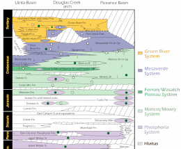
The Cedar Mountain Formation is the name given to a distinctive sedimentary geologic formation in eastern Utah, spanning most of the early and mid-Cretaceous. The formation was named for Cedar Mountain in northern Emery County, Utah, where William Lee Stokes first studied the exposures in 1944.

The Cloverly Formation is a geological formation of Early and Late Cretaceous age that is present in parts of Montana, Wyoming, Colorado and Utah in the western United States. It was named for a post office on the eastern side of the Bighorn Basin in Wyoming by N.H. Darton in 1904. The sedimentary rocks of formation were deposited in floodplain environments and contain vertebrate fossils, including a diverse assemblage of dinosaur remains. In 1973, the Cloverly Formation Site was designated as a National Natural Landmark by the National Park Service.

The Dakota is a sedimentary geologic unit name of formation and group rank in Midwestern North America. The Dakota units are generally composed of sandstones, mudstones, clays, and shales deposited in the Mid-Cretaceous opening of the Western Interior Seaway. The usage of the name Dakota for this particular Albian-Cenomanian strata is exceptionally widespread; from British Columbia and Alberta to Montana and Wisconsin to Colorado and Kansas to Utah and Arizona. It is famous for producing massive colorful rock formations in the Rocky Mountains and the Great Plains of the United States, and for preserving both dinosaur footprints and early deciduous tree leaves.
The Naturita Formation is a classification used in western Colorado and eastern Utah for a Cretaceous Period sedimentary geologic formation. This name was "applied to the upper or carbonaceous part of Dakota Group" by R.G. Young in 1960, naming it for Naturita, Colorado. The name is not used by U.S. Geological Survey authors, but has found growing acceptance by the Utah Geological Survey

The Bearpaw Formation, also called the Bearpaw Shale, is a geologic formation of Late Cretaceous (Campanian) age. It outcrops in the U.S. state of Montana, as well as the Canadian provinces of Alberta and Saskatchewan, and was named for the Bear Paw Mountains in Montana. It includes a wide range of marine fossils, as well as the remains of a few dinosaurs. It is known for its fossil ammonites, some of which are mined in Alberta to produce the organic gemstone ammolite.

The Pierre Shale is a geologic formation or series in the Upper Cretaceous which occurs east of the Rocky Mountains in the Great Plains, from Pembina Valley in Canada to New Mexico.

The Wayan Formation is a geological formation in Idaho whose strata date back to the latest Early Cretaceous and the earliest Late Cretaceous. Dinosaur, other reptile, mammal, and micro and macro-floral remains are among the fossils that have been recovered from the formation. The lack of extensive outcrops, limited geographic extent, and extreme structural deformation have limited paleontological explorations of the Wayan.
The Toolebuc Formation is a geological formation that extends from Queensland across South Australia and the Northern Territory in Australia, whose strata date back to the Albian stage of the Early Cretaceous. Dinosaurs, pterosaurs, plesiosaurs, ichthyosaurs, protostegid turtles, sharks, chimaeroids and bony fish remains are among the fossils that have been recovered from the formation.

The Frontier Formation is a sedimentary geological formation whose strata date back to the Late Cretaceous. The formation's extents are: northwest Colorado, southeast Idaho, southern Montana, northern Utah, and western Wyoming. It occurs in many sedimentary basins and uplifted areas.

The Fox Hills Formation is a Cretaceous geologic formation in the northwestern Great Plains of North America. It is present from Alberta on the north to Colorado in the south.

The Tropic Shale is a Mesozoic geologic formation. Dinosaur remains are among the fossils that have been recovered from the formation, including Nothronychus graffami. The Tropic Shale is a stratigraphic unit of the Kaiparowits Plateau of south central Utah. The Tropic Shale was first named in 1931 after the town of Tropic where the Type section is located. The Tropic Shale outcrops in Kane and Garfield counties, with large sections of exposure found in the Grand Staircase–Escalante National Monument.
The Plainview Formation is an Early Cretaceous (Albian) geologic formation of the Dakota Group in Colorado. Fossil ankylosaur tracks and tracks of Caririchnium sp. have been reported from the formation.

The Mancos Shale or Mancos Group is a Late Cretaceous geologic formation of the Western United States.

The Graneros Shale is a geologic formation in the United States identified in the Great Plains as well as New Mexico that dates to the Cenomanian Age of the Cretaceous Period. It is defined as the finely sandy argillaceous or clayey near-shore/marginal-marine shale that lies above the older, non-marine Dakota sand and mud, but below the younger, chalky open-marine shale of the Greenhorn. This definition was made in Colorado by G. K. Gilbert and has been adopted in other states that use Gilbert's division of the Benton's shales into Carlile, Greenhorn, and Graneros. These states include Kansas, Texas, Oklahoma, Nebraska, and New Mexico as well as corners of Minnesota and Iowa. North Dakota, South Dakota, Wyoming, and Montana have somewhat different usages — in particular, north and west of the Black Hills, the same rock and fossil layer is named Belle Fourche Shale.

The Greenhorn Limestone or Greenhorn Formation is a geologic formation in the Great Plains Region of the United States, dating to the Cenomanian and Turonian ages of the Late Cretaceous period. The formation gives its name to the Greenhorn cycle of the Western Interior Seaway.
The Thermopolis Shale is a geologic formation which formed in west-central North America in the Albian age of the Late Cretaceous period. Surface outcroppings occur in central Canada, and the U.S. states of Montana and Wyoming. The rock formation was laid down over about 7 million years by sediment flowing into the Western Interior Seaway. The formation's boundaries and members are not well-defined by geologists, which has led to different definitions of the formation. Some geologists conclude the formation should not have a designation independent of the formations above and below it. A range of invertebrate and small and large vertebrate fossils and coprolites are found in the formation.
The geology of Alberta encompasses parts of the Canadian Rockies and thick sedimentary sequences, bearing coal, oil and natural gas, atop complex Precambrian crystalline basement rock.