Kaibab Limestone

Last updated
Kaibab Limestone
Stratigraphic range: Early to Middle Permian, Leonardian to Roadian [1] [2] [3]
Grand Canyon National Park- The Kaibab from South Kaibab Trail.jpg
Bedded and jointed cliffs of the Kaibab Limestone at the Grand Canyon.
(high resolution, expandable photo)
Type Geological formation
Sub-unitsFossil Mountain and Harrisburg members
Underlies Moenkopi Formation
Overlies Toroweap Formation, Coconino Sandstone, and White Rim Sandstone
Thickness300 feet (91 m)-500 feet (150 m) in Grand Canyon region.
Lithology
Primaryfossiliferous limestone, sandy limestone, dolomite, and chert
Other gypsum, siltstone, and sandstone
Location
Region Arizona–(northern)
California–(southeast)
Nevada–(east-central) and,
Utah–(southern)
Country United States – (Southwestern United States)
Type section
Named forIt was named for the Kaibab Plateau, northern Arizona [4]
Named byDarton (1910) [4]
Geology showing the basal layer (Kaibab Formation) of Zion National Park, southern Utah Zion-Nationalpark-Gesteinsschichten.svg
Geology showing the basal layer (Kaibab Formation) of Zion National Park, southern Utah

The Kaibab Limestone is a resistant cliff-forming, Permian geologic formation that crops out across the U.S. states of northern Arizona, southern Utah, east central Nevada and southeast California. It is also known as the Kaibab Formation in Arizona, Nevada, and Utah. The Kaibab Limestone forms the rim of the Grand Canyon. In the Big Maria Mountains, California, the Kaibab Limestone is highly metamorphosed and known as the Kaibab Marble. [2] [3]

Contents

Nomenclature

Grand Canyon view
The rim top layer is the Kaibab Limestone Grand Canyon layers (cropped).jpg
Grand Canyon view
The rim top layer is the Kaibab Limestone
Walnut Canyon, Flagstaff Arizona WalnutCanyonNorthWall.jpg
Walnut Canyon, Flagstaff Arizona

The Kaibab Limestone was named by Darton [4] in 1910 for the Kaibab Plateau, which is on the north side of Grand Canyon in Coconino County, Arizona. In his definition of the Kaibab Limestone formation, no type locality was designated. He also designated the Kaibab Limestone as the upper formation of the Aubrey Group, a now-abandoned stratigraphic unit. In 1921, Bassler and Reeside revised Darton's work and defined the Harrisburg Member of the Kaibab Limestone. [5] In his 1938 monograph on the Toroweap Formation and Kaibab Limestone of northern Arizona, [6] McKee split Darton's original Kaibab Limestone into the currently recognized Kaibab Limestone and Toroweap Formation. He also revised Kaibab Limestone's lower contact and divided it into informal (descending) alpha, beta and gamma members. Later in the 1970s, its upper contact was revised and its areal extent were defined. Also, unsuccessful attempts were made to raise the formation to group rank and divide it into several formations. In 1982, Warren Hamilton renamed it as the Kaibab Marble and determined its areal extent for California. [7] In 1991, Sorauf and Billingsley subdivided the Kaibab Limestone into (ascending) Fossil Mountain Member (new) and Harrisburg Member. [8] They designated the strata comprising McKee's alpha (or upper) member as the Harrisburg Member and the strata comprising McKee's beta (or middle) member as the Fossil Mountain Member. The Fossil Mountain Member was named for Fossil Mountain along the south rim near the Bass Trail. McKee's gamma member is considered to be part of the Fossil Mountain Member. Later research has further redefined the regional extent of the Kaibab Limestone. [1] [2] [3]

Description

The Kaibab Limestone is an assemblage of sedimentary rock types. It consists of a complexity of inter fingering and inter bedded carbonate and siliciclastic sedimentary rocks. In addition, intense post-depositional (diagenetic) changes have created more composition variation by the alteration of limestone to dolomite and the silicification of limestone to form chert. In the western Grand Canyon region, the Fossil Mountain Member consists of fossiliferous and cherty limestone with an abundant and diverse normal-marine fossil fauna. Further east in the Coconino Plateau region, the lithology, mineralogy, and fauna of the Fossil Mountain Member changes drastically where it grades laterally into sandy dolomite and dolomite that contains a restricted-marine fossil fauna and subordinate amounts of sandstone. The Harrisburg Member, which forms the uppermost cliffs and receding ledges along both north and south rims of the Grand Canyon, consists of an assemblage of gypsum, dolomite, sandstone, redbeds, chert, and minor limestone. [1] [2] [3] [6]

Contacts

Within the Grand Canyon region, the Kaibab Limestone overlies gypsum and contorted sandstones of the Toroweap Formation. Originally, geologists interpreted the lower contact of the Kaibab Limestone to be an unconformity based on the presence of local intraformational breccias and erosional surfaces. [6] However, additional research has concluded that these local intraformational breccias and erosional surfaces are the result of collapse following the dissolution of evaporite deposits within the upper part of the Toroweap Formation. As a result, this contact is inferred to be conformable or only locally a disconformity. South and east of the Grand Canyon, the evaporites and contorted sandstones (sabkha deposits) of Toroweap Formation interfinger with and are replaced by cross-bedded sandstones of the Coconino Sandstone. As a result, the Kaibab Limestone directly overlies the Coconino Sandstone in the Mogollon Rim region. The Kaibab Limestone directly overlies the White Rim Sandstone in northeastern Arizona and southeastern Utah. [1] [6]

The upper contact of the Kaibab Limestone (Harrisburg Member) with the overlying Moenkopi Formation is an erosional unconformity and disconformity. Within northwestern Arizona, southeastern Nevada, and southwestern Utah this contact is an erosional unconformity that in part consists of paleovalleys, as much as several hundred feet deep, and paleokarst that were eroded into the underlying Kaibab Limestone before the deposition of the Moenkopi Formation. These paleovalleys are often filled with conglomerates and breccias that are known as the Rock Canyon conglomerate. Within the Marble Canyon and eastern Grand Canyon regions and south into Verde Valley, upper contact of the Kaibab Limestone with the Moenkopi Formation is an erosional disconformity. This disconformity exhibits little relief and is identified by marked differences in color, topography, and rock types between tan, ledge-forming, calcareous sandstones and of the Kaibab Limestone and red, slope-forming siltstones of the Moenkopi formation. The unconformity and disconformity are inferred to represent most of Permian time (including the Leonardian) and part of Early Triassic time. [1] [6] [8]

Although the Moenkopi Formation overlies the Kaibab Limestone, its redbeds have been removed almost entirely by erosion because they are less resistant to erosion than the strata of the Kaibab Formation. As a result, the Kaibab Limestone forms the surface of many of the vast plateaus that border the Grand Canyon. Within these plateaus, the uppermost beds of the Kaibab Limestone have also been largely removed by erosion. [1]

Fossils

The Kaibab Limestone contains the abundant fossils of Permian invertebrates and vertebrates. The invertebrate fossils found within the Kaibab Limestone include brachiopods, conodonts, corals, crinoids, echinoid spines, mollusks, hexactinellid and other sponges, trilobites, and burrows of callanassid shrimp. The fossil cephalopods found in the Kaibab Limestone include giant football-sized nautiloids. [1] [6] Fossil shark teeth, which represent a diverse assemblage of chondrichthyans, occur within the Kaibab Limestone of Arizona. [6] [9] [10]

Depositional environments

The complex intercalation of carbonate and clastic sediments within the Kaibab Limestone reflects the deposition of sediments within a gently sloping continental margin during a period of frequent, high-frequency sea level changes. Relatively minor changes in sea level caused major lateral shifts in the position of supratidal, subtidal, and shallow-marine environments during the deposition of the Kaibab Limestone. The shifting sea levels and associated depositional environments created a complex interlayering of different types of carbonate and clastic sediments in the strata that comprise the Kaibab Limestone. The gently sloping continental margin on which the Kaibab Limestone accumulated, extended seaward from northern Arizona to southern Nevada, at times exceeding 200 miles (125 km) in width. It is most likely that the high-frequency changes in sea level were caused by glacial sea level oscillations during this time period. [1]

Age

Early paleontological studies of the Kaibab Limestone firmly established its age on the basis of the abundant fossils that it and the underlying Toroweap Formation contain. On the basis of its brachiopod and siliceous sponge faunas, it was initially concluded that it is Leonardian (approximately Kungurian / latest Early Permian) in age. [1] [6] [11] Later research concerning conodonts and associated megafossils obtained from western outcrops of the Fossil Mountain Member indicates that its age extends into the Roadian (latest Early Permian and earliest Middle Permian) age. [1] [12]

Geographic distribution

Geologic Province: [3]

Parklands (incomplete list):

Other:

See also

Related Research Articles

<span class="mw-page-title-main">Geology of the Grand Canyon area</span> Aspect of geology

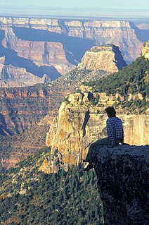
The geology of the Grand Canyon area includes one of the most complete and studied sequences of rock on Earth. The nearly 40 major sedimentary rock layers exposed in the Grand Canyon and in the Grand Canyon National Park area range in age from about 200 million to nearly 2 billion years old. Most were deposited in warm, shallow seas and near ancient, long-gone sea shores in western North America. Both marine and terrestrial sediments are represented, including lithified sand dunes from an extinct desert. There are at least 14 known unconformities in the geologic record found in the Grand Canyon.

<span class="mw-page-title-main">Geology of the Zion and Kolob canyons area</span> Geology of Zion National Park in Utah

The geology of the Zion and Kolob canyons area includes nine known exposed formations, all visible in Zion National Park in the U.S. state of Utah. Together, these formations represent about 150 million years of mostly Mesozoic-aged sedimentation in that part of North America. Part of a super-sequence of rock units called the Grand Staircase, the formations exposed in the Zion and Kolob area were deposited in several different environments that range from the warm shallow seas of the Kaibab and Moenkopi formations, streams and lakes of the Chinle, Moenave, and Kayenta formations to the large deserts of the Navajo and Temple Cap formations and dry near shore environments of the Carmel Formation.

<span class="mw-page-title-main">Grand Staircase</span> Landform in Utah and Arizona, United States

The Grand Staircase is an immense sequence of sedimentary rock layers that stretch south from Bryce Canyon National Park and Grand Staircase–Escalante National Monument, through Zion National Park, and into the Grand Canyon National Park.

<span class="mw-page-title-main">Moenkopi Formation</span> Geologic feature in the Southwestern United States

The Moenkopi Formation is a geological formation that is spread across the U.S. states of New Mexico, northern Arizona, Nevada, southeastern California, eastern Utah and western Colorado. This unit is considered to be a group in Arizona. Part of the Colorado Plateau and Basin and Range, this red sandstone was laid down in the Lower Triassic and possibly part of the Middle Triassic, around 240 million years ago.

Coconino Sandstone Geologic formation

Coconino Sandstone is a geologic formation named after its exposure in Coconino County, Arizona. This formation spreads across the Colorado Plateau province of the United States, including northern Arizona, northwest Colorado, Nevada, and Utah.

<span class="mw-page-title-main">Hurricane Cliffs</span> Landform in Arizona and Utah, United States


The Hurricane Cliffs of southwest Utah and northwest Arizona are a red, limestone geographic feature, sets of cliffs along the western, eroded edge of the Kaibab Limestone; the cliffs are about 135-mi (217 km) long, with the south end terminus just north of the Grand Canyon. The cliffs are associated with the Hurricane Fault.

<span class="mw-page-title-main">Tonto Group</span> Cambrian geologic unit in the Grand Canyon region, Arizona

The Tonto Group is a name for an assemblage of related sedimentary strata, collectively known by geologists as a Group, that comprises the basal sequence Paleozoic strata exposed in the sides of the Grand Canyon. As currently defined, the Tonto groups consists of the Sixtymile Formation, Tapeats Sandstone, Bright Angel Shale, Muav Limestone, and Frenchman Mountain Dolostone. Historically, it included only the Tapeats Sandstone, Bright Angel Shale, and Muav Limestone. Because these units are defined by lithology and three of them interfinger and intergrade laterally, they lack the simple layer cake geology as they are typically portrayed as having and geological mapping of them is complicated.

<span class="mw-page-title-main">Muav Limestone</span> Geologic strata in Southwestern United States

The Cambrian Muav Limestone is a geologic unit within the 5-member Tonto Group. It is about 650 feet (198 m) thick at its maximum. It is a resistant cliff-forming unit. The Muav consists of dark to light-gray, brown, and orange red limestone with dolomite and calcareous mudstone. The Muav Limestone is overlain in the western Grand Canyon by the late Cambrian Frenchman Mountain Dolostone. Eastward, the Frenchman Mountain Dolostone pinches out and the Mississippian Redwall Limestone, which forms prominent vertical cliffs, directly lies upon the Muav Limestone. The Devonian Temple Butte Formation fill deep paleovalleys that have been cut through the Frenchman Mountain Dolostone and into the Muav Limestone.

Toroweap Formation Middle Permian geologic unit in the Grand Canyon

The Middle Permian Toroweap Formation is a thin, darker geologic unit, between the brighter colored units of the Kaibab Limestone above, and Coconino Sandstone below. It is a prominent unit in Grand Canyon, Arizona, USA, found through sections of the South Rim, Grand Canyon, and the North Rim, of the Kaibab Plateau; also the Kaibab's southeast extension to Cape Royal, the Walhalla Plateau. The Colorado River of the Grand Canyon makes its excursion from due-south to due-west around the Walhalla Plateau, as it enters the east end of the Grand Canyon's interior, Granite Gorge. The formation is also found in southeast Utah.

<span class="mw-page-title-main">Toroweap Fault</span> Geologic feature in the Grand Canyon, Arizona

The Toroweap Fault of northwest Arizona and southwest Utah is part of a fault system of the west Grand Canyon region, Arizona, US; also the west perimeter regions of the Coconino and Colorado Plateaus. The Hurricane Fault originates at the Toroweap Fault, in the region of the Colorado River, and strikes as the westerly depression of the Toroweap Fault. The Toroweap strikes northerly from the Colorado at the east of Toroweap Valley, and enters south Utah; from the Colorado River, the Hurricane Fault strikes north-northwest along the west flank of the small, regional Uinkaret Mountains, the west border of Toroweap Valley. The Hurricane Fault, and the Hurricane Cliffs strike into southwest Utah as part of the west, and southwest perimeter of the Colorado Plateau. The Hurricane Cliffs are made of Kaibab Limestone, an erosion resistant, cliff-forming rock unit.

<span class="mw-page-title-main">Isis Temple</span> Landform in the Grand Canyon, Arizona

Isis Temple is a prominence in the Grand Canyon, Arizona, Southwestern United States. It is located below the North Rim and adjacent to Granite Gorge. The prominence lies north of the north bank of the west-flowing Colorado River and is just north of Granite Gorge. The Trinity Creek and canyon flow due south at its west border; its north, and northeast border/flank is formed by Phantom Creek and canyon, a west tributary of Bright Angel Creek; the creeks intersect about 3 mi (4.8 km) southeast, and 1.0 mi (1.6 km) north of Granite Gorge. The Isis Temple prominence, is only about 202 ft (62 m) lower than Grand Canyon Village, the main public center on Grand Canyon’s South Rim.

Esplanade Sandstone Geologic unit found in the Grand Canyon

The Lower Permian Esplanade Sandstone is a cliff-forming, resistant sandstone, dark red, geologic unit found in the Grand Canyon. The rock unit forms a resistant shelf in the west Grand Canyon, south side of the Colorado River, at the east of the Toroweap Fault, down-dropped to west, southeast of Toroweap Overlook, and west of Havasupai. The red, sandstone shelf, The Esplanade is about 20-mi long. At Toroweap Overlook region, Toroweap Valley with Vulcan's Throne, Uinkaret volcanic field, the resistant Esplanade Sandstone is described in access routes exploring the Toroweap Lake area.

<span class="mw-page-title-main">Supai Group</span> Section of red bed deposits at the Colorado Plateau

The Supai Group is a slope-forming section of red bed deposits found in the Colorado Plateau. The group was laid down during the Pennsylvanian to Lower Permian. Cliff-forming interbeds of sandstone)are noticeable throughout the group. The Supai Group is especially exposed throughout the Grand Canyon in northwest Arizona, as well as local regions of southwest Utah, such as the Virgin River valley region. It occurs in Arizona at Chino Point, Sycamore Canyon, and famously at Sedona as parts of Oak Creek Canyon. In the Sedona region, it is overlain by the Hermit Formation, and the colorful Schnebly Hill Formation.

White Rim Sandstone

The White Rim Sandstone is a sandstone geologic formation located in southeastern Utah. It is the last member of the Permian Cutler Group, and overlies the major Organ Rock Formation and Cedar Mesa Sandstone; and again overlies thinner units of the Elephant Canyon and Halgaito Formations.

<span class="mw-page-title-main">Shinarump Conglomerate</span>

The Shinarump Conglomerate is a geologic formation found in the Four Corners region of the United States. It was deposited in the early part of the Late Triassic period.

<span class="mw-page-title-main">Hermit Formation</span> Geologic formation in the Grand Canyon

The Permian Hermit Formation, also known as the Hermit Shale, is a nonresistant unit that is composed of slope-forming reddish brown siltstone, mudstone, and very fine-grained sandstone. Within the Grand Canyon region, the upper part of the Hermit Formation contains red and white, massive, calcareous sandstone and siltstone beds that exhibit low-angle cross-bedding. Beds of dark red crumbly siltstone fill shallow paleochannels that are quite common in this formation. The siltstone beds often contain poorly preserved plant fossils. The Hermit Formation varies in thickness from about 100 feet (30 m) in the eastern part of the Grand Canyon region to about 900 feet (270 m) in the region of Toroweap and Shivwits Plateaus. In the Sedona, Arizona area, it averages 300 feet (91 m) in thickness. The upper contact of the Hermit Formation is typically sharp and lacks gradation of any kind. The lower contact is a disconformity characterized by a significant amount of erosional relief, including paleovalleys as much as 60 feet (18 m) deep.

Temple Butte Formation Landform in the Grand Canyon, Arizona

The Devonian Temple Butte Formation, also called Temple Butte Limestone, outcrops through most of the Grand Canyon of Arizona, USA; it also occurs in southeast Nevada. Within the eastern Grand Canyon, it consists of thin, discontinuous and relatively inconspicuous lenses that fill paleovalleys cut into the underlying Muav Limestone. Within these paleovalleys, it at most, is only about 100 feet (30 m) thick at its maximum. Within the central and western Grand Canyon, the exposures are continuous. However, they tend to merge with cliffs of the much thicker and overlying Redwall Limestone.

<span class="mw-page-title-main">Confucius Temple (Grand Canyon)</span> Landform in the Grand Canyon, Arizona

Confucius Temple is a 7,081-foot-elevation (2,158 meter) summit located in the Grand Canyon, in Coconino County of northern Arizona, US. It is situated 1.5 mile southeast of Point Sublime, four miles west-northwest of Shiva Temple, and three miles northwest of Tower of Ra, where it rises over 3,200 feet (1,130 meters) above Hindu Amphitheater. Confucius Temple is named for Confucius, the Chinese philosopher. This name was applied by Clarence Dutton, who began the tradition of naming geographical features in the Grand Canyon after mythological deities. Confucius Temple is one of the Twin Buttes in the Grand Canyon, the other being Mencius Temple, which is named for Mencius, considered the second-most famous sage, after only Confucius himself. This mountain's name was officially adopted in 1906 by the U.S. Board on Geographic Names. According to the Köppen climate classification system, Confucius Temple has a Cold semi-arid climate.

<span class="mw-page-title-main">Fossil Mountain (Grand Canyon)</span> Summit in Coconino County, Arizona

Fossil Mountain is a 6,729-foot-elevation summit located in the Western Grand Canyon, in Coconino County of northern Arizona, Southwestern United States. It is situated ~1.5 miles due east of Mount Huethawali, about 1.0 miles southeast of the Grand Scenic Divide, and 1.0 mi west of Havasupai Point.

The Fossil Mountain prominence is a massif-remainder cliff of Kaibab Limestone, and stands above a tableland of the South Rim, a forested plateau of Kaibab Limestone.

<span class="mw-page-title-main">Vesta Temple</span> Landform in the Grand Canyon, Arizona

Vesta Temple is a 6,299-foot-elevation (1,920 meter) summit located in the Grand Canyon, in Coconino County of northern Arizona, US. It is situated eight miles west-northwest of Grand Canyon Village, and immediately northeast of Mimbreno Point. Marsh Butte is one mile northeast, Eremita Mesa immediately southeast, and nearest higher neighbor Diana Temple is one mile north. Topographic relief is significant as Vesta Temple rises 3,900 feet (1,190 meters) above the Colorado River in 2.5 miles. Vesta Temple is named for Vesta, the goddess of the hearth, home, and family according to Roman mythology. Clarence Dutton began the practice of naming geographical features in the Grand Canyon after mythological deities. This geographical feature's name was officially adopted in 1908 by the U.S. Board on Geographic Names. According to the Köppen climate classification system, Vesta Temple is located in a Cold semi-arid climate zone.

References

  1. 1 2 3 4 5 6 7 8 9 10 Hopkins, R. L., and K. L. Thompson, 2003, Kiabab Formation. in: Beus, S.S., Morales, M., eds., pp. 196–211, Grand Canyon Geology, 2nd. Oxford University Press, New York. ISBN   978-0-19-512299-2, 448 pp.
  2. 1 2 3 4 Anonymous, 2014, Kaibab Limestone. Stratigraphy of the Parks of the Colorado Plateau. Archived 2010-12-24 at the Wayback Machine . U.S. Geological Survey, Reston, Virginia.
  3. 1 2 3 4 5 Stamm, N., 2013, Geologic Unit: Kaibab.. U.S. Geological Survey, Reston, Virginia.
  4. 1 2 3 Darton, N. H., 1910, A reconnaissance of parts of northwestern New Mexico and northern Arizona. Bulletin no. 435. U.S. Geological Survey, Reston, Virginia. 88 pp.
  5. Bassler, H., and J. B. Reeside, Jr., 1921, Oil prospects in Washington County, Utah, Chapter C. in D. White and M. R. Campbell, eds., pp. C87–C107, Contributions to economic geology (short papers and preliminary reports), 1921, Part II. Mineral fuels. Bulletin no. 726. U.S. Geological Survey, Reston, Virginia.
  6. 1 2 3 4 5 6 7 8 McKee, E. D., 1938, The environment and history of the Toroweap Formation and Kaibab formations of northern Arizona and southern Utah. Publication, no. 492. Carnegie Institution of Washington, Washington, DC. 268 pp.
  7. Hamilton, W. H., 1982, Structural evolution of the Big Maria Mountains, northeastern Riverside County, southeastern California. in E. G. Frost and D. L. Martin, eds., pp. 1–27, Mesozoic-Cenozoic tectonic evolution of the Colorado River region, California, Arizona, and Nevada. Cordilleran Publishers, San Diego, California, United States. 608 pp.
  8. 1 2 Sorauf, J. E. and G. H. Billingsley, 1991, Members of the Toroweap and Kaibab Formations, Lower Permian, northern Arizona and southwestern Utah. The Mountain Geologist, 28(1):9–24.
  9. Hodnett, J.-P., D. K. Elliott, T. J. Olson, and J. H. Wittke, 2012, Ctenacanthiform sharks from the Permian Kaibab Formation, northern Arizona. Historical Biology. 24:1–15.
  10. Hodnett, J.-P., D. K. Elliott, and T. J. Olson, 2013, A new basal hybodont (Chondrichthyes, Hybodontiformes) from the Middle Permian (Roadian) Kaibab Formation of northern Arizona. In, S. G. Lucas, W. A. DiMichele, J. A. Barrick, J. W. Schneider, and J. S. Spielman, eds., pp. 103–08, The Carboniferous-Permian Transition. Bulletin no. 60. New Mexico Museum of Natural History and Science, Socorro, New Mexico.
  11. Griffen, L. R., 1966. Actinocoelia maendria Finks, from the Kaibab Limestone of Northern Arizona. Brigham Young University Geology Studies. 13:105–08.
  12. Thompson, K. L., 1995., Paleoecology and Biostratigraphy of the Fossil Mountain Member, Kaibab Formation, in Northwestern Arizona. Unpublished M.S. thesis, Northern Arizona University, 160 pp.
  13. Joseph V. Tingley (2008). Geologic Tours in the Las Vegas Area: Expanded Edition with GPS Coordinates. NV Bureau of Mines & Geology. pp. 23–. ISBN   978-1-888035-12-4.