Fishlake National Forest

Last updated
Fishlake National Forest
AspenOverview0172.JPG
Fishlake National Forest
Usa edcp relief location map.png
Red pog.svg
Location Beaver, Garfield, Iron, Juab, Millard, Piute, Sanpete, Sevier, and Wayne counties, Utah, USA
Nearest city Richfield, UT
Coordinates 38°42′30″N111°57′33″W / 38.70833°N 111.95917°W / 38.70833; -111.95917 [1]
Area1,461,226 acres (5,913.37 km2) [2]
EstablishedJuly 1, 1908 [3]
Visitors500,000(in 2006 [4] )
Governing body U.S. Forest Service
Website Fishlake National Forest
Image of Trail in Fish Lake National Forest.jpg

Fishlake National Forest is a U.S. National Forest located in south central Utah. The namesake for the forest is Fish Lake, the largest freshwater mountain lake in the state. [5]

Contents

Wildlife

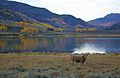
Animals that inhabit this forest are elk, shrews, deer, black bears, coyotes, various species of bats, moose, raccoons, two species of skunks, badgers, turkey vultures, two species of eagles, pika, snowshoe hares, various species of woodpeckers, pine marten, porcupines, four species of hummingbirds, beavers, kestrels, pronghorn, various species of owls, bobcats, minks, three species of fox, cougars, mountain lions, bighorn sheep, wild turkeys, and mountain goats.

Geography

Established in 1908 from the merging of Fish Lake National Forest and Glenwood National Forest, the forest covers 1.5 million acres (6,100 km2) and is split into four districts. The forest lies in parts of nine counties. In descending order of forestland area, they are Sevier, Millard, Piute, Beaver, Wayne, Juab, Garfield, Iron, and Sanpete counties. Forest headquarters are located in Richfield with local ranger district offices in Beaver, Fillmore, Loa, and Richfield. [6] The national forest is the headwaters of Otter Creek, a tributary of the East Fork Sevier River. It is also home to the Chalk Creek Hieroglyphics.

Pando, a clonal quaking aspen stand, that, according to some sources, is the oldest (80,000 years) and largest (106 acres, 13 million pounds) organism on Earth, is located in the Fremont River Ranger District of the National Forest, 1 mile southwest of Fish Lake on Utah route 25. [7]

Acquisition

Native water rights to Fish Lake were sold to the Fremont Irrigation Company on March 10, 1889, for nine horses, 500 pounds of flour, one steer, and a suit of clothes. Ten years later President William McKinley created a Forest Reserve which included Fish Lake. [8]

Fishlake National Forest map Fishlake National Forest Map.jpg
Fishlake National Forest map

See also

Related Research Articles

<span class="mw-page-title-main">Beaver County, Utah</span> County in Utah, United States

Beaver County is a county in west central Utah, United States. As of the 2020 United States Census, the population was 7,072, up from the 2010 figure of 6,629. Its county seat and largest city is Beaver. The county was named for the abundance of beaver in the area.

<span class="mw-page-title-main">Millard County, Utah</span> County in Utah, United States

Millard County is a county in the U.S. state of Utah. As of the 2020 United States Census, the population was 12,975. Its county seat is Fillmore, and the largest city is Delta.

<span class="mw-page-title-main">Sanpete County, Utah</span> County in Utah, United States

Sanpete County is a county in the U.S. state of Utah. As of the 2020 United States Census, the population was 28,437. Its county seat is Manti, and its largest city is Ephraim. The county was created in 1850.

<span class="mw-page-title-main">Sevier County, Utah</span> County in Utah, United States

Sevier County is a county in Utah, United States. As of the 2020 United States Census, the population was 21,522. Its county seat and largest city is Richfield.

<span class="mw-page-title-main">Wayne County, Utah</span> County in Utah, United States

Wayne County is a county in the U.S. state of Utah. As of the 2020 census, the population was 2,486, making it the fourth-least populous county in Utah. Its county seat is Loa.

<span class="mw-page-title-main">Richfield, Utah</span> City in the United States

Richfield is a city in and the county seat of Sevier County, Utah, United States, and is the largest city in southern-central Utah.

<span class="mw-page-title-main">Sevier River</span> River in central Utah, United States

The Sevier River is a 400-mile (640 km)-long river in the Great Basin of southwestern Utah in the United States. Originating west of Bryce Canyon National Park, the river flows north through a chain of high farming valleys and steep canyons along the west side of the Sevier Plateau before turning southwest and terminating in the endorheic basin of Sevier Lake in the Sevier Desert. It is used extensively for irrigation along its course, with the consequence that Sevier Lake is usually dry.

<span class="mw-page-title-main">Dixie National Forest</span> US National Forest in Utah

Dixie National Forest is a United States National Forest in Utah with headquarters in Cedar City. It occupies almost two million acres (8,000 km2) and stretches for about 170 miles (270 km) across southern Utah. The largest national forest in Utah, it straddles the divide between the Great Basin and the Colorado River. In descending order of forestland area it is located in parts of Garfield, Washington, Iron, Kane, Wayne, and Piute counties. The majority of forest acreage lies in Garfield County.

<span class="mw-page-title-main">Fish Lake (Utah)</span> Lake in the state of Utah, United States

Fish Lake is a high alpine lake located in the Fishlake/ Southern Wasatch Plateau region of south-central Utah, United States. It lies within and is the namesake of the Fishlake National Forest.

<span class="mw-page-title-main">Fremont–Winema National Forest</span> Protected area in the U.S. state of Oregon

The Fremont–Winema National Forest is a United States National Forest formed from the 2002 merger of the Fremont and Winema National Forests. They cover territory in southern Oregon from the crest of the Cascade Range on the west past the city of Lakeview to the east. The northern end of the forests is bounded by U.S. Route 97 on the west and Oregon Route 31 on the east. To the south, the state border with California forms the boundary of the forests. Klamath Falls is the only city of significant size in the vicinity. The forests are managed by the United States Forest Service, and the national forest headquarters are located in Lakeview.

There are several lakes named Mud Lake in the U.S. state of Utah.

<span class="mw-page-title-main">Tushar Mountains</span> Mountain range in Utah, United States

The Tushar Mountains are the third-highest mountain range in Utah after the Uinta Mountains and the La Sal Range. Located in the Fishlake National Forest, Delano Peak, 12,174 ft  NAVD 88, is the highest point in both Beaver and Piute counties and has a prominence of 4,689 ft. Delano Peak is named for Columbus Delano (1809–1896), Secretary of the Interior, during the Grant administration. The Tushars receive an ample amount of snow annually even though they are situated within the rainshadow of the Sierra Nevada range in California and the Snake Range located in Nevada.

<span class="mw-page-title-main">Utah State Route 25</span> State highway in Utah, United States

State Route 25 (SR-25), also part of the designated Fishlake Scenic Byway, is a state highway in the south central portion of the U.S. state of Utah. SR-25 runs from the junction of SR-24 near the town of Koosharem northeast to the west shore of Fish Lake. The highway runs for 9.995 miles (16.09 km).

<span class="mw-page-title-main">Pando (tree)</span> Largest known organism

Pando, the world's largest tree, is a quaking aspen tree located in Central Utah in the Fishlake National Forest. A male clonal organism, Pando has an estimated 47,000 stems (ramets) that appear as individual trees, but are connected by a root system that spans 106 acres. Pando is the largest tree by weight and landmass and, is the largest known aspen clone. Pando was identified as a single living organism because each of its stems possesses identical genetic markers. The massive interconnected root system coordinates energy production, defense and regeneration across its expanse. Pando spans 0.63 miles by 0.43 miles of the southwestern edge of the Fishlake Basin in the Fremont River Ranger District of the Fishlake National Forest and lies 0.43 miles to the west of Fish Lake, the largest natural mountain freshwater lake in Utah. Pando is located at an elevation of 2,700 m (8,900 ft) above sea level.

The Paiute ATV Trail is a public all-terrain vehicle trail system that is located in central Utah. It is managed by the Fishlake National Forest and the Richfield District of the Bureau of Land Management.

The Canyon Mountains are a 25-mile (40 km) long mountain range located in the northeast corner of Millard County, Utah; the range is bisected north-south with a southeast border section of Juab County.

<span class="mw-page-title-main">Canal Fire</span>

The Canal Fire was a wildfire that burned Millard County in Utah in the United States. First reported on June 26, 2020, the fire burned 78,065 acres (31,592 ha) on public land, including Fishlake National Forest and land owned by the Bureau of Land Management. Started by a lightning strike, the fire was contained on June 27, only to escape containment on June 28 due to strong winds. The fire led to the mandatory evacuation of Fool Creek Peak and Leamington, Utah. It was contained on July 11, 2020.

Birch Creek is a northwesterly-flowing 8.4 miles (13.5 km) stream in Beaver County, Utah. It originates on the western slope of Birch Creek Mountain in the Tushar Mountains in Fishlake National Forest, and its waters flow west into South Creek, then under Interstate 15 south of the town of Beaver, and thence to the Beaver River, and ultimately to the Sevier River and Lake.

References

  1. "Fishlake National Forest". Geographic Names Information System. United States Geological Survey. Retrieved 2012-12-26.
  2. "Land Areas of the National Forest System" (PDF). U.S. Forest Service. January 2012. Retrieved June 30, 2012.
  3. "The National Forests of the United States" (PDF). ForestHistory.org. Archived from the original (PDF) on October 28, 2012. Retrieved July 30, 2012.
  4. Staff (April 2010). "Utah Forest Highway Long Range Transportation Plan" (PDF). Central Federal Lands Highway Division. Archived from the original (PDF) on 16 September 2012. Retrieved 27 May 2012.
  5. "About Us" - Fishlake National Forest
  6. "USFS Ranger Districts by State" (PDF). Archived from the original (PDF) on 2012-01-19. Retrieved 2009-05-17.
  7. "Pando". USDA Forest Service. Retrieved 2013-08-24.
  8. "History of the Fishlake National Forest". USDA Forest Service web site. Retrieved 17 October 2011.

Further reading