Sierra National Forest

Last updated
Sierra National Forest
Lake of the Lone Indian JMW.jpg
Lake of the Lone Indian, John Muir Wilderness
Usa edcp relief location map.png
Red pog.svg
Map of the United States
Location Sierra Nevada, Central California
Nearest city Oakhurst, California
Coordinates 37°25′N119°10′W / 37.417°N 119.167°W / 37.417; -119.167
Area1,300,000 acres (5,300 km2)
Established1893;131 years ago (1893)
Governing body U.S. Forest Service
Website Sierra National Forest

Sierra National Forest is a U.S. national forest located on the western slope of the central Sierra Nevada in California, bounded on the northwest by Yosemite National Park and on the south by Kings Canyon National Park. The forest is known for its mountain scenery and beautiful lakes. Forest headquarters are located in Clovis, California. There are local ranger district offices in North Fork and Prather. [1]

Contents

History

Sierra National Forest was the second National Forest created in California and the largest at the time. It covered over six million acres (24,000 km2) of the Sierra Nevada and was about four times the average area of typical California National Forests. Originally it embraced parts of eight counties from Tuolumne on the north to Kern on the south and Mono and Inyo on the east. Initially its name was descriptive, but later when the Sierra was divided into different units this was no longer the case.

President Harrison proclaimed the Sierra Forest Reserve on February 14, 1893. Four years later the south half became a separate unit and was named Sierra South during the "forest reserves" era. This designation was dropped after the administrative transition to the National Forests on March 4, 1907. On July 1, 1908, the Sequoia National Forest, and Kings Canyon and Sequoia National Parks were established from this south portion of Sierra National Forest. Eastern portions of Sierra National Forest became the Inyo and Toiyabe National Forests; northern portions were used for Yosemite National Park and the Stanislaus National Forest.

The Sierra National Forest contains artifacts dating back over 10,000 years, mainly from indigenous people before written records started about 150 years ago. Around the late 1700s, the Fresno River marked the area between the Southern Sierra Miwok and the Chukchansi Yokuts, with the Western Mono living near today's Bass Lake. The borders between these groups were not clear-cut, showing that the Miwok, Yokuts, and Mono territories often overlapped. [2]

The first timber sale on a California National Forest took place in the Sierra NF by the United States General Land Office in 1899. [3]

Geography

Area map Sierra National Forest map.png
Area map

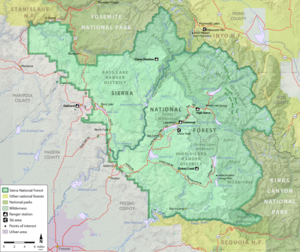
Sierra National Forest covers, in descending order of forestland area, the eastern portions of Fresno, Madera, and Mariposa counties, adjacent to the southern part of Yosemite National Park. It includes more than 1,300,000 acres (2,000 sq mi; 5,300 km2), at altitudes ranging from 900 to 13,986 feet (274 to 4,263 m) in elevation. The terrain includes rolling, oak-covered foothills, heavily forested middle elevation slopes and the tundra landscape of the High Sierra.

Boundaries

The forest's boundary starts clockwise at the intersections of the Merced River, Sweetwater Creek and HWY 140, then moves east following the Merced River canyon to the border with Yosemite National Park near El Portal. Then it follows the park's southern boundary until it reaches the Inyo National forest near Electra Peak. From there it travels south to its border with Kings Canyon National Park near Mount Goethe. It follows the park's northern border, then heads south to the Kings River near Deer Canyon. From there it moves down the Kings River canyon east; south of the river is the Sequoia National Forest. When it reaches Pine Flat Lake near Trimmer, it turns north towards Tollhouse and continues on to Auberry. From there Sierra National Forest moves on to North Fork, then west to form a small finger towards Coarsegold. Finally, the boundary travels north to Yosemite Forks and moves west towards Miami Mountain, then heads north to return to the Merced River.

Recreation

The forest includes a number of scenic attractions, including Fresno Dome and Nelder Grove. Several reservoirs offer fishing and boating, including Bass Lake, Shaver Lake, Wishon Reservoir, and Courtright Reservoir. There are numerous hiking opportunities in wilderness areas: Ansel Adams, John Muir, Dinkey Lakes, Kaiser, and Monarch. There is also a ski resort, China Peak, that operates under a special use permit. Great sailing opportunities exist at Huntington Lake.

Administration

The Sierra National Forest is located within the Pacific Southwest region of the US Forest Service. The forest is divided into three ranger districts:

Bass Lake Ranger District is north and west of the San Joaquin River. Its Ranger District office is located at 57003 Road 225 North Fork, California, 93643. The district includes 36 camp sites, 17 picnic sites, 7 Off Highway Vehicle Trails, and 10 trails. It includes the Forest Service Offices of Oakhurst (40343 Hwy 41, Oakhurst, California 93644), and the Clover Meadow Wilderness Office.

High Sierra Ranger District is south and east of the San Joaquin River; it has its Ranger District office out of 29688 Auberry Rd P.O. Box 559 Prather, California 93651. This district contains 30 camp sites, 11 picnic sites, and 13 Off Highway Vehicle Trails. It also includes the following Forest Service Offices; the High Sierra visitor information station near Mono Hot Springs on the Kaiser Pass Road, Eastwood visitor information center at Hwy 168 and Kaiser Pass Road at Huntington Lake, Dinkey Creek visitor information center on Dinkey Creek Road near the Dinkey Creek Campground,

Supervisor's Office (an administrative Unit) contains the Sierra National Forest Supervisor's office (1600 Tollhouse Rd Clovis, California, 93611); the Yosemite Sierra Visitor Bureau (40343 Highway 41, Oakhurst, California 93644); and the Fresno Air Attack Base which is co-located with the Sierra National Forest Emergency Communications Center (2307 and 2309 N Clovis Ave, Fresno, California 93727) at Fresno Yosemite International Airport.

In addition, the forest has a close relationship with the Teakettle Experimental Forest which is deep inside the forest and the San Joaquin Experimental Range which is just outside the forest boundaries. They both fall in the Pacific Southwest Research Station which is based in Berkeley, California. [4]

Ecology

The ecology of the National Forest is typical for the western side of the southern Sierra Nevada: distributions of species are largely governed by climate, which is strongly dependent on altitude. The ecology can be described by biotic zones, which are marked by either a tree indicator species, or by a lack of trees. The biotic zones include the foothill woodland zone from 1,000 to 3,000 feet (300 to 910 m) (interior live oak), the lower montane zone from 3,000 to 7,000 feet (910 to 2,130 m) (Ponderosa pine), the upper montane zone from 7,000 to 9,000 feet (2,100 to 2,700 m) (lodgepole pine/red fir), the subalpine zone from 9,000 to 9,500 feet (2,700 to 2,900 m) (whitebark pine), and the alpine zone from 9,500 feet (2,900 m) (above the tree line). [5]

Some 383,000 acres (598 sq mi; 1,550 km2) of the forest are old growth, containing lodgepole pine (Pinus contorta) and red fir (Abies magnifica). [6]

National monument proposal

A campaign to designate the national forest as a national monument was begun in 2015. [7] The proposal for the 1,400,000-acre (5,700 km2)Range of Light National Monument would prevent new mining operations and phase out logging and grazing, resulting in a continuous protected area linking Yosemite, Sequoia, and Kings Canyon national parks. [8] Former Sequoia National Park ranger Deanna Lynn Wulff founded the organization Unite the Parks to campaign for the monument's establishment. [9] [10] [11] [12] The proposal has been endorsed by numerous local businesses and organizations, a group of 200 scientists, [8] the California Democratic Party, [13] Democratic National Committee, [14] Sierra Club, [15] and the Coalition to Protect America's National Parks. [16] The protection of old-growth trees would contribute to the 30 by 30 initiative. It is opposed by Congressman Tom McClintock and the logging industry. [8]

In December 2022, Congressmembers Jackie Speier and Jerry McNerney introduced a bill that would establish Range of Light National Monument comprising the entirety of Sierra National Forest and the San Joaquin Gorge managed by the Bureau of Land Management. The new national monument would be administered by the National Park Service, [17] which would manage land for conservation rather than multiple-use.

Unite the Parks has also led a lawsuit to prevent logging in fisher habitat. [18] [19]

See also

Related Research Articles

<span class="mw-page-title-main">Yosemite National Park</span> National park in California, United States

Yosemite National Park is a national park in California. It is bordered on the southeast by Sierra National Forest and on the northwest by Stanislaus National Forest. The park is managed by the National Park Service and covers 759,620 acres in four counties – centered in Tuolumne and Mariposa, extending north and east to Mono and south to Madera. Designated a World Heritage Site in 1984, Yosemite is internationally recognized for its granite cliffs, waterfalls, clear streams, giant sequoia groves, lakes, mountains, meadows, glaciers, and biological diversity. Almost 95 percent of the park is designated wilderness. Yosemite is one of the largest and least fragmented habitat blocks in the Sierra Nevada.

<span class="mw-page-title-main">Sierra Nevada</span> Mountain range in the Western United States

The Sierra Nevada is a mountain range in the Western United States, between the Central Valley of California and the Great Basin. The vast majority of the range lies in the state of California, although the Carson Range spur lies primarily in Nevada. The Sierra Nevada is part of the American Cordillera, an almost continuous chain of mountain ranges that forms the western "backbone" of the Americas.

<span class="mw-page-title-main">Madera County, California</span> County in California, United States

Madera County, officially the County of Madera, is located at the geographic center of the U.S. state of California. It features a varied landscape, encompassing the eastern San Joaquin Valley and the central Sierra Nevada, with Madera serving as the county seat. Established in 1893 from part of Fresno County, Madera County reported a population of 156,255 in the 2020 census.

<span class="mw-page-title-main">Oakhurst, California</span> Census-designated place in California, United States

Oakhurst is a census-designated place (CDP) in Madera County, California, United States, 14 miles (23 km) south of the entrance to Yosemite National Park, in the foothills of the Sierra Nevada. At an elevation of 5,200–2,274 ft (1,585–693 m), Oakhurst is situated at the junction of Highway 41 and Highway 49, marking the southern end of California's Gold Country. It is part of the Madera metropolitan statistical area.

<span class="mw-page-title-main">Kings Canyon National Park</span> National park in California, United States

Kings Canyon National Park is an American national park in the southern Sierra Nevada, in Fresno and Tulare Counties, California. Originally established in 1890 as General Grant National Park, the park was greatly expanded and renamed on March 4, 1940. The park's namesake, Kings Canyon, is a rugged glacier-carved valley more than a mile (1,600 m) deep. Other natural features include multiple 14,000-foot (4,300 m) peaks, high mountain meadows, swift-flowing rivers, and some of the world's largest stands of giant sequoia trees. Kings Canyon is north of and contiguous with Sequoia National Park, and both parks are jointly administered by the National Park Service as the Sequoia and Kings Canyon National Parks.

<span class="mw-page-title-main">Kings River (California)</span> River in central California, US

The Kings River, is a 132.9-mile (213.9 km) river draining the Sierra Nevada mountain range in central California in the United States. Its headwaters originate along the Sierra Crest in and around Kings Canyon National Park and form the eponymous Kings Canyon, one of the deepest river gorges in North America. The river is impounded in Pine Flat Lake before flowing into the San Joaquin Valley southeast of Fresno. With its upper and middle course in Fresno County, the Kings River diverges into multiple branches in Kings County, with some water flowing south to the old Tulare Lake bed and the rest flowing north to the San Joaquin River. However, most of the water is consumed for irrigation well upstream of either point.

<span class="mw-page-title-main">Merced River</span> River in California

The Merced River, in the central part of the U.S. state of California, is a 145-mile (233 km)-long tributary of the San Joaquin River flowing from the Sierra Nevada into the San Joaquin Valley. It is most well known for its swift and steep course through the southern part of Yosemite National Park, where it is the primary watercourse flowing through Yosemite Valley. The river's character changes dramatically once it reaches the plains of the agricultural San Joaquin Valley, where it becomes a slow-moving meandering stream.

The State Scenic Highway System in the U.S. state of California is a list of highways, mainly state highways, that have been designated by the California Department of Transportation (Caltrans) as scenic highways. They are marked by the state flower, a California poppy, inside either a rectangle for state-maintained highways or a pentagon for county highways.

<span class="mw-page-title-main">Sequoia National Forest</span> National forest in the U.S. state of California

Sequoia National Forest is located in the southern Sierra Nevada mountains of California. The U.S. National Forest is named for the majestic Giant Sequoia trees which populate 38 distinct groves within the boundaries of the forest.

<span class="mw-page-title-main">Central California</span> Region of California in the United States

Central California is generally thought of as the middle third of the U.S. state, of California, north of Southern California, which includes Los Angeles, and south of Northern California, which includes San Francisco. It includes most of the San Joaquin Valley, beginning at the Sacramento–San Joaquin River Delta), part of the Central Coast, the central hills of the California Coast Ranges and the foothills and mountain areas of the central Sierra Nevada.

<span class="mw-page-title-main">Inyo National Forest</span> National forest in California and Nevada, United States

Inyo National Forest is a United States National Forest covering parts of the eastern Sierra Nevada of California and the White Mountains of California and Nevada. The forest hosts several superlatives, including Mount Whitney, the highest point in the contiguous United States; Boundary Peak, the highest point in Nevada; and the Ancient Bristlecone Pine Forest, which protects the oldest living trees in the world. The forest, encompassing much of the Owens Valley, was established by Theodore Roosevelt as a way of sectioning off land to accommodate the Los Angeles Aqueduct project in 1907, making the Inyo National Forest one of the least wooded forests in the U.S. National Forest system.

<span class="mw-page-title-main">Pine Flat Lake</span> Reservoir in near Piedra, California

Pine Flat Lake is an artificial lake or reservoir in the Sierra Nevada foothills of eastern Fresno County, California on the western north-south border to the Sierra- and Sequoia National Forests, about 30 mi (48 km) east of Fresno. The lake is managed by the U.S. Army Corps of Engineers (USACE) and is open to boaters, campers & hikers.

<span class="mw-page-title-main">Jennie Lakes Wilderness</span> Protected wilderness area in California, United States

Jennie Lakes Wilderness is a protected area in the Sierra Nevada, in Tulare County, California. It is located 60 miles (97 km) east of Fresno and managed by the US Forest Service. Jennie Lakes Wilderness is about nine square miles within the Sequoia National Forest, that was established by the California Wilderness Act of 1984, and added to the National Wilderness Preservation System.

<span class="mw-page-title-main">Dinkey Lakes Wilderness</span> Protected wilderness area in California, United States

The Dinkey Lakes Wilderness is a federally designated wilderness area located 45 miles (72 km) northeast of Fresno, in the state of California, United States. It comprises 30,000 acres (12,141 ha) within the Sierra National Forest and was added to the National Wilderness Preservation System by the California Wilderness Act of 1984. Elevations range from 8,200 feet (2,500 m) to 10,619 feet (3,237 m). Recreational activities in the wilderness include day hiking, backpacking, horseback riding, fishing, rock climbing and cross-country skiing.

<span class="mw-page-title-main">Eastern Sierra</span> Eastern part of the Sierra Nevada

The Eastern Sierra is a region in California comprising the eastern side of the Sierra Nevada, which includes Mono and Inyo Counties. The main thoroughfare is U.S. Route 395, which passes through Bridgeport, Lee Vining, Bishop, Big Pine, Independence, Lone Pine, and Olancha, with Bishop being the largest city in the area. It is sparsely populated but well known for its scenery; major points of interest include Mono Lake, Bodie, Mammoth Lakes, Manzanar, Mount Whitney and parts of Yosemite National Park, Sequoia National Park, Kings Canyon National Park and Death Valley National Park.

The protected areas of the Sierra Nevada, a major mountain range located in the U.S. states of California and Nevada, are numerous and highly diverse. Like the mountain range itself, these areas span hundreds of miles along the length of the range, and over 14,000 feet of elevation from the lowest foothills to the summit of Mount Whitney.

<span class="mw-page-title-main">Mount Robinson (California)</span> Mountain in the state of California

Mount Robinson is a 12,967-foot-elevation (3,952 meter) mountain summit located in Inyo County, California, United States.

The following is a timeline of the history of the Sierra National Forest in Central California, United States.

References

  1. USFS Ranger Districts by State
  2. "Sugar Pine Adaptive Management Project Final Environmental Impact Statement" (PDF). United States Department of Agriculture, Sierra National Forest. p. 36. Retrieved 2024-02-15.
  3. Godfrey, Anthony (2005). The Ever-Changing View: A History of the National Forests in California. USDA Forest Service Publishers, p. 92.
  4. Weekly Recreation Report
  5. Schoenherr, Allan A. (1992). A Natural History of California . University of California Press. ISBN   0-520-06922-6.
  6. Warbington, Ralph; Beardsley, Debby (2002). 2002 Estimates of Old Growth Forests on the 18 National Forests of the Pacific Southwest Region. United States Forest Service, Pacific Southwest Region.
  7. "Mercury News editorial: Sierra National Monument makes sense". The Mercury News. 2015-12-10. Retrieved 2019-01-20.
  8. 1 2 3 Repanskeh, Kurt (2021-08-09). "National Geographic - Inside the political battle to preserve a sprawling national forest in California". Travel. Archived from the original on August 9, 2021. Retrieved 2022-12-13.
  9. Croft, Debbie (October 21, 2016). "Preserving our vision of the land in between" (PDF). Merced Sun-Star.
  10. George, Carmen (August 21, 2016). "Campaign underway to turn Sierra National Forest into a National Monument" (PDF). Fresno Bee.
  11. Repanshek, Kurt (September 13, 2021). "National Parks Traveler - A 1.3-Million-Acre Approach To Preserving Nature". www.nationalparkstraveler.org. Retrieved 2022-12-13.
  12. Weise, Elizabeth (September 7, 2022). "Yosemite in peril: How climate change's grip is altering America's national parks". USA Today. Archived from the original on 2022-09-07.
  13. "Resolutions Adopted by California Democratic Party November 2018 - See PDF Page 8 for Range of Light Resolution" (PDF).
  14. "DNC Resolution - See #15" (PDF).
  15. "5 Natural Landscapes on Our National Monument Wish List". Sierra Club. Retrieved 2022-12-20.
  16. "Park Employees Have Identified 6 'National Treasures' That Need Saving". HuffPost. 2022-04-19. Retrieved 2022-12-20.
  17. Speier, Jackie (2022-12-16). "Speier, McNerny Bill Designates 1.4 Million Acres of Federal Land Between Yosemite and Kings Canyon the Range of Light National Monument". YubaNet. Retrieved 2022-12-20.
  18. Kohlruss, Carmen (January 31, 2022). "Should Logging Halt Over Endangered Animal?". Fresno Bee.
  19. Tavlian, Alex (June 21, 2021). "Judge rejects environmentalists attempt to halt Sierra wildfire prevention efforts". The San Joaquin Valley Sun.