
Watsonville is a city in Santa Cruz County, California, United States. The population was 52,590 according to the 2020 census.
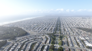
The Sunset District is a neighborhood located in the southwest quadrant of San Francisco, California, United States.

Pacific Palisades is a neighborhood in the Westside region of Los Angeles, California, situated about 20 miles (32 km) west of Downtown Los Angeles.

Grandview Park, also referred to as Turtle Hill by local residents, is a small, elevated park in the Sunset District, San Francisco, California. It is surrounded by 14th and 15th Avenues, as well as Noriega Street.
Zmudowski State Beach is located on Monterey Bay, in Moss Landing, Monterey County, northern California.
Brannan Island State Recreation Area is a state park unit of California, United States, preserving a maze of waterways in the Sacramento–San Joaquin River Delta. The recreation area is located in Sacramento County between Rio Vista and Isleton. This park northeast of San Francisco Bay has countless islands and marshes with many wildlife habitats and many opportunities for recreation, including boating, windsurfing and swimming. The 329-acre (133 ha) park was established in 1952.
Sunset Beach may refer to:

The Lewis and Clark National Historical Park, located in the vicinity of the mouth of the Columbia River, commemorates the Lewis and Clark Expedition. Administration of the park, which includes both federal and state lands, is a cooperative effort of the National Park Service and the states of Oregon and Washington. The National Historical Park was dedicated on November 12, 2004.

Manresa State Beach is a state-protected beach on Monterey Bay near Watsonville in Santa Cruz County, California. Manresa State Beach has two different State owned and operated facilities associated with it: Manresa Main State Beach, and Manresa Uplands State Beach and Campground.

Manchester State Park is a state park of California, United States. It includes 18,000 feet (5,500 m) of protected beachfront on the Pacific Ocean in Northern California on State Route 1, 7 miles (11 km) north of Point Arena. The park features sand dunes, flat grasslands and five miles of gentle, sandy beachfront. The park is noted for steelhead and salmon fishing in the park's two streams, Brush Creek and Alder Creek, as well as the driftwood that collects in the catch basin created by the gently curved coastline. The 5,272-acre (2,134 ha) site was established as a California state park in 1955 and takes its name from Manchester, California, seven miles north of Point Arena.

Monterey Bay Academy (MBA) is a private school in Santa Cruz County, California. It is a part of the Seventh-day Adventist education system, the world's second largest Christian school system.

Shore Acres State Park is a state park 13 miles (21 km) south of Coos Bay in the U.S. state of Oregon. It is one of three state parks along the Cape Arago Highway, which runs along the Pacific Ocean west of U.S. Route 101. Sunset Bay State Park is about 1 mile (1.6 km) north of Shore Acres, and Cape Arago State Park is about a mile south.
Crissey Field State Recreation Site is a state park in the U.S. state of Oregon, administered by the Oregon Parks and Recreation Department. It is the south-westernmost point in the state of Oregon.

Sunset Bay State Park is a state park in the U.S. state of Oregon. Administered by the Oregon Parks and Recreation Department, it is about 0.4 miles (0.6 km) south of Cape Arago Lighthouse and 2.5 miles (4.0 km) outside the town of Charleston on Coos Bay. The park offers a crescent shaped beach, tide pools, hiking trails and a year-round campground.
Sunset Beach State Recreation Site is a state park in Clatsop County, Oregon, United States, administered by the Oregon Parks and Recreation Department. The park comprises 120 acres (49 ha) along the Pacific Ocean on the Clatsop Plains.

Pismo State Beach is a beach on the Pacific coast in the U.S. state of California. It is approximately 17 miles long and fronts the towns of Pismo Beach, Grover Beach, and Oceano in San Luis Obispo County. It is managed by the California Department of Parks and Recreation.
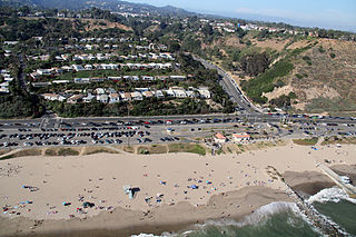
Will Rogers State Beach is a beach park on the Santa Monica Bay, at the Pacific coast of Southern California. Located in the Pacific Palisades neighborhood of Los Angeles, the beach is owned by the California Department of Parks and Recreation; however, it is managed and maintained by the Los Angeles County Department of Beaches and Harbors. A section just south of the intersection of Pacific Coast Highway and Entrada Drive is popular within the LGBT community and is therefore considered Los Angeles' unofficial gay beach; this section is often referred to as Ginger Rogers Beach.

Moss Landing State Beach is a state park on Monterey Bay, in Monterey County, California.

Robert H. Meyer Memorial State Beach is a state beach of California, located in northern Malibu, Southern California.
The park is part of the Santa Monica Mountains National Recreation Area.


