Founded in 1988, the Conservancy has protected 1,600 acres (6.5km2) of open space as nature preserves on the Palos Verdes Peninsula.[1]
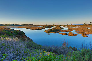
White Point Nature Preserve
The White Point Nature Preserve is located in San Pedro and features 102 acres (0.41km2) of restored coastal sage scrub habitat, hiking and handicap access trails, and a Nature Education Center overlooking the ocean and Santa Catalina Island.
According to the Land Conservancy, White Point Nature Preserve was formerly owned and operated by the US military as a Nike missile site.[3] When the City of Los Angeles purchased the land back, it was designated to the Conservancy in 2000. A 25-year agreement was made with the Conservancy and the City to help restore the native plant species and habitat for both native flora and fauna. The White Point Nature Preserve was established and opened for the public to enjoy its scenery, trails, and education program in 2003.[4]
The White Point Nature Education Center has been constructed from an old missile assembly building and provides visitors with exhibits showcasing the Preserve's rich cultural and ecological history. The site once belonged to the Tongva, an indigenous tribe from the Los Angeles Basin and the Southern Channel Islands.[5] The Education Center highlights the history of the Tongvan people and their importance to the land, and is surrounded by native plant demonstration gardens.
Linden H. Chandler Preserve
The Linden H. Chandler Preserve is a 28.5-acre (115,000m2) property located in Rolling Hills Estates. Owned jointly by the City of Rolling Hills Estates and the Land Conservancy, intensive habitat restoration efforts have added native wildflowers and shrubs to the hillsides.[6] Trails traverse its slopes and grasslands, passing by a recently restored wetland area. The Linden H. Chandler Preserve was created in 1993 through a sale and donation of property by the Chandler heirs, who wanted to see the land preserved in their father's name, who was the founder of Chandler's Palos Verdes Sand and Gravel in Rolling Hills Estates.
George F Canyon Preserve
The 51-acre (21ha) George F Canyon Preserve and Nature Center is owned by the City of Rolling Hills Estates, and operated by the Conservancy. A nature trail passes through one of the largest canyons on the Palos Verdes Peninsula. Visitors walk or ride on horseback through willow-riparian and coastal sage scrub habitats, culminating in a view of the Los Angeles Basin.
The George F Canyon Nature Center provides educational and recreational programs.[7] Exhibits focus on themes such as butterflies, birds of the canyon, insects, plant habitats, animals and wildflowers.
Palos Verdes Nature Preserve
Aerial view of preserved land on the coast
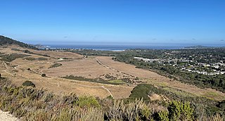
The Palos Verdes Nature Preserve is the largest of the Conservancy's preserves consisting of approximately 1,400 acres (5.7km2) of rolling hills, steep canyons and rock outcrops, with natural habitat and views of the Pacific Ocean and Santa Catalina Island. The City of Rancho Palos Verdes owns most of the land and the Palos Verdes Peninsula Land Conservancy manages the preserve.[8] The preserve is made up of 12 reserves: Malaga Reserve, Vista Del Norte Reserve, Vicente Bluffs Reserve, Alta Vicente Reserve, Three Sisters Reserve, Filiorum Reserve, Portuguese Bend Reserve, Ocean Trails Reserve, Abalone Cove Ecological Reserve, Forrestal Reserve, San Ramon Reserve, and Agua Amarga Reserve.[9]
Malaga Reserve
Malaga Canyon stretches the 61.5 acres of the Malaga Reserve. Running up the Grandview neighborhood of the Palos Verdes Estates, the reserve was acquired by the conservancy in 2019. The land now serves as habitat for the rare California gnatcatcher and is potential habitat for the Palos Verdes Blue Butterfly. The reserve is also part of the popular hiking circuit, the "PV Malaga Cove Loop" which is a 6.1 mile loop encompassing the Malaga Estates and Malaga Cove. Coastal sages, coastal cacti, and flowering blooms occupy the entirety of the land.
Vista Del Norte Reserve
Vista Del Norte Reserve is the smallest of the Palos Verdes Nature Preserves at only 14 acres. It is located above Indian Peak Drive on the slopes of the Rolling Hills Estates. It overlooks the Peninsula's center area from Vista del Norte and Indian Peak Loop Trails. Hiking trails are open to pedestrians only and offer views of the LA Basin and the Catalina Islands on a clear day.
Vicente Bluffs Reserve
This reserve occupies the bluffs located off the coast of the eastern edge of Rancho Palos Verdes. It encompasses 84 acres of accessible land: 6 acres of the bluffs at the lower point of the reserve, 9 acres of fishing access property, and the areas of natural habitat within the Estates at 69 acres. This particular reserve is known for its unique geological formations, such as the hexagonal-shaped rock columns of basalt. The California Coastal Conservancy grant, along with the Conservancy help protect these formations from sedimentation and increased erosion from hiking and other recreational activities.
The three parts of the reserve are separated by chunks of private land, so there is no singular trail that runs through the entirety of the reserve. Because the bluffs and the rock formations are protected by the Conservancy, trails running through this section are designated for pedestrian use only, and the land located more inland have multi-use purposes.
Alta Vicente Reserve
Like Vicente Bluffs Reserve, Alta Vicente Reserve is located along the eastern shore of Rancho Palos Verdes, and encompasses a coastal section and a more inland section. A mass restoration plan was initiated in 2008 to restore the 55 acre reserve, and efforts are still being made today to accomplish this goal. There are several trails, whose purpose is multi-use, that occupy the inland section, and due to increased protection of the coast, the coastal section is designated for pedestrian hiking only.
In 1942, at the beginning of World War II, the land that now stands at this reserve was utilized by the US in its efforts to protect the western shore from enemy advancement tactics. Two 6-inch diameter coastal artillery guns were constructed to protect the Catalina channel from invasion, and several bunkers were dug out to house soldiers, ammunition, and supplies.[10]
Three Sisters Reserve
Three Sisters Reserve connects to the western edge of Filiorum Reserve, and is a 99 acre piece of protected land that can be accessed directly from Fillorum Reserve or through the Rolling Hills Estates. A 21 acre restoration project was initiated in 2009 to help restore native wildflower habitat and coastal habitat.
The innovative technique used in this project was the monitoring of 250 goats, which were moved into the reserve to eat all of the non-native plants and species of weeds that had taken over the ecosystem when the preserve was originally established. The Conservancy is also responsible for the irrigation and planting of over 8,000 grass and sage scrub species. Because of these efforts, the reserve can support rare bird species and multi-use trails.
Filiorum Reserve
This reserve is situated between Three Sisters Reserve and Portuguese Bend Reserves, and can be accessed from either of the two reserves or through residential street access. This 191 acres of land was acquired by Rancho Palos Verdes in December of 2009, and later designated to the Conservancy. The acquisition of this land became a team effort, as the City and Conservancy brought forward 6.5 million in capital, and over 700 local donors raised the other portion of the fund in order to purchase this land for the City and the local population.
Portuguese Bend Reserve
Portuguese Bend Reserve is the largest individual reserve within the Palos Verdes Nature Preserve at 399 acres. It situated in between Filiorum Reserve and Forrestal Reserve, and was preserved by the Conservancy in 2005. The reserve consists of Rolling Hills, 5 distinct canyons and rock outcrops, and an ecosystem of incredibly drought-resistant flowering shrubs and coastal sagebrush.
In August 2009, a California wildfire burned through 165 acres of the reserve, affecting the flora and fauna species within the land, including the endangered California Gnatcatcher. Because of this, restoring this reserve became a primary goal for the Conservancy, and planting and restoration projects continue to this day.
Portuguese Bend has a long history of recorded landslides, with its latest movement episode beginning in 1956 from a road construction project. By 1969, the stretch of land had lost about 54,500,000 metric tons of debris to landslide, and the site has been continuing to erode to this day.[11] As a result, some portions of the trails or reserve will be flagged by cones or caution tape, and some sections are off-limits to everybody in general.
Ocean Trails Reserve
Located directly below San Ramon Reserve, and stretching along the coast, parallel to Trump National Golf Club, Los Angeles, lies the 119 acre Ocean Trails Reserve. The reserve has a recorded 8 miles of pedestrian trails, including several beach access points. Over 250,000 native plants have been restored throughout the reserve, including several species of coastal scrub, cacti, and grasses. The area provides a hotspot for migrating birds flying both North and South depending on the time of year, and the habitat supports local species like the California gnatcatcher and the Cactus wren.
Abalone Cove Ecological Reserve
Abalone Cove Ecological Reserve is a 64 acre preserve that also contains a State Ecological Preserve. It is separated into two beaches, Abalone Cove and Sacred Cove, and features tide pools, bluffs, and black sand. Accessible along Palos Verdes Drive South, the reserve maintains coastal marine species as well as the terrestrial native species, therefore fishing or taking of marine species is strictly prohibited. Several trails run throughout the reserve, whether you want to make it down to the beaches and tidepools, or if you want to enjoy the scenery from along the cliffs. Currently, some parts of the reserve are closed off to the public due to landslides and unstable cliffs above the site. The area will remain closed until these issues is resolved.
From an ecology perspective, the word take generally means to harass, harm, pursue, hunt, shoot, wound, kill, trap, capture, or collect, or to attempt to engage in any such conduct with a species, as mentioned in the Endangered Species Act.[12]
Forrestal Reserve
Connecting to the Southeastern end of the Portuguese Bend Reserve is the 155 acres of Forrestal Reserve. This reserve has played a prominent role in the Conservancy's efforts to restoring the land. In 2001, restoration began with the help of local community volunteers, so today the reserve can be considered as the best remaining area for wildlife habitat and hiking trails. within the entirety of the Palos Verdes Nature Preserve.
According to the site's geologic history, Rancho Palos Verdes was once an island, and the LA Basin was submerged underwater. Once tectonic uplift took place, the crust, once submerged, began to form cliffs above sea level, and the material within the crust rose along with it.[13] This being said, the reserve's main unique features include the presence of a quarry, dramatic cliffs characterized by faults and folds, and crystals and fossils buried within the sedimentary bedding and igneous intrusions. The discovered fossil remnants can be found at the Point Vicente Interpretive Center.
San Ramon Reserve
The San Ramon Reserve is situated directly above the eastern portion of the Ocean Trails Reserve. Formerly known as the "Switchbacks", it includes all of the 95-acre parcels that surround the switchbacks of Palos Verdes Drive East. The preserve provides oceanside views of the harbor and Catalina Island.
Agua Amarga Reserve
The Agua Amarga Reserve is a 59-acre reserve that features two canyons, the Agua Amarga and the Lunada, which conjoin on the western end of the reserve. The site is on the border of residential Palos Verdes Estates and can be seen below Hawthorne Boulevard. The Agua Amarga Canyon was acquired in 2005, but land rights to the Lunada Canyon were given to the Conservancy by the E.K Zuckerman family in 1992, which became the Land Conservancy's first natural area.
Once a site for residential development, the Conservancy has restored three acres of coastal sage scrub and willow wetlands habitat for native species such as the California gnatcatcher. Lunada Canyon is a popular hiking destination with scenic views of the ocean from within the gully of the canyon. A hike through Lunada is 1.5 miles round trip, excluding the 0.2 miles of overgrown vegetation at the top of the trail where the views are blocked by nearby houses.[14]
The Defense Fuel Supply Point in San Pedro provides storage for military fuel reserves and is also home to the endangered Palos Verdes blue butterfly (Glaucopsyche lygdamus palosverdesensis), the “rarest butterfly on earth”. The DFSP mission is a restricted facility which receives, stores, and distributes diesel and jet fuels for military use in California, Arizona and Nevada. Coastal sage scrub is juxtaposed within pipelines and storage tanks, providing habitat for the Palos Verdes blue butterfly as well as the threatened California gnatcatcher (Polioptila californica), a small gray bird that is listed as threatened by the U.S. Fish and Wildlife Service.
The Conservancy works to save the landscape from past degradation from urbanization, agriculture uses, and the introduction of invasive foreign species. The goals of the Conservancy's science program are to increase the scientific knowledge base of the Palos Verdes Peninsula through collaborative research. The scientific program focuses on understanding the basic ecosystem functions that define the Palos Verdes Peninsula. Research is conducted both by Conservancy staff and through partnerships with universities, colleges and local agencies.
Research projects inform restoration, conservation, education, and stewardship programs and address the interface between the natural and urban environments. The Conservancy's research program was developed to involve collaborative researchers with the overall goal of increasing the scientific knowledge of the Palos Verdes Peninsula.
Today, the Conservancy implores several educational opportunities for the community to join in on. A team of environmental educators lead monthly nature walks for those interested in learning about the history of the land and how to properly maintain the natural environment. They also host several events throughout the year for families, and they are always open to bookings for school trips and other program visits. The Conservancy has two nature centers where everyone is able to learn about the land and participate in an array of activities to inspire connection to nature, George F. Canyon Nature Preserve and White Point Nature Education Center.[15]
Palos Verdes Estates is a coastal city in Los Angeles County, California, United States, situated on the Palos Verdes Peninsula and neighboring Rancho Palos Verdes and Rolling Hills Estates. The city was master-planned by the noted American landscape architect and planner Frederick Law Olmsted Jr. The city is located along the Southern California coastline of the Pacific Ocean.
The Palos Verdes blue is a small endangered butterfly native to the Palos Verdes Peninsula in southwest Los Angeles County, California, United States. As its distribution has been proven to be limited to one single site it has one of the best claims to being the world's rarest butterfly.
Fitzgerald Marine Reserve is a marine reserve in California on the Pacific Ocean, located just north of Pillar Point Harbor and Mavericks in the San Mateo County community of Moss Beach. Moss Beach is located approximately 20 miles (32 km) south of San Francisco and 50 miles (80 km) north of Santa Cruz. The reserve is a 32-acre (0.13 km2) holding which extends from Montara light station at the north to Pillar Point on the south. The reserve consists of a three-mile stretch of beach, tidepool habitat, marsh, erosive bluffs, clifftop trail and cypress and eucalyptus forests. The property is owned by the State of California and managed by San Mateo County as a county park and nature preserve. The reserve is administratively assigned to be part of the Monterey Bay National Marine Sanctuary. Adjacent to and possibly within the reserve is an endangered species of butterfly, the San Bruno elfin butterfly.
The Palos Verdes Peninsula is a peninsula and sub-region of the Los Angeles metropolitan area, located within southwestern Los Angeles County in the U.S. state of California. Located in the South Bay region, the peninsula contains a group of cities in the Palos Verdes Hills, including Palos Verdes Estates, Rancho Palos Verdes, Rolling Hills and Rolling Hills Estates, as well as the unincorporated community of Westfield/Academy Hill. The South Bay city of Torrance borders the peninsula on the north, the Pacific Ocean is on the west and south, and the Port of Los Angeles is east. As of the 2010 Census, the population of the Palos Verdes Peninsula is 65,008.
The Northern California coastal forests are a temperate coniferous forests ecoregion of coastal Northern California and southwestern Oregon.
The Upper Las Virgenes Canyon Open Space Preserve is a large open space nature preserve owned and operated by the Santa Monica Mountains Conservancy spanning nearly 3,000 acres (1,200 ha) in the Simi Hills of western Los Angeles County and eastern Ventura County.
The Santa Monica Mountains National Recreation Area is a United States national recreation area containing many individual parks and open space preserves, located primarily in the Santa Monica Mountains of Southern California. The SMMNRA is in the greater Los Angeles region, with two thirds of the parklands in northwest Los Angeles County, and the remaining third, including a Simi Hills extension, in southeastern Ventura County.
The Santa Rosa and San Jacinto Mountains National Monument is a National Monument in southern California. It includes portions of the Santa Rosa and San Jacinto mountain ranges, the northernmost ones of the Peninsular Ranges system. The national monument covers portions of Riverside County, west of the Coachella Valley, approximately 100 miles (160 km) southeast of downtown Los Angeles.
The Back Bay is the colloquial term for the inland delta in Newport Beach, California. It connects the Upper Newport Bay with the Newport Harbor. It is a nature reserve home to several species of birds with hiking and biking trails. The bay is recognized for protection by the California Bays and Estuaries Policy.
Aliso and Wood Canyons Wilderness Park is a major regional park in the San Joaquin Hills of Orange County, California in the United States. Comprising 4,500 acres (1,800 ha) of rugged coastal canyons, open grassland, and riparian woodland, the park borders the suburban cities of Aliso Viejo, Dana Point, Laguna Beach, Laguna Hills and Laguna Niguel and lies within a portion of the ancestral homeland of the indigenous Acjachemen people.
The Palos Verdes Hills are a low mountain range on the southwestern coast of Los Angeles County, California. They sit atop the Palos Verdes Peninsula, a sub-region of the Los Angeles metropolitan area.
San Elijo Lagoon Ecological Reserve is one of the largest remaining coastal wetlands in San Diego County, California, United States.
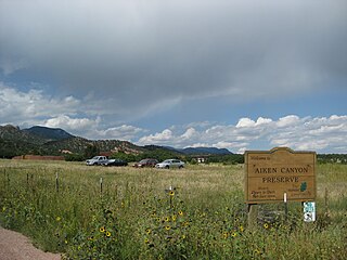
Aiken Canyon Preserve is a 1,621-acre (6.56 km2) Nature Conservancy-managed state property in Colorado. It was first observed and named after Charles Aiken, a 19th-century U.S. surveyor, pioneer, and ornithologist who first surveyed the region in the 1870s and identified more than 75 bird species. The preserve consists of foothills, shrub and woodland ecosystems and is 12.4 miles (20.0 km) southeast from Colorado Springs located on the eastern slope of the Rampart Range which is within a smaller foothill system of the Front Range. The surrounding mountain ranges of the Rampart Range and Palmer Divide created the nature preserves sustainable ecosystem. There is also a four-mile (6 km)-loop hiking trail on the preserve.
San Diego National Wildlife Refuge is a National Wildlife Refuge in California. It is part of the San Diego National Wildlife Refuge Complex. A variety of habitats from coastal sage scrub and chaparral to oak woodland and freshwater marsh describe this inland refuge in San Diego's backcountry.
Laguna Coast Wilderness Park is a 7,000-acre (2,800 ha) wilderness area in the San Joaquin Hills surrounding Laguna Beach, California. This park features coastal canyons, ridgeline views and the only natural lakes in Orange County, California. Trails are maintained for hiking and mountain biking with a wide range of difficulty, from beginner to expert. Most trails gain in height, reaching a maximum of 1,000 feet (300 m) in elevation. Several trails lead to downtown Laguna Beach.
Peters Canyon Regional Park is a regional park within the Orange County Regional Parks System in California. The park contains 354 acres of southern California wildlife, including coastal sage shrub, riparian, freshwater marsh, and grasslands, and is located within the boundaries of both Orange, California and Tustin, California. Peters Canyon was given to this city in 1992 by the Irvine Company who had used it previously for cattle grazing. The canyon is lined with a residential area on one side and open hills on the other. This canyon is commonly used by hikers, mountain bikers, and equestrians because of the trails that circumvent the 50 acre man-made lake, which was constructed by the Irvine Company in 1931, on the interior of the plot. The regional park is open from 7:00 AM to sunset every day of the week, save for the chance of rain or hazardous conditions, in which case the park will be closed for three days following the particular occurrence.
Arroyo Conejo Open Space is a 302-acre (122 ha) open space reserve in the western Simi Hills in northern Newbury Park, Ventura County, California. Most of it is part of the 250-acre (100 ha) Arroyo Conejo Nature Preserve.
The Big Sur Land Trust is a private 501(c)(3) non-profit located in Monterey, California, that has played an instrumental role in preserving land in California's Big Sur and Central Coast regions. The trust was the first to conceive of and use the "conservation buyer" method in 1989 by partnering with government and developers to offer tax benefits as an inducement to sell land at below-market rates. Since 1978, with the support of donors, funders and partners, it has conserved over 40,000 acres through conservation easements, acquisition and transfer of land to state, county and city agencies. It has placed conservation easements on 7,000 acres and has retained ownership of over 4,000 acres.
The Palo Corona Regional Park is a 4,500 acres (1,800 ha) park owned by the Monterey Peninsula Regional Park District on land east of Big Sur Coast Highway and Garrapata State Park in California. The 9,898 acres (4,006 ha) property stretches southeast about 11 miles (18 km) from the near the Carmel River State Beach to the Los Padres National Forest. The park is long from north to south, bordered on the northwest by Highway 1 and across from Carmel River State Beach. It wraps around Point Lobos Ranch and abuts Santa Lucia Preserve to the east. In the middle, it is sandwiched by Mitteldorf Preserve and Garrapata State Park. Its southern border abuts Joshua Creek Canyon Ecological Reserve. Environmental interests were concerned that it would be converted to an estate-type development like that done for Rancho San Carlos. In May 2002, the Big Sur Land trust and The Nature Conservancy joined to buy the Ranch. Overall, the park directly and indirectly connects nine conservation properties preserved for their biological, recreation and scenic values. The area includes the former Rancho Caňada Country Club and golf course in Carmel Valley.
Pillar Point Bluff is a 220-acre park (89 ha) in San Mateo County, California. It is part of the Fitzgerald Marine Reserve, owned by the U.S. state of California, and managed by San Mateo County as a county park and nature preserve. The park is located between Princeton-by-the-Sea and Moss Beach, just north of the Pillar Point peninsula, Pillar Point Harbor, and Half Moon Bay. The area was inhabited by coastal indigenous peoples for thousands of years, and in recent centuries, was used for livestock grazing by Spanish Missions and Mexican ranchos. Pillar Point Bluff was once part of the Rancho Corral de Tierra Mexican land grant before California became a state.
Wikimedia Commons has media related to Palos Verdes.
This page is based on this Wikipedia article Text is available under the CC BY-SA 4.0 license; additional terms may apply. Images, videos and audio are available under their respective licenses.