Imperial County is a county located on the southeast border of the U.S. state of California. As of the 2020 census, the population was 179,702, making it the least populous county in Southern California. The county seat and largest city is El Centro. Imperial is the most recent California county to be established, as it was created in 1907 out of portions of San Diego County.

San Bernardino County, officially the County of San Bernardino, is a county located in the southern portion of the U.S. state of California, and is located within the Inland Empire area. As of the 2020 U.S. Census, the population was 2,181,654, making it the fifth-most populous county in California and the 14th-most populous in the United States. The county seat is San Bernardino.

The Imperial Valley of Southern California lies in Imperial and Riverside counties, with an urban area centered on the city of El Centro. The Valley is bordered by the Colorado River to the east and, in part, the Salton Sea to the west. Farther west lies the San Diego and Imperial County border. To the north is the Coachella Valley region of Riverside County, which together with Imperial Valley form the Salton Trough, or the Cahuilla Basin, also the county line of Imperial and Riverside counties, and to the south the international boundary with Mexico.

The Chocolate Mountains of California are located in Imperial and Riverside counties in the Colorado Desert of Southern California. The mountains stretch more than 60 miles (100 km) in a northwest to southeast direction, and are located east of the Salton Sea and south and west of the Chuckwalla Mountains and the Colorado River. To the northwest lie the Orocopia Mountains.

The San Gorgonio Wilderness is located in the eastern San Bernardino Mountains, in San Bernardino County and into northern Riverside County, Southern California.
The Chuckwalla Mountains are a mountain range in the transition zone between the Colorado Desert—Sonoran Desert and the Mojave Desert, climatically and vegetationally, in Riverside County of southern California.
The Big Maria Mountains are located in the southeastern part of the U.S. state of California, near the Colorado River and Arizona. The range lies between Blythe and Vidal, and west of U.S. Route 95 in California and east of Midland. The mountains are home to the Eagle Nest Mine and reach an elevation of 1,030 m (3,380 ft). A power line that runs from Parker Dam to Yuma, Arizona runs through the range. A smaller range, the Little Maria Mountains, lie to the west of the Big Marias.
The Palen Mountains are located in the southern Mojave Desert – northern Colorado Desert in eastern Riverside County, California, US. The range lies southeast of the Coxcomb Mountains, and northeast of the Chuckwalla Mountains near Interstate 10. The mountains lie in a southwest-northeasterly direction and are approximately 15 miles long and nine miles wide at their widest point.

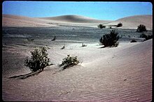
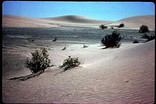
The Algodones Dunes is a large sand dune field, or erg, located in the southeastern portion of the U.S. state of California, near the border with Arizona and the Mexican state of Baja California. The field is approximately 45 miles (72 km) long by 6 miles (9.7 km) wide and extends along a northwest-southeast line that correlates to the prevailing northerly and westerly wind directions. The name "Algodones Dunes" refers to the entire geographic feature, while the administrative designation for that portion managed by the Bureau of Land Management is the Imperial Sand Dunes Recreation Area. In 1966, Imperial Sand Hills was designated as a National Natural Landmark by the National Park Service. The Algodones Dunes are split into many different sections. These sections include Glamis, Gordon's Well, Buttercup, Midway, and Patton's Valley. Although the Arabic-derived Spanish word algodones translates to "cotton plants", the origin of the toponym is unknown.

The Santa Rosa and San Jacinto Mountains National Monument is a National Monument in southern California. It includes portions of the Santa Rosa and San Jacinto mountain ranges, the northernmost ones of the Peninsular Ranges system. The national monument covers portions of Riverside County, west of the Coachella Valley, approximately 100 miles (160 km) southeast of downtown Los Angeles.
The Piper Mountain Wilderness is a federally designated wilderness area located in the White Mountains 20 miles (32 km) northeast of Big Pine, California in Inyo County, California.
The Sylvania Mountains Wilderness is a federally designated wilderness area located 30 miles (48 km) east of Bishop in the state of California. The wilderness is 18,677acres in size and is managed by the Bureau of Land Management (BLM). The California Desert Protection Act of 1994 created the Sylvania Mountains Wilderness and was added to the National Wilderness Preservation System. The wilderness is bordered by Nevada stateline on the east, Piper Mountain Wilderness on the west and Death Valley National Park to the south.
The Arica Mountains are a small mountain range in northern Riverside County, California. The range lies along the south edge of Rice Valley 6.2 miles (10.0 km) southwest of the old Rice townsite on California State Route 62. They lie 6 miles (9.7 km) north of the Little Maria Mountains and 9 miles (14 km) southwest of the Turtle Mountains. The Granite Mountains lie about 8 miles to the west. They are in the Colorado Desert, in the Lower Colorado River Valley region. They are north the Palen Mountains and Big Maria Mountains; and northwest of Blythe, California.

The Riverside Mountains are a mountain range in Riverside County, California. The town of Vidal, California is located in the West Riverside Mountains.

Riverside County is a county located in the southern portion of the U.S. state of California. As of the 2020 census, the population was 2,418,185, making it the fourth-most populous county in California and the 10th-most populous in the United States. The name was derived from the city of Riverside, which is the county seat.

The Palo Verde Valley is located in the Lower Colorado River Valley, next to the eastern border of Southern California with Arizona, United States. It is located on the Colorado Desert within the Sonoran Desert south of the Parker Valley. Most of the valley is in Riverside County, with the southern remainder in Imperial County. La Paz County borders to the east on the Colorado River.

Mojave Trails National Monument is a large U.S. National Monument located in the state of California between Interstates 15 and 40. It partially surrounds the Mojave National Preserve. It was designated by President Barack Obama on February 12, 2016, along with Castle Mountains National Monument and Sand to Snow National Monument, also in southern California. It is under the administration of the Bureau of Land Management.

Sand to Snow National Monument is a U.S. National Monument located in San Bernardino County and northern Riverside County, Southern California.
The Rice Valley is a valley of the southeastern Mojave Desert, located within Riverside County, California.
Cadiz Dunes Wilderness is a protected wilderness area in the Mojave Trails National Monument in San Bernardino County, California. Established in 1994 by the U.S. Congress, the area is managed by the Bureau of Land Management. This wilderness area is north of Joshua Tree National Park, Sheephole Valley Wilderness lies to the west, Old Woman Mountains Wilderness to the east. The dunes of Cadiz Dunes were formed by blowing sands from the Cadiz dry lake, all located in the Cadiz Valley between the Calumet Mountains and the Old Woman Mountains. The ecology is typical of the Mojave Desert with wildlife that includes coyote, black-tailed jackrabbits, ground squirrels, kangaroo rats, quail, roadrunners, and rattlesnakes. The area is known for a brilliant display of springtime desert wildflowers including the Borrego milkvetch.