
Goat Rock Beach is a sand beach in northwestern Sonoma County, California, United States. This landform is a sub-unit of Sonoma Coast State Beach, owned and managed by the State of California. At the northern terminus of Goat Rock Beach is the mouth of the Russian River, and the southern end of this crescent shaped expanse is the massive Goat Rock, an iconic outcrop of the Sonoma Coast, which is barely attached to the mainland by a narrow isthmus.
Gerstle Cove State Marine Reserve (SMR) is a marine protected area that lies onshore from Salt Point State Park, within the Salt Point State Marine Conservation Area, in Sonoma County on California’s north central coast. The marine protected area covers 0.1 square miles. Gerstle Cove SMR prohibits the take of all living resources.
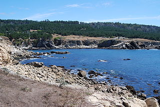
Sea Lion Cove State Marine Conservation Area (SMCA) is a marine protected area that lies onshore, just south of Point Arena in Mendocino County on California’s north central coast. The marine protected area covers 0.22 square miles. Sea Lion Cove SMCA prohibits the commercial and recreational take of invertebrates, algae and other plants, but allows the take of all other species.

Saunders Reef State Marine Conservation Area (SMCA) is a marine protected area that extends offshore, just south of Schooner Gulch State Beach and north of Sail Rock in Mendocino County on California's north central coast. The marine protected area covers 9.35 square miles (24.2 km2). Saunders Reef SMCA prohibits the take of all living marine resources, except the commercial and recreational take of salmon by trolling and the commercial take of urchin.

Stewarts Point State Marine Reserve (SMR) and Stewarts Point State Marine Conservation Area (SMCA) are two adjoining marine protected areas that extend offshore from about a mile south of Black Point to Fisk Mill Cove, in Sonoma County on California’s north central coast. The marine protected areas cover 25.22 square miles (65.3 km2). Stewarts Point SMR prohibits the take of all living marine resources. Stewarts Point SMCA prohibits the take of all living marine resources, except recreational shore based take of marine aquatic plants, marine invertebrates, finfish by hook and line, surf smelt by beach net, and species authorized by Title 14 Section 28.80 by hand-held dip net.
Estero Americano State Marine Recreational Management Area (SMRMA) is a marine protected area that splits Sonoma and Marin counties on California’s north central coast. The marine protected area covers 0.15 square miles. Estero Americano SMRMA prohibits the take of all living marine resources, except the recreational hunting of waterfowl, unless otherwise restricted by hunting regulations.

Duxbury Reef State Marine Conservation Area (SMCA) is a marine protected area located about 1 mile (2 km) west of Bolinas in Marin County on California’s north central coast. This marine protected area covers 0.66 square miles (1.7 km2). Duxbury Reef SMCA prohibits the take of all living marine resources, except the recreational take of finfish from shore only and the recreational take of abalone.

Estero de San Antonio State Marine Recreational Management Area (SMRMA) is a marine protected area 1.5 miles north of Dillon Beach in Marin County on California’s north central coast. The marine protected area covers 0.09 square miles. Estero de San Antonio SMRMA prohibits the take of all living marine resources, except the recreational hunting of waterfowl, unless otherwise restricted by hunting regulations.
Salt Point State Marine Conservation Area (SMCA) is a marine protected area that lies onshore from Fisk Mill Cove and south along Salt Point State Park in Sonoma County on California's north central coast. The marine protected area covers 3.12 square miles (8.1 km2). Salt Point SMCA prohibits the take of all living marine resources, except the recreational take of abalone and finfish.
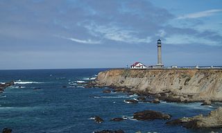
Point Arena State Marine Reserve (SMR) and Point Arena State Marine Conservation Area (SMCA) are two adjoining marine protected areas that extend offshore of Point Arena in Mendocino County on California’s north central coast. The combined area of these marine protected areas is 11.11 square miles (28.8 km2), with 4.38 square miles (11.3 km2) in the SMR and 6.73 square miles (17.4 km2) in the SMCA. Point Arena SMR prohibits the take of all living marine resources. Point Arena SMCA prohibits the take of all living marine resources, except commercial and recreational salmon trolling.

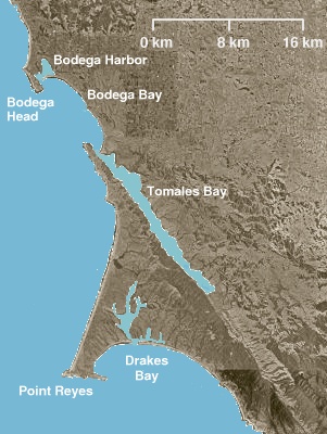
Bodega Head State Marine Reserve (SMR) and Bodega Head State Marine Conservation Area (SMCA) are two adjoining marine protected areas off Bodega Bay in Sonoma County on California’s north-central coast. The combined area of these marine protected areas is 21.64 square miles (56.0 km2), with 9.3 square miles (24 km2) in the SMR, and 12.34square miles in the SMCA. Bodega Head SMR prohibits the take of all living marine resources. Bodega Head SMCA prohibits the take of all living marine resources, except the recreational and commercial take of pelagic finfish with troll fishing gear or seine, Dungeness crab by trap, and market squid by hand-held dip net and round haul net.
Point Reyes State Marine Reserve (SMR) and Point Reyes State Marine Conservation Area (SMCA) are two adjoining marine protected areas that extend offshore of Point Reyes Headlands and within Drakes Bay in Marin County on California’s north central coast. The combined area of these marine protected areas is 21.49 square miles, with 9.38 in the SMR, and 12.11 in the adjacent SMCA. Point Reyes SMR prohibits the take of all living marine resources. Point Reyes SMCA prohibits the take of all living marine resources, except the recreational and commercial take of Dungeness crab by pot and salmon by trolling.

Cambria State Marine Conservation Area (SMCA) is a marine protected area located off the coast of the city of Cambria, California on California’s central coast in San Luis Obispo County, California. The marine protected area covers 6.26 square miles (16.2 km2). Within the SMCA recreational fishing and take is allowed while commercial fishing and take of all living marine resources is prohibited.

Edward F. Ricketts State Marine Conservation Area is one of four small marine protected areas located near the cities of Monterey and Pacific Grove, at the southern end of Monterey Bay on California’s central coast. The four areas together encompass 2.96 square miles (7.7 km2). Within SMCAs fishing and take of all living marine resources is prohibited except the recreational take of finfish by hook-and-line and the commercial take of giant and bull kelp under certain conditions.

Greyhound Rock State Marine Conservation Area (SMCA) is one of two adjoining marine protected areas off the coast of San Mateo County and Santa Cruz County, on California's central coast. The area is approximately 55 miles (89 km) south of San Francisco. The SMCA is 11.81 square miles (30.6 km2). Within the SMCA fishing and take of all living marine resources is prohibited except the recreational take of giant kelp, squid, salmon, and other finfish, subject to various conditions. Also permitted is the commercial take of giant kelp, salmon, and squid, subject to various conditions.
San Diego-Scripps Coastal Marine Conservation Area (SMCA) and Matlahuayl State Marine Reserve (SMR) are adjoining marine protected areas that extend offshore from La Jolla in San Diego County on California's south coast. The two marine protected areas cover 2.51 square miles (6.5 km2). San Diego-Scripps Coastal SMCA prohibits the take of all living marine resources except that coastal pelagic species, not including market squid, may be taken recreationally by hook and line. Matlahuayl SMR prohibits the take of all living marine resources.

Crystal Cove State Marine Conservation Area (SMCA) is one of a cluster of four adjoining marine protected areas that extend offshore of Newport Beach in Orange County on California’s south coast. The SMCA covers 3.45 square miles of near shore waters. Crystal Cove protects marine life by limiting the removal of marine wildlife from within its borders, including tide pools. Take of all living marine resources is prohibited except: recreational take of finfish by hook-and-line or by spearfishing, and lobster and sea urchin is allowed. Commercial take of coastal pelagic species by round haul net, spiny lobster by trap, and sea urchin is allowed.
Dana Point State Marine Conservation Area
Tijuana River Mouth State Marine Conservation Area (SMCA) is a marine protected area that extends offshore of southern San Diego County on California's south coast. The SMCA covers 2.91 square miles (7.5 km2).
Upper Newport Bay State Marine Conservation Area (SMCA) is a marine protected area in Newport Bay in Orange County and the South Coast region of Southern California. It extends inland/northeast from the Pacific Coast Highway crossing of the bay, within the city of Newport Beach.
