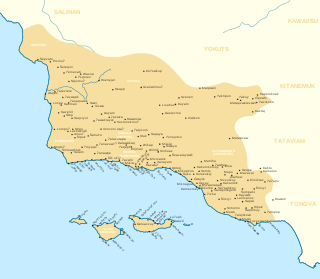
The Chumash are a Native American people of the central and southern coastal regions of California, in portions of what is now Kern, San Luis Obispo, Santa Barbara, Ventura and Los Angeles counties, extending from Morro Bay in the north to Malibu in the south to Mt Pinos in the east. Their territory includes three of the Channel Islands: Santa Cruz, Santa Rosa, and San Miguel; the smaller island of Anacapa was likely inhabited seasonally due to the lack of a consistent water source.

Morro Bay is a seaside city in San Luis Obispo County, California. Located on the Central Coast of California, the city population was 10,757 as of the 2020 census, up from 10,234 at the 2010 census. The town overlooks Morro Bay, a natural embayment with an all-weather small craft commercial and recreational harbor.

Baywood-Los Osos is an unincorporated community in western San Luis Obispo County, California. The population was 14,351 in the 2000 census. It includes the communities of Los Osos, which is located near Morro Bay, Baywood Park, and the former community of Cuesta-by-the-Sea.

The Central Coast is an area of California, roughly spanning the coastal region between Point Mugu and Monterey Bay. It lies northwest of Los Angeles and south of the San Francisco Bay Area, and includes the rugged, rural, and sparsely populated stretch of coastline known as Big Sur.

The Santa Monica Mountains are a coastal mountain range in Southern California, next to the Pacific Ocean. It is part of the Transverse Ranges. The Santa Monica Mountains National Recreation Area encompasses this mountain range. Because of its proximity to densely populated regions, it is one of the most visited natural areas in California.

Cerro Cabrillo, also known locally as Cabrillo Peak, is a rocky mountain in eastern Morro Bay State Park, San Luis Obispo County, central California.

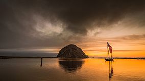
Morro Rock is a volcanic plug in Morro Bay, California, on the Pacific Coast at the entrance to Morro Bay harbor. A causeway connects it with the shore, making it a tied island. The rock is protected as the Morro Rock State Preserve.

Los Osos is an unincorporated town in San Luis Obispo County, California, United States. Located on the Central Coast of California, Los Osos had a reported population of 14,465 in 2020. For statistical purposes, the United States Census Bureau has defined Los Osos as a census-designated place (CDP).

Montaña de Oro is a state park in Central Coastal California, six miles southwest of Morro Bay and two miles south of Los Osos.

Hearst San Simeon State Park is a state park of California, United States, preserving rocky coast and rare habitats. It is located between Cambria and San Simeon. The 3,409-acre (1,380 ha) park was first established in 1932. The park includes the Santa Rosa Creek Natural Preserve, the San Simeon Natural Preserve and the Pa-nu Cultural Preserve, which were established in 1990.

Estero Bluffs State Park is a state park of California, United States, on Estero Bay. The park protects a grassland-dominated marine terrace that slopes from California State Route 1 to the Pacific Ocean. The property is crossed by San Geronimo and Villa Creeks and is just north of the town of Cayucos. The 353-acre (143 ha) park was established in 2000.

Morro Strand State Beach is a protected beach within California's state park system located in north Morro Bay along California State Route 1. Morro Strand is a popular coastal frontage park on Estero Bay featuring the Morro Strand Trail and picnic sites. A three-mile stretch of beach connects the southern and northern entrances to the beach. Dogs are prohibited in part due to the nesting and protection of the Western Snowy Plover. Fishing, surfing, beach walking, and jogging are popular activities.

Los Osos Oaks State Natural Reserve is a California State Park in western San Luis Obispo County, in the Central Coast of California region. It preserves centuries-old coast live oaks growing atop relict sand dunes. It is located in the Los Osos Valley between San Luis Obispo and Baywood Park-Los Osos, just outside the town of Los Osos. The 85-acre (34 ha) park was established in 1972.

The Los Osos Valley is a valley within San Luis Obispo County, in the Central Coast of California region.
Morro Creek is a coastal stream in San Luis Obispo County, in the central region of the U.S. state of California. The watercourse flows from the Santa Lucia Mountains to discharge into the Pacific Ocean, at its mouth on Estero Bay, near the city of Morro Bay.

The Elfin Forest Natural Area is a nature preserve protecting a unique plant community in Los Osos-Baywood Park, San Luis Obispo County, central California. It consists of prehistoric sand dunes, rising 150 feet (46 m) above southern Morro Bay, on the north of Los Osos-Baywood Park.
Los Osos Back Bay is a prehistoric Chumash archaeological site in the Los Osos Valley, near the coast in San Luis Obispo County, California.

Morro Bay State Marine Recreational Management Area (SMRMA) and Morro Bay State Marine Reserve (SMR) are two marine protected areas that provide protection for Morro Bay Estuary on California's central coast. The two marine protected areas together encompass 3.31 square miles (8.6 km2). The SMR protects all marine life within its boundaries. Fishing and take of any living marine resources is prohibited. nWithin the SMRMA, fishing or taking any living marine resources is prohibited with the exception that, with a valid state water bottom lease and permit, the recreational taking of finfish and the aquaculture of oysters is permitted north of latitude 35° 19.70′ N. Recreational hunting of waterfowl is allowed unless otherwise restricted by hunting regulations.
Satwiwa was a former Chumash village in the Santa Monica Mountains of Newbury Park, California. The current Satwiwa Native American Indian Culture Center is operated by the National Park Service in cooperation with the Friends of Satwiwa. Satwiwa has been inhabited by Chumash Indians for over 10,000 years. It is situated at the foothills of Boney Mountain, a sacred mountain for the Chumash.
Humaliwo was a Chumash village located in present-day Malibu, California. “Humaliwo” meant "where the surf sounds loudly." The village occupied a hill across from the lagoon in Malibu Lagoon State Beach. The neighboring Tongva referred to the village as Ongobehangna. The Humaliwo village was recorded on the National Register of Historic Places (NRHP) in 1976. Cultural remains are present at this site, consisting of numerous human burials, artifacts and other cultural materials. Sections of the site can be dated to 7,000 years old.