
Elkhorn Slough is a 7-mile-long (11 km) tidal slough and estuary on Monterey Bay in Monterey County, California. It is California's second largest estuary and the United States' first estuarine sanctuary. The community of Moss Landing and the Moss Landing Power Plant are located at the mouth of the slough on the bay.

Asilomar State Marine Reserve (SMR) is one of four small marine protected areas (MPAs) located near the cities of Monterey and Pacific Grove, at the southern end of Monterey Bay on California’s central coast. The four MPAs together encompass 2.96 square miles (7.7 km2). The SMR protects all marine life within its boundaries. Fishing and take of all living marine resources is prohibited.

Natural Bridges State Marine Reserve (SMR) is a marine protected area located at the northern edge of Santa Cruz, California, approximately 75 miles (121 km) south of San Francisco. The SMR covers 0.58 square miles (1.5 km2). The SMR protects all marine life within its boundaries. Fishing or other removal of any living marine resource is prohibited.
Gerstle Cove State Marine Reserve (SMR) is a marine protected area that lies onshore from Salt Point State Park, within the Salt Point State Marine Conservation Area, in Sonoma County on California’s north central coast. The marine protected area covers 0.1 square miles. Gerstle Cove SMR prohibits the take of all living resources.

Del Mar Landing State Marine Reserve (SMR) is a marine protected area that lies onshore, about 2 miles (3 km) south of the town of Gualala and 3.5 miles north of Sea Ranch in Sonoma County on California’s north central coast. The marine protected area covers 0.22 square miles (0.57 km2). Del Mar Landing SMR prohibits injuring, damaging, or taking all living, geological, and cultural marine resources.

Stewarts Point State Marine Reserve (SMR) and Stewarts Point State Marine Conservation Area (SMCA) are two adjoining marine protected areas that extend offshore from about a mile south of Black Point to Fisk Mill Cove, in Sonoma County on California’s north central coast. The marine protected areas cover 25.22 square miles. Stewarts Point SMR prohibits the take of all living marine resources. Stewarts Point SMCA prohibits the take of all living marine resources, except recreational shore based take of marine aquatic plants, marine invertebrates, finfish by hook and line, surf smelt by beach net, and species authorized by Title 14 Section 28.80 by hand-held dip net.

Montara State Marine Reserve (SMR) and Pillar Point State Marine Conservation Area (SMCA) are two adjoining marine protected areas that extend offshore from Montara to Pillar Point in San Mateo County on California’s north central coast. The combined area of these marine protected areas is 18.42 square miles (47.7 km2), with 11.76 square miles (30.5 km2) in the SMR and 6.66 in the SMCA. Montara SMR prohibits the take of all living marine resources. Pillar Point SMCA prohibits the take of all living marine resources, except the recreational and commercial take of pelagic finfish by trolling or seine, the commercial or recreational take of Dungeness crab by trap and the commercial or recreational take or market squid by hand-held dip net or round haul net.
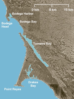
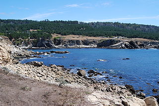
Estero de Limantour State Marine Reserve (SMR) and Drakes Estero State Marine Conservation Area (SMCA) are two adjoining marine protected areas along the Point Reyes National Seashore in Marin County on California’s north central coast. These marine protected areas cover a combined 4.04 square miles (10.5 km2), with 1.49 square miles (3.9 km2) in the SMR and 2.55 square miles (6.6 km2) in the SMCA. Drakes Estero SMCA prohibits the take of all living marine resources from Drakes Estero except the recreational take of clams and formerly the commercial aquaculture of shellfish pursuant to a disputed state water bottom lease and permit, which has been the subject of ongoing legal proceedings since 2012, when the lease was allowed to expire.
Point Reyes State Marine Reserve (SMR) and Point Reyes State Marine Conservation Area (SMCA) are two adjoining marine protected areas that extend offshore of Point Reyes Headlands and within Drakes Bay in Marin County on California’s north central coast. The combined area of these marine protected areas is 21.49 square miles, with 9.38 in the SMR, and 12.11 in the adjacent SMCA. Point Reyes SMR prohibits the take of all living marine resources. Point Reyes SMCA prohibits the take of all living marine resources, except the recreational and commercial take of Dungeness crab by pot and salmon by trolling.

Big Creek State Marine Reserve (SMR) and Big Creek State Marine Conservation Area (SMCA) are two adjoining marine protected areas that lie offshore of Big Sur on California's central coast. The combined area of these marine protected areas is 22.45 square miles (58.1 km2). The SMR protects all marine life within its boundaries. Fishing and take of all living marine resources is prohibited. Within the SMCA fishing and take of all living marine resources is prohibited except the commercial and recreational take of salmon, albacore, and the commercial take of spot prawn.

Carmel Pinnacles State Marine Reserve (SMR) is a marine protected area in Carmel Bay including a unique underwater pinnacle formation with adjacent kelp forest, submarine canyon head, and surfgrass. Carmel Bay is adjacent to the city of Carmel-by-the-Sea and is near Monterey, on California's central coast.

Lovers Point State Marine Reserve (SMR) is one of four small marine protected areas located near the cities of Monterey and Pacific Grove, at the southern end of Monterey Bay on California’s central coast. The four MPAs together encompass 2.96 square miles (7.7 km2). The SMR protects all marine life within its boundaries. Fishing and take of all living marine resources is prohibited.

Morro Bay State Marine Recreational Management Area (SMRMA) and Morro Bay State Marine Reserve (SMR) are two marine protected areas that provide protection for Morro Bay Estuary on California's central coast. The two marine protected areas together encompass 3.31 square miles (8.6 km2). Within the SMRMA, fishing and take of any living marine resources is prohibited except that north of latitude 35° 19.70′ N the recreational take of finfish and aquaculture of oysters, pursuant to a valid state water bottom lease and permit, is permitted. And recreational hunting of waterfowl is allowed unless otherwise restricted by hunting regulations. The SMR protects all marine life within its boundaries. Fishing and take of any living marine resources is prohibited.

Pacific Grove Marine Gardens State Marine Conservation Area is one of four small marine protected areas located near the cities of Monterey and Pacific Grove, at the southern end of Monterey Bay on California’s central coast. The four MPAs together encompass 2.96 square miles (7.7 km2). Within the SMCA fishing and take of all living marine resources is prohibited except the recreational take of finfish and the commercial take of giant and bull kelp by hand under certain conditions. According to the Frommer's guide, the Marine Gardens area is "renowned for ocean views, flowers, and tide-pool seaweed beds."

Piedras Blancas State Marine Reserve (SMR) and Piedras Blancas State Marine Conservation Area (SMCA) are two adjoining marine protected areas that lie offshore of San Luis Obispo County on California’s central coast. The combined area of these marine protected areas is 19.68 square miles (51.0 km2). The SMR protects all marine life within its boundaries. Fishing and take of all living marine resources is prohibited. Within the SMCA fishing and take of all living marine resources is prohibited except the commercial and recreational take of salmon and albacore.

Point Buchon State Marine Reserve (SMR) and Point Buchon State Marine Conservation Area (SMCA) are two adjoining marine protected areas that lie offshore Point Buchon in San Luis Obispo County on California's central coast. The combined area of these piip marine protected areas is 18.21 square miles (47.2 km2). The SMR protects all marine life within its boundaries. Fishing and take of any living marine resources is prohibited. Within the SMCA fishing and take of all living marine resources is prohibited except the commercial and recreational take of salmon and albacore.

Point Sur State Marine Reserve (SMR) and Point Sur State Marine Conservation Area (SMCA) are two adjoining marine protected areas that lie offshore of Point Sur, part of the Big Sur area on California's central coast. The combined area of these marine protected areas is 19.68 square miles (51.0 km2). The SMR protects all marine life within its boundaries. Fishing and taking of all living marine resources is prohibited in the SMR. Within the SMCA, fishing and taking of all living marine resources is prohibited except the commercial and recreational take of salmon and albacore.

White Rock (Cambria) State Marine Conservation Area (SMCA) is a marine protected area located off the coast of the city of Cambria, California on California’s central coast. The marine protected area covers 2.32 square miles (6.0 km2). Within the SMCA the take of all living marine resources is prohibited except the commercial take of giant kelp and bull kelp under certain conditions.
Moss Landing Wildlife Area is a California State wildlife preserve on the shore of Elkhorn Slough.
Famosa Slough State Marine Conservation Area (SMCA) is a marine protected area in San Diego on California’s south coast. It consists of a 25-acre wetland and a 12-acre natural channel connecting to the San Diego River estuary. It is flushed by salt water from the estuary as well as rainwater from the surrounding neighborhood. It is owned and maintained by the City of San Diego as a natural park.

