Yolo Bypass Wildlife Area

Last updated

The entrance to the Yolo Bypass Wildlife Area with the Yolo Causeway to the left. Yolo Bypass Wildlife Area 1.jpeg
The entrance to the Yolo Bypass Wildlife Area with the Yolo Causeway to the left.
Canada geese at the Yolo Bypass Wildlife Area. Sacramento is on the horizon. Smaller canada-geese-and-skyline.jpg
Canada geese at the Yolo Bypass Wildlife Area. Sacramento is on the horizon.

The Yolo Bypass Wildlife Area, located within the Yolo Bypass in Yolo County, California, is managed by the California Department of Fish and Wildlife with the intent of restoring and managing a variety of wildlife habitats in the Yolo Basin, a natural basin in the north part of the Sacramento-San Joaquin River Delta. The creation of the wildlife area was spearheaded by the Yolo Basin Foundation. [1] The California Department of Fish and Wildlife and Yolo Basin Foundation are the core partners in the operation of this resource located at 38°33′02″N121°37′35″W / 38.550515°N 121.626291°W / 38.550515; -121.626291

Contents

History

The wildlife area was open to the public in 1997 after extensive restoration efforts completed by Ducks Unlimited with federal funds appropriated through the United States Army Corps of Engineers. In 1999, this 3,700-acre (15 km2) restoration project was named the Vic Fazio Yolo Wildlife Area in honor of congressman Vic Fazio who lobbied hard for the funds needed to build the project. In 2001, the wildlife area expanded to over 16,000 acres (65 km2) with the acquisition of the Glide and Los Rios properties. These acquisitions included the 10,000-acre (40 km2) Tule Ranch, a working cattle ranch with extensive vernal pool areas.

The entrance to the wildlife area during a major flood. Flood-at-causeway.jpg
The entrance to the wildlife area during a major flood.

Habitats, Flora, & Fauna

Most wetland in the wildlife area are managed as seasonal wetlands. They go through an extensive dry period during the spring and summer months. Typically, these ponds are drained on April 1 to stimulate the germination of Swamp Timothy. They may receive a brief summer irrigation and then be flooded in September to provide wetland habitat for migratory waterfowl and shorebirds.

The threatened giant garter snake is found in aquatic habitats in much of the wildlife area. Giant Garter Snake.jpg
The threatened giant garter snake is found in aquatic habitats in much of the wildlife area.

Permanent wetlands are flooded year round and tend to be deeper and have more emergent vegetation. These ponds provide important brood water for resident aquatic birds such as mallards, common moorhens and pied-billed grebes. They also provide drinking water for wildlife as well as relief from intense summer heat. This habitat is used extensively for roosting by black-crowned night herons, egrets, and white-faced ibis. The giant garter snake also occurs in this habitat.

Upland habitats are used extensively by ground nesting birds such northern harriers, western meadowlarks, mallards and ring-necked pheasant. Vegetation is typically dominated by annual rye grass, curly dock and wild sunflower. Rodent populations in these areas provide prey for large numbers of wintering birds of prey.

Approximately 1,800 acres (7.3 km2) of natural uplands occur in the southwest portion of the wildlife area. There are several vernal pools in this area that are home to such invertebrate species as tadpole shrimp, clam shrimp and the endangered conservancy fairy shrimp. Rare and endangered plants include Heckert's pepperweed and Ferris' alkali milk vetch. Grassland bird species in this area include grasshopper sparrow, Savannah sparrow and burrowing owl.

Extensive fields of wildflowers occur in the spring on the Tule Ranch. Goldfields.JPG
Extensive fields of wildflowers occur in the spring on the Tule Ranch.

Riparian vegetation consists of willows, cottonwoods, black walnut and other tree species. Nesting species here include Swainson's hawks, great-horned owls, wood ducks, tree swallows, and black phoebe. This habitat is very important for neo-tropical migrants such as blue grosbeak, ash-throated flycatchers, and a variety of warbler species. Most riparian vegetation is located along Putah Creek in the central part of the wildlife area.

Agriculture is an integral part of the management of the wildlife area. Milo-harvest.jpg
Agriculture is an integral part of the management of the wildlife area.

Other uses

Flood control

The Yolo Bypass is a 59,000-acre (240 km2) flood control channel that protects Sacramento and other cities from flooding. The wildlife area was created with the understanding that it would remain completely compatible with this primary flood control function. For this reason, there are restrictions on the density of emergent vegetation and riparian trees within the wildlife area. These standards are determined through the use of hydrological models.

Located at the north end of the Yolo Basin where Putah Creek enters the Yolo Bypass, this part of the Delta is known as the Putah Sinks and hosts a diverse assemblage of wildlife species inhabiting seasonal wetlands, permanent wetlands, riparian forest, uplands, vernal pools and agricultural habitats.

White-fronted geese rising into a November sunrise. White fronted geese at sunrise.jpg
White-fronted geese rising into a November sunrise.

Agriculture

The extensive use of agriculture achieves its wildlife habitat goals, while providing important operating income. In the northern portions of the wildlife area, rice is grown, which is then flooded after harvest, attracting thousands of waterfowl and shorebirds in view of the automobiles on Interstate 80. Wildlife managers have instituted a crop rotation within the rice fields that allows for a fallow stage every three years. During this fallow stage, the field is managed for migratory shorebirds by flooding during the mid-summer months.

Public use

Kids learn about wetlands in the "Discover the Flyway" program. Discover the Flyway.JPG
Kids learn about wetlands in the "Discover the Flyway" program.
California Department of Fish and Wildlife mobile aquarium at California Duck Days CDFW Mobile Aquarium 2.jpeg
California Department of Fish and Wildlife mobile aquarium at California Duck Days

The wildlife area is open every day (except Christmas) for wildlife viewing and fishing. Tours are conducted by volunteers from the Yolo Basin Foundation. Other public use opportunities are provided by the Yolo Basin Foundation and Fish and Wildlife including bat tours, open houses and a speaker series.

Hunting for waterfowl, pheasant and mourning dove is conducted in specific area by the California Department of Fish and Wildlife during the fall and winter months.

The "Discover the Flyway" environmental education program annually brings approximately 4,000 students per year to learn about wetlands and visit the wildlife area. California Duck Days is an annual wildlife festival held each February, which includes educational exhibits and field trips to observe wildlife. [2] Other activities include trout fishing for children, a mobile aquarium and displays of live captive raptors. [3]

Tule Ranch

This 10,000-acre (40 km2) ranch was purchased in 2001 as part of a large expansion of the wildlife area. It had been owned by the Glide family for over 130 years. Since the acquisition, approximately 5,000 acres (20 km2) of new wetlands have been restored on this property. The western portion of the Tule Ranch contains vernal pools within a mostly natural grassland. Spectacular wildflower displays occur in the spring. Some notable breeding grassland species include grasshopper sparrow, Savannah sparrow and western meadowlark. A prominent landmark in the area is the Umbrella Barn, a large wooden barn that is over 100 years old.

The cathedral like interior of the 100-year-old Umbrella Barn. Umbrella barn interior.jpg
The cathedral like interior of the 100-year-old Umbrella Barn.
Snow geese descend upon irrigated pasture on the Tule Ranch Cow geese.jpg
Snow geese descend upon irrigated pasture on the Tule Ranch

The Tule Ranch is host to a large grazing program. Some fields are managed for maximum nutritional value in the form of legumes such as burr clover. These fields also provide important forage for migratory snow geese and white-fronted geese. Cattle are the primary management tool in the vernal pool habitat area. Their removal of thatch from the thick stands of annual rye grass help facilitate the germination of native forbs in this area, resulting in spectacular blooms of wildflowers each spring. At the very bottom of the Tule Ranch is the Fireman's Club, a square mile of property that contains a historic slough that once drained into the Yolo Basin. This section of land was hunted by the Dixon Fire District employees for many years in exchange for their emergency services to the ranch.

Related Research Articles

<span class="mw-page-title-main">Yolo Bypass</span> Flood bypass in the Sacramento Valley

The Yolo Bypass is one of the two flood bypasses in California's Sacramento Valley located in Yolo and Solano Counties. Through a system of weirs, the bypass diverts floodwaters from the Sacramento River away from the state's capital city of Sacramento and other nearby riverside communities.

<span class="mw-page-title-main">Vic Fazio Yolo Wildlife Area</span>

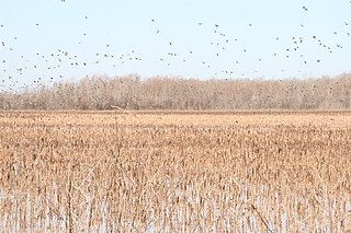
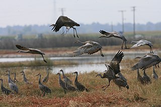
The Vic Fazio Yolo Wildlife Area is a 3,700 acres (15 km2) wetland restoration project constructed by the United States Army Corps of Engineers and Ducks Unlimited within the Yolo Bypass Wildlife Area located in the Yolo Bypass in Yolo County, California, between the cities of Sacramento and Davis. The Yolo Causeway, part of Interstate 80, runs through it. The restoration was named for Congressman Vic Fazio, who lobbied for the project and was instrumental in appropriating funds for the initial construction. The Yolo Bypass Wildlife Area was dedicated in 1997 by President Bill Clinton. The facility is managed by the California Department of Fish and Wildlife while the educational programs and public tours are administered by the Yolo Basin Foundation, which works to educate and inform the public.

<span class="mw-page-title-main">Goleta Slough</span> Wetland in Santa Barbara County, California

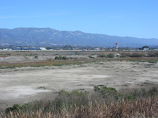
The Goleta Slough is an area of estuary, tidal creeks, tidal marsh, and wetlands near Goleta, California, United States. It primarily consists of the filled and unfilled remnants of the historic inner Goleta Bay about 8 miles (13 km) west of Santa Barbara. The slough empties into the Pacific Ocean through an intermittently closed mouth at Goleta Beach County Park just east of the UCSB campus and Isla Vista. The slough drains the Goleta Valley and watershed, and receives the water of all of the major creeks in the Goleta area including the southern face of the Santa Ynez Mountains.

<span class="mw-page-title-main">Klamath Basin National Wildlife Refuge Complex</span>

The Klamath Basin National Wildlife Refuge Complex is a wildlife preserve operated by the United States Fish and Wildlife Service in the Klamath Basin of southern Oregon and northern California near Klamath Falls, Oregon. It consists of Bear Valley, Klamath Marsh and Upper Klamath National Wildlife Refuge (NWR) in southern Oregon and Lower Klamath, Tule Lake, and Clear Lake NWR in northern California.

<span class="mw-page-title-main">Suisun Marsh</span> Largest brackish water marsh on west coast of US

Located in northern California, the Suisun Marsh has been referred to as the largest brackish water marsh on west coast of the United States of America. The marsh land is part of a tidal estuary, and subject to tidal ebb and flood. The marsh is home to many species of birds and other wildlife, and is formed by the confluence of the Sacramento and San Joaquin rivers between Martinez and Suisun City, California and several other smaller, local watersheds. Adjacent to Suisun Bay, the marsh is immediately west of the legally defined Sacramento-San Joaquin Delta as well as part of the San Francisco Bay estuary.

<span class="mw-page-title-main">Grand Cote National Wildlife Refuge</span>

The Grand Cote National Wildlife Refuge was established in 1989 as part of the North American Waterfowl Management Plan. It is a 6,000-acre (24 km2) reserve located in Avoyelles Parish, near Marksville, Louisiana, in the United States.

<span class="mw-page-title-main">Nomans Land Island National Wildlife Refuge</span>

The Nomans Land Island Wildlife Refuge is a United States National Wildlife Refuge located on Nomans Land, a 640-acre (2.6 km2) island off the coast of Martha's Vineyard in Massachusetts. It is part of the town of Chilmark, in Dukes County. The Island is 1.6 miles (2.6 km) long east to west, and about 1 mile (1.6 km) north to south. Nomans Land Island was used for aerial gunnery by the U.S. Navy from 1942 to 1996. The United States Fish and Wildlife Service has managed an "overlay" refuge on the Eastern third of the Island under a Joint Management Agreement between the Department of the Interior and Department of the Navy since 1975. Following an extensive surface clearance of ordnance in 1997 and 1998, the Island was transferred to the United States Fish and Wildlife Service to become Nomans Land Island National Wildlife Refuge. It was established ". .. for use as an inviolate sanctuary, or for any other management purpose, for migratory birds" under the Migratory Bird Conservation Act.

Catahoula National Wildlife Refuge, located in east central Louisiana, United States, 12 miles (19 km) east of Jena, was established in 1958 as a wintering area for migratory waterfowl. The refuge contains 25,162 acres (101.83 km2) divided into two units. The 6,671-acre (27 km2) Headquarters Unit borders nine miles (14 km) of the northeast shore of Catahoula Lake, a 26,000-acre (110 km2) natural wetland renowned for its large concentrations of migratory waterfowl. The 18,491-acre (74.83 km2) Bushley Bayou Unit, located 8 miles (13 km) west of Jonesville, was established May 16, 2001. This acquisition was made possible through a partnership agreement between The Conservation Fund, American Electric Power, and the Fish and Wildlife Service. The habitat found at the refuge is primarily lowland hardwood forest subject to seasonal backwater flooding from the Ouachita, and Red Rivers.

The San Luis National Wildlife Refuge Complex is located in the northern San Joaquin Valley, within Merced County and Stanislaus County of California. The complex, with four federal National Wildlife Refuges, is managed by the U.S Fish & Wildlife Service.

<span class="mw-page-title-main">Cache Creek Wilderness</span> Land preserve in Lake County, California

The Cache Creek Wilderness is a 27,245-acre (11,026 ha) wilderness area located in Lake County, California. The wilderness was added to the National Wilderness Preservation System when the United States Congress passed the Northern California Coastal Wild Heritage Wilderness Act in 2006. In July 2015, the area became part of Berryessa Snow Mountain National Monument. The Department of the Interior's Bureau of Land Management (BLM) is the agency in charge.

<span class="mw-page-title-main">Cosumnes River Preserve</span> Jointly managed protected area in the Central Valley of California

The Cosumnes River Preserve is a nature preserve of over 51,000 acres (210 km2) located 20 miles (30 km) south of Sacramento, in the US state of California. The preserve protects a Central Valley remnant that once contained one of the largest expanses of oak tree savanna, riparian oak forest and wetland habitat in North America. Agricultural development has changed the landscape from groves of oaks and tule marshes to productive farmlands.

<span class="mw-page-title-main">Hamden Slough National Wildlife Refuge</span> National wildlife refuge in Minnesota, United States

Hamden Slough National Wildlife Refuge is a National Wildlife Refuge of the United States in Minnesota. Eastern hardwood forests stretching from the Atlantic seaboard give way to the western prairie at the area, in Audubon Township, near Audubon, Minnesota. Prior to settlement, its diverse vegetation was attractive to wildlife: waterfowl, upland birds, bison, wolves, and other prairie wildlife. When fully restored, the refuge will provide the largest contiguous block of wetland prairie habitat in the region, encompassing nearly 6,000 acres (24 km2).

<span class="mw-page-title-main">Hagerman National Wildlife Refuge</span> Nature reserve in northwestern Grayson County, Texas, United States

Hagerman National Wildlife Refuge (HNWR), a haven for migratory birds and other wildlife, lies in northwestern Grayson County, Texas, on the Big Mineral Arm of Lake Texoma, on the Red River between Oklahoma and Texas. This National Wildlife Refuge is made up of water, marsh, and upland habitat. Visitors can hike, observe wildlife, hunt, and fish throughout the year.

<span class="mw-page-title-main">Pixley National Wildlife Refuge</span> Wildlife Refuge in the San Joaquin Valley

Pixley National Wildlife Refuge is located 35 miles (56 km) south of Tulare, California and 45 miles (72 km) north of Bakersfield in the San Joaquin Valley. The 6,939-acre (2,808 ha) nature refuge represents one of the few remaining examples of the grasslands, vernal pools, and playas that once bordered historic Tulare Lake, the largest lake west of the Great Lakes until the late 19th century.

<span class="mw-page-title-main">Modoc National Wildlife Refuge</span> National Wildlife Refuge in the United States

Modoc National Wildlife Refuge is a National Wildlife Refuge of the United States located in northeastern California. It is next to the South Fork of the Pit River in Modoc County, southeast of Alturas.

<span class="mw-page-title-main">Merced National Wildlife Refuge</span> Nature reserve in California

The Merced National Wildlife Refuge encompasses 10,262 acres (41.53 km2) of wetlands, native grasslands, vernal pools, and riparian areas in California. It was established in 1951 under the Lea Act to attract wintering waterfowl from adjacent farmland where their foraging was causing crop damage. In the last few decades, changes in agricultural practices and refuge management have reduced these wildlife/crop issues.

<span class="mw-page-title-main">Kern River Preserve</span>

The Audubon Kern River Preserve is a riparian nature reserve owned by the National Audubon Society in the US state of California, near Weldon in Kern County.

<span class="mw-page-title-main">Ana River</span> River in Oregon, United States of America

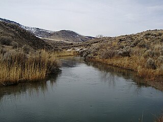
The Ana River is a short spring-fed river in south-central Oregon. It is on the northwestern edge of the Great Basin drainage. It flows 7 miles (11 km) from springs at the foot of Winter Ridge through high desert, range, and wetlands before emptying into Summer Lake. For most of its course, the Ana River flows through the Summer Lake Wildlife Area, which is maintained by the Oregon Department of Fish and Wildlife. The river provides habitat for many mammal and bird species, as well as several fish species, including the rare Summer Lake Tui chub. The largest hybrid striped bass ever caught in Oregon was taken from Ana Reservoir in 2009.

<span class="mw-page-title-main">Summer Lake Wildlife Area</span> Wildlife refuge in Oregon

The Summer Lake Wildlife Area is a 29.6-square-mile (77 km2) wildlife refuge located on the northwestern edge of the Great Basin drainage in south-central Oregon. It is administered by the Oregon Department of Fish and Wildlife. The refuge is an important stop for waterfowl traveling along the Pacific Flyway during their spring and fall migrations. The Summer Lake Wildlife Area also provides habitat for shorebirds and other bird species as well as wide variety of mammals and several fish species. The Ana River supplies the water for the refuge wetlands.

<span class="mw-page-title-main">Fremont Weir Wildlife Area</span> Protected area in California

Fremont Weir Wildlife Area is 1,461 acres (591 ha) at the north end of the Yolo Bypass floodway along the Sacramento River in Sutter County and Yolo County. It is 6 miles north-east of the city of Woodland and 15 miles north of Yolo Bypass Wildlife Area and the nearby Sacramento Bypass Wildlife Area. Whenever water in the river exceeds the height of the weir the excess flow runs over the weir and down the Yolo Bypass floodway, thereby reducing the risks of flooding in the city of Sacramento and nearby urban areas along the river.

References

  1. "Yolo Basin Foundation -". Yolo Basin Foundation. Retrieved April 10, 2018.
  2. "Escapes: Make plans for California Duck Days in Davis". Sacramento Bee . February 10, 2013. Retrieved March 1, 2014.
  3. "California Duck Days return to Davis". Davis Enterprise . January 31, 2014. Retrieved March 1, 2014.