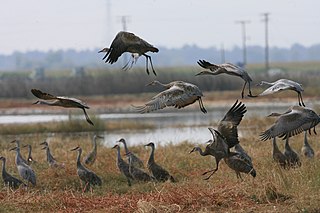
The Bald Knob National Wildlife Refuge is a 15,022 acres (60.79 km2) (2014) wildlife refuge located in White County, Arkansas about two miles south of the town of Bald Knob. The refuge is managed by the United States Fish and Wildlife Service. The refuge features large numbers of migratory waterfowl and bald eagles during the winter months.

The Wheeler National Wildlife Refuge is a 35,000 acre (142 km2) National Wildlife Refuge located along the Tennessee River near Decatur, Alabama. Named after Major General Joseph Wheeler, it was established to provide a habitat for wintering and migrating birds in the eastern United States.

Browns Park National Wildlife Refuge is a 13,450-acre (5,440 ha) U.S. National Wildlife Refuge located in northwestern Colorado. It is located in Moffat County in the extreme northwestern corner of the state, in an isolated mountain valley of Browns Park on both sides of the Green River, approximately 25 miles (40 km) below Flaming Gorge Dam. Established in 1965, the refuge is managed by the United States Fish and Wildlife Service office in Maybell, Colorado. The refuge is approximately 53 miles (85 km) northwest of Maybell on State Highway 318. The refuge consists of bottomland and adjacent benchland. The western border of the refuge is the Colorado-Utah state line. The refuge is surrounded by adjacent lines of the Bureau of Land Management. The refuge contains the site of the former Fort Davy Crockett that was constructed in 1837 to protect trappers against attacks by Blackfoot Native Americans.

William L. Finley National Wildlife Refuge is a natural area in the Willamette Valley in Oregon, United States. It was created to provide wintering habitat for dusky Canada geese. Unlike other Canada geese, dusky Canada geese have limited summer and winter ranges. They nest on Alaska's Copper River Delta and winter almost exclusively in the Willamette Valley. Habitat loss, predation, and hunting have caused a decrease in population.

Ankeny National Wildlife Refuge is located in the fertile Willamette Valley of northwestern Oregon, 12 miles (19 km) south of Salem. The valley was once a rich mix of wildlife habitats. Valley wetlands were once extensive, with meandering stream channels and vast seasonal marshes. Today, the valley is a mix of farmland and growing cities, with few areas remaining for wildlife.

Baskett Slough National Wildlife Refuge is in northwestern Oregon, 10 miles (16 km) west of Salem in Polk County. The Refuge consists of 1,173 acres (4.75 km²) of cropland, which provide forage for wintering geese, 300 acres (1.2 km²) of forests, 550 acres (2.2 km²) of grasslands, and 500 acres (2.0 km²) of shallow water seasonal wetlands and 35 acres (0.14 km²) of permanent open water. In 1965, Baskett Slough National Wildlife Refuge was created to help ensure some of the original habitat remained for species preservation. The refuge is managed by the U.S. Fish and Wildlife Service, an agency of the U.S. Department of the Interior.
Grays Lake is a wetland in Idaho, United States. It lies in Bonneville County and Caribou County. Grays Lake National Wildlife Refuge was established in the area in 1965. Ranching is the predominant use of surrounding lands.

Glacial Ridge National Wildlife Refuge was created on October 12, 2004, the 545th National Wildlife Refuge in the United States. Its creation was the result of cooperation between at least 30 agencies or governmental entities. The creation of the refuge was spearheaded by The Nature Conservancy, and the initial endowment of 2,300 acres (9.3 km2) of land was donated by the Conservancy. In light of its planned final size of 37,756 acres (153 km2), it is described by the US Fish and Wildlife Service as "the largest tallgrass prairie and wetland restoration project in U.S. history."

According to the California Protected Areas Database (CPAD), in the state of California, United States, there are over 14,000 inventoried protected areas administered by public agencies and non-profits. In addition, there are private conservation areas and other easements. They include almost one-third of California's scenic coastline, including coastal wetlands, estuaries, beaches, and dune systems. The California State Parks system alone has 270 units and covers 1.3 million acres (5,300 km2), with over 280 miles (450 km) of coastline, 625 miles (1,006 km) of lake and river frontage, nearly 18,000 campsites, and 3,000 miles (5,000 km) of hiking, biking, and equestrian trails.

The Yolo Bypass Wildlife Area is located within the Yolo Bypass in Yolo County, California. The wildlife area is managed by the California Department of Fish and Wildlife with the intent of restoring and managing a variety of wildlife habitats in the Yolo Basin, a natural basin in the north part of the Sacramento-San Joaquin River Delta. The creation of the wildlife area was spearheaded by the Yolo Basin Foundation. The California Department of Fish and Wildlife and Yolo Basin Foundation are the core partners in the operation of this unique community resource. Located at 38.550515°N 121.626291°W

Catahoula National Wildlife Refuge, located in east central Louisiana, United States, 12 miles (19 km) east of Jena, was established in 1958 as a wintering area for migratory waterfowl. The refuge contains 25,162 acres (101.83 km2) divided into two units. The 6,671-acre (27 km2) Headquarters Unit borders nine miles (14 km) of the northeast shore of Catahoula Lake, a 26,000-acre (110 km2) natural wetland renowned for its large concentrations of migratory waterfowl. The 18,491-acre (74.83 km2) Bushley Bayou Unit, located 8 miles (13 km) west of Jonesville, was established May 16, 2001. This acquisition was made possible through a partnership agreement between The Conservation Fund, American Electric Power, and the Fish and Wildlife Service. The habitat found at the refuge is primarily lowland hardwood forest subject to seasonal backwater flooding from the Ouachita, and Red Rivers.
The San Luis National Wildlife Refuge Complex is located in the northern San Joaquin Valley, within Merced County and Stanislaus County of California. The complex, with four federal National Wildlife Refuges, is managed by the U.S Fish & Wildlife Service.

The Sonny Bono Salton Sea National Wildlife Refuge is located in the Imperial Valley of California, 40 miles (64 km) north of the Mexican border. Situated at the southern end of the Salton Sea, the refuge protects one of the most important nesting sites and stopovers along the Pacific Flyway. Despite its location in the Colorado Desert, a subdivision of the larger Sonoran Desert, the refuge contains marine, freshwater, wetland, and agricultural habitats which provide sanctuary for hundreds of birds and wetland species, including several that have been listed as endangered or sensitive by the U.S. Fish and Wildlife Service.

Hagerman National Wildlife Refuge (HNWR), a haven for migratory birds and other wildlife, lies in northwestern Grayson County, Texas, on the Big Mineral Arm of Lake Texoma, on the Red River between Oklahoma and Texas. This National Wildlife Refuge is made up of water, marsh, and upland habitat. Visitors can hike, observe wildlife, hunt, and fish throughout the year.

The Delevan National Wildlife Refuge is one of six refuges in the Sacramento National Wildlife Refuge Complex in the Sacramento Valley of central northern California.

Colusa National Wildlife Refuge is one of six refuges in the Sacramento National Wildlife Refuge Complex located in the Sacramento Valley of north-central California. The refuge is located in Colusa County. It is around 70 miles (110 km) north of metropolitan Sacramento.

The Merced National Wildlife Refuge encompasses 10,262 acres (41.53 km2) of wetlands, native grasslands, vernal pools, and riparian areas in California. It was established in 1951 under the Lea Act to attract wintering waterfowl from adjacent farmland where their foraging was causing crop damage. In the last few decades, changes in agricultural practices and refuge management have reduced these wildlife/crop issues.
Located within 11 counties in the Sacramento Valley and the Sacramento-San Joaquin Delta of California, North Central Valley Wildlife Management Area consists of conservation easements acquired on privately owned wetlands. The landscape is very flat, bordered by the Sierra and Coast ranges and is surrounded by intensive agriculture.
Willow Creek-Lurline Wildlife Management Area is located in the Sacramento Valley of California. The landscape is very flat, bordered by the Sierra and Coast ranges and surrounded by intensive agriculture. The objective of this wildlife management area is to protect fall/winter habitat for waterfowl through the acquisition of conservation easements on privately owned wetlands. It is not open to the public.

The Refuge Water Supply Program (RWSP) is administered by the United States Department of the Interior jointly by the Bureau of Reclamation and Fish and Wildlife Service and tasked with acquiring a portion and delivering a total of 555,515 acre feet (AF) of water annually to 19 specific protected wetland areas in the Central Valley of California as mandated with the passing of the Central Valley Project Improvement Act signed on October 30, 1992, by President George H. W. Bush.


