
The Low Desert is a common name for any desert in California that is under 2,000 feet in altitude. These areas include, but are not exclusive to, the Colorado Desert and Yuha Desert, in the Southern California portion of the Sonoran Desert. These areas are distinguished in biogeography from the adjacent northern High Desert or Mojave Desert by latitude, elevation, animal life, climate, and native plant communities.

The Sangre de Cristo Mountains are the southernmost subrange of the Rocky Mountains. They are located in southern Colorado and northern New Mexico in the United States. The mountains run from Poncha Pass in South-Central Colorado, trending southeast and south, ending at Glorieta Pass, southeast of Santa Fe, New Mexico. The mountains contain a number of fourteen thousand foot peaks in the Colorado portion, as well as all the peaks in New Mexico which are over twelve thousand feet.
The Lost Creek Wilderness is a 119,790-acre (485 km2) wilderness area located in central Colorado in Jefferson and Park counties south of the town of Bailey. The area is situated entirely within the boundaries of the Pike National Forest.

White River National Forest is a National Forest in northwest Colorado. It is named after the White River that passes through its northern section. It is the most visited National Forest in the United States, primarily from users of the twelve ski areas within its boundaries.

The Maroon Bells are two peaks in the Elk Mountains, Maroon Peak and North Maroon Peak, separated by about half a kilometer. The mountains are on the border between Pitkin County and Gunnison County, Colorado, United States, about 12 miles (19 km) southwest of Aspen. Both peaks are fourteeners. Maroon Peak, at 14,163 feet (4317 m), is the 27th highest peak in Colorado. North Maroon Peak, at 14,019 feet (4273 m), is the 50th highest. The view of the Maroon Bells to the southwest from the Maroon Creek valley is very heavily photographed. The peaks are located in the Maroon Bells–Snowmass Wilderness of White River National Forest. Maroon Bells-Snowmass Wilderness was one of five areas in Colorado designated as wilderness in the original Wilderness Act of 1964. The Wilderness area surrounds the extremely popular Maroon Bells Scenic Area, which is a major access point for Wilderness travel.

The Sierra Ancha is a mountain range in Gila County, in central Arizona. It lies between Roosevelt Lake to the south, the Tonto Basin to the west, Cherry Creek to the east, and Pleasant Valley to the north. The range is one of several, including the Bradshaw Mountains, Mingus Mountain of the Black Hills, and the Mazatzal Mountains, which form a transitional zone between the lowland deserts of southern Arizona and the Colorado Plateau of northeastern Arizona. The highest point in the range is Aztec Peak, at an elevation of 2345 m (7694 ft).

The Turtle Mountains, are located in northeastern San Bernardino County, in the southeastern part of California. The colorful Turtle Mountains vary from deep reds, browns, tans and grays, to black. The area has numerous springs and seeps. The Turtle Mountains are also a National Natural Landmark, with two mountain sections of entirely different composition.

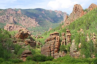
Greenhorn Mountain is the highest summit of the Wet Mountains range in the Rocky Mountains of North America. The prominent 12,352-foot (3,765 m) peak is located in the Greenhorn Mountain Wilderness of San Isabel National Forest, 5.2 miles (8.4 km) southwest by west of the Town of Rye, Colorado, United States, on the boundary between Huerfano and Pueblo counties. The summit of Greenhorn Mountain is the highest point in Pueblo County, Colorado. The peak's summit rises above timberline, which is about 11,500 feet (3,500 m) in south-central Colorado.

The Muggins Mountains is a mountain range in southwest Arizona east of Yuma, Arizona, northeast of the Gila Mountains, and east of the Laguna Mountains. The Castle Dome Mountains lie to the northeast across the broad Castle Dome Plain. The Muggins Mountains Wilderness occupies the southwest portion of the range.
The Dome Rock Mountains are a mountain range in southern La Paz County, Arizona. The range borders the Colorado River on the west and the Colorado River Indian Reservation on the northwest located in the Lower Colorado River Valley. Quartzsite, Arizona lies on the eastern foothills of the range.

The Mopah Range is a desert mountain range, in the Lower Colorado River Valley region, in southeastern San Bernardino County, California.

The Whipple Mountains Wilderness is a 76,122-acre (30,805 ha) wilderness administered by the Bureau of Land Management (BLM). Most of the Whipple Mountains are within the wilderness area. It is located in the northeastern Colorado Desert near the Colorado River. Lake Havasu and Lake Havasu City are 25 miles (40 km) to the North. Earp, California and Parker, Arizona are 20 miles (32 km) to the South. The Parker Dam is 8 miles (13 km) due east.

The Tonopah Desert is a small desert plains region of the Sonoran Desert, located west of Phoenix, Arizona. It is adjacent north of Interstate 10 and lies at the southwest intersection of the Hassayampa River with the Gila River. The Tonopah Desert is also just north of the Gila Bend Mountains massif which create the Gila Bend of the river.

The Palo Verde Valley is located in the Lower Colorado River Valley, next to the eastern border of Southern California with Arizona, United States. It is located on the Colorado Desert within the Sonoran Desert south of the Parker Valley. Most of the valley is in Riverside County, with the southern remainder in Imperial County. La Paz County borders to the east on the Colorado River.
BUzzards Peak Wilderness is a protected wilderness area to the southeast of the Milpitas Wash Wilderness separated by California State Route 78 in Imperial County, California. Established in 2019 by the U.S. Congress, the area is managed by the Bureau of Land Management. Indian Pass Wilderness, Imperial National Wildlife Refuge and the Colorado River are to the south and southeast. Wildlife includes the desert tortoise, Yuma kingsnake, Colorado River toad, Great Plains toad, tree lizard, burros, mule deer and mountain lion. Vegetation found in the area: cholla and beavertail cactus, ocotillo, palo verde, acacia, ironwood, and the rare California Ditaxis.
Milpitas Wash Wilderness is a protected wilderness area to the south of the Palo Verde Mountains and to the west of Cibola National Wildlife Refuge and the Colorado River in Imperial County, California. Established in 2019 by the U.S. Congress, the area is managed by the Bureau of Land Management. Wildlife includes the desert tortoise, mountain lion, long-eared owl, leaf nosed bat, Merriam's and desert kangaroo rat, long-tailed and little pocket mice, Bullock's and hooded orioles, towhees, white-crowned sparrow, Brewer's sparrow, warbler, black-headed grosbeak, diamondback rattlesnake, and the endangered Gila woodpecker. Home to the largest Sonoran desert woodland in North America, trees in Milpitas Wash include mesquite, acacia, palo verde, and ironwood.
