
America's first transcontinental railroad was a 1,911-mile (3,075 km) continuous railroad line built between 1863 and 1869 that connected the existing eastern U.S. rail network at Council Bluffs, Iowa, with the Pacific coast at the Oakland Long Wharf on San Francisco Bay. The rail line was built by three private companies over public lands provided by extensive U.S. land grants. Building was financed by both state and U.S. government subsidy bonds as well as by company-issued mortgage bonds. The Western Pacific Railroad Company built 132 miles (212 km) of track from the road's western terminus at Alameda/Oakland to Sacramento, California. The Central Pacific Railroad Company of California (CPRR) constructed 690 miles (1,110 km) east from Sacramento to Promontory Summit, Utah Territory. The Union Pacific Railroad (UPRR) built 1,085 miles (1,746 km) from the road's eastern terminus at the Missouri River settlements of Council Bluffs and Omaha, Nebraska, westward to Promontory Summit.

The Denver and Rio Grande Western Railroad, often shortened to Rio Grande, D&RG or D&RGW, formerly the Denver & Rio Grande Railroad, was an American Class I railroad company. The railroad started as a 3 ft narrow-gauge line running south from Denver, Colorado, in 1870. It served mainly as a transcontinental bridge line between Denver and Salt Lake City, Utah. The Rio Grande was also a major origin of coal and mineral traffic.

Coalville is a city in and the county seat of Summit County, Utah, United States. It is part of the Salt Lake City, Utah Metropolitan Statistical Area. The population was 1,486 as of the 2020 census. Interstate 80 passes through the town, as well as the Weber River, which flows into Echo Reservoir, just north of Coalville.

Parleys Canyon is a canyon located in the U.S. state of Utah. The canyon provides the route of Interstate 80 (I-80) up the western slope of the Wasatch Mountains and is a relatively wide, straight canyon other than near its mouth. The mountain pass at the top of the canyon is known as Parleys Summit. With an elevation of 7,120 feet (2,170 m), the pass is the highest point along I-80 in the state of Utah. Both features are named for Parley P. Pratt, an early settler of the Salt Lake Valley and leader of the Church of Jesus Christ of Latter-day Saints who surveyed the area to find a better transportation route through the Wasatch Mountains than the previous route which traversed Emigration Canyon.

The Georgetown Loop Railroad is a 3 ft narrow gauge United States heritage railroad located in the Rocky Mountains in Clear Creek County, adjacent to Interstate 70 in Colorado.

Boreas Pass is a high mountain pass in central Colorado, in the Rocky Mountains of the western United States. The pass is located on the continental divide, at the crest of the Front Range along the border between Park (south) and Summit counties.

The Sumpter Valley Railway, or Sumpter Valley Railroad, is a 3 ft narrow gauge heritage railroad located in Baker County, in the U.S. state of Oregon. Built on a right-of-way used by the original railway of the same name, it carries excursion trains on a roughly 5-mile (8.0 km) route between McEwen and Sumpter. The railroad has two steam locomotives and several other pieces of rolling stock. Passenger excursion trains operate on weekends and holidays from Memorial Day through the end of September.
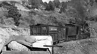
The Uintah Railway was a small 3 ft narrow gauge railroad company in Utah and Colorado in the United States. It was constructed to carry Gilsonite which provided most of its operating revenues; but it operated as a common carrier from 1904 to 1939, also carrying passengers, mail, express, and other cargoes including sheep and wool. When a public library was built in Dragon in 1910, the Uintah Railway agreed to deliver library books free of charge to and from any borrower along its route. Many area ranchers and miners took advantage of the opportunity.

Thistle is a ghost town in Spanish Fork Canyon in southeastern Utah County, Utah, United States. During the era of steam locomotives, the town's primary industry was servicing trains for the Denver and Rio Grande Western Railroad. The fortunes of the town were closely linked with those of the railroad until the changeover to diesel locomotives, when the town started to decline.

The Colorado and Southern Railway was an American Class I railroad in the western United States that operated independently from 1898 to 1908, then as part of the Chicago, Burlington and Quincy Railroad until it was absorbed into the Burlington Northern Railroad in 1981.

A predecessor to the Class I Delaware and Hudson Railway, the 1820s-built Delaware and Hudson Canal Company Gravity Railroad('D&H Gravity Railroad') was a historic gravity railroad incorporated and chartered in 1826 with land grant rights in the US state of Pennsylvania as a humble subsidiary of the Delaware and Hudson Canal and it proved to contain the first trackage of the later organized Delaware and Hudson Railroad. It began as the second long U.S. gravity railroad built initially to haul coal to canal boats, was the second railway chartered in the United States after the Mohawk and Hudson Rail Road before even, the Baltimore and Ohio. As a long gravity railway, only the Summit Hill and Mauch Chunk Railroad pre-dated its beginning of operations.

Swatara State Park is a 3,515-acre (1,422 ha) Pennsylvania state park in Bethel, Swatara and Union Townships, Lebanon and Pine Grove Township, Schuylkill Counties in Pennsylvania in the United States. 8 miles (13 km) of Swatara Creek lie within the park's boundaries, which are roughly formed by Pennsylvania Route 443 to the north and Interstate 81 to the south. The park is in a valley in the ridge and valley region of Pennsylvania between Second Mountain (north) and Blue Mountain (south).
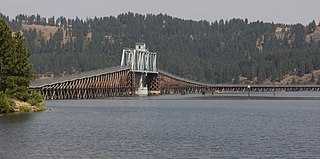
The Trail of the Coeur d'Alenes is a rail trail in the northwest United States, in northern Idaho. It follows the former Union Pacific Railroad right-of-way from Mullan, a mountain mining town near the Montana border, westward to Plummer, a town on the prairie near the Washington border. Generally following the Coeur d'Alene River, the rail line was abandoned in 1991, and the trail officially opened in March 2004.

Standard gauge was favored for railway construction in the United States, although a fairly large narrow-gauge system developed in the Rocky Mountains of Colorado and Utah. Isolated narrow-gauge lines were built in many areas to minimize construction costs for industrial transport or resort access, and some of these lines offered common carrier service. Outside Colorado, these isolated lines evolved into regional narrow-gauge systems in Maine, New York, Pennsylvania, Ohio, Iowa, Hawaii, and Alaska.
The Mauch Chunk Switchback Railway, also known as the Mauch Chunk and Summit Railroad and occasionally shortened to Mauch Chunk Railway, was a coal-hauling railroad in the mountains of Pennsylvania that was built in 1827 and operated until 1932. It was the second gravity railway constructed in the United States, which was used by the Lehigh Coal & Navigation Company to transport coal from Summit Hill downhill to the Lehigh canal.

The Utah Division of the former Denver & Rio Grande Western Railroad (D&RGW) is a rail line that connects Grand Junction, Colorado and Salt Lake City, Utah in the Western United States. It is now incorporated into the Union Pacific Railroad (UP) system as part of the Central Corridor. The modern Union Pacific has split the line into two subdivisions for operational purposes, the Green River Subdivision between Grand Junction and Helper, Utah and the Provo Subdivision from Helper to Salt Lake City. Daily passenger service is provided by Amtrak's California Zephyr; the BNSF Railway and Utah Railway have trackage rights over the line.
The Lynndyl Subdivision is a rail line owned and operated by the Union Pacific Railroad in the U.S. state of Utah, running from Salt Lake City southwest to Milford, where the Caliente Subdivision continues towards Los Angeles. It was formerly part of the Los Angeles and Salt Lake Railroad and a section currently forms a segment of Union Pacific's Central Corridor. The subdivision is named for Lynndyl, a small community along the rail line. The highest elevation attained on the line is 6,061 feet (1,847 m) at Tintic. As of 2003 the line sees 16 trains daily between Lynndyl and Smelter.
Grass Creek is a ghost town in Summit County, Utah, United States. Lying some 8 miles (13 km) northeast of Coalville, it was once an important coal mining town. Grass Creek was inhabited circa 1860–1940.
The Bill Chipman Palouse Trail is a paved rail trail in the northwestern United States, from Pullman, Washington, eastward to Moscow, Idaho. Completed 25 years ago in 1998, it follows the former Union Pacific Railroad right-of-way and connects the rural university towns on the Palouse across the state border.


