Grand Canyon National Park

Last updated

Grand Canyon National Park
Dawn on the S rim of the Grand Canyon (8645178272).jpg
Grand Canyon from the South Rim at dawn
USA Arizona relief location map.svg
Red pog.svg
Location in Arizona
Usa edcp relief location map.png
Red pog.svg
Location in the United States
Location Coconino and Mohave counties, Arizona, United States
Nearest city Fredonia, Arizona (North Rim)
Tusayan, Arizona (South Rim)
Coordinates 36°03′19″N112°07′19″W / 36.0552608°N 112.1218355°W / 36.0552608; -112.1218355 [2]
Area1,217,262 acres (4,926.08 km2) [3]
EstablishedJanuary 11, 1908 (1908-01-11) as a national monument
February 26, 1919 (1919-02-26) as a national park
Visitors4,733,705(in 2023) [4]
Governing body National Park Service
Website www.nps.gov/grca/index.htm OOjs UI icon edit-ltr-progressive.svg
Criteria Natural: vii, viii, ix, x
Reference 75
Inscription1979 (3rd Session)

Grand Canyon National Park, located in northwestern Arizona, is the 15th site in the United States to have been named as a national park. The park's central feature is the Grand Canyon, a gorge of the Colorado River, which is often considered one of the Wonders of the World. The park, which covers 1,217,262 acres (1,901.972 sq mi; 4,926.08 km2) of unincorporated area in Coconino and Mohave counties, received more than 4.7 million recreational visitors in 2023. [5] The Grand Canyon was designated a World Heritage Site by UNESCO in 1979. The park celebrated its 100th anniversary on February 26, 2019. [6]

Contents

History

1938 poster of the park Grand Canyon poster 1938.jpg
1938 poster of the park

The Grand Canyon became well known to Americans in the 1880s after railroads were built and pioneers developed infrastructure and early tourism. [7] In 1903, President Theodore Roosevelt visited the site and said,

The Grand Canyon fills me with awe. It is beyond comparison—beyond description; absolutely unparalleled through-out the wide world ... Let this great wonder of nature remain as it now is. Do nothing to mar its grandeur, sublimity and loveliness. You cannot improve on it. But you can keep it for your children, your children's children, and all who come after you, as the one great sight which every American should see. [8]

Despite Roosevelt's enthusiasm and strong interest in preserving land for public use, the Grand Canyon was not immediately designated as a national park. The first bill to establish Grand Canyon National Park was introduced in 1882 by then-Senator Benjamin Harrison, which would have established Grand Canyon as the third national park in the United States, after Yellowstone and Mackinac. Harrison unsuccessfully reintroduced his bill in 1883 and 1886; after his election to the presidency, he established the Grand Canyon Forest Reserve in 1893. Theodore Roosevelt created the Grand Canyon Game Preserve by proclamation on November 28, 1906, [9] and the Grand Canyon National Monument on January 11, 1908. [10] Further Senate bills to establish the site as a national park were introduced and defeated in 1910 and 1911, before the Grand Canyon National Park Act (Pub. L. Tooltip Public Law (United States)  65–277) was finally signed by President Woodrow Wilson on February 26, 1919. [11] The National Park Service, established in 1916, assumed administration of the park.

The creation of the park was an early success of the conservation movement. Its national park status may have helped thwart proposals to dam the Colorado River within its boundaries. (Later, the Glen Canyon Dam would be built upriver.) A second Grand Canyon National Monument to the west was proclaimed in 1932. [12] In 1975, that monument and Marble Canyon National Monument, which was established in 1969 and followed the Colorado River northeast from the Grand Canyon to Lees Ferry, were made part of Grand Canyon National Park. In 1979, UNESCO declared the park a World Heritage Site. The 1987 the National Parks Overflights Act [13] found that "Noise associated with aircraft overflights at the Grand Canyon National Park is causing a significant adverse effect on the natural quiet and experience of the park and current aircraft operations at the Grand Canyon National Park have raised serious concerns regarding public safety, including concerns regarding the safety of park users."

Grand Canyon Quarter ATBQ 2010 AZ GrandCanyon.jpg
Grand Canyon Quarter

In 2010, Grand Canyon National Park was honored with its own coin under the America the Beautiful Quarters program. [14] On February 26, 2019, the Grand Canyon National Park commemorated 100 years since its designation as a national park. [15]

The Grand Canyon had been part of the National Park Service's Intermountain Region until 2018.[ citation needed ] Today, the Grand Canyon is a part of Region 8, also known as the Lower Colorado Basin. [16]

Administrators

Geography

Grand Canyon regional map NPS grand-canyon-regional-map.jpg
Grand Canyon regional map

The Grand Canyon, including its extensive system of tributary canyons, is valued for its combination of size, depth, and exposed layers of colorful rocks dating back to Precambrian times. The canyon itself was created by the incision of the Colorado River and its tributaries after the Colorado Plateau was uplifted, causing the Colorado River system to develop along its present path.

The primary public areas of the park are the South and North Rims, and adjacent areas of the canyon itself. The rest of the park is extremely rugged and remote, although many places are accessible by pack trail and backcountry roads. The South Rim is more accessible than the North Rim and accounts for 90% of park visitation. [22]

The park headquarters are at Grand Canyon Village, not far from the South Entrance to the park, near one of the most popular viewpoints.

South Rim

From Powell Point on the South Rim Grand Canyon Powell Point Evening Light 02 2013.jpg
From Powell Point on the South Rim

Most visitors to the park come to the South Rim, arriving on Arizona State Route 64. The highway enters the park through the South Entrance, near Tusayan, Arizona, and heads eastward, leaving the park through the East Entrance. [23] Interstate 40 provides access to the area from the south. From the north, U.S. Route 89 connects Utah, Colorado, and the North Rim to the South Rim. [24] Overall, some 30 miles of the South Rim are accessible by road. [25] [ citation needed ]

Services

Grand Canyon Village is the primary visitor services area in the park. It is a full-service community, including lodging, fuel, food, souvenirs, a hospital, churches, and access to trails and guided walks and talks. [26]

Lodging

Several lodging facilities are available along the South Rim. [27] Hotels and other lodging include El Tovar, Bright Angel Lodge, Kachina Lodge, Thunderbird Lodge, and Maswik Lodge, all of which are located in Grand Canyon Village, and Phantom Ranch, located on the canyon floor. [27] There is also an RV Park named Trailer Village. All of these facilities are managed by Xanterra Parks & Resorts, while the Yavapai Lodge (also in the village area) is managed by Delaware North. [27]

North Rim

Sunset at Cape Royal Point, North Rim. Wotans Throne featured. Cape Royal Sunset.jpg
Sunset at Cape Royal Point, North Rim. Wotans Throne featured.

The North Rim area of the park is located on the Kaibab Plateau and Walhalla Plateau, directly across the Grand Canyon from the principal visitor areas on the South Rim. The North Rim's principal visitor areas are centered around Bright Angel Point. The North Rim is higher in elevation than the South Rim, at over 8,000 feet (2,400 m) of elevation. Because it is so much higher than the South Rim, it is closed from December 1 through May 15 each year, due to the enhanced snowfall at elevation. Visitor services are closed or limited in scope after October 15. Driving time from the South Rim to the North Rim is about 4.5 hours, over 220 miles (350 km). [22]

On the North Rim is the historic Grand Canyon Lodge, [27] managed by Forever Resorts, and a campground near the lodge managed by the national park staff. [28]

Climate

According to the Köppen climate classification system, Grand Canyon National Park has five climate zones; Cold Semi-Arid (BSk), Humid Continental Dry Cool Summer (Dsb), Humid Continental Dry Warm Summer (Dsa), Warm Summer Mediterranean (Csb), and Hot Summer Mediterranean (Csa). The plant hardiness zone at Grand Canyon Visitor Center is 7a with an average annual extreme minimum temperature of 3.3 °F (−15.9 °C). [29]

Climate data for Grand Canyon NP 2, Arizona, 1991–2020 normals, extremes 1976–2012
MonthJanFebMarAprMayJunJulAugSepOctNovDecYear
Record high °F (°C)64
(18)
69
(21)
77
(25)
82
(28)
92
(33)
101
(38)
97
(36)
97
(36)
93
(34)
89
(32)
74
(23)
65
(18)
101
(38)
Mean maximum °F (°C)57.1
(13.9)
59.4
(15.2)
65.9
(18.8)
74.4
(23.6)
83.0
(28.3)
90.9
(32.7)
94.0
(34.4)
90.1
(32.3)
85.3
(29.6)
76.1
(24.5)
65.9
(18.8)
58.2
(14.6)
94.0
(34.4)
Mean daily maximum °F (°C)44.3
(6.8)
46.3
(7.9)
53.6
(12.0)
60.9
(16.1)
69.9
(21.1)
82.0
(27.8)
84.9
(29.4)
82.1
(27.8)
75.8
(24.3)
64.6
(18.1)
53.2
(11.8)
43.0
(6.1)
63.4
(17.4)
Daily mean °F (°C)31.7
(−0.2)
33.7
(0.9)
39.3
(4.1)
44.9
(7.2)
52.8
(11.6)
62.5
(16.9)
67.7
(19.8)
65.9
(18.8)
59.8
(15.4)
49.0
(9.4)
39.0
(3.9)
30.6
(−0.8)
48.1
(8.9)
Mean daily minimum °F (°C)19.2
(−7.1)
21.1
(−6.1)
25.0
(−3.9)
28.8
(−1.8)
35.6
(2.0)
43.0
(6.1)
50.4
(10.2)
49.8
(9.9)
43.7
(6.5)
33.3
(0.7)
24.7
(−4.1)
18.2
(−7.7)
32.7
(0.4)
Mean minimum °F (°C)0.0
(−17.8)
3.1
(−16.1)
10.6
(−11.9)
18.2
(−7.7)
25.1
(−3.8)
31.2
(−0.4)
41.0
(5.0)
41.6
(5.3)
32.7
(0.4)
20.8
(−6.2)
7.6
(−13.6)
1.9
(−16.7)
−3.6
(−19.8)
Record low °F (°C)−17
(−27)
−20
(−29)
−1
(−18)
8
(−13)
17
(−8)
25
(−4)
35
(2)
35
(2)
24
(−4)
8
(−13)
−6
(−21)
−20
(−29)
−20
(−29)
Average precipitation inches (mm)1.76
(45)
1.23
(31)
1.85
(47)
0.64
(16)
0.40
(10)
0.22
(5.6)
2.33
(59)
2.19
(56)
1.50
(38)
1.23
(31)
0.77
(20)
1.25
(32)
15.37
(390)
Average snowfall inches (cm)12.9
(33)
7.8
(20)
8.1
(21)
2.8
(7.1)
0.1
(0.25)
0.0
(0.0)
0.0
(0.0)
0.0
(0.0)
0.0
(0.0)
1.1
(2.8)
2.2
(5.6)
8.0
(20)
43.0
(109)
Average precipitation days (≥ 0.01 in)6.46.15.93.52.61.77.010.15.75.14.06.064.1
Average snowy days (≥ 0.1 in)4.03.32.91.20.10.00.00.00.00.71.33.517.0
Mean monthly sunshine hours 217.0226.0279.0330.0372.0390.0341.0341.0300.0279.0240.0217.03,532
Mean daily sunshine hours 78911121311111098710
Mean daily daylight hours 10.010.912.013.114.114.614.313.512.411.310.39.812.2
Percent possible sunshine 70737584858977818180787179
Average ultraviolet index 34681011111085327
Source 1: NOAA (mean maxima, minima 19812010) [30] [31]
Source 2: Weather Atlas (sun data) [32]

Activities

North Rim

From Toroweap Overlook on the North Rim A124, Grand Canyon National Park, Arizona, USA, Toroweap overlook, 2004.jpg
From Toroweap Overlook on the North Rim

There are few roads on the North Rim, but there are some notable vehicle-accessible lookout points, including Point Imperial, Roosevelt Point, and Cape Royal. Mule rides are also available to a variety of places, including several thousand feet down into the canyon.

Many visitors to the North Rim choose to make use of the variety of hiking trails including the Widforss Trail, Uncle Jim's Trail, the Transept Trail, and the North Kaibab Trail. The North Kaibab Trail can be followed all the way down to the Colorado River, connecting across the river to the South Kaibab Trail and the Bright Angel Trail, which continue up to the South Rim of the Grand Canyon.

The Toroweap Overlook is located in the western part of the park on the North Rim. Access is via unpaved roads off Route 389 west of Fredonia, Arizona. The roads lead through Grand Canyon–Parashant National Monument and to the overlook.

South Rim

From Desert View on the South Rim A252, Grand Canyon National Park, Arizona, USA, south rim, desert viewpoint, 2008.JPG
From Desert View on the South Rim

A variety of activities at the South Rim cater to park visitors. A driving tour (35 miles (56 km)) along the South Rim is split into two segments. The western drive to Hermit's Point is eight miles (13 km) with several overlooks along the way, including Mohave Point, Hopi Point, and the Powell Memorial. [26] From March to December, access to Hermit's Rest is restricted to the free shuttle provided by the Park Service. The eastern portion to Desert View is 25 miles (40 km), and is open to private vehicles year round.

Walking tours include the Rim Trail, which runs west from the Pipe Creek viewpoint for about eight miles (13 km) of paved road, followed by seven miles (11 km) unpaved to Hermit's Rest. Hikes can begin almost anywhere along this trail, and a shuttle can return hikers to their point of origin. Mather Point, the first view most people reach when entering from the south entrance, is a popular place to begin.

Private canyon flyovers are provided by helicopters and small airplanes out of Las Vegas, Phoenix, and Grand Canyon National Park Airport. Due to a crash in the 1990s, scenic flights are no longer allowed to fly within 1,500 feet (460 m) of the rim within the Grand Canyon National Park. [33] Flights within the canyon are still available outside of park boundaries. [34]

Grand Canyon Conservancy

The Grand Canyon Association (GCA) is the National Park Service's official nonprofit partner. It raises private funds to benefit Grand Canyon National Park by operating retail shops and visitor centers within the park, and providing educational opportunities about the natural and cultural history of the region. Its goals include:

Grand Canyon - Hopi Point.JPG
A panoramic view from the South Rim

Historic Buildings

Village Historic District [36]

Other [37]

See also

Commons-logo.svg Media related to Grand Canyon at Wikimedia Commons (image gallery)

Related Research Articles

<span class="mw-page-title-main">Grand Canyon</span> Steep-sided canyon carved by the Colorado River in Arizona, United States

The Grand Canyon is a steep-sided canyon carved by the Colorado River in Arizona, United States. The Grand Canyon is 277 miles (446 km) long, up to 18 miles (29 km) wide and attains a depth of over a mile.

<span class="mw-page-title-main">Grand Canyon Village, Arizona</span> Town in Arizona, United States

Grand Canyon Village is a census-designated place (CDP) located on the South Rim of the Grand Canyon, in Coconino County, Arizona, United States. Its population was 2,004 at the 2010 Census. Located in Grand Canyon National Park, it is wholly focused on accommodating tourists visiting the canyon. Its origins trace back to the railroad completed from Williams, to the canyon's South Rim by the Santa Fe Railroad in 1901. Many of the structures in use today date from that period. The village contains numerous landmark buildings, and its historic core is a National Historic Landmark District, designated for its outstanding implementation of town design.

<span class="mw-page-title-main">Lake Mead National Recreation Area</span> U.S. protected area in Nevada and Arizona

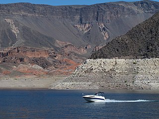
Lake Mead National Recreation Area is a U.S. national recreation area in southeastern Nevada and northwestern Arizona. Operated by the National Park Service, Lake Mead NRA follows the Colorado River corridor from the westernmost boundary of Grand Canyon National Park to just north of the cities of Laughlin, Nevada and Bullhead City, Arizona. It includes all of the eponymous Lake Mead as well as the smaller Lake Mohave – reservoirs on the river created by Hoover Dam and Davis Dam, respectively – and the surrounding desert terrain and wilderness.

<span class="mw-page-title-main">Trail Ridge Road</span> Colorado Scenic and Historic Byway

Trail Ridge Road is the name for the 48-mile (77 km) stretch of U.S. Highway 34 that traverses Rocky Mountain National Park from Estes Park, Colorado in the east to Grand Lake, Colorado in the west. Together with the connecting 6.9-mile (11 km) Beaver Meadow Road, Trail Ridge Road forms the 55-mile (89 km) Trail Ridge Road/Beaver Meadow National Scenic Byway, an All-American Road. With a high point at 12,183 feet (3,713 m) elevation, Trail Ridge Road is the highest continuous paved road in North America. The higher portion of Trail Ridge Road is closed from October to May.

<span class="mw-page-title-main">Walnut Canyon National Monument</span> Protected area in Coconino County, Arizona

Walnut Canyon National Monument is a United States National Monument located about 10 mi (16 km) southeast of downtown Flagstaff, Arizona, near Interstate 40. The canyon rim elevation is 6,690 ft (2,040 m); the canyon's floor is 350 ft (110 m) lower. A 0.9 mi (1.4 km) long loop trail descends 185 ft (56 m) into the canyon passing 25 cliff dwelling rooms constructed by the Sinagua, a pre-Columbian cultural group that lived in Walnut Canyon from about 1100 to 1250 AD. Other contemporary habitations of the Sinagua people are preserved in the nearby Tuzigoot and Montezuma Castle national monuments.

<span class="mw-page-title-main">Bright Angel Trail</span> Grand Canyon hiking trail

The Bright Angel Trail is a hiking trail located in Grand Canyon National Park in the U.S. state of Arizona.

<span class="mw-page-title-main">Phantom Ranch</span> Historic Grand Canyon lodging

Phantom Ranch is a lodge inside Grand Canyon National Park in Arizona. It sits at the bottom of Grand Canyon, on the east side of Bright Angel Creek, a little over half a mile north of the Creek's confluence with the Colorado River. Opened in 1922, Phantom Ranch is a member of Historic Hotels of America, the official program of the National Trust for Historic Preservation.

<span class="mw-page-title-main">Hermits Rest</span> NRHP site in Coconino County, Arizona

Hermits Rest is a structure built in 1914 at the western end of Hermit Road at the south rim of the Grand Canyon in Arizona, United States. The Hermit Trail, a hiking trail that extends to the Colorado River, begins about ¼ mile beyond the shuttle bus stop at Hermits Rest. Hermits Rest also represents the western terminus of the Rim Trail. The location was named for Louis Boucher. Around 1891, Boucher – a Canadian-born prospector – staked claims below present-day Hermits Rest. With help, Boucher carved the aforementioned trail into the canyon, and for years lived alone at nearby Dripping Springs. The main structure currently standing at Hermits Rest was designed by architect Mary Colter. Hermits Rest is the westernmost point on the canyon's south rim that is accessible by paved road. It was built as a rest area for tourists on coaches operated by the Fred Harvey Company on the way to the now-vanished Hermit Camp. The building was designed to appear to be a natural stone formation, closely tied to the land. Colter selected furnishings that are included in the National Historic Landmark designation.

<span class="mw-page-title-main">North Kaibab Trail</span> Grand Canyon hiking trail

The North Kaibab Trail is a hiking trail in the North Rim side of the Grand Canyon, in Grand Canyon National Park, located in the U.S. state of Arizona.

<span class="mw-page-title-main">Grand Canyon Lodge</span> NRPH building in Coconino County, Arizona

The Grand Canyon Lodge is a hotel and cabins complex at Bright Angel Point on the North Rim of the Grand Canyon. It was designed by Gilbert Stanley Underwood, who designed a number of other hotels in national parks for the Utah Parks Company and other concessioners. Built in 1927–28, the Grand Canyon Lodge resort complex consists of the Main Lodge building, 23 deluxe cabins, and 91 standard cabins, some of which were moved to the north rim campground in 1940. All guests are housed in cabins detached from the main lodge, which serves as a dining, concessions and service facility. Constructed of native Kaibab limestone and timber, the complex was designed to harmonize with its rocky and forested setting. The Grand Canyon Lodge complex is notable for its setting and rustic design, as well as its status as the only complete surviving lodge and cabin complex in the national parks.

<span class="mw-page-title-main">Grand Canyon Village Historic District</span> Historic district in Arizona, United States

Grand Canyon Village Historic District comprises the historic center of Grand Canyon Village, on the South Rim of the Grand Canyon in Grand Canyon National Park, Arizona. The district includes numerous landmark park structures, many of which are National Historic Landmarks themselves, or are listed on the National Register of Historic Places. The town design as a whole is also significant for its attention to integration with the Grand Canyon landscape, its incorporation of National Park Service Rustic design elements, and for the idiosyncratic design of park concessioner structures such as the El Tovar Hotel.

<span class="mw-page-title-main">Grand Loop Road</span> United States historic place

The Grand Loop Road is a historic district which encompasses the primary road system in Yellowstone National Park. Much of the 140-mile (230 km) system was originally planned by Captain Hiram M. Chittenden of the US Army Corps of Engineers in the early days of the park, when it was under military administration. The Grand Loop Road provides access to the major features of the park, including the Upper, Midway and Lower geyser basins, Mammoth Hot Springs, Tower Fall, the Grand Canyon of the Yellowstone and Yellowstone Lake.

<span class="mw-page-title-main">North Entrance Road Historic District</span> Historic district in Montana, United States

The North Entrance Road Historic District comprises Yellowstone National Park's North Entrance Road from Gardiner, Montana to the park headquarters at Mammoth Hot Springs, Wyoming, a distance of a little over five miles (8 km). The North Entrance Road was the first major road in the park, necessary to join the U.S. Army station at Fort Yellowstone to the Northern Pacific Railroad station at Gardiner. The road includes the Roosevelt Arch at the northern boundary of the park and winds through rolling terrain before crossing the Gardner River and joining the Grand Loop Road.

<span class="mw-page-title-main">Trans-Canyon Telephone Line, Grand Canyon National Park</span> United States historic place

The Trans-Canyon Telephone line crossed the Grand Canyon from the South Rim to the North Rim via the Inner Canyon. On the south side of the Canyon, the phone line left the South Rim developed area near Bright Angel Lodge, went down Pipe Creek, and crossed the Colorado River. On the north side, the phone line followed Bright Angel Creek up to the rim to the Wylie Way Tourist Camp before the construction of the Grand Canyon Inn. The line was in place by 1924 and was altered in 1935 and again in 1938-39 by the Civilian Conservation Corps. It has been unchanged since then. Telephone lines were supported using 592 assemblies of 2-inch (5.1 cm) galvanized pipes and fittings, which could be easily transported and assembled with minimal impact to the canyon environment. It was a rare surviving example of open-wire copper-weld technology. The line extended for 18 miles (29 km), paralleling the Bright Angel Trail and the North Kaibab Trail, providing a direct link between the North and South Rims, as well as the Inner Canyon. A spur line ran along the Tonto Trail to the Tipoff.

<span class="mw-page-title-main">Serpents Trail</span> United States historic place

The Serpents Trail, also known as the Trail of the Serpents and the Serpentine Trail, is a trail within the Colorado National Monument in Mesa County, Colorado, United States, that is listed on the National Register of Historic Places.

<span class="mw-page-title-main">Historical buildings and structures of Zion National Park</span> United States historic place

The historical buildings and structures of Zion National Park represent a variety of buildings, interpretive structures, signs and infrastructure associated with the National Park Service's operations in Zion National Park, Utah. Structures vary in size and scale from the Zion Lodge to road culverts and curbs, nearly all of which were designed using native materials and regional construction techniques in an adapted version of the National Park Service Rustic style. A number of the larger structures were designed by Gilbert Stanley Underwood, while many of the smaller structures were designed or coordinated with the National Park Service Branch of Plans and Designs. The bulk of the historic structures date to the 1920s and 1930s. Most of the structures of the 1930s were built using Civilian Conservation Corps labor.

<span class="mw-page-title-main">Bright Angel Lodge</span> United States historic place

Bright Angel Lodge is a hotel complex at the South Rim of the Grand Canyon in Grand Canyon National Park, Arizona. Designed by architect Mary Jane Colter, the lodge is a complex of cabins around a central lodge building, directly on the edge of the canyon. The rustic lodge complex is a major contributing building in the Grand Canyon Village National Historic Landmark District. In 2022, Bright Angel Lodge is also a member of Historic Hotels of America, an official program of the National Trust for Historic Preservation.

Architects of the National Park Service are the architects and landscape architects who were employed by the National Park Service (NPS) starting in 1918 to design buildings, structures, roads, trails and other features in the United States National Parks. Many of their works are listed on the National Register of Historic Places, and a number have also been designated as National Historic Landmarks.

<span class="mw-page-title-main">Black Suspension Bridge</span> Pedestrian bridge over the Colorado River in the Grand Canyon

The Black Suspension Bridge spans the Colorado River in the inner canyon of Grand Canyon National Park. The span length is 440 feet (130 m). The bridge is part of the South Kaibab Trail and is the river crossing used by mules going to Phantom Ranch. The Black Bridge and Silver Bridge, located about 700 metres (2,300 ft) downstream, are the only spans in hundreds of river miles.

<span class="mw-page-title-main">Dead Indian Canyon Bridge</span> United States historic place

The Dead Indian Canyon Bridge, near Desert View in Coconino County, Arizona, is a Warren truss bridge built in 1933 as part of developing public highway approach from the east to the south rim of the Grand Canyon. It was listed on the National Register of Historic Places in 1988.

References

  1. Grand Canyon in United States of America Archived July 24, 2019, at the Wayback Machine . protectedplanet.net. United Nations Environment World Conservation Monitoring Centre and the IUCN's World Commission on Protected Areas. Retrieved July 25, 2019.
  2. "Grand Canyon National Park Visitor Center". Geographic Names Information System . United States Geological Survey, United States Department of the Interior . Retrieved August 14, 2011.
  3. "Listing of acreage – December 31, 2011" (XLSX). Land Resource Division, National Park Service. Retrieved March 7, 2012. (National Park Service Acreage Reports)
  4. "Annual Park Ranking Report for Recreation Visits in: 2023". nps.gov. National Park Service. Retrieved April 11, 2024.
  5. "Top 10 most visited national parks". Travel. March 27, 2024. Retrieved March 27, 2024.
  6. "Grand Canyon Centennial History". Time . Retrieved April 19, 2019.
  7. Anderson, Michael F. "Polishing the Jewel: An Administrative History of Grand Canyon National Park" (PDF). Grand Canyon Association. Archived (PDF) from the original on April 2, 2015. Retrieved December 7, 2015.
  8. Pryputniewicz, Vanya; Peterson, Peter. "Grand Canyon National Park Presents Living History Performance of President Theodore Roosevelt". nps.gov. Retrieved February 27, 2015.
  9. "Archived copy" (PDF). Archived from the original (PDF) on April 2, 2015. Retrieved September 21, 2014.{{cite web}}: CS1 maint: archived copy as title (link)
  10. 35  Stat.   2175
  11. Yanagihara, Wendy; Denniston, Jennifer (2008). Grand Canyon National Park. Lonely Planet. p. 95. ISBN   978-1741044836.
  12. The National Parks: Index 2012–2016 (PDF). Washington, D.C.: National Park Service. Archived (PDF) from the original on November 13, 2018. Retrieved November 19, 2018.
  13. "Overflights – Documents – Grand Canyon National Park (U.S. National Park Service)".
  14. "Grand Canyon Coin Introduced" (PDF). United States Mint . 2010. Archived (PDF) from the original on February 27, 2015. Retrieved February 27, 2015. The Grand Canyon National Park Quarter is the fourth coin of 2010 in the America the Beautiful Quarters® Program. The reverse image features a view of the granaries above the Nankoweap Delta in Marble Canyon near the Colorado River.
  15. "100th Anniversary Celebration Took Place in 2019".
  16. "DOI Regions – Bureau Executive Assignments" (PDF). Archived (PDF) from the original on July 3, 2021.
  17. "Management – Grand Canyon National Park". U.S. National Park Service. Retrieved April 27, 2022.
  18. Anderson, Michael F. (2000). Polishing the Jewel: An Administrative History of Grand Canyon National Park. Grand Canyon Association. p. 90.
  19. Kirby-Lynn Shedlowski (May 17, 2016). "Superintendent Dave Uberuaga Announces Retirement". National Park Service. Retrieved January 29, 2024.
  20. Felicia Fonseca (March 14, 2019). "1st female superintendent of Grand Canyon park steps down". AP News. Retrieved January 29, 2024.
  21. "Ed Keable Named Superintendent of Grand Canyon National Park". National Park Service. April 3, 2020. Retrieved January 29, 2024.
  22. 1 2 "North Rim". Grand Canyon National Park. National Park Service. Retrieved November 18, 2018.
  23. Rand McNally; National Park Guide; Michael Frome; Rand McNally & Company, Chicago; 1970; p. 47
  24. Rand McNally (2010). Road Atlas. United States, Canada, Mexico.{{cite book}}: CS1 maint: location missing publisher (link)
  25. "South Rim Pocket Map and Services Guide". National Park Service. Retrieved June 20, 2020.
  26. 1 2 National Park Service (1972). South Rim. Grand Canyon National Park, Arizona: US Government Printing Office.
  27. 1 2 3 4 "Lodging". National Park Service. Retrieved June 25, 2021.
  28. "Campgrounds – North Rim". National Park Service. Retrieved December 7, 2015.
  29. "USDA Interactive Plant Hardiness Map". United States Department of Agriculture . Retrieved July 5, 2019.
  30. "NOWData – NOAA Online Weather Data". National Oceanic and Atmospheric Administration . Retrieved June 8, 2021.
  31. "Summary of Monthly Normals 1991-2020". National Oceanic and Atmospheric Administration . Retrieved June 8, 2021.
  32. "Grand Canyon National Park, Arizona - Monthly weather forecast and Climate data". Weather Atlas. Retrieved May 30, 2023.
  33. "Archived copy" (PDF). Archived from the original (PDF) on June 29, 2017. Retrieved November 3, 2017.{{cite web}}: CS1 maint: archived copy as title (link)
  34. Grand Canyon West. "Grand Canyon Helicopter & Aerial Tours".
  35. "Home". Grand Canyon Conservancy. Retrieved April 27, 2022.
  36. "National Archives NextGen Catalog". catalog.archives.gov. Retrieved March 27, 2024.
  37. "Mary Colter and Her Buildings at Grand Canyon (U.S. National Park Service)". www.nps.gov. Retrieved March 27, 2024.
External image
Searchtool.svg Public domain images from the National Park Service.