History of the Grand Canyon area

Last updated

Foot of Toroweap Looking East by William H. Holmes (1882). Artwork such as this was used to popularize the Grand Canyon area. Duttonnp000077AAA2.jpg
Foot of Toroweap Looking East by William H. Holmes (1882). Artwork such as this was used to popularize the Grand Canyon area.

The known human history of the Grand Canyon area stretches back 10,500 years, when the first evidence of human presence in the area is found. Native Americans have inhabited the Grand Canyon and the area now covered by Grand Canyon National Park for at least the last 4,000 of those years. Ancestral Pueblo peoples, first as the Basketmaker culture and later as the more familiar Pueblo people, developed from the Desert Culture as they became less nomadic and more dependent on agriculture. A similar culture, the Cochimi also lived in the canyon area. Drought in the late 13th century likely caused both groups to move on. Other people followed, including the Paiute, Cerbat, and the Navajo, only to be later forced onto reservations by the United States Government.

Contents

In September 1540, under direction by conquistador Francisco Vásquez de Coronado to find the fabled Seven Cities of Gold, Captain García López de Cárdenas led a party of Spanish soldiers with Hopi guides to the Grand Canyon. More than 200 years passed before two Spanish priests became the second party of non-Native Americans to see the canyon. U.S. Army Major John Wesley Powell led the 1869 Powell Geographic Expedition through the canyon on the Colorado River. This and later study by geologists uncovered the geology of the Grand Canyon area and helped to advance that science. In the late 19th century, the promise of mineral resources—mainly copper and asbestos—renewed interest in the region. The first pioneer settlements along the rim came in the 1880s.

Early residents soon realized that tourism was destined to be more profitable than mining, and by the turn of the 20th century the Grand Canyon was a well-known tourist destination. Most visitors made the gruelling trip from nearby towns to the South Rim by stagecoach. In 1901 the Grand Canyon Railway was opened from Williams, Arizona, to the South Rim, and the development of formal tourist facilities, especially at Grand Canyon Village, increased dramatically. The Fred Harvey Company developed many facilities at the Grand Canyon, including the luxury El Tovar Hotel on the South Rim in 1905 and Phantom Ranch in the Inner Gorge in 1922. Although first afforded federal protection in 1893 as a forest reserve and later as a U.S. National Monument, the Grand Canyon did not achieve U.S. National Park status until 1919, three years after the creation of the National Park Service. Today, Grand Canyon National Park receives about five million visitors each year, a far cry from the annual visitation of 44,173 in 1919.

Early history

Split-twig figurine from the Grand Canyon Spilt-twig figurine from the Grand Canyon.jpg
Split-twig figurine from the Grand Canyon

Current archaeological evidence suggests that humans inhabited the Grand Canyon area as far back as 4,000 years ago [1] and at least were passers-through for 6,500 years before that. [2] Radiocarbon dating of artifacts found in limestone caves in the inner canyon indicate ages of 3,000 to 4,000 years. [1] In the 1950s split-twig animal figurines were found in the Redwall Limestone cliffs of the Inner Gorge that were dated in this range. These animal figurines are a few inches (7 to 8 cm) in height and made primarily from twigs of willow or cottonwood. [1] This and other evidence suggests that these inner canyon dwellers were part of Desert Culture; a group of semi-nomadic hunter-gatherer Native American. The Ancestral Pueblo of the Basketmaker III Era (also called the Histatsinom, meaning "people who lived long ago") evolved from the Desert Culture sometime around 500 BCE. [1] This group inhabited the rim and inner canyon and survived by hunting and gathering along with some limited agriculture. Noted for their basketmaking skills (hence their name), they lived in small communal bands inside caves and circular mud structures called pithouses. Further refinement of agriculture and technology led to a more sedentary and stable lifestyle for the Ancestral Pueblo starting around 500 CE. [1] Contemporary with the flourishing of Ancestral Pueblo culture, another group, called the Cohonina lived west of the current site of Grand Canyon Village. [1]

Ancestral Pueblo in the Grand Canyon area started to use stone in addition to mud and poles to erect above-ground houses sometime around 800 CE. [1] Thus the Pueblo period of Ancestral Pueblo culture was initiated. In summer, the Puebloans migrated from the hot inner canyon to the cooler high plateaus and reversed the journey for winter. [1] Large granaries and multi-room pueblos survive from this period. There are around 2,000 known Ancestral Pueblo archaeological sites in park boundaries. The most accessible site is Tusayan Pueblo, which was constructed sometime c.1185 and housed 30 or so people. [3]

Ancestral Pueblo food storage building ruins at Tusayan Pueblo Tusayan at the Grand Canyon-storage areas.jpeg
Ancestral Pueblo food storage building ruins at Tusayan Pueblo

Large numbers of dated archaeological sites indicate that the Ancestral Pueblo and the Cohonina flourished until about 1200 CE. [1] But something happened a hundred years later that forced both of these cultures to move away. Several lines of evidence led to a theory that climate change caused a severe drought in the region from 1276 to 1299, forcing these agriculture-dependent cultures to move on. [4] Many Ancestral Pueblo relocated to the Rio Grande and the Little Colorado River drainages, where their descendants, the Hopi and the 19 Pueblos of New Mexico, now live. [3]

For approximately one hundred years the canyon area was uninhabited by humans. [1] Paiute from the east and Cerbat from the west were the first humans to reestablish settlements in and around the Grand Canyon. [1] The Paiute settled the plateaus north of the Colorado River and the Cerbat built their communities south of the river, on the Coconino Plateau. The Navajo, or the Diné, arrived in the area later.

All three cultures were stable until the United States Army moved them to Indian reservations in 1882 as part of the removal efforts that ended the Indian Wars. [1] The Havasupai and Hualapai are descended from the Cerbat and still live in the immediate area. The village of Supai in the western part of the current park has been occupied for centuries. Adjacent to the eastern part of the park is the Navajo Nation, the largest reservation in the United States.

European exploration

Spanish

The first Europeans reached the Grand Canyon in September 1540. [1] It was a group of about 13 Spanish soldiers led by García López de Cárdenas, dispatched from the army of Francisco Vásquez de Coronado on its quest to find the fabulous Seven Cities of Gold. [2] [5] [6] The group was led by Hopi guides and, assuming they took the most likely route, must have reached the canyon at the South Rim, probably between today's Desert View and Moran Point. According to Castañeda, he and his company came to a point "from whose brink it looked as if the opposite side must be more than three or four leagues by air line." [7]

The report indicates that they greatly misjudged the proportions of the gorge. On the one hand, they estimated that the canyon was about three to four leagues wide (13–16 km, 8–10 mi), which is quite accurate. [5] At the same time, however, they believed that the river, which they could see from above, was only 2 m (6 ft) wide (in reality it is about a hundred times wider). [5] Being in dire need of water, and wanting to cross the giant obstacle, the soldiers started searching for a way down to the canyon floor that would be passable for them along with their horses. After three full days, they still had not been successful, and it is speculated that the Hopi, who probably knew a way down to the canyon floor, were reluctant to lead them there. [5]

As a last resort, Cárdenas finally commanded the three lightest and most agile men of his group to climb down by themselves (their names are given as Pablo de Melgosa, Juan Galeras, and an unknown, third soldier). [5] After several hours, the men returned, reporting that they had only made one third of the distance down to the river, and that "what seemed easy from above was not so". [5] Furthermore, they claimed that some of the boulders which they had seen from the rim, and estimated to be about as tall as a man, were in fact bigger than the Great Tower of Seville, at 104.1 m (342 ft). Cárdenas finally had to give up and returned to the main army. His report of an impassable barrier forestalled further visitation to the area for two hundred years.

Only in 1776 did two Spanish Priests, Fathers Francisco Atanasio Domínguez and Silvestre Vélez de Escalante travel along the North Rim again, together with a group of Spanish soldiers, exploring southern Utah in search of a route from Santa Fe, New Mexico to Monterey, California. [1] Also in 1776, Fray Francisco Garces, a Franciscan missionary, spent a week near Havasupai, unsuccessfully attempting to convert a band of Native Americans. He described the canyon as "profound". [8]

Americans

James Ohio Pattie and a group of American trappers and mountain men were probably the next Europeans to reach the canyon in 1826, [9] although there is little supporting documentation.

The signing of the Treaty of Guadalupe Hidalgo in 1848 ceded the Grand Canyon region to the United States. Jules Marcou of the Pacific Railroad Survey made the first geologic observations of the canyon and surrounding area in 1856. [2]

The 54-foot (16 m) paddle wheeler Explorer in the Lt. Joseph Ives expedition up the Colorado River. Period engraving. Explorer boat from Ives Expedition.jpg
The 54-foot (16 m) paddle wheeler Explorer in the Lt. Joseph Ives expedition up the Colorado River. Period engraving.

Jacob Hamblin (a Mormon missionary) was sent by Brigham Young in the 1850s to locate easy river crossing sites in the canyon. [10] Building good relations with local Native Americans and white settlers, he discovered Lee's Ferry in 1858 and Pierce Ferry (later operated by, and named for, Harrison Pierce)—the only two sites suitable for ferry operation. [11]

In 1857 Edward Fitzgerald Beale led an expedition to survey a wagon road from Fort Defiance, Arizona to the Colorado River. [12] On September 19 near present-day National Canyon they came upon what May Humphreys Stacey described in his journal as "a wonderful canyon four thousand feet deep. Everyone (in the party) admitted that he never before saw anything to match or equal this astonishing natural curiosity." [13]

A U.S. War Department expedition led by Lt. Joseph Ives was launched in 1857 to investigate the area's potential for natural resources, to find railroad routes to the west coast, and assess the feasibility of an up-river navigation route from the Gulf of California. [2] The group traveled in a stern wheeler steamboat named Explorer. After two months and 350 miles (560 km) of difficult navigation, his party reached Black Canyon some two months after George Johnson. [14] In the process, the Explorer struck a rock and was abandoned. The group later traveled eastwards along the South Rim of the Grand Canyon.

John Wesley Powell in 1869 John Wesley Powell in 1869.jpg
John Wesley Powell in 1869

A man of his time, Ives discounted his own impressions on the beauty of the canyon and declared it and the surrounding area as "altogether valueless", remarking that his expedition would be "the last party of whites to visit this profitless locality". [15] Attached to Ives' expedition was geologist John Strong Newberry who had a very different impression of the canyon. [2] After returning, Newberry convinced fellow geologist John Wesley Powell that a boat run through the Grand Canyon to complete the survey would be worth the risk. [16] [lower-alpha 1] Powell was a major in the United States Army and was a veteran of the American Civil War, a conflict that cost him his right forearm in the Battle of Shiloh. [2]

More than a decade after the Ives Expedition and with help from the Smithsonian Institution, Powell led the first of the Powell Expeditions to explore the region and document its scientific offerings. [6] On May 24, 1869, the group of nine men set out from Green River Station in Wyoming down the Colorado River and through the Grand Canyon. [2] This first expedition was poorly funded and consequently no photographer or graphic artist was included. While in the Canyon of Lodore one of the group's four boats capsized, spilling most of their food and much of their scientific equipment into the river. This shortened the expedition to one hundred days. Tired of being constantly cold, wet and hungry and not knowing they had already passed the worst rapids, three of Powell's men climbed out of the canyon in what is now called Separation Canyon. [18] Once out of the canyon, all three were reportedly killed by Shivwits band Paiutes who thought they were miners that recently molested and killed a female Shivwit. [18] All those who stayed with Powell survived and that group successfully ran most of the canyon.

Noon Day Rest in Marble Canyon from the second Powell Expedition, c. 1872 'Noon Day Rest in Marble Canyon' from the second Powell Expedition 1872.jpg
Noon Day Rest in Marble Canyon from the second Powell Expedition, c. 1872

Two years later a much better-funded Powell-led party returned with redesigned boats and a chain of several supply stations along their route. This time, photographer E.O. Beaman and 17-year-old artist Frederick Dellenbaugh were included. [18] Beaman left the group in January 1872 over a dispute with Powell and his replacement, James Fennemore, quit August that same year due to poor health, leaving boatman John K. Hillers as the official photographer (nearly one ton of photographic equipment was needed on site to process each shot). [19] Famed painter Thomas Moran joined the expedition in the summer of 1873, after the river voyage and thus only viewed the canyon from the rim. His 1873 painting "Chasm of the Colorado" was bought by the United States Congress in 1874 and hung in the lobby of the Senate. [20]

The Powell expeditions systematically cataloged rock formations, plants, animals, and archaeological sites. Photographs and illustrations from the Powell expeditions greatly popularized the canyonland region of the southwest United States, especially the Grand Canyon (appreciating this, Powell added increasing resources to that aspect of his expeditions). Powell later used these photographs and illustrations in his lecture tours, making him a national figure. Rights to reproduce 650 of the expeditions' 1,400 stereographs were sold to help fund future Powell projects. [21] In 1881 he became the second director of the U.S. Geological Survey.

Clarence Dutton Clarence Dutton.jpg
Clarence Dutton

Geologist Clarence Dutton followed up on Powell's work in 1880–1881 with the first in-depth geological survey of the newly formed U.S. Geological Survey. [22] Painters Thomas Moran and William Henry Holmes accompanied Dutton, who was busy drafting detailed descriptions of the area's geology. The report that resulted from the team's effort was titled A Tertiary History of The Grand Canyon District, with Atlas and was published in 1882. [22] This and later study by geologists uncovered the geology of the Grand Canyon area and helped to advance that science. Both the Powell and Dutton expeditions helped to increase interest in the canyon and surrounding region.

The Brown-Stanton expedition was started in 1889 to survey the route for a "water-level" railroad line through the canyons of the Colorado River to the Gulf of California. [23] The proposed Denver, Colorado Canyon, and Pacific Railway was to carry coal from mines in Colorado. Expedition leader Frank M. Brown, his chief engineer Robert Brewster Stanton, and 14 other men set out in six boats from Green River, Utah, on May 25, 1889. [23] Brown and two others drowned near the head of Marble Canyon. The expedition was restarted by Stanton from Dirty Devil River (a tributary of Glen Canyon) on November 25 and traveled through the Grand Canyon. [23] The expedition reached the Gulf of California on April 26, 1890 but the railroad was never built.

Prospectors in the 1870s and 1880s staked mining claims in the canyon. [22] They hoped that previously discovered deposits of asbestos, copper, lead, and zinc would be profitable to mine. Access to and from this remote region and problems getting ore out of the canyon and its rock made the whole exercise not worth the effort. Most moved on, but some stayed to seek profit in the tourist trade. Their activities did improve pre-existing Indian trails, such as Bright Angel Trail. [3]

Tourism

Transportation

A group photo of passengers who rode on the first run of the Grand Canyon Railway First run of Grand Canyon Railway.jpg
A group photo of passengers who rode on the first run of the Grand Canyon Railway

A rail line to the largest city in the area, Flagstaff, was completed in 1882 by the Santa Fe Railroad. [24] Stage coaches started to bring tourists from Flagstaff to the Grand Canyon the next year—an eleven-hour trip greatly reduced in 1901 when a spur of the Santa Fe Railroad to Grand Canyon Village was completed. [22] The first scheduled train with paying passengers of the Grand Canyon Railway arrived from Williams, Arizona, on September 17 that year. [24] The 64-mile (103 km) long trip cost $3.95 ($124.71 as of 2024), and naturalist John Muir later commended the railroad for its limited environmental impact. [24]

The first automobile was driven to the Grand Canyon in January 1902. Oliver Lippincott from Los Angeles, drove his American Bicycle Company built Toledo steam car to the South Rim from Flagstaff. Lippincott, Al Doyle a guide from Flagstaff and two writers set out on the afternoon of January 2, anticipating a seven-hour journey. Two days later, the hungry and dehydrated party arrived at their destination; the countryside was just too rough for the ten-horsepower (7 kW) auto. Winfield Hoggaboon, one of the writers on the trip, wrote an amusing and detailed three page article in the Los Angeles Herald Illustrated Magazine on February 2, 1902, "To the Grand Canyon by Automobile". A three-day drive from Utah in 1907 was required to reach the North Rim for the first time. [24]

Competition with the automobile forced the Santa Fe Railroad to cease operation of the Grand Canyon Railway in 1968 (only three passengers were on the last run). The railway was restored and service reintroduced in 1989, and it has since carried hundreds of passengers a day. Trains remained the preferred way to travel to the canyon until they were surpassed by the auto in the 1930s. By the early 1990s more than a million automobiles per year visited the park.

West Rim Drive was completed in 1912. In the late 1920s the first rim-to-rim access was established by the North Kaibab suspension bridge over the Colorado River. [22] Paved roads did not reach the less popular and more remote North Rim until 1926, and that area, being higher in elevation, is closed due to winter weather from November to April. Construction of a road along part of the South Rim was completed in 1935. [22]

Air pollution

The primary mobile source of Grand Canyon haze, the automobile, is currently regulated under a series of federal, state and local initiatives. The Grand Canyon Visibility Transport Commission cites U.S. government laws regulating automobile emissions and gasoline standards, often slow to change because of the automobile industry's planning schedule, as a primary contributor to air quality issues in the area. [25] They advocate policies leaning toward stricter emission standards via cleaner burning fuel and improved automobile emissions technology.

Air pollution from those vehicles and wind-blown pollution from Las Vegas, Nevada area has reduced visibility in the Grand Canyon and vicinity. During the past decade, various regional coal-fired electric utilities having little or no pollution control equipment were targeted as the primary stationary sources of Grand Canyon air pollution. [26] In the 1980s the Navajo Generating Station at Page, Arizona, (15 miles away) was identified as the primary source for anywhere from fifty percent to ninety percent of the Grand Canyon's air quality problems. [25] In 1999, the Mohave Generating Station in Laughlin, Nevada, (75) miles away settled a long-standing lawsuit and agreed to install end-of-point sulfur scrubbers on its smoke stacks.

Closer to home, there is little disagreement that the most visible of the park's visibility problems stems from the park's popularity. On any given summer day the park is filled to capacity, or over-capacity. Basically the problem boils down to too many private automobiles vying for too few parking spaces. Emissions from all those automobiles and tour buses contributes greatly to air pollution problems.

Accommodations

John D.Lee (Utah State Historical Society) John D. Lee.jpg
John D.Lee (Utah State Historical Society)

John D. Lee was the first person who catered to travelers to the canyon. In 1872 he established a ferry service at the confluence of the Colorado and Paria rivers. Lee was in hiding, having been accused of leading the Mountain Meadows massacre in 1857. He was tried and executed for this crime in 1877. During his trial he played host to members of the Powell Expedition who were waiting for their photographer, Major James Fennemore, to arrive (Fennemore took the last photo of Lee sitting on his own coffin). Emma, one of Lee's nineteen wives, continued the ferry business after her husband's death. In 1876 a man named Harrison Pierce established another ferry service at the western end of the canyon. [24]

The two-room Farlee Hotel opened in 1884 near Diamond Creek and was in operation until 1889. That year Louis Boucher opened a larger hotel at Dripping Springs. John Hance opened his ranch near Grandview to tourists in 1886 only to sell it nine years later in order to start a long career as a Grand Canyon guide (in 1896 he also became local postmaster).

William Wallace Bass William Wallace Bass.jpg
William Wallace Bass

William Wallace Bass opened a tent house campground in 1890. Bass Camp had a small central building with common facilities such as a kitchen, dining room, and sitting room inside. Rates were $2.50 a day ($84.78 as of 2024), and the complex was 20 miles (30 km) west of the Grand Canyon Railway's Bass Station (Ash Fort). Bass also built the stage coach road that he used to carry his patrons from the train station to his hotel. A second Bass Camp was built along the Shinumo Creek drainage. [24]

The Grand Canyon Hotel Company was incorporated in 1892 and charged with building services along the stage route to the canyon. [27] In 1896 the same man who bought Hance's Grandview ranch opened Bright Angel Hotel in Grand Canyon Village. [27] The Cameron Hotel opened in 1903, and its owner started to charge a toll to use the Bright Angel Trail. [27]

The El Tovar Hotel in the 1900s El Tovar Hotel in early 1900s.jpg
The El Tovar Hotel in the 1900s

Things changed in 1905 when the luxury El Tovar Hotel opened within steps of the Grand Canyon Railway's terminus. [22] El Tovar was named for Don Pedro de Tovar who tradition says is the Spaniard who learned about the canyon from Hopis and told Coronado. Charles Whittlesey designed the arts and crafts-styled rustic hotel complex, which was built with logs from Oregon and local stone at a cost of $250,000 for the hotel ($8,480,000 as of 2024) and another $50,000 for the stables ($1,700,000 as of 2024). [27] El Tovar was owned by Santa Fe Railroad and operated by its chief concessionaire, the Fred Harvey Company.

Fred Harvey hired Mary Elizabeth Jane Colter in 1902 as company architect. She was responsible for five buildings at the Grand Canyon: Hopi House (1905), Lookout Studio (1914), Hermit's Rest (1914), Desert View Watchtower (1932), and Bright Angel Lodge (1935). [3] She stayed with the company until her retirement in 1948.

A cable car system spanning the Colorado went into operation at Rust's Camp, located near the mouth of Bright Angel Creek, in 1907. Former U.S. President Theodore Roosevelt stayed at the camp in 1913. That, along with the fact that while president he declared Grand Canyon a U.S. National Monument in 1908, led to the camp being renamed Roosevelt's Camp. In 1922 the National Park Service gave the facility its current name, Phantom Ranch. [27]

Grand Canyon Lodge North face grand canyon lodge.jpg
Grand Canyon Lodge

In 1917 on the North Rim, W.W. Wylie built accommodations at Bright Angel Point. [22] The Grand Canyon Lodge opened on the North Rim in 1928. Built by a subsidiary of the Union Pacific Railroad called the Utah Parks Company, the lodge was designed by Gilbert Stanley Underwood who was also the architect for the Ahwahnee Hotel in California's Yosemite Valley. Much of the lodge was destroyed by fire in the winter of 1932, and a rebuilt lodge did not open until 1937. The facility is managed by TW Recreation Services. [24] Bright Angel Lodge and the Auto Camp Lodge opened in 1935 on the South Rim.

Activities

New hiking trails, along old Indian trails, were established during this time as well. The world-famous mule rides down Bright Angel Trail were mass-marketed by the El Tovar Hotel. By the early 1990s, 20,000 people per year made the journey into the canyon by mule, 800,000 by hiking, 22,000 passed through the canyon by raft, and another 700,000 tourists fly over it in air tours (fixed-wing aircraft and helicopter). Overflights were limited to a narrow corridor in 1956 after two planes crashed, killing all on board. In 1991 nearly 400 search and rescues were performed, mostly for unprepared hikers who suffered from heat exhaustion and dehydration while ascending from the canyon (normal exhaustion and injured ankles are also common in rescuees). [28] An IMAX theater just outside the park shows a reenactment of the Powell Expedition.

The Kolb Brothers, Emery and Ellsworth, built a photographic studio on the South Rim at the trailhead of Bright Angel Trail in 1904. Hikers and mule caravans intent on descending down the canyon would stop at the Kolb Studio to have their photos taken. The Kolb Brothers processed the prints before their customers returned to the rim. Using the newly invented Pathé Bray camera in 1911–12, they became the first to make a motion picture of a river trip through the canyon that itself was only the eighth such successful journey. From 1915 to 1975 the film they produced was shown twice a day to tourists with Emery Kolb at first narrating in person and later through tape (a feud with Fred Harvey prevented pre-1915 showings). [29]

Protection efforts

By the late 19th century, the conservation movement was increasing national interest in preserving natural wonders like the Grand Canyon. National Parks in Yellowstone and around Yosemite Valley were established by the early 1890s. U.S. Senator Benjamin Harrison introduced a bill in 1887 to establish a national park at the Grand Canyon. [18] The bill died in committee, but on February 20, 1893, Harrison (then President of the United States) declared the Grand Canyon to be a National Forest Preserve. [30] Mining and logging were allowed, but the designation did offer some protection. [18]

President Theodore Roosevelt visited the Grand Canyon in 1903. [22] An avid outdoorsman and staunch conservationist, he established the Grand Canyon Game Preserve on November 28, 1906. [30] Livestock grazing was reduced, but predators such as mountain lions, eagles, and wolves were eradicated. Roosevelt added adjacent national forest lands and re-designated the preserve a U.S. National Monument on January 11, 1908. [30] Opponents, such as holders of land and mining claims, blocked efforts to reclassify the monument as a National Park for 11 years. Grand Canyon National Park was finally established as the 17th U.S. National Park by an Act of Congress signed into law by President Woodrow Wilson on February 26, 1919. [30] The National Park Service declared the Fred Harvey Company to the official park concessionaire in 1920 and bought William Wallace Bass out of business.

An area of almost 310 square miles (800 km2) adjacent to the park was designated as a second Grand Canyon National Monument on December 22, 1932. [31] Marble Canyon National Monument was established on January 20, 1969, and covered about 41 square miles (105 km2). [31] An act signed by President Gerald Ford on January 3, 1975, doubled the size of Grand Canyon National Park by merging these adjacent national monuments and other federal land into it. That same act gave Havasu Canyon back to the Havasupai tribe. [22] From that point, the park stretched along a 278-mile (447 km) segment of the Colorado River from the southern border of Glen Canyon National Recreation Area to the eastern boundary of Lake Mead National Recreation Area. [31] Grand Canyon National Park was designated a World Heritage Site on October 24, 1979. [32]

In 1935, Hoover Dam started to impound Lake Mead south of the canyon. [16] Conservationists lost a battle to save upstream Glen Canyon from becoming a reservoir. The Glen Canyon Dam was completed in 1966 to control flooding and to provide water and hydroelectric power. [33] Seasonal variations of high flow and flooding in the spring and low flow in summer have been replaced by a much more regulated system. The much more controlled Colorado has a dramatically reduced sediment load, which starves beaches and sand bars. In addition, clearer water allows significant algae growth to occur on the riverbed, giving the river a green color.

With the advent of commercial flights, the Grand Canyon has been a popular site for aircraft overflights. However, a series of accidents resulted in the Overflights Act of 1987 by the United States Congress, which banned flights below the rim and created flight-free zones. [34] The tourist flights over the canyon have also created a noise problem, so the number of flights over the park has been restricted.

In 2008, the Grand Canyon Railway [35] and their parent company, Xanterra, decided to use only EMD f40ph diesel locomotives as their main motive power for their trackage, since they felt that their steam locomotives, as well as their Alco fa units, gave the environment more visible smoke. Not only that, but the steamers burn more oil than an average diesel unit, hence they can also be more pricey to operate and maintain. However, after a variety of formers protested to the GCR to bring back steam operations, [36] the GCR decided to bring back steam operations, as they converted both of their operational steamers, 29 and 4960, to burn recycled waste vegetable oil collected from nearby restaurants by third-party suppliers. [37]

See also

Notes

  1. Geologist Jules Marcou of the Pacific Railroad Survey made the first geologic observations of the canyon in 1856. [17]

Related Research Articles

<span class="mw-page-title-main">Grand Canyon National Park</span> National park in Arizona, United States

Grand Canyon National Park, located in northwestern Arizona, is the 15th site in the United States to have been named as a national park. The park's central feature is the Grand Canyon, a gorge of the Colorado River, which is often considered one of the Wonders of the World. The park, which covers 1,217,262 acres of unincorporated area in Coconino and Mohave counties, received more than 4.7 million recreational visitors in 2023. The Grand Canyon was designated a World Heritage Site by UNESCO in 1979. The park celebrated its 100th anniversary on February 26, 2019.

<span class="mw-page-title-main">Grand Canyon</span> Steep-sided canyon carved by the Colorado River in Arizona, United States

The Grand Canyon is a steep-sided canyon carved by the Colorado River in Arizona, United States. The Grand Canyon is 277 miles (446 km) long, up to 18 miles (29 km) wide and attains a depth of over a mile.

<span class="mw-page-title-main">Bryce Canyon National Park</span> National park in Utah, United States

Bryce Canyon National Park is an American national park located in southwestern Utah. The major feature of the park is Bryce Canyon, which despite its name, is not a canyon, but a collection of giant natural amphitheaters along the eastern side of the Paunsaugunt Plateau. Bryce is distinctive due to geological structures called hoodoos, formed by frost weathering and stream erosion of the river and lake bed sedimentary rock. The red, orange, and white colors of the rocks provide spectacular views for park visitors. Bryce Canyon National Park is much smaller and sits at a much higher elevation than nearby Zion National Park. The rim at Bryce varies from 8,000 to 9,000 feet.

<span class="mw-page-title-main">Grand Canyon Village, Arizona</span> Town in Arizona, United States

Grand Canyon Village is a census-designated place (CDP) located on the South Rim of the Grand Canyon, in Coconino County, Arizona, United States. Its population was 2,004 at the 2010 Census. Located in Grand Canyon National Park, it is wholly focused on accommodating tourists visiting the canyon. Its origins trace back to the railroad completed from Williams, to the canyon's South Rim by the Santa Fe Railroad in 1901. Many of the structures in use today date from that period. The village contains numerous landmark buildings, and its historic core is a National Historic Landmark District, designated for its outstanding implementation of town design.

<span class="mw-page-title-main">Southwestern United States</span> Geographical region of the United States

The Southwestern United States, also known as the American Southwest or simply the Southwest, is a geographic and cultural region of the United States that includes Arizona and New Mexico, along with adjacent portions of California, Colorado, Nevada, Oklahoma, Texas, and Utah. The largest cities by metropolitan area are Phoenix, Las Vegas, El Paso, Albuquerque, and Tucson. Before 1848, in the historical region of Santa Fe de Nuevo México as well as parts of Alta California and Coahuila y Tejas, settlement was almost non-existent outside of Nuevo México's Pueblos and Spanish or Mexican municipalities. Much of the area had been a part of New Spain and Mexico until the United States acquired the area through the Treaty of Guadalupe Hidalgo in 1848 and the smaller Gadsden Purchase in 1854.

<span class="mw-page-title-main">Little Colorado River</span> River in Arizona, United States

The Little Colorado River is a tributary of the Colorado River in the U.S. state of Arizona, providing the principal drainage from the Painted Desert region. Together with its major tributary, the Puerco River, it drains an area of about 26,500 square miles (69,000 km2) in eastern Arizona and western New Mexico. Although it stretches almost 340 miles (550 km), only the headwaters and the lowermost reaches flow year-round. Between St. Johns and Cameron, most of the river is a wide, braided wash, only containing water after heavy snowmelt or flash flooding.

<span class="mw-page-title-main">Geology of the Grand Canyon area</span> Aspect of geology

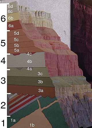
The geology of the Grand Canyon area includes one of the most complete and studied sequences of rock on Earth. The nearly 40 major sedimentary rock layers exposed in the Grand Canyon and in the Grand Canyon National Park area range in age from about 200 million to nearly 2 billion years old. Most were deposited in warm, shallow seas and near ancient, long-gone sea shores in western North America. Both marine and terrestrial sediments are represented, including lithified sand dunes from an extinct desert. There are at least 14 known unconformities in the geologic record found in the Grand Canyon.

The exposed geology of the Bryce Canyon area in Utah shows a record of deposition that covers the last part of the Cretaceous Period and the first half of the Cenozoic era in that part of North America. The ancient depositional environment of the region around what is now Bryce Canyon National Park varied from the warm shallow sea in which the Dakota Sandstone and the Tropic Shale were deposited to the cool streams and lakes that contributed sediment to the colorful Claron Formation that dominates the park's amphitheaters.

<span class="mw-page-title-main">Colorado Plateau</span> Plateau in southwestern United States

The Colorado Plateau, also known as the Colorado Plateau Province, is a physiographic and desert region of the Intermontane Plateaus, roughly centered on the Four Corners region of the southwestern United States. This province covers an area of 336,700 km2 (130,000 mi2) within western Colorado, northwestern New Mexico, southern and eastern Utah, northern Arizona, and a tiny fraction in the extreme southeast of Nevada. About 90% of the area is drained by the Colorado River and its main tributaries: the Green, San Juan, and Little Colorado. Most of the remainder of the plateau is drained by the Rio Grande and its tributaries.

<span class="mw-page-title-main">Mary Colter</span> American architect (1869–1958)

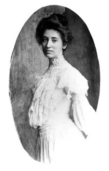
Mary Elizabeth Jane Colter was an American architect and designer. She was one of the very few female American architects in her day. She was the designer of many landmark buildings and spaces for the Fred Harvey Company and the Santa Fe Railroad, notably in Grand Canyon National Park. Her work had enormous influence as she helped to create a style, blending Spanish Colonial Revival and Mission Revival architecture with Native American motifs and Rustic elements, that became popular throughout the Southwest. Colter was a perfectionist, who spent a lifetime advocating and defending her aesthetic vision in a largely male-dominated field.

<span class="mw-page-title-main">Grand Canyon Railway</span> Historic railway to Grand Canyon National Park in Arizona

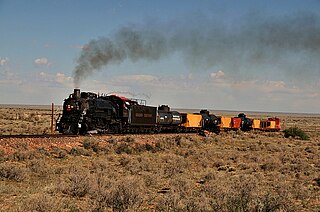
The Grand Canyon Railway is a heritage railroad which carries passengers between Williams, Arizona, and the South Rim of Grand Canyon National Park.

<span class="mw-page-title-main">El Tovar Hotel</span> NRHP building in Coconino County, Arizona

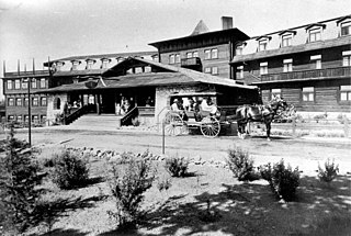
The El Tovar Hotel, also known simply as El Tovar, is a former Harvey House hotel situated directly on the south rim of the Grand Canyon in Arizona, United States.

<span class="mw-page-title-main">National Park Service rustic</span> Style of architecture developed in 20th century for the United States National Park Service

National Park Service rustic – sometimes colloquially called Parkitecture – is a style of architecture that developed in the early and middle 20th century in the United States National Park Service (NPS) through its efforts to create buildings that harmonized with the natural environment. Since its founding in 1916, the NPS sought to design and build visitor facilities without visually interrupting the natural or historic surroundings. The early results were characterized by intensive use of hand labor and a rejection of the regularity and symmetry of the industrial world, reflecting connections with the Arts and Crafts movement and American Picturesque architecture.

<span class="mw-page-title-main">Hopi House</span> United States historic place

Hopi House is located on the South Rim of the Grand Canyon, within Grand Canyon National Park in the U.S. state of Arizona. Built in 1904 as concessioner facilities at the South Rim were being developed, it is the first of eight projects at the Grand Canyon that were designed by architect Mary Colter, along with Bright Angel Lodge, Hermit's Rest, Lookout Studio, Phantom Ranch, Desert View Watchtower, Colter Hall and Victor Hall,. Hopi House was built by the Fred Harvey Company as a market for Native American crafts, made by artisans on the site. The Hopi, as the historic inhabitants of the area, were chosen as the featured artisans, and the building was designed to closely resemble a traditional Hopi pueblo. Hopi House opened on January 1, 1905, two weeks before the El Tovar Hotel, located just to the west, was opened.

<span class="mw-page-title-main">Grand Canyon Depot</span> Historic train station inside Grand Canyon National Park

Grand Canyon Depot, also known as Grand Canyon Railroad Station, was constructed in 1909–10 for the Atchison, Topeka and Santa Fe Railway at the South Rim of the Grand Canyon, in what is now Grand Canyon National Park. It is one of three remaining railroad depots in the United States built with logs as the primary structural material. The station is within 330 feet (100 m) of the rim of the canyon, opposite the El Tovar Hotel, also built by the railroad. The depot is designated a National Historic Landmark, is listed the National Register of Historic Places, and is included in the Grand Canyon Village National Historic Landmark District.

<span class="mw-page-title-main">Grand Canyon Village Historic District</span> Historic district in Arizona, United States

Grand Canyon Village Historic District comprises the historic center of Grand Canyon Village, on the South Rim of the Grand Canyon in Grand Canyon National Park, Arizona. The district includes numerous landmark park structures, many of which are National Historic Landmarks themselves, or are listed on the National Register of Historic Places. The town design as a whole is also significant for its attention to integration with the Grand Canyon landscape, its incorporation of National Park Service Rustic design elements, and for the idiosyncratic design of park concessioner structures such as the El Tovar Hotel.

<span class="mw-page-title-main">Zion National Park</span> National park in Utah, United States

Zion National Park is an American national park located in southwestern Utah near the town of Springdale. Located at the junction of the Colorado Plateau, Great Basin, and Mojave Desert regions, the park has a unique geography and a variety of life zones that allow for unusual plant and animal diversity. Numerous plant species as well as 289 species of birds, 75 mammals, and 32 reptiles inhabit the park's four life zones: desert, riparian, woodland, and coniferous forest. Zion National Park includes mountains, canyons, buttes, mesas, monoliths, rivers, slot canyons, and natural arches. The lowest point in the park is 3,666 ft (1,117 m) at Coalpits Wash and the highest peak is 8,726 ft (2,660 m) at Horse Ranch Mountain. A prominent feature of the 229-square-mile (590 km2) park is Zion Canyon, which is 15 miles (24 km) long and up to 2,640 ft (800 m) deep. The canyon walls are reddish and tan-colored Navajo Sandstone eroded by the North Fork of the Virgin River. The park attracted 5 million visitors in 2023.

<span class="mw-page-title-main">Bright Angel Lodge</span> United States historic place

Bright Angel Lodge is a hotel complex at the South Rim of the Grand Canyon in Grand Canyon National Park, Arizona. Designed by architect Mary Jane Colter, the lodge is a complex of cabins around a central lodge building, directly on the edge of the canyon. The rustic lodge complex is a major contributing building in the Grand Canyon Village National Historic Landmark District. In 2022, Bright Angel Lodge is also a member of Historic Hotels of America, an official program of the National Trust for Historic Preservation.

Pedro de Tovar was a Spanish explorer, military man and colonial administrator. He was part of Francisco Vazquez de Coronado's expedition and led the first expedition to Cibola in 1540. Tovar was also the first European to hear about the existence of the Grand Canyon, although he did not get to see it. He was also a member of Nuño Beltrán de Guzmán's troops during the conquest of Nueva Galicia, as well as collaborating in the colonization of Guadalajara and the foundation of Culiacán, in modern Mexico. After that, he was alcalde of Nueva Galicia and Culiacán.

<span class="mw-page-title-main">Shiva Temple (Grand Canyon)</span> Landform in the Grand Canyon, Arizona

Shiva Temple is a 7,646-foot-elevation (2,331-meter) summit located in the Grand Canyon, in Coconino County of Arizona, US. It is situated six miles north of Hopi Point overlook of the canyon's South Rim, about 2.5 miles southwest of North Rim's Tiyo Point, and two miles northwest of Isis Temple, where it towers 5,200 feet above the Colorado River. Shiva Temple is named for Shiva, the Hindu deity, destroyer of the universe. This name was applied by Clarence Dutton who began the tradition of naming geographical features in the Grand Canyon after mythological deities. Dutton believed Shiva Temple was the largest, grandest, and most majestic of the Grand Canyon buttes, with a broad, level, forested top. This mountain's name was officially adopted in 1906 by the U.S. Board on Geographic Names.

References

  1. 1 2 3 4 5 6 7 8 9 10 11 12 13 14 Tufts 1998 , p. 12
  2. 1 2 3 4 5 6 7 Kiver & Harris 1999 , p. 396
  3. 1 2 3 4 American Park Network
  4. O'Connor 1992 , p. 16
  5. 1 2 3 4 5 6 Castañeda 1596
  6. 1 2 Ranney, Wayne (April 2014). "A pre–21st century history of ideas on the origin of the Grand Canyon". Geosphere. 10 (2): 233–242. Bibcode:2014Geosp..10..233R. doi: 10.1130/ges00960.1 .
  7. Herbert E. Bolton (1964). Coronado: Knight of Pueblos and Plains. Albuquerque: The University of New Mexico Press, pp. 54, 139–140. [ ISBN missing ]
  8. Page Stegner (1994). Grand Canyon, The Great Abyss . HarperCollins. p.  25. ISBN   0-06-258564-9.
  9. Pattie, James Ohio; Thwaites, Reuben Gold; Flint, Timothy (1905). The Personal Narrative of James O. Pattie, of Kentucky: During an Expedition from St. Louis, Through the Vast Regions Between that Place and the Pacific Ocean, and Thence Back Through the City of Mexico to Vera Cruz, During Journeyings of Six Years, Etc. Vol. 18. Chicago: A.H. Clark. p. 14.
  10. Hamblin, Jacob; Little, James A. (1971). Jacob Hamblin, a Narrative of His Personal Experience, as a Frontiersman, Missionary to the Indians and Explorer, Disclosing Interpositions of Providence, Severe Privations, Perilous Situations and Remarkable Escapes. Ayer Publishing. p. 136. ISBN   0-8369-5899-3.
  11. Ward, Greg (2003). The rough guide to the Grand Canyon . Rough Guides. pp.  113, 251. ISBN   1-84353-052-X.
  12. Bonsal, Stephen (1912). Edward Fitzgerald Beale, a Pioneer in the Path of Empire, 1822–1903. New York: G. P. Putnam's sons. p.  208.
  13. Dodge, Bertha Sanford (1980). The Road West: Saga of the 35th Parallel (1st ed.). University of New Mexico Press. p. 123. ISBN   0-8263-0526-1.
  14. Rules and Regulations, Grand Canyon National Park. NPS contributors. Washington, D.C.: National Park Service. 1920. p. 9.{{cite book}}: CS1 maint: others (link)
  15. Ives, Joseph C.; Newberry, John Strong (1861). Report Upon the Colorado River of the West: Explored in 1857 and 1858. United States Army Corps of Engineers. Washington, D.C.: U.S. Government Printing Office. p.  110.
  16. 1 2 Harris & Tuttle 1997 , p. 7
  17. Kiver & Harris 1999, p. 396.
  18. 1 2 3 4 5 Kiver & Harris 1999 , p. 397
  19. O'Connor 1992 , p. 17
  20. O'Connor 1992 , p. 19
  21. O'Connor 1992 , p. 18
  22. 1 2 3 4 5 6 7 8 9 10 Tufts 1998 , p. 13
  23. 1 2 3 Lohman, S. W. (1981). "Late Arrivals" (PDF). The Geologic Story of Colorado National Monument. United States Department of the Interior. Retrieved 2009-05-03. (adapted public domain text)
  24. 1 2 3 4 5 6 7 O'Connor 1992 , p. 30
  25. 1 2 Green, Mark; Farber, R; Lien, N; Gebhart, K; Molenar, J; Iyer, H; Eatough, D (November 1, 2005). "The effects of scrubber installation at the Navajo Generating Station on particulate sulfur and visibility levels in the Grand Canyon". Journal of the Air & Waste Management Association. 55 (11): 1675–1682. Bibcode:2005JAWMA..55.1675G. doi:10.1080/10473289.2005.10464759. PMID   16350365. S2CID   31615461.
  26. "EPA Debates Controls For Grand Canyon Air". National Parks. 66 (7/8): 11. July 1991.
  27. 1 2 3 4 5 O'Connor 1992 , p. 31
  28. Reference for the whole paragraph: O'Connor 1992 , p. 32
  29. O'Connor 1992 , pp. 18, 32
  30. 1 2 3 4 "Records of Grand Canyon National Park, AZ". Records of the National Park Service [NPS]. U.S. National Archives and Records Administration. pp. 79.7.7. Retrieved 2009-03-22.
  31. 1 2 3 Kiver & Harris 1999 , p. 395
  32. "Grand Canyon National Park". About.com. Archived from the original on 2006-04-17. Retrieved 2006-12-31.
  33. Colorado River Basin water management: evaluating and adjusting to hydroclimatic variability. National Research Council, Water Science and Technology Board. Washington, D.C.: National Academies Press. 2007. p. 36. ISBN   978-0-309-10524-8.{{cite book}}: CS1 maint: others (link)
  34. "The National Parks Overflight Act of 1987 Public Law 100-91" (PDF). 1987. Retrieved 2009-03-22.
  35. "Grand Canyon Railway | Grand Canyon Railway & Hotel". Grand Canyon Railway. Retrieved 2021-02-12.
  36. Grand Canyon Railway Steam Program Tribute, archived from the original on 2023-05-15, retrieved 2021-02-12
  37. "Grand Canyon Railway Steam - Powered by WVO - YouTube". www.youtube.com. Retrieved 2021-02-12.

Bibliography

Further reading

Listen to this article
(2 parts, 31 minutes)
Sound-icon.svg
These audio files were created from a revision of this article dated 22 July 2005 (2005-07-22), and do not reflect subsequent edits.