Green River, Utah

Last updated

Green River, Utah
2010-Aerial photograph of Green River, Utah.jpg
Aerial of Green River, Utah
Flag of Green River, Utah.svg
Emery County Utah incorporated and unincorporated areas Green River highlighted.svg
Location in Emery County and the state of Utah
Map of USA UT.svg
Location of Utah in the United States
Coordinates: 38°59′36″N110°9′0″W / 38.99333°N 110.15000°W / 38.99333; -110.15000
CountryUnited States
State Utah
County Emery
Incorporated 1906
Named for The Green River
Area
[1]
  Total27.26 sq mi (70.61 km2)
  Land27.14 sq mi (70.29 km2)
  Water0.12 sq mi (0.32 km2)
Elevation
4,078 ft (1,243 m)
Population
 (2020)
  Total847
  Density34.45/sq mi (13.30/km2)
Time zone UTC−7 (Mountain (MST))
  Summer (DST) UTC−6 (MDT)
ZIP code
84525
Area code 435
FIPS code 49-31670 [2]
GNIS feature ID1428398 [3]
Website greenriverutah.com

Green River is a city in Emery County, Utah, United States. The population was 847 at the 2020 census. [4]

Contents

History

The city of Green River is located in ancestral Ute lands, in the home locale of the Seuvarits/Sheberetch band of Ute people. The Old Spanish Trail trade route passed across the Green River in the area of modern Green River from 1829 into the 1850s.

John Wesley Powell embarked on the first of two voyages down the Green River in May 1869 and floated the river to its confluence with the Colorado and beyond. Powell left a detailed account of the river and the surrounding landscape and prepared the first thorough maps of the river basin. Powell left his mark in other ways as well. He and his men named most of the canyons, geographic features, and rapids along the Green River during his two voyages in 1869 and 1871. Powell also paved the way for later generations of explorers and scientists interested in the unique geology of the basin of the Green River.

The settlement of the Green River started as a river crossing for the U.S. mail. In 1876, Mr. Blake set up a ferry and way station on the east side of the river. It became a stopover for travelers with a ferry transporting people, supplies, and animals across the river.

In 1883 the line commonly known as the Utah Division of the Denver and Rio Grande Western Railroad was built, and a train station was opened. The west side of the river became known as "Greenriver" (later changed to "Green River"), and the east side of the river became known as "Elgin", and is still referred to by that name today. With the railroad coming, the town quickly went from a small farm hamlet to a boom town, with workers coming to build the bridge and the roadbed for the railroad. After the railroad's completion, the Green River became a fueling and watering stop for the railroad, with switching yards and engine sheds. A hotel called the Palmer House was built and became the scheduled meal stop for trains from both directions for many years. Green River enjoyed the railroad boom until 1892 when the railroad transferred most of its operations to Helper. The population of the town declined significantly.

Throughout the 1940s, 1950s, and 1960s, the mining of uranium played a significant role in the economy of Green River. Several trucking companies hauled ore from mines in the Four-Corners Mining District west of Green River, the San Rafael Swell, the Henry Mountains, and the area that is now Lake Powell.

The U.S. Air Force built the Green River Launch Complex outside Green River in 1964. It was an annex of the U.S. Army's White Sands Missile Range. From 1964 to 1973, the Air Force launched 141 Athena missiles from the Green River complex, near the Crystal Geyser, as part of research to improve nuclear missiles. [5]

Geography

Looking north along the Green River from the city Green River from Green River, UT.jpg
Looking north along the Green River from the city

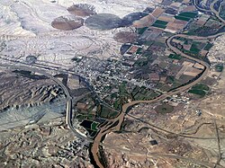
The city is located on the banks of the Green River, a major tributary of the Colorado River. The San Rafael Swell region is located west of the city, while Canyonlands National Park lies to the south. Today located exclusively in Emery County, the city was split between Emery and Grand counties until January 6, 2003, when Emery County's boundaries were expanded to follow the city limits. [6]

According to the United States Census Bureau, the city of Green River has a land area of 27.14 square miles (70,287,692 m2), and a water area 0.12 square miles (319,726 m2). [7]

Interstate 70 passes just south of the city, with access from Exits 160 and 164. Grand Junction, Colorado 102 miles (164 km) and Denver 343 miles (552 km) lie to the east. Cove Fort, I-70's western terminus, is 162 miles (261 km) to the west with Las Vegas 406 miles (653 km) via Interstate 15 from Cove Fort. Price lies 64 miles (103 km) to the northwest on US Routes 6 and 191 as well as Salt Lake City 168 miles (270 km) via Interstate 15 from Spanish Fork.

Climate

Green River has a moderate desert climate (Köppen BWk).

Climate data for Green River Municipal Airport, UT
MonthJanFebMarAprMayJunJulAugSepOctNovDecYear
Record high °F (°C)65
(18)
71
(22)
84
(29)
93
(34)
102
(39)
108
(42)
113
(45)
110
(43)
102
(39)
92
(33)
75
(24)
68
(20)
113
(45)
Mean daily maximum °F (°C)41.1
(5.1)
50.5
(10.3)
62.9
(17.2)
72.0
(22.2)
82.2
(27.9)
93.0
(33.9)
98.5
(36.9)
94.9
(34.9)
86.0
(30.0)
71.3
(21.8)
55.6
(13.1)
43.5
(6.4)
71.0
(21.7)
Daily mean °F (°C)27.4
(−2.6)
35.9
(2.2)
46.6
(8.1)
55.1
(12.8)
64.5
(18.1)
74.1
(23.4)
79.9
(26.6)
77.5
(25.3)
67.5
(19.7)
54.1
(12.3)
40.1
(4.5)
30.0
(−1.1)
54.4
(12.4)
Mean daily minimum °F (°C)13.7
(−10.2)
21.3
(−5.9)
30.3
(−0.9)
38.2
(3.4)
46.8
(8.2)
55.1
(12.8)
61.3
(16.3)
60.0
(15.6)
49.0
(9.4)
36.9
(2.7)
24.6
(−4.1)
16.5
(−8.6)
37.8
(3.2)
Record low °F (°C)−25
(−32)
−22
(−30)
6
(−14)
15
(−9)
23
(−5)
33
(1)
40
(4)
37
(3)
25
(−4)
12
(−11)
−6
(−21)
−16
(−27)
−25
(−32)
Average precipitation inches (mm)0.49
(12)
0.59
(15)
0.71
(18)
0.59
(15)
0.56
(14)
0.38
(9.7)
0.80
(20)
0.78
(20)
0.84
(21)
0.98
(25)
0.45
(11)
0.43
(11)
7.60
(193)
Average snowfall inches (cm)3.4
(8.6)
0.6
(1.5)
0.8
(2.0)
0
(0)
0
(0)
0
(0)
0
(0)
0
(0)
0
(0)
0
(0)
0.3
(0.76)
2.5
(6.4)
7.6
(19)
Source: [8]

Demographics

Historical population
CensusPop.Note
1890 375
1900 222−40.8%
1910 628182.9%
1920 6452.7%
1930 474−26.5%
1940 470−0.8%
1950 58324.0%
1960 1,07584.4%
1970 1,033−3.9%
1980 1,0481.5%
1990 866−17.4%
2000 97312.4%
2010 952−2.2%
2020 847−11.0%
U.S. Decennial Census [9]

As of the census [2] of 2020, there were 847 people and 330 households residing in the city. The population density was 34.45 people per square mile (13.30/km2). There were 397 housing units at an average density of 14.5 per square mile (5.6/km2). The racial makeup of the city was 70.2% White, 0% African American, 0.2% Native American, 0.5% Asian, 0% Pacific Islander, 11.6% from other races, and 17.2% from two or more races. Hispanic or Latino of any race were 33% of the population.

There were 330 households, out of which 60.9% were married couples living together, 16.1% had a female householder with no spouse present, and 18.2% had a male householder with no spouse present. The average household size was 2.77.

In the city the population was spread out, with 24.1% under 18, 9.8% from 18 to 24, 26.2% from 25 to 44, 17.2% from 45 to 64, and 13.6% who were 65 years of age or older. The median age was 32.8 years.

The median income for a household in the city was $42,361. About 21.1% of the population were below the poverty line.

Economy

Located approximately 100 miles (160 km) from both Richfield, Utah, and Grand Junction, Colorado, Green River's local economy primarily caters to serving passers-by on Interstate 70, since there are no services on I-70 westbound between Green River and Salina, 107 miles (172 km) away. The economy relies heavily on hotels, fast food, and a few other restaurants and gas stations. A large natural gas field has been discovered 3 miles (5 km) south of the city. The field is operated by Delta Petroleum, headquartered in Denver, Colorado.

Green River is famous for its melons, sold during the growing season, and has an annual Melon Days Festival. [10] It is also a popular freeride mountain biking spot.

A proposed nuclear power plant, the Blue Castle Project, is located approximately five miles west-northwest of the town. [11]

Infrastructure

Transportation

Amtrak #5 pulling into Green River Amtrak Green River.jpg
Amtrak #5 pulling into Green River

Amtrak, the national passenger rail system, provides service to Green River station, operating its California Zephyr daily in both directions between Chicago and Emeryville, California.

Interstate 70, along with U.S. 6, U.S. 191, and U.S. 50, also passes through Green River, the first eastbound services after Salina and the final westbound services, because the two cities are 110 miles (180 km) apart, the longest stretch of the interstate with no services in the United States.

The Main road in Green River is a short State road, SR 19, with Business I-70.

Notable people

The town becomes the new home of the Mousekewitz-family in An American Tail: Fievel Goes West as well as the main location in the subsequent television series Fievel's American Tails .

Two chapters of Stephen King's novel The Stand are set in a post-apocalyptic Green River.

Green River is the home of three of the characters in Edward Abbey's novel, The Monkey Wrench Gang . [12]

See also

Related Research Articles

<span class="mw-page-title-main">Emery County, Utah</span> County in Utah, United States

Emery County is a county in east-central Utah, United States. As of the 2020 United States Census, the population was 9,825. Its county seat is Castle Dale, and the largest city is Huntington.

<span class="mw-page-title-main">Grand County, Utah</span> County in Utah, United States

Grand County is a county on the east central edge of the U.S. state of Utah, United States. As of the 2020 United States Census, the population was 9,669. Its county seat and largest city is Moab.

<span class="mw-page-title-main">Moffat County, Colorado</span> County in Colorado, United States

Moffat County is a county located in the U.S. state of Colorado. As of the 2020 census, the population was 13,292. The county seat is Craig. With an area of 4,751 square miles, it is the second-largest county by area in Colorado, behind Las Animas County.

<span class="mw-page-title-main">Larimer County, Colorado</span> County in Colorado, United States

Larimer County is a county located in the U.S. state of Colorado. As of the 2020 census, the population was 359,066. The county seat and most populous city is Fort Collins. The county was named for William Larimer, Jr., the founder of Denver.

<span class="mw-page-title-main">Avon, Colorado</span> Town in Colorado, United States

Avon is a home rule municipality located in Eagle County, Colorado, United States. The town population was 6,072 at the 2020 United States Census. The town is a part of the Edwards, CO Micropolitan Statistical Area. Avon is the gateway to the Beaver Creek Resort which lies about two miles (3 km) south of the town. It was the previous site of Vail Resorts before the company moved its physical headquarters to Broomfield, Colorado, in 2006. The town is the home of Liberty Skis, an independent ski manufacturing company.

<span class="mw-page-title-main">Eagle, Colorado</span> Town in Colorado, United States

Eagle is the Statutory Town that is the county seat of Eagle County, Colorado, United States. The town population was 7,511 at the 2020 United States Census, a +15.41% increase since the 2010 United States Census. Eagle is the part of the Edwards, CO Micropolitan Statistical Area.

<span class="mw-page-title-main">Minturn, Colorado</span> Town in Colorado, United States

Minturn is a home rule municipality in Eagle County, Colorado, United States. The town population was 1,033 at the 2020 United States Census.

<span class="mw-page-title-main">Rifle, Colorado</span> City in Colorado, United States

Rifle is a home rule municipality in, and the most populous community of, Garfield County, Colorado, United States. The population was 10,437 at the 2020 census. Rifle is a regional center of the cattle ranching industry located along Interstate 70 and the Colorado River just east of the Roan Plateau, which dominates the western skyline of the town. The town was founded in 1882 by Abram Maxfield, and was incorporated in 1905 along Rifle Creek, near its mouth on the Colorado. The community takes its name from the creek.

<span class="mw-page-title-main">Limon, Colorado</span> Town in Colorado, United States

Limon is a statutory town that is the most populous municipality in Lincoln County, Colorado, United States. The population was 2,043 at the 2020 United States Census. Limon lies at the intersection of Interstate 70, U.S. Highways 24, 40, 287, and Colorado Highway 71. The Limon Correctional Facility is part of the Colorado Department of Corrections system and is a major employer in the area with employment of roughly 350.

<span class="mw-page-title-main">Sterling, Colorado</span> City in Colorado, United States

Sterling is a home rule municipality and the county seat and most populous municipality of Logan County, Colorado, United States. Sterling is the principal city of the Sterling, CO Micropolitan Statistical Area. The city population was 13,735 at the 2020 census.

<span class="mw-page-title-main">Helper, Utah</span> City in Utah, United States

Helper is a city in Carbon County, Utah, United States, approximately 110 miles (180 km) southeast of Salt Lake City and 7 miles (11 km) northwest of the city of Price. The population was 2,201 at the 2010 census.

<span class="mw-page-title-main">Price, Utah</span> City in Utah, United States

Price is a city in the U.S. state of Utah and the county seat of Carbon County. The city is home to Utah State University Eastern, as well as the USU Eastern Prehistoric Museum. Price is located within short distances of both Nine Mile Canyon and the Manti-La Sal National Forest.

<span class="mw-page-title-main">Castle Dale, Utah</span> City in Utah, United States

Castle Dale is a city in northwestern Emery County, Utah, United States. The population was 1,492 at the 2020 census. It is the county seat of Emery County.

<span class="mw-page-title-main">Emery, Utah</span> Town in Utah, United States

Emery is a town in Emery County, Utah, United States. The population was 288 at the 2010 census.

<span class="mw-page-title-main">Moab, Utah</span> City in Utah, United States of America

Moab is the largest city and county seat of Grand County in eastern Utah in the western United States, known for its dramatic scenery. The population was 5,366 at the 2020 census. Moab attracts many tourists annually, mostly visitors to the nearby Arches and Canyonlands National Parks. The town is a popular base for mountain bikers who ride the extensive network of trails including the Slickrock Trail, and for off-roaders who come for the annual Moab Jeep Safari.

<span class="mw-page-title-main">Cedar City, Utah</span> City in the United States

Cedar City is the largest city in Iron County, Utah, United States. Located 250 miles (400 km) south of Salt Lake City, it is 170 miles (270 km) north of Las Vegas on Interstate 15. Southern Utah University is located in Cedar City. It is the home of the Utah Shakespeare Festival, the Utah Summer Games, the Simon Fest Theatre Co., and other events. As of the 2020 census the city had a population of 35,235, up from 28,857 in the 2010 census.

<span class="mw-page-title-main">Richfield, Utah</span> City in the United States

Richfield is a city in and the county seat of Sevier County, Utah, United States, and is the largest city in southern-central Utah.

<span class="mw-page-title-main">Thompson Springs, Utah</span> Census-designated place in Utah, United States

Thompson Springs, also officially known for a time as just Thompson, is a small census-designated place in central Grand County, Utah, United States. The population was 39 at the 2010 census. The town is just north of the east–west highway route shared by Interstate 70, U.S. Route 6 and U.S. Route 50, between Crescent Junction and Cisco. Moab, the county seat, is 37 miles (60 km) to the south. Thompson Springs is located in high desert country at an elevation of 5,246 feet (1,599 m), with the Book Cliffs just to the north. The town's ZIP code is 84540. The mystery "The Silver Spur Cafe" by Chinle Miller is partially set in Thompson Springs.

<span class="mw-page-title-main">Interstate 70 in Utah</span> Section of Interstate highway in Utah

Interstate 70 (I-70) is a mainline route of the Interstate Highway System in the United States connecting Utah and Maryland. The Utah section runs east–west for approximately 232 miles (373 km) across the central part of the state. Richfield is the largest Utah city served by the freeway, which does not serve or connect any urban areas in the state. The freeway was built as part of a system of highways connecting Los Angeles and the Northeastern United States. I-70 was the second attempt to connect southern California to the east coast of the United States via central Utah, the first being a failed attempt to construct a transcontinental railroad. Parts of that effort were reused in the laying out of the route of I-70.

<span class="mw-page-title-main">Dinosaur Diamond</span> Scenic road in Utah and Colorado in the United States

The Dinosaur Diamond is a 486-mile (782 km) scenic and historic byway loop through the dinosaur fossil laden Uinta Basin of the U.S. states of Utah and Colorado. The byway comprises the following two National Scenic Byways:

References

  1. "2019 U.S. Gazetteer Files". United States Census Bureau. Retrieved August 7, 2020.
  2. 1 2 "U.S. Census website". United States Census Bureau . Retrieved January 31, 2008.
  3. "US Board on Geographic Names". United States Geological Survey. October 25, 2007. Retrieved January 31, 2008.
  4. "Green River city, Utah - Census Bureau Profile". U.S. Census Bureau. Retrieved October 5, 2022.
  5. "History of Green River". Official Website for Green River, Utah. City of Green River, Utah. Archived from the original on October 8, 2009. Retrieved December 11, 2009.
  6. Geographic Change Notes: Utah Archived 2008-05-02 at the Wayback Machine , United States Census Bureau, 2007. Accessed 2009-03-04.
  7. Bureau, US Census. "Gazetteer Files". Census.gov. Retrieved October 5, 2022.
  8. "Monthly Climate Normals (1981–2010) – Green River Aviation, UT". NOAA Regional Climate Centers. Retrieved June 27, 2020.
  9. "Census of Population and Housing". Census.gov. Retrieved June 4, 2015.
  10. "Melon Days".
  11. Stoddard, Patsy (January 24, 2017). "Update on the Nuclear Power Plant for Green River". Castle Dale, Utah: Emery County Progress. Archived from the original on February 11, 2017. Retrieved February 9, 2017.
  12. Erisman, Fred (1979). "A Variant Text of the Monkey Wrench Gang". Western American Literature. 14 (3): 227–228. doi:10.1353/wal.1979.0095. S2CID   165877705 . Retrieved July 5, 2023.

Further reading