Grafton is a ghost town, just south of Zion National Park in Washington County, Utah, United States. Said to be the most photographed ghost town in the West, it has been featured as a location in several films, including 1929's In Old Arizona—the first talkie filmed outdoors—and the classic Butch Cassidy and the Sundance Kid. The nearest inhabited town is Rockville.
Ajax is a ghost town located in the Rush Valley area of southeastern Tooele County, Utah, United States. The town grew up around a unique department store started in 1869 by a Welsh immigrant named William Ajax. He operated the Ajax Underground Store until his death in 1899, and the settlement came to an end as the other residents left by 1900. All that remains today is a hole in the ground, with a historical marker standing nearby.
Mosida is a ghost town located on the southwestern shore of Utah Lake, in Utah County, Utah, United States. The nearest inhabited town is Elberta, some 12 miles (19 km) to the south. A heavily promoted planned community in the 1910s, Mosida was ultimately a failure.
Kiz is a ghost town located in arid Clark Valley, in the sparsely populated eastern part of Carbon County, Utah, United States. This agricultural settlement existed between approximately 1906 and 1940. The nearest currently inhabited town is East Carbon.
Dover is a ghost town located in Sanpete County, Utah, United States. The site lies west of Fayette across the Sevier River.
Mohrland is a ghost town located in Emery County, Utah, United States. Lying in Cedar Creek Canyon near the Carbon County line, Mohrland was Emery County's largest coal mining town, with a history more typical of Carbon County's coal camps than of most Emery County communities.

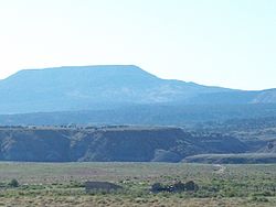
Paria or Pahreah, is a ghost town on the Paria River in Grand Staircase–Escalante National Monument in central Kane County, Utah, United States. It was inhabited from 1870 to 1929, and later used as a filming location.

Widtsoe is an unincorporated community and a near-ghost town in Garfield County, Utah, United States. Located in John's Valley northeast of Bryce Canyon and along the Sevier River at the mouth of Sweetwater Creek, the town existed from about 1908 to 1936.
Castleton is a ghost town in the Castle Valley in southeastern Grand County, Utah, United States.
Argyle is a ghost town located in Rich County, Utah, United States. Lying some 3 miles (4.8 km) southwest of Randolph on Big Creek, it was inhabited from approximately 1875–1915.

Giles is a ghost town located along the Fremont River in the Blue Valley of Wayne County, Utah, United States. The town was inhabited circa 1883–1919.
Hebron is a ghost town on Shoal Creek in Washington County in southwestern Utah, United States. Hebron was inhabited from 1862 until 1902, when the already-declining town was mostly destroyed by an earthquake. The present-day city of Enterprise, 6 miles (9.7 km) to the east, was settled largely by people leaving Hebron.

Duncan's Retreat is a ghost town located just off Utah State Route 9 in the eastern part of Washington County, in southwestern Utah, United States. Lying some 3 miles (4.8 km) east of Virgin and just southwest of Zion National Park, Duncan's Retreat was inhabited about 1861–1895.
Knightsville is a ghost town located in the East Tintic Mountains on the northern slope of Godiva Mountain, approximately 2 miles (3.2 km) east of Eureka, in the northeastern corner of Juab County in central Utah, United States. A silver mining camp, Knightsville was established and operated as a company town by local mining entrepreneur Jesse Knight. The town was inhabited from 1896 until approximately 1940.
McCornick is an unincorporated community and near-ghost town located in Millard County, Utah, United States. Lying in Whiskey Creek Flat 11 miles (18 km) northwest of Holden, McCornick was a failed land development project that lasted from 1919 until circa 1930. Today, McCornick is made up of a few scattered homes and farms.
Russian Settlement is a ghost town in the Park Valley area of Box Elder County, Utah, United States. It is not known what name, if any, the settlers from Russia gave to their community; it has been called "Box Elder County's ghost town with no name." The settlement, which lasted from about 1914–1917, was formed by a group of Molokan Spiritual Christians from Russia of mixed faiths and ethnicities. The colony failed quickly because the company who sold them the land exaggerated its quality and never provided promised facilities to make the land livable. The most noticeable remnant of Russian Settlement is a cemetery with two graves.
Coal City is a ghost town in Carbon County, Utah, United States. Established in 1885, Coal City was initially a farming community until coal was discovered in the area. Small-scale mining began to take place, and because the mining operations were a mile or two away from the mines at National and Consumers, it was assumed that the citizens of the town would lack workplace stress. Coal production began to decline in 1935, and the town was essentially abandoned with just two residences occupied by the late 1960s.
Cedar Creek is a ghost town in Box Elder County, Utah, United States. Founded in the 1860s, Cedar Creek was a farming town. Businesses included a school, an inn, and a store. The interstate highway system built through Cedar Creek and the nearby communities of Snowville and Park Valley. Cedar Creek was abandoned when weather conditions made farming difficult.
Desert Lake is a ghost town in Castle Valley in northern Emery County, Utah, United States. It was inhabited from 1885 to about 1910.