Grand Canyon Skywalk

Last updated
Grand Canyon Skywalk
SkywalkFromOutsideLedge.jpg
Skywalk from Outside Ledge
Coordinates 36°0′44″N113°48′40″W / 36.01222°N 113.81111°W / 36.01222; -113.81111
CarriesPedestrian
Locale Grand Canyon West, Arizona, US
Official nameGrand Canyon Skywalk
Owner Hualapai Tribe
Characteristics
DesignCurved pedestrian cantilever bridge
MaterialSteel, glass
Total length70 feet (21 m)
Width10 feet 2 inches (3.10 m)
History
ArchitectMark Ross Johnson
OpenedMarch 28, 2007
Location
Grand Canyon Skywalk

The Grand Canyon Skywalk is a horseshoe-shaped cantilever bridge with a glass walkway at Eagle Point in Arizona near the Colorado River, on the edge of a side canyon in the Grand Canyon West area of the main canyon. [1] It opened as a tourist attraction in 2007, located outside the boundaries of the Grand Canyon National Park.

Contents

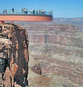
USGS topographic maps indicate the Skywalk's elevation as 4,770 ft (1,450 m) above sea level. The elevation of the Colorado River at the base of the canyon below is 1,160 ft (350 m). The vertical drop directly below the skywalk is 500 to 800 feet (150 to 240 m). [2] The attraction is immediately north of Grand Canyon West Airport and about 75 miles (121 km) east of Las Vegas, Nevada, although nearly 130 miles (210 km) by car. The nearest city with a population greater than 10,000 people is Kingman, Arizona, about 50 miles (80 km) south.

Commissioned and owned by the Hualapai Indian tribe, the skywalk was unveiled March 20, 2007, and opened to the general public on March 28, 2007. The attraction's operators have reported over one million visitors per year several times, first occurring in 2015. [3]

Design and construction

Aerial view of the Grand Canyon Skywalk Grand Canyon Skywalk - aerial.jpg
Aerial view of the Grand Canyon Skywalk

David Jin, an entrepreneur who had been involved with tourism and the Hualapai Nation for some time, had the idea of extending a platform out over the edge of the Grand Canyon. With the help of architect Mark Ross Johnson, that idea evolved into a rectangular walkway and eventually the U-shaped walkway constructed. Executive Construction Management, Las Vegas, NV., was the general contractor for the project, Company Owner and Project Manager, Scott Klempke.

The overall Skywalk width is 65 feet (20 m). The Skywalk length extending out from the post supports closest to the canyon wall is 70 feet (21 m). The outer and inner 32-inch-wide (810 mm) by 72-inch-deep (1,800 mm) bridge box beams are supported by eight 32-by-32-inch (810 mm × 810 mm) box posts having four posts on each side of the visitor's center, once completed. The eight posts are anchored in pairs into four large concrete footings that are in turn anchored to the bedrock by ninety-six 2+12-inch-diameter (64 mm) high strength steel threaded rod rock anchors grouted 46 feet (14 m) deep into the rock.

The deck of the Skywalk has been made with four layers of Saint-Gobain Diamant low-iron glass with DuPont SentryGlas interlayer. Deck width is 10 feet 2 inches (3.10 m). The Skywalk glass sidings were made with the same glass as the deck, but fewer layers (two) bent to follow the walkway's curvature. The glass sidings are 5 feet 2 inches (1.57 m) tall and have been designed for high wind pressures.

The Skywalk deck was designed for a 100-pound-per-square-foot (490 kg/m2) live load along with code-required seismic and wind forces. The foundation can withstand an 8.0 magnitude earthquake within 50 miles (80 km). [4] Fine-tuning of the project occurred after a wind loading and pedestrian induced vibration analysis. Two tuned mass dampers were installed inside the outer box beam as well as one inside the inner box beam at the furthest extension of the Skywalk to reduce pedestrian footfall vibration. The walkway could carry 822 people that weigh 200 pounds (91 kg) each without overstress, but maximum occupancy at one time is 120 people.

Closer view of the entrance building to skywalk Skywalk, Arizona, USA (9536805526).jpg
Closer view of the entrance building to skywalk

The Skywalk was assembled on top of the canyon wall in line with its final placement and moved into final position by a jack and roll rig. The Skywalk infrastructure itself weighs a little over 1,000,000 pounds (450,000 kg) without counterweights but including the tuned mass dampers, railing hardware, glass rails, glass deck and steel box beams. At the time of roll-out, the Skywalk weighed approximately 1.6 million pounds (730,000 kg). The process was completed in two days.

Astronauts Buzz Aldrin and John Herrington attended the opening ceremony on March 20, 2007.

A National Geographic documentary film on the construction of the Skywalk has been published. [5]

Cornerstone of a larger plan

Aerial view: Grand Canyon West Airport at left center. Grand Canyon National Park lands (top), north of the Colorado River. Grand Canyon West Airport.jpg
Aerial view: Grand Canyon West Airport at left center. Grand Canyon National Park lands (top), north of the Colorado River.

According to Hualapai officials, the cost of the Skywalk was $30 million. [6] Plans for the Grand Canyon Skywalk complex include a museum, movie theater, VIP lounge, gift shop, and several restaurants including a high-end restaurant called The Skywalk Café where visitors will be able to dine outdoors at the canyon's rim. The Skywalk is the cornerstone of a larger plan by the Hualapai tribe, which it hopes will be the catalyst for a 9,000-acre (36 km2) development to be called Grand Canyon West; it would open up a 100-mile (160 km) stretch along the canyon's South Rim and include hotels, restaurants, a golf course, casinos, and a cable car to ferry visitors from the canyon rim to the Colorado River, which has been previously inaccessible. [6]

Controversy

Hualapai

Opponents within the tribe view the project as disturbing sacred ground. [7] Supporters within the tribe counter that it is an opportunity to generate much-needed cash to combat serious problems that plague the small 2,000-resident reservation, including a 50% unemployment rate, widespread alcoholism, and poverty. [6] Other tribal members are happy with the Skywalk, but they have expressed concern over future development. They are also concerned about the potential lack of sustainability because the water used in the development is not taken from the Colorado River but trucked in from elsewhere. [6] [8] Effective February 7, 2012, certain members of the Hualapai Tribal Council, without prior notice, seized control of the Skywalk which was built and previously run by Grand Canyon Skywalk Development (GCSD), a Las Vegas, Nevada, corporation. GCSD is no longer in charge of daily operations at the Skywalk. [9] GCSD was awarded $28 million in damages by an arbitration board, which was upheld in U.S. District Court in February 2013. [10]

View of the Skywalk and the surrounding canyon Grandcanyon skywalk hd.jpg
View of the Skywalk and the surrounding canyon
Grand Canyon regional map NPS grand-canyon-regional-map.jpg
Grand Canyon regional map

Environmentalists

People outside of the tribe, including Arizona environmental groups and former National Park Service officials, have expressed concern about the project's obtrusiveness in the natural environment, considering it a defacement of a national treasure. Former Grand Canyon National Park superintendent Robert Arnberger has described the development as "the equivalent of an upscale carnival ride," adding that he has been unable to resolve "the apparent conflict between the tribe's oft-stated claim that there is no better caregiver and steward of the Grand Canyon than the tribe, and their approach to the land – which is based on heavy use and economics." [6] Tribal leaders counter that the five million people a year who visit the National Park portion are already overburdening an area and, further, that the tribe needs financial income. [11] As of 2013, the Skywalk attracted approximately 370,000 visitors per year. [12] In 2015, the attraction drew a million visitors in a year for the first time. [13]

Tourism, access, and protection

Access to the Skywalk can be made from Las Vegas, Nevada, in the north or Kingman, Arizona, in the south, via Highway 93. The routes converge (at CR 7/Buck and Doe Rd) near Diamond Bar Road.

There are several packages available for purchase at the airport terminal visitor center. Every package includes parking at the terminal and shuttle bus transportation to the two scenic viewing areas and the Hualapai Ranch. As of 2015, the final 9 miles (14 km) of county-maintained road to the attraction has been paved [14] and is now accessible to everyone. [4] In addition to admission, visitors may purchase professional photographs of their visit to the Skywalk in the gift shop, as personal cameras are not allowed on the Skywalk itself. Along with other personal property, cameras must be stored in a locker before entering the Skywalk. [15] Besides the Skywalk, the Eagle Point offers other activities including Native American dances in the amphitheater, Native American gift shop, and Native American Village with dwellings of the indigenous tribes of the region, such as Hualapai, Plains, Hopi, Navajo, and Havasupai. [16] There are buses connecting all the points within the Grand Canyon West area. [17]

Related Research Articles

<span class="mw-page-title-main">Grand Canyon</span> Steep-sided canyon carved by the Colorado River in Arizona, United States

The Grand Canyon is a steep-sided canyon carved by the Colorado River in Arizona, United States. The Grand Canyon is 277 miles (446 km) long, up to 18 miles (29 km) wide and attains a depth of over a mile.

<span class="mw-page-title-main">Supai, Arizona</span> CDP in Coconino County, Arizona

Supai is a census-designated place (CDP) in Coconino County, Arizona, United States, within the Grand Canyon.

<span class="mw-page-title-main">Peach Springs, Arizona</span> CDP in Mohave County, Arizona

Peach Springs is a census-designated place (CDP) in Mohave County, Arizona, United States. The population was 1,098 at the 2020 census. Peach Springs serves as the administrative headquarters of the Hualapai people and is located on the Hualapai Reservation.

<span class="mw-page-title-main">Hyatt Regency walkway collapse</span> 1981 structural collapse in Kansas City, Missouri

On July 17, 1981, the Hyatt Regency Hotel in Kansas City, Missouri, suffered the structural collapse of two overhead walkways. Loaded with partygoers, the concrete and glass platforms cascaded down, crashing onto a tea dance in the lobby, killing 114 and injuring 216. Kansas City society was affected for years, with the collapse resulting in billions of dollars of insurance claims, legal investigations and city government reforms.

<span class="mw-page-title-main">Havasupai</span> Indigenous ethnic group of Arizona, US

The Havasupai people are an Native American people and tribe who have lived in the Grand Canyon for at least the past 800 years. Havasu means "blue-green water" and pai "people".

<span class="mw-page-title-main">Hualapai</span> Native American tribe

The Hualapai is a federally recognized Native American tribe in Arizona with about 2300 enrolled members. Approximately 1353 enrolled members reside on the Hualapai Reservation, which spans over three counties in Northern Arizona.

<span class="mw-page-title-main">Mike O'Callaghan–Pat Tillman Memorial Bridge</span> Arch bridge over the Colorado River near Hoover Dam

The Mike O'Callaghan–Pat Tillman Memorial Bridge is an arch bridge in the United States that spans the Colorado River between the states of Arizona and Nevada. The bridge is located within the Lake Mead National Recreation Area approximately 30 miles (48 km) southeast of Las Vegas, and carries Interstate 11 and U.S. Route 93 over the Colorado River. Opened in 2010, it was the key component of the Hoover Dam Bypass project, which rerouted US 93 from its previous routing along the top of Hoover Dam and removed several hairpin turns and blind curves from the route. It is jointly named for Mike O'Callaghan, Governor of Nevada from 1971 to 1979, and Pat Tillman, an American football player who left his career with the Arizona Cardinals to enlist in the United States Army and was killed in Afghanistan in 2004 by friendly fire.

<span class="mw-page-title-main">Havasu Falls</span> Waterfall in the Grand Canyon in Arizona

Havasu Falls is a waterfall of Havasu Creek, located in the Grand Canyon, Arizona, United States. It is within Havasupai tribal lands.

<span class="mw-page-title-main">Bixby Bridge</span> Highway bridge on the Big Sur Coast of California

Bixby Bridge, also known as Bixby Creek Bridge, on the Big Sur coast of California, is one of the most photographed bridges in California due to its aesthetic design, "graceful architecture and magnificent setting". It is a reinforced concrete open-spandrel arch bridge. The bridge is 120 miles (190 km) south of San Francisco and 13 miles (21 km) south of Carmel in Monterey County on State Route 1.

<span class="mw-page-title-main">Glass floor</span> Flooring composed of transparent or translucent glass

Glass floors are made with transparent glass when it is useful to view something from above or below; whereas translucent glass is used when there is no need to view through. In either case, toughened glass is usually chosen, for its durability and resistance to breakage.

<span class="mw-page-title-main">Havasupai Indian Reservation</span> Reservation

The Havasupai Indian Reservation is a Native American reservation for the Havasupai people, surrounded entirely by the Grand Canyon National Park, in Coconino County in Arizona, United States. It is considered one of America's most remote Indian reservations. The reservation is governed by a seven-member tribal council, led by a chairman who is elected from among the members of the council. The capital of the reservation is Supai, situated at the bottom of Cataract Canyon, one of the tributary canyons of the Grand Canyon. Havasupai is a combination of the words Havasu and pai, thus meaning "people of the blue-green waters".

<span class="mw-page-title-main">Grand Canyon West Airport</span> Airport in Mohave County, Arizona

Grand Canyon West Airport is a public airport 60 miles northwest of Peach Springs, in Mohave County, Arizona, United States. It is owned and operated by the Hualapai tribe and is on the Hualapai Indian Reservation.

<span class="mw-page-title-main">Adventuredome</span> Indoor amusement park at Circus Circus in Winchester, Nevada

Adventuredome is a 5-acre (2.0 ha) indoor amusement park at Circus Circus in Winchester, Nevada on the Las Vegas Strip. It is owned by Phil Ruffin. It is contained within a large glass dome, and offers various rides and attractions including the Canyon Blaster and El Loco roller coasters, a rock climbing wall, an 18-hole miniature golf course, a video game arcade, and carnival-type games. Because the park is enclosed, it is unaffected by weather, unlike most theme parks, and is open year-round. Every October from 2003 until 2017, the Adventuredome was turned into the Halloween-themed Fright Dome.

<span class="mw-page-title-main">Grand Canyon Caverns</span> Landform in Coconino County, Arizona

The Grand Canyon Caverns, located just a few miles east of Peach Springs, Arizona, lie 210 feet (64 m) below ground level. They are among the largest dry caverns in the United States. Dry caverns comprise only 3% of caverns in the world. Because of the lack of water, stalagmites and stalactites are rare in the caverns.

<span class="mw-page-title-main">Geography of Arizona</span>

Arizona is a landlocked state situated in the southwestern region of the United States of America. It has a vast and diverse geography famous for its deep canyons, high- and low-elevation deserts, numerous natural rock formations, and volcanic mountain ranges. Arizona shares land borders with Utah to the north, the Mexican state of Sonora to the south, New Mexico to the east, and Nevada to the northwest, as well as water borders with California and the Mexican state of Baja California to the southwest along the Colorado River. Arizona is also one of the Four Corners states and is diagonally adjacent to Colorado.

<span class="mw-page-title-main">Grand Canyon West, Arizona</span> Census-designated place in Arizona, United States

Grand Canyon West is a census-designated place (CDP) in Mohave County, Arizona, United States, located on the Hualapai Reservation. The population was reported as 0 at the 2020 census. Grand Canyon West is home to the tribe's Grand Canyon business operations, including the Grand Canyon West Airport and the Grand Canyon Skywalk. Typically, they are open from 8:00 a.m. – 6:00 p.m., including all holidays.

<span class="mw-page-title-main">Bat Cave mine</span> Former mining operation in Mohave County, Arizona

The Bat Cave mine was a bat guano mine in a natural cave located in the western Grand Canyon of Arizona at river mile 266, 800 feet (240 m) above Lake Mead.

Diamond Creek is an intermittent stream that flows through the Hualapai tribal reservation generally north from Peach Springs, Arizona to the Colorado River.

<i>Skywire Live</i> 2013 Disney Channel special

Skywire Live with Nik Wallenda is a Discovery Channel special that aired on June 23, 2013. The special was billed as a highwire walk across "the majestic Grand Canyon". Interpretations varied as to whether the actual location – the Little Colorado River Gorge in Navajo territory outside Grand Canyon National Park's borders – was truly part of the Grand Canyon.

<span class="mw-page-title-main">Antares, Arizona</span> Census-designated place in Arizona, United States

Antares is an unincorporated community and census designated place (CDP) in Mohave County, Arizona, United States. As of the 2020 census, it had a population of 132. It exists along part of historic U.S. Route 66.

References

  1. Yost, Mark. Close to the Edge, Wall Street Journal. 2007-04-10.
  2. Acme mapper: USGS topographic map
  3. "Grand Canyon Skywalk, Grand Canyon West Top 1 Million Visitors For 3rd Straight Year". prnewswire.com (Press release). Grand Canyon West. December 21, 2017. Retrieved June 18, 2023.
  4. 1 2 Bryant, Kathleen (2008). Grand Canyon (4th ed.). Berkeley, CA: Avalon Travel. pp.  150–151. ISBN   978-1-59880-146-0.
  5. NationalGeographic.com
  6. 1 2 3 4 5 Cart, Julie. "Grand Canyon Skywalk opens deep divide". Los Angeles Times. 2007-02-11.
  7. Grand Canyon glass Skywalk opens. BBC. 2007-03-20.
  8. Denniston, Wendy Yanagihara, Jennifer (2008). Grand Canyon National Park (2nd ed.). Footscray (Vic.): Lonely Planet. ISBN   978-1-74104-483-6.{{cite book}}: CS1 maint: multiple names: authors list (link)
  9. "Arizona tribe votes to take over management of Grand Canyon Skywalk". 7 February 2012.
  10. "Court upholds $28 million award in Grand Canyon Skywalk case".
  11. "Tourism on tribal land is a growing industry". Marketplace. July 3, 2017.
  12. Wagner, Dennis (19 February 2013). "Grand Canyon Skywalk judgment could devastate tribe". USA Today. Retrieved 6 September 2014. The Skywalk, about 130 miles northwest of Flagstaff, opened to international media coverage in 2007 and reportedly attracts about 370,000 visitors annually.
  13. "Grand Canyon West Tops 1 Million Visitor Mark In 2015; Tourism Soars At Grand Canyon Skywalk, Other Attractions". prnewswire.com (Press release). Grand Canyon Resort Corporation. December 22, 2015. Retrieved June 18, 2023.
  14. "Hualapai Tourism skywalk FAQ page". Archived from the original on 2013-06-07. Retrieved 2013-11-02.
  15. "Hualapai Tourism skywalk site\". Archived from the original on 2013-10-26. Retrieved 2013-11-02.
  16. "Grand Canyon Skywalk & Eagle Point" . Retrieved May 2, 2019.
  17. "Grand Canyon Skywalk" . Retrieved May 2, 2019.