The Snoqualmie River is a 45-mile (72 km) long river in King County and Snohomish County in the U.S. state of Washington. The river's three main tributaries are the North, Middle, and South Forks, which drain the west side of the Cascade Mountains near the town of North Bend and join near the town of Snoqualmie just above the Snoqualmie Falls. After the falls the river flows north through rich farmland and the towns of Fall City, Carnation, and Duvall before meeting the Skykomish River to form the Snohomish River near Monroe. The Snohomish River empties into Puget Sound at Everett. Other tributaries of the Snoqualmie River include the Taylor River and the Pratt River, both of which enter the Middle Fork, the Tolt River, which joins at Carnation, and the Raging River at Fall City.

The English River is a tributary of the Iowa River in southeastern Iowa in the United States. The main stem of the river is 37.4 miles (60.2 km) long. Including its longest headwaters tributary, the North English River, the total length increases to 89.2 miles (143.6 km). Via the Iowa River, it is part of the Mississippi River watershed. The Deep River is a minor tributary of the English River. The towns of North English, South English and Deep River are named for the English and Deep rivers.

Roaring Fork River is a tributary of the Colorado River, approximately 70 miles (110 km) long, in west central Colorado in the United States. The river drains a populated and economically vital area of the Colorado Western Slope called the Roaring Fork Valley or Roaring Fork Watershed, which includes the resort city of Aspen and the resorts of Aspen/Snowmass.

White River is a river, approximately 195 miles (314 km) long, in the U.S. states of Colorado and Utah and is a tributary of the Green River.

The Feather River is the principal tributary of the Sacramento River, in the Sacramento Valley of Northern California. The river's main stem is about 73 miles (117 km) long. Its length to its most distant headwater tributary is just over 210 miles (340 km). The main stem Feather River begins in Lake Oroville, where its four long tributary forks join together—the South Fork, Middle Fork, North Fork, and West Branch Feather Rivers. These and other tributaries drain part of the northern Sierra Nevada, and the extreme southern Cascades, as well as a small portion of the Sacramento Valley. The total drainage basin is about 6,200 square miles (16,000 km2), with approximately 3,604 square miles (9,330 km2) above Lake Oroville.

The Williams River is a tributary of the Gauley River, 33 miles (53 km) long, in east-central West Virginia, USA. Via the Gauley, Kanawha and Ohio Rivers, it is part of the watershed of the Mississippi River, draining an area of 132 square miles (342 km²) in a sparsely populated region of the southern Allegheny Mountains and the unglaciated portion of the Allegheny Plateau.

The Zumbro River is a tributary of the Mississippi River in the Driftless Area of southeastern Minnesota in the United States. It is 64.6 miles (104.0 km) long from the confluence of its principal tributaries and drains a watershed of 1,428 square miles (3,700 km2). The river's name in English is a change from its French name Rivière des Embarras due to its mouth located near Pine Island in the Mississippi River; the Dakota name for this river is Wapka Wazi Oju, having reference to the grove of great white pines at Pine Island.

The Nishnabotna River is a tributary of the Missouri River in southwestern Iowa, northwestern Missouri and southeastern Nebraska in the United States. It flows for most of its length as two parallel streams in Iowa, the East Nishnabotna River and the West Nishnabotna River. The east and west branches are each about 120 miles (190 km) long; from their confluence the Nishnabotna flows approximately another 16 miles (26 km).

The Rio Chama, a major tributary river of the Rio Grande, is located in the U.S. states of Colorado and New Mexico. The river is about 130 miles (210 km) long altogether. From its source to El Vado Dam its length is about 50 miles (80 km), from El Vado Dam to Abiquiu Dam is about 51 miles (82 km), and from Abiquiu Dam to its confluence with the Rio Grande is about 34 miles (55 km).
Mill Creek is a 5.3-mile-long (8.5 km) tributary stream of the North Fork South Branch Potomac River in Pendleton County, West Virginia. Mill Creek rises on the western flanks of North Fork Mountain and from there, flows north through Germany Valley. Its confluence with the North Fork lies at Hinkle Gap between Germany and Harman Knobs.

The Sol Duc River is a river in the U.S. state of Washington. About 78 miles (126 km) long, it flows west through the northwest part of the Olympic Peninsula, from the Olympic Mountains of Olympic National Park and Olympic National Forest, then through the broad Sol Duc Valley. Near the Pacific Ocean the Sol Duc River joins the Bogachiel River, forming the Quillayute River, which flows about 4 miles (6.4 km) to the Pacific Ocean at La Push. Although the Quillayute River is short, its large tributary rivers—the Sol Duc, Bogachiel, Calawah, and Dickey Rivers—drain the largest watershed of the northern Olympic Peninsula, 629 square miles (1,630 km2). The Sol Duc's watershed is the largest of the Quillayute's tributaries, at 219 square miles (570 km2).

Boulder Creek is a 31.4-mile-long (50.5 km) creek draining the Rocky Mountains to the west of Boulder, Colorado, as well as the city itself and surrounding plains.
The Little River is a 72-mile-long (116 km) tributary of the Savannah River in the U.S. state of Georgia. It is formed by the juncture of its North and South forks 5 miles (8 km) north of Crawfordville, and it flows generally east to Clark Hill Lake, where it joins the Savannah River 2 miles (3 km) north of the dam.

The Clearwater River is in the northwestern United States, in north central Idaho. Its length is 74.8 miles (120.4 km), it flows westward from the Bitterroot Mountains along the Idaho-Montana border, and joins the Snake River at Lewiston. In October 1805, the Lewis and Clark Expedition descended the Clearwater River in dugout canoes, putting in at "Canoe Camp," five miles (8 km) downstream from Orofino; they reached the Columbia Bar and the Pacific Ocean about six weeks later.

The Dickey River is a stream on the Olympic Peninsula in the U.S. state of Washington. It has three main forks, the East Fork, West Fork, and Middle Fork Dickey Rivers. The main stem is formed by the confluence of the East and West Forks. The river and its forks rise in the northwestern part of the Olympic Peninsula and flow generally south and west to join the Quillayute River near its mouth on the Pacific Ocean.

The Puerco River or Rio Puerco is a tributary of the Little Colorado River in northwestern New Mexico and northeastern Arizona. It flows through arid terrain, including the Painted Desert.
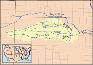
The North Fork Smoky Hill River is a river in the central Great Plains of North America. A tributary of the Smoky Hill River, it flows from eastern Colorado into western Kansas.
South Fork San Miguel River is a 6.5-mile-long (10.5 km) tributary of the San Miguel River in San Miguel County, Colorado. The river flows north from a confluence of the Lake Fork and the Howard Fork to a confluence with the San Miguel River west of Telluride.
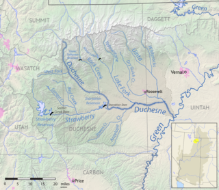
The Lake Fork River is a river in Duchesne County, Utah in the United States. It flows for 54 miles (87 km) from the Uinta Mountains, in a southeasterly direction, receiving the Yellowstone River above Mountain Home, to join the Duchesne River near Myton. The river is dammed near its headwaters to form Moon Lake, formerly a smaller natural lake.
The Yellowstone River is a river in Duchesne County, Utah in the United States. It flows south from the crest of the Uinta Mountains for 29 miles (47 km) to join the Lake Fork River about 5 miles (8.0 km) north of Mountain Home.