Blue Mesa Reservoir

Last updated
Blue Mesa Reservoir
Bluemesa.JPG
USA Colorado relief location map.svg
Red pog.svg
Blue Mesa Reservoir
Usa edcp relief location map.png
Red pog.svg
Blue Mesa Reservoir
Location Gunnison County, Colorado
Coordinates 38°28′13″N107°13′13″W / 38.4703°N 107.2204°W / 38.4703; -107.2204
Type reservoir
Primary inflows Gunnison River, Lake Fork Arm of the Gunnison River, Soap Creek, Cebolla Creek
Primary outflows Gunnison River
Basin  countriesUnited States
Max. length20 mi (32 km)
Surface area9,180 acres (3,720 ha)
Water volume940,800 acre-feet (1,160.5 GL)
Shore length196 mi (154 km)
Surface elevation7,519 ft (2,292 m)
1 Shore length is not a well-defined measure.

Blue Mesa Reservoir is an artificial reservoir located on the upper reaches of the Gunnison River in Gunnison County, Colorado. The largest lake located entirely within the state, Blue Mesa Reservoir was created by the construction of Blue Mesa Dam, a 390-foot tall earthen fill dam constructed on the Gunnison by the U.S. Bureau of Reclamation in 1966 for the generation of hydroelectric power. [1] Managed as part of the Curecanti National Recreation Area, a unit of the National Park Service, Blue Mesa Reservoir is the largest lake trout and Kokanee salmon fishery in Colorado. [2]

Contents

History

In 1956, the U.S. Bureau of Reclamation was given the responsibility, under the Colorado River Storage Project Act, to begin planning and construction of the Colorado River Storage Project (CRSP), a series of projects in Colorado, New Mexico, Utah, and Wyoming that would make possible comprehensive development of the waters of the Colorado River and its major tributaries. [3] One of the initial projects of the CRSP, the Curecanti Unit, focused on the upper reaches of the Gunnison River, the fifth-largest tributary of the Colorado River.

Blue Mesa Dam Bluemesadam.JPG
Blue Mesa Dam

The centerpiece of the plans for the Gunnison was the construction of four dams on a 40-mile stretch (64 km) of the river east of the National Park Service's Black Canyon of the Gunnison National Park, projects that would not only help control the amount of water flowing into the Colorado, but would also create new opportunities for flood control, water storage, and the generation of hydroelectric power. [4] The first of these dams was Blue Mesa Dam, which was begun in 1962 approximately 30 miles (48 km) west of Gunnison, and 1.5 miles (2.4 km) west of Sapinero. Finished four years later, the dam created Blue Mesa Reservoir, which became the primary water storage reservoir for the Curecanti Unit (later renamed the Wayne N. Aspinall Unit). [5]

Climate

According to the Köppen Climate Classification system, Blue Mesa Reservoir has a warm-summer humid continental climate, abbreviated "Dfb" on climate maps. The hottest temperature recorded here was 96 °F (36 °C) on July 22, 2005, while the coldest temperature recorded was −36 °F (−38 °C) on January 7, 1971. [6]

Climate data for Blue Mesa Lake, Colorado, 1991–2020 normals, extremes 1970–present
MonthJanFebMarAprMayJunJulAugSepOctNovDecYear
Record high °F (°C)56
(13)
54
(12)
69
(21)
79
(26)
87
(31)
94
(34)
96
(36)
93
(34)
89
(32)
81
(27)
67
(19)
55
(13)
96
(36)
Mean maximum °F (°C)41.1
(5.1)
45.6
(7.6)
59.4
(15.2)
70.7
(21.5)
79.3
(26.3)
86.9
(30.5)
90.8
(32.7)
88.4
(31.3)
83.4
(28.6)
75.1
(23.9)
60.5
(15.8)
45.5
(7.5)
91.2
(32.9)
Average high °F (°C)25.5
(−3.6)
30.5
(−0.8)
43.5
(6.4)
55.5
(13.1)
65.7
(18.7)
77.1
(25.1)
82.6
(28.1)
79.9
(26.6)
72.5
(22.5)
60.0
(15.6)
44.0
(6.7)
28.5
(−1.9)
55.4
(13.0)
Daily mean °F (°C)12.2
(−11.0)
16.9
(−8.4)
29.3
(−1.5)
39.8
(4.3)
48.8
(9.3)
58.0
(14.4)
64.4
(18.0)
62.6
(17.0)
54.7
(12.6)
43.4
(6.3)
29.8
(−1.2)
16.0
(−8.9)
39.7
(4.2)
Average low °F (°C)−1.2
(−18.4)
3.4
(−15.9)
15.1
(−9.4)
24.2
(−4.3)
31.9
(−0.1)
38.8
(3.8)
46.2
(7.9)
45.3
(7.4)
37.0
(2.8)
26.8
(−2.9)
15.5
(−9.2)
3.4
(−15.9)
23.9
(−4.5)
Mean minimum °F (°C)−18.1
(−27.8)
−13.2
(−25.1)
−1.4
(−18.6)
13.8
(−10.1)
22.4
(−5.3)
31.5
(−0.3)
38.6
(3.7)
38.0
(3.3)
26.9
(−2.8)
15.6
(−9.1)
1.7
(−16.8)
−12.7
(−24.8)
−20.1
(−28.9)
Record low °F (°C)−36
(−38)
−34
(−37)
−18
(−28)
5
(−15)
6
(−14)
22
(−6)
30
(−1)
26
(−3)
20
(−7)
3
(−16)
−14
(−26)
−25
(−32)
−36
(−38)
Average precipitation inches (mm)0.69
(18)
0.73
(19)
0.53
(13)
0.59
(15)
0.66
(17)
0.43
(11)
0.86
(22)
1.13
(29)
1.01
(26)
0.88
(22)
0.49
(12)
0.81
(21)
8.81
(225)
Average snowfall inches (cm)12.4
(31)
10.5
(27)
6.1
(15)
2.9
(7.4)
0.4
(1.0)
0.0
(0.0)
0.0
(0.0)
0.0
(0.0)
0.0
(0.0)
1.1
(2.8)
4.3
(11)
11.9
(30)
49.6
(125.2)
Average precipitation days (≥ 0.01 in)7.36.74.05.05.13.87.48.56.95.25.26.871.9
Average snowy days (≥ 0.1 in)6.76.23.21.90.20.00.00.00.00.73.16.228.2
Source 1: NOAA [7]
Source 2: National Weather Service [6]

Location and access

Blue Mesa Dam is located on the Gunnison river approximately 30 miles west of the city of Gunnison, near the intersection of U.S. 50 with Colorado Highway 92, which travels along the top of the dam. The reservoir extends east 20 miles and is composed of three main basins, the Iola, the Cebolla and the Sapinero, from east to west. U.S. 50 traverses the northern shore of both the Iola and Cebolla Basins before crossing the reservoir south on the Middle Bridge and continuing west to the dam.

The Middle Bridge crossing Blue Mesa Reservoir near Sapinero. Middlebridge.JPG
The Middle Bridge crossing Blue Mesa Reservoir near Sapinero.

The southern shore of the Iola Basin can be reached via Colorado Highway 149, which begins at an intersection with U.S. 50 at the Lake City Bridge, approximately 7 miles west of the city of Gunnison. While most of the recreational areas at Blue Mesa can be accessed from U.S. 50, the reservoir also contains a small number of facilities on the lake's deep arms, such as Cebolla Creek and Soap Creek, which can only be reached by boat or unpaved road.

Recreation activities

While it was the Bureau of Reclamation that conceived of the plan to impound the Gunnison and constructed the Blue Mesa Dam, it was the National Park Service that was tasked with developing and managing recreational facilities at Blue Mesa Reservoir and the two smaller lakes to the west. As a unit of the Curecanti National Recreation Area Blue Mesa Reservoir offers a number of recreational opportunities, including boating, fishing, boat-in, developed, and primitive camping, hiking, horseback riding, and hunting. A popular lake for boating, Blue Mesa has marinas at Elk Creek and Lake Fork, near the dam, both of which can be accessed by U.S. 50. Watercraft can also be launched from the Ponderosa and Stevens Creek campgrounds, and at Iola, on the reservoir's southern shore. During winter months Iola Basin is also a popular spot for ice fishing. [8]

The Dillon Pinnacles, Blue Mesa Reservoir Dillonpin.JPG
The Dillon Pinnacles, Blue Mesa Reservoir

Blue Mesa contains 8 developed campgrounds, two of which are designated for groups. These range from the 160-site Elk Creek on the main body of the lake to smaller, more remote sites like Ponderosa and Gateview located on arms of the lake. Several of the campsites can accommodate RV's, but only Elk Creek offers electrical hook-ups. [9] Boaters may camp overnight in 4 free camping areas with a total of 9 individual sites. Boaters may also camp on the southern shore of the Cebolla and Iola Basins, as long as campsites are not within a half-mile of any developed area, bridge, maintained public road or other boat-in/backcountry campsite. [10]

In 2022, decreases in Blue Mesa's already low water level caused by drought and the need to release water to aid Lake Powell downriver led to the first cancellation of boating season as announced on May 1, 2022. Federal and state water managers indicated in early May, 2022 the plan for 2022 would allow the Blue Mesa Reservoir to recover water levels, although they would remain insufficient for opening the marinas. [11]

Nearby attractions

In addition to Blue Mesa Reservoir, Curecanti NRA also contains two other Bureau of Reclamation projects, Morrow Point Reservoir and Crystal Reservoir. Part of the same project that created Blue Mesa, both Morrow Point and Crystal are smaller, narrower lakes, located within the Black Canyon of the Gunnison. Though considerably harder to access than Blue Mesa, these two lakes nevertheless offer visitors unique views and challenging recreational opportunities. West of Blue Mesa and immediately downriver from Crystal Dam is Black Canyon of the Gunnison National Park, a National Park Service unit that offers camping, hiking, and views of the river and the surrounding 1900-ft. deep canyon. [12] North of the reservoir is the Gunnison Ranger District of the Grand Mesa, Uncompahgre and Gunnison National Forests, a unit of the U.S. Forest Service. The Gunnison Ranger District includes almost 30 campgrounds and a number of hiking and equestrian trails spread across 1.3 million acres. [13] Towns near Blue Mesa include Gunnison to the east and Montrose and Delta to the west, all of which can be accessed via U.S. 50.

See also

Related Research Articles

<span class="mw-page-title-main">Lake Mead</span> Reservoir on the Colorado River in Arizona and Nevada

Lake Mead is a reservoir formed by Hoover Dam on the Colorado River in the Southwestern United States. It is located in the states of Nevada and Arizona, 24 mi (39 km) east of Las Vegas. It is the largest reservoir in the US in terms of water capacity. Lake Mead provides water to the states of Arizona, California, and Nevada as well as some of Mexico, providing sustenance to nearly 20 million people and large areas of farmland.

<span class="mw-page-title-main">Gunnison River</span> Tributary of the Colorado River in Colorado, United States

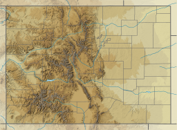
The Gunnison River is located in western Colorado, United States and is one of the largest tributaries of the Colorado River.

<span class="mw-page-title-main">National recreation area</span> Type of protected area in the United States

A national recreation area (NRA) is a protected area in the United States established by an Act of Congress to preserve enhanced recreational opportunities in places with significant natural and scenic resources. There are 40 NRAs, which emphasize a variety of activities for visitors, including hiking, camping, boating, fishing, swimming, biking, horseback riding, and wildlife viewing, in areas that include multiple-use management for both conservation and limited utilization of natural resources. They have diverse features and contexts, being established around reservoirs, in urban areas, and within forests. Due to their size, diversity of activities, and proximity to population centers, NRAs are among the most visited units of the National Park System, with six among the thirty most visited sites.

<span class="mw-page-title-main">Curecanti National Recreation Area</span>

Curecanti National Recreation Area is a National Park Service unit located on the Gunnison River in western Colorado. Established in 1965, Curecanti National Recreation Area is responsible for developing and managing recreational facilities on three reservoirs, Blue Mesa Reservoir, Morrow Point Reservoir and Crystal Reservoir, constructed on the upper Gunnison River in the 1960s by the U.S. Bureau of Reclamation to better utilize the vital waters of the Colorado River and its major tributaries. A popular destination for boating and fishing, Curecanti offers visitors two marinas, traditional and group campgrounds, hiking trails, boat launches, and boat-in campsites. The state's premiere lake trout and Kokanee salmon fisheries, Curecanti is a popular destination for boating and fishing, and is also a popular area for ice-fishing in the winter months.

<span class="mw-page-title-main">Blue Mesa Dam</span> Dam in Colorado, United States

Blue Mesa Dam is a 390-foot-tall (120 m) zoned earthfill dam on the Gunnison River in Colorado. It creates Blue Mesa Reservoir, and is within Curecanti National Recreation Area just before the river enters the Black Canyon of the Gunnison. The dam is upstream of the Morrow Point Dam. Blue Mesa Dam and reservoir are part of the Bureau of Reclamation's Wayne N. Aspinall Unit of the Colorado River Storage Project, which retains the waters of the Colorado River and its tributaries for agricultural and municipal use in the American Southwest. Although the dam does produce hydroelectric power, its primary purpose is water storage. State Highway 92 passes over the top of the dam. Blue Mesa Dam houses two turbine generators and produces an average of 264,329,000 kilowatt-hours each year.

<span class="mw-page-title-main">Morrow Point Dam</span> Dam on the Gunnison River in Colorado

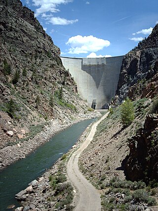
Morrow Point Dam is a 468-foot-tall (143 m) concrete double-arch dam on the Gunnison River located in Colorado, the first dam of its type built by the U.S. Bureau of Reclamation. Located in the upper Black Canyon of the Gunnison, it creates Morrow Point Reservoir, and is within the National Park Service-operated Curecanti National Recreation Area. The dam is between the Blue Mesa Dam (upstream) and the Crystal Dam (downstream). Morrow Point Dam and reservoir are part of the Bureau of Reclamation's Wayne N. Aspinall Unit of the Colorado River Storage Project, which retains the waters of the Colorado River and its tributaries for agricultural and municipal use in the American Southwest. The dam's primary purpose is hydroelectric power generation.

<span class="mw-page-title-main">Middle Bridge (Colorado)</span> Bridge in Colorado, United States

Middle Bridge is the crossing of Blue Mesa Reservoir on U.S. Route 50 (US 50) within the Curecanti National Recreation Area in southwest Gunnison County, Colorado, United States, about 2.5 miles (4.0 km) east-northeast of the community of Sapinero.

<span class="mw-page-title-main">Crystal Dam</span> Dam on the Gunnison River in Colorado, United States

Crystal Dam is a 323-foot-tall (98 m), double-curvature, concrete, thin arch dam located 6 miles downstream from Morrow Point Dam on the Gunnison River in Colorado, United States. Crystal Dam is the newest of the three dams in Curecanti National Recreation Area; construction on the dam was finished in 1976. The dam impounds Crystal Reservoir. Crystal Dam and Reservoir are part of the Bureau of Reclamation's Wayne N. Aspinall Unit of the Colorado River Storage Project, which retains the waters of the Gunnison River and its tributaries for agricultural and municipal use in the American Southwest. The dam's primary purpose is hydroelectric power generation.

<span class="mw-page-title-main">Gunnison Tunnel</span> United States historic place

The Gunnison Tunnel is an irrigation tunnel constructed between 1905 and 1909 by the U.S. Bureau of Reclamation in Montrose County, Colorado. The 5.8-mile-long (9.3 km) tunnel diverts water from the Gunnison River to the arid Uncompahgre Valley around Montrose, Colorado.

<span class="mw-page-title-main">Colorado River Storage Project</span> US Bureau of Reclamation project

The Colorado River Storage Project is a United States Bureau of Reclamation project designed to oversee the development of the upper basin of the Colorado River. The project provides hydroelectric power, flood control and water storage for participating states along the upper portion of the Colorado River and its major tributaries.

<span class="mw-page-title-main">Curecanti Needle</span>

The Curecanti Needle is a 700-ft granite spire located on the Gunnison River in western Colorado. A notable landmark to generations of natives and pioneers, the Needle is located on the southern bank of Morrow Point Reservoir, an impoundment of the Gunnison river between Gunnison and Montrose, Colorado. Used for many years as an advertising symbol for the Denver and Rio Grande Western Railroad, whose narrow-gauge railway famously ran along the northern bank of the river and passed near the Needle, the spire is today part of the Curecanti National Recreation Area, a National Park Service facility that encompasses three impoundments of the Gunnison river, including Morrow Point Reservoir.

<span class="mw-page-title-main">Lake Pueblo State Park</span> State park in Colorado, United States

Lake Pueblo State Park is a state park located in Pueblo County, Colorado. It includes 60 miles (97 km) of shoreline and 10,000 acres (40 km2) of land. Activities it offers include two full-service marinas, recreational fishing, hiking, camping and swimming at a special swim beach.

<span class="mw-page-title-main">Morrow Point Reservoir</span> Reservoir on the Gunnison River in Colorado

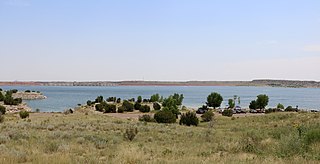
Morrow Point Reservoir is an 817-acre (331 ha) artificial reservoir on the Gunnison River in western Colorado. Located in the upper Black Canyon of the Gunnison, the lake was created in 1968 by the U.S. Bureau of Reclamation as part of a larger plan to impound the upper section of the Gunnison and create opportunities for hydroelectric power generation, water conservation, and recreation. Morrow Point Reservoir is managed by the National Park Service as a unit within the Curecanti National Recreation Area, and is the location of the Curecanti Needle, a striking 700-foot (210 m) granite spire on the reservoir's southern bank whose unique shape was for decades a recognized symbol of the Denver and Rio Grande Western Railroad.

Crystal Reservoir is a 340-acre artificial reservoir on the Gunnison River in western Colorado. Located in the upper Black Canyon of the Gunnison, the lake was created in 1976 by the U.S. Bureau of Reclamation as part of a larger plan to impound the upper section of the Gunnison for the generation of hydroelectric power, water storage, and public recreation. Crystal Reservoir is managed by the National Park Service as an element of the Curecanti National Recreation Area. Located at the far western end of Curecanti, Crystal Reservoir is the smallest, least developed, and least accessible of the three reservoirs within the park.

Silver Jack Dam is a dam in Gunnison County, Colorado.

<span class="mw-page-title-main">Sugar Pine Reservoir</span> Reservoir in Northern California

Sugar Pine Reservoir is a reservoir in Placer County, California, located approximately 7 miles (11 km) north of Foresthill. The reservoir was flooded in 1982, and today supplies water to the community of Foresthill and hosts a number of recreation facilities.

<span class="mw-page-title-main">Taylor Park Dam</span> Dam in Almont, Colorado

Part of the Uncompahgre Project located on the western slope of central Colorado, the Taylor Park Dam was engineered by the Bureau of Reclamation. It is located on the Taylor River, a tributary of the Gunnison River, and the dam is used to create the Taylor Park Reservoir in Gunnison County, Colorado.

<span class="mw-page-title-main">Blue Creek (Gunnison River tributary)</span> River

Blue Creek is a tributary of the Gunnison River in Gunnison County, Colorado. It forms at the confluence of Little Blue Creek and Big Blue Creek adjacent to the intersection of U.S. Highway 50 and Alpine Plateau Road in Blue Creek Canyon.

References

  1. Region, Bureau of Reclamation Upper Colorado. "CRSP, Blue Mesa Dam - Reclamation, Upper Colorado Region". www.usbr.gov. Archived from the original on 2016-09-29. Retrieved 2017-05-24.
  2. Reclamation, Bureau of. "Aspinall Unit - UC Region - Bureau of Reclamation". www.usbr.gov.
  3. Reclamation, Bureau of. "Colorado River Storage Project - UC Region - Bureau of Reclamation". www.usbr.gov.
  4. Reclamation, Bureau of. "Aspinall Unit - UC Region - Bureau of Reclamation". www.usbr.gov.
  5. Reclamation, Bureau of. "Aspinall Unit - UC Region - Bureau of Reclamation". www.usbr.gov.
  6. 1 2 "NOAA Online Weather Data". National Weather Service. Retrieved August 11, 2022.
  7. "U.S. Climate Normals Quick Access". National Oceanic and Atmospheric Administration. Retrieved August 11, 2022.
  8. "Boating - Curecanti National Recreation Area (U.S. National Park Service)". www.nps.gov.
  9. "Camping - Curecanti National Recreation Area (U.S. National Park Service)". www.nps.gov.
  10. "Camping By Boat - Curecanti National Recreation Area (U.S. National Park Service)". www.nps.gov.
  11. Sakas, Michael Elizabeth. "The marinas at Colorado's Blue Mesa Reservoir won't open this season as the threat of a water release to Lake Powell looms". Colorado Public Radio. Retrieved 2022-05-28.
  12. "Black Canyon Of The Gunnison National Park (U.S. National Park Service)". www.nps.gov.
  13. "Grand Mesa Uncompahgre and Gunnison National Forests - Camping & Cabins:Campground Camping". Fs.usda.gov. Retrieved 2022-09-16.