
The Salt River is a river in Gila and Maricopa counties in Arizona, United States, that is the largest tributary of the Gila River. The river is about 200 miles (320 km) long. Its drainage basin is about 13,700 square miles (35,000 km2) large. The longest of the Salt River's many tributaries is the 195-mile (314 km) Verde River. The Salt's headwaters tributaries, the Black River and East Fork, increase the river's total length to about 300 miles (480 km). The name Salt River comes from the fact that the river flows over large salt deposits shortly after the merging of the White and Black Rivers.

Donner Lake is a freshwater lake in Northeast California on the eastern slope of the Sierra Nevada and about 20 miles (32 km) northwest of the much larger Lake Tahoe. A moraine serves as a natural dam for the lake. The lake is located in the town of Truckee, between Interstate 80 to the north and Schallenberger Ridge to the south. The tracks of the Union Pacific Railroad run along Schallenberger Ridge and closely follow the route of the original transcontinental railroad. The historic route of the Lincoln Highway, the first automobile road across America and US 40 follows the northern shoreline, then climbs to Donner Pass from where the entire lake may be viewed.

Tempe Town Lake is an artificial perennial reservoir located just north of Tempe Butte at the confluence of the intermittent Salt River and the ephemeral Indian Bend Wash in Tempe, Arizona, United States. The reservoir receives much of its water from the Colorado River via the Central Arizona Project.

Saguaro Lake is the fourth reservoir on the Salt River, formed by the Stewart Mountain Dam in the U.S. state of Arizona. The lake is off State Route 87, about halfway between Phoenix and the ghost town of Sunflower. The dammed end of the lake is at 33.5656°N 111.5361°W, at an elevation of 1,506 feet (459 m).

Lake Havasu is a large reservoir formed by Parker Dam on the Colorado River, on the border between San Bernardino County, California and Mohave County, Arizona, Arizona. Lake Havasu City sits on the Arizona (eastern) side of the lake with its Californian counterpart of Havasu Lake directly across the lake. The reservoir has an available capacity of 619,400 acre-feet (764,000,000 m3). The concrete arch dam was built by the United States Bureau of Reclamation between 1934 and 1938. The lake's primary purpose is to store water for pumping into two aqueducts. Prior to the dam construction, the area was home to the Mojave people. The lake was named after the Mojave word for blue. In the early 19th century, it was frequented by beaver trappers. Spaniards also began to mine the areas along the river.

Luna Lake is a natural body of water that covers approximately 75 acres (0.30 km2) of land. It is located about three miles (5 km) southeast of Alpine, Arizona, at the elevation of 7,890 ft (2,400 m), and is the centerpiece of the Luna Lake Wildlife Area.
Show Low Lake is a 100-acre (0.40 km2) lake nestled at 6,500 feet (2,000 m) elevation in the White Mountains of Arizona which is administered by the Arizona Game and Fish Department along with the city of Show Low. Show Low Lake Park is located five miles (8 km) south of Show Low.

Alamo Lake State Park is a state park of Arizona, USA, centered on Alamo Lake, a flood control and recreational reservoir. The park is located in western Arizona about 38 miles (61 km) north of Wenden. It is accessed via a paved two-lane road off either U.S. Route 60 to the south or U.S. Route 93 to the east. Owing to its remoteness, the park is often considered one of the "best kept secrets" of the state park system.
Becker Lake is a reservoir managed as a trophy trout lake. Located near Springerville, Arizona, Becker Lake is part of the 622-acre (252 ha) Becker Lake Wildlife Area. Built around the year 1880, it is one of the oldest reservoirs in the White Mountains. The Arizona Game and Fish Department acquired the lake and property around it in 1973. The lake is located at 6,910 feet (2,110 m).
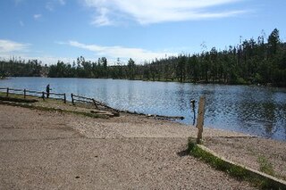
Black Canyon Lake is a lake in Navajo County, Arizona, United States.
Bunch Reservoir is one of a trio of lakes on the Little Colorado River that provides trout fishing opportunities in and around the town of Greer.
Carnero Lake is a high elevation shallow lake in Apache County, Arizona. Built in 1979, the lake quickly became popular with anglers, to the dismay of downstream water users. Because of the dispute, the Arizona Game and Fish discontinued stocking for many years. In 1999, the Arizona Game and Fish has acquired a major share of the water rights, setting the stage for a new and vigorous trout fishery.
Concho Lake is an irrigation reservoir situated in the town of Concho, in the eastern Arizona grasslands at 6,300 feet (1,900 m). Much of the surrounding land is privately owned; the rest is owned by the Bureau of Land Management, but is managed for sport fisheries and wildlife resources by the Arizona Game and Fish.
Nelson Reservoir is a reservoir located in Apache County, Arizona between Springerville and Alpine. The Reservoir is a long and narrow lake which follows the Nutrioso Creek Valley for nearly a mile. Fish that remain in Nelson Reservoir after summer stockings can grow to good size, making it a popular fishing site with local anglers.
Rainbow Lake is a 116-acre manmade lake near the town of Pinetop-Lakeside in southern Navajo County, Arizona, United States. The lake was created in 1903 when Mormon settlers dammed Walnut Creek, a tributary of the Little Colorado River, to impound water for irrigation.
Built in 1928, Scott Reservoir is an irrigation impoundment on Porter Creek near Pinetop-Lakeside, Arizona, USA. The least developed of the "in town" lakes, trees surround Scott Reservoir. It lies just outside the town limits on the Apache-Sitgreaves National Forests.
Located in the heart of Pinetop-Lakeside, Woodland Lake and the park surrounding it have been called the town's "Crown Jewel." In addition to trout fishing, the lake provides a host of other outdoor recreation opportunities. Woodland Lake lies on Apache-Sitgreaves National Forests property, just west of White Mountain Blvd. in Pinetop.
Lee Valley Lake is Arizona's highest elevation reservoir, situated at 9,420 feet (2,870 m) in the Apache-Sitgreaves National Forests near Mount Baldy. It is located approximately 35 miles from Pinetop-Lakeside, connected by Arizona highways 260 and 273 and forest road 113. Access is restricted in the winter when roads are closed due to snow, generally December to early April.

Fool Hollow Lake is a public lake located in Navajo County, Arizona, near the city of Show Low. The lake is operated by the Arizona State Parks Department, and consists of 150 acres (61 ha), with an average depth of 23 feet (7.0 m) together with a variety of fish species.
Fishing in Colorado has brought in a large amount of revenue for the state. In 2019 Colorado Parks and Wildlife estimated outdoor recreation contributed roughly 62 billion dollars to the state economy. Fishing was reported to be the 5th most popular outdoor activity and 110, 511 fishing and hunting combination licenses were sold. Ice fishing makes up part of this total fishing revenue and is a common annual sport for Colorado residents and out-of-state visitors. There is no legal definition of ice fishing season. Rather, people begin to ice fish once the lakes freeze over with thick enough ice. Colorado Parks and Wildlife also recommend that people always ice-fish with another person. Typically, this starts in December and ends in April for Colorado. Lakes size, depth, elevation, and seasonal weather can cause variance to the season. Once the lakes freeze over with thick enough ice, anglers go out onto the ice, drill holes through the ice, and fish for a variety of species.


