Salt Lake County is located in the U.S. state of Utah. As of the 2020 United States census, the population was 1,185,238, making it the most populous county in Utah. Its county seat and largest city is Salt Lake City, the state capital. The county was created in 1850. Salt Lake County is the 37th most populated county in the United States and is one of four counties in the Rocky Mountains to make it into the top 100. Salt Lake County has been the only county of the first class in Utah – under the Utah Code is a county with a population of 700,000 or greater. Although, Utah County directly to the south has recently reached this threshold.
Cottonwood West was a census-designated place (CDP) in Salt Lake County, Utah, United States. The CDP was situated between the cities of Holladay and Murray, which by the mid-2000s had annexed virtually all of the area between them.

Holladay is a city in central Salt Lake County, Utah, United States. It is part of the Salt Lake City, Utah Metropolitan Statistical Area and abuts the Wasatch National Forest. The population was 31,965 at the 2020 census, a significant increase from 14,561 in 2000 when the first area incorporated from Salt Lake County. The city was incorporated on November 29, 1999, as Holladay-Cottonwood, and the name was shortened to Holladay on December 14 of that year. It was reported in the 1990 census as the Holladay-Cottonwood CDP.

Magna is a metro township in Salt Lake County, Utah, United States. The current population of the township stands at 29,251 according to the 2020 census, a 10.4% increase over 26,505 in 2010.

Millcreek is a city in Salt Lake County, Utah, United States, and is part of the Salt Lake City Metropolitan Statistical Area. The population as of the 2020 Census was 63,380. Prior to its incorporation on December 28, 2016, Millcreek was a census-designated place (CDP) and township.

Murray is a city situated on the Wasatch Front in the core of Salt Lake Valley in the U.S. state of Utah. Named for territorial governor Eli Murray, it is the state's fourteenth largest city. According to the 2020 census, Murray had a population of 50,637. Murray shares borders with Taylorsville, Holladay, South Salt Lake and West Jordan, Utah. Once teeming with heavy industry, Murray's industrial sector now has little trace and has been replaced by major mercantile sectors. Known for its central location in Salt Lake County, Murray has been called the Hub of Salt Lake County. Unlike most of its neighboring communities, Murray operates its own police, fire, power, water, library, and parks and recreation departments and has its own school district. While maintaining many of its own services, Murray has one of the lowest city tax rates in the state.

Sandy is a city in the Salt Lake City metropolitan area, located in Salt Lake County, Utah, United States. The population of Sandy was 87,461 at the 2010 census, making it the sixth-largest city in Utah. The population is currently estimated to be about 96,380 according to the July 1, 2019 United States Census estimates.

South Jordan is a city in south central Salt Lake County, Utah, United States, 18 miles (29 km) south of Salt Lake City. Part of the Salt Lake City metropolitan area, the city lies in the Salt Lake Valley along the banks of the Jordan River between the 10,000-foot (3,000 m) Oquirrh Mountains and the 11,000-foot (3,400 m) Wasatch Mountains. The city has 3.5 miles (5.6 km) of the Jordan River Parkway that contains fishing ponds, trails, parks, and natural habitats. The Salt Lake County fair grounds and equestrian park, 67-acre (27 ha) Oquirrh Lake, and 37 public parks are located inside the city. As of 2020, there were 77,487 people in South Jordan.
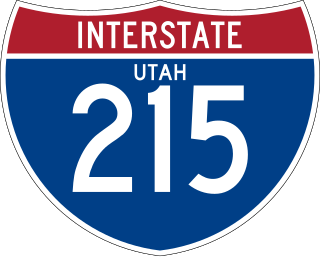
Interstate 215 (I-215), also known locally as the Belt Route, is an auxiliary Interstate in the U.S. state of Utah that forms a three-quarters loop around Salt Lake City and many of its suburbs. The route begins at the mouth of Parley's Canyon at a junction with I-80 east of the city center, and heads south through the edge of the Salt Lake City metropolitan area's eastern suburbs of Millcreek, Holladay, and Cottonwood Heights. It continues west through Murray before turning north again, passing through the city's first-ring western suburbs of Taylorsville and West Valley City. It then enters North Salt Lake and Davis County for a short distance before reaching I-15 northwest of the city center.
The Granite School District spreads across central Salt Lake County, Utah, serving West Valley City, Millcreek, Taylorsville, South Salt Lake, and Holladay; Kearns and Magna Townships; and parts of West Jordan, Murray and Cottonwood Heights. About 67,000 students are enrolled in its programs ranging from kindergarten to twelfth grade. It operates 9 high schools, 15 junior high schools, 62 elementary schools, as well as several specialty schools. This makes Granite the third largest school district in the state of Utah behind Alpine School District in Utah County and Davis County School District. Other school districts in the area include the Salt Lake City School District and the Murray School District.

Big Cottonwood Canyon is a canyon in the Wasatch Range 12 miles (19 km) southeast of Salt Lake City in the U.S. state of Utah. The 15-mile (24 km)-long canyon provides hiking, biking, picnicking, rock-climbing, camping, and fishing in the summer. Its two ski resorts, Brighton and Solitude, are popular among skiers and snowboarders. The canyon is accessed by The Big Cottonwood Canyon Scenic Byway (SR-190), which runs its length to Guardsman Pass at the top of the canyon, allowing travel to Park City in the summer months.
Brighton High School in Cottonwood Heights, Utah is located about ten miles (16 km) south of Salt Lake City. It serves students in grades 9-12 for the Canyons School District.
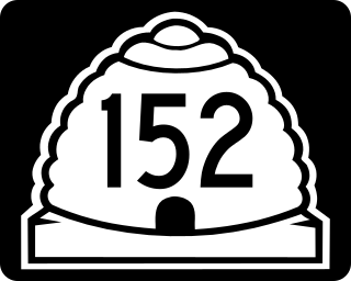
State Route 152 (SR-152) is a state highway in the suburbs of Salt Lake City, Utah connecting SR-71 in Murray to I-215 and city-maintained Highland Drive in Cottonwood Heights, though for almost all of its length it forms the border between Murray and Holladay. The route, which is 3.04 miles (4.89 km), is laid on the entire length of the Van Winkle Expressway and a portion of Highland Drive.
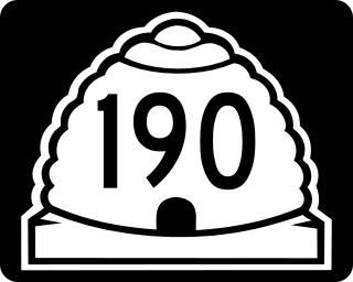
State Route 190 (SR-190) or the Big Cottonwood Canyon Scenic Byway is primarily an east and west state highway and scenic highway in eastern Salt Lake County, Utah, United States, that begins at Interstate 215 (I-215), runs through Big Cottonwood Canyon, and ends at the Salt Lake and Wasatch county line.
Canyons School District is a school district in the southeastern portion of Salt Lake County in Utah, United States. The district includes the cities of Cottonwood Heights, the Salt Lake County section of Draper, Midvale and Sandy and the townships of Alta, Brighton and White City. Residents of those communities voted to create the district in 2007, making Canyons the first school district to be formed in the state in almost a century. Canyons has approximately 34,000 students in 50 schools. There are 29 elementary schools, eight middle schools, five traditional high schools, and eight special programs schools, including one technical school, a special education school and a high school for adults in prison. The district covers 192 square miles and employs 6,000 people.

Big Cottonwood Creek is located in the Wasatch Mountains just east of Salt Lake City. It is part of the Big Cottonwood Creek Watershed, which ranges in elevation from 5,000 to 10,500 feet with the headwaters around 9,600 feet. The creek flows through the Big Cottonwood Canyon in a westerly direction until it emerges into Salt Lake Valley about eighteen miles (29 km) from its highest source. Thence its course is northwesterly through Cottonwood Heights, Holladay, and Murray, Utah for a little over twenty-four miles miles from the headwaters until it empties into the Jordan River about five miles (8.0 km) south of Salt Lake City. The water eventually flows into the Great Salt Lake. In the summer, its waters are all used for irrigation purposes. From its source to its original outlet in the Jordan River is about twenty-six miles.

Fort Union, historically Union, is a major commercial area and an early settlement in the Salt Lake Valley of Utah that is now split between the municipalities of Midvale, Cottonwood Heights, and Sandy. The fort after which the area was named was built early (1853) in the Salt Lake Valley's post-1847 history at a strategic point where escarpments on either side of the Little Cottonwood Creek valley create a narrow gateway to the upper valley and Little Cottonwood Canyon beyond. The effects of geography on travel through the area have also contributed to the area's much more recent success as a retail and employment destination.
Ivory Homes is an American housing construction company, active mainly in Utah. In 2017 it was in 60th place on a list of such companies by size in the United States.
Cottonwood, Utah, has historically referred to a vaguely defined area between and around Big Cottonwood Creek and Little Cottonwood Creek in the Salt Lake Valley:

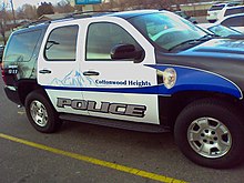
The Unified Police Department of Greater Salt Lake (UPD) is a police department located in Salt Lake County, Utah, United States.