Fault (geology)

Last updated

Satellite image of a fault in the Taklamakan Desert. The two colorful ridges (at bottom left and top right) used to form a single continuous line, but have been split apart by movement along the fault. Piqiang Fault, China detail.jpg
Satellite image of a fault in the Taklamakan Desert. The two colorful ridges (at bottom left and top right) used to form a single continuous line, but have been split apart by movement along the fault.

In geology, a fault is a planar fracture or discontinuity in a volume of rock across which there has been significant displacement as a result of rock-mass movements. Large faults within Earth's crust result from the action of plate tectonic forces, with the largest forming the boundaries between the plates, such as the megathrust faults of subduction zones or transform faults. [1] Energy release associated with rapid movement on active faults is the cause of most earthquakes. Faults may also displace slowly, by aseismic creep. [2]

Contents

A fault plane is the plane that represents the fracture surface of a fault. A fault trace or fault line is a place where the fault can be seen or mapped on the surface. A fault trace is also the line commonly plotted on geologic maps to represent a fault. [3] [4]

A fault zone is a cluster of parallel faults. [5] [6] However, the term is also used for the zone of crushed rock along a single fault. [7] Prolonged motion along closely spaced faults can blur the distinction, as the rock between the faults is converted to fault-bound lenses of rock and then progressively crushed. [8]

Mechanisms of faulting

Normal fault in La Herradura Formation, Morro Solar, Peru. The light layer of rock shows the displacement. A second normal fault is at the right. Falla normal Morro Solar Peru.jpg
Normal fault in La Herradura Formation, Morro Solar, Peru. The light layer of rock shows the displacement. A second normal fault is at the right.

Due to friction and the rigidity of the constituent rocks, the two sides of a fault cannot always glide or flow past each other easily, and so occasionally all movement stops. The regions of higher friction along a fault plane, where it becomes locked, are called asperities . Stress builds up when a fault is locked, and when it reaches a level that exceeds the strength threshold, the fault ruptures and the accumulated strain energy is released in part as seismic waves, forming an earthquake. [2]

Strain occurs accumulatively or instantaneously, depending on the liquid state of the rock; the ductile lower crust and mantle accumulate deformation gradually via shearing, whereas the brittle upper crust reacts by fracture – instantaneous stress release – resulting in motion along the fault. [9] A fault in ductile rocks can also release instantaneously when the strain rate is too great.

Slip, heave, throw

A fault in Morocco. The fault plane is the steeply leftward-dipping line in the centre of the photo, which is the plane along which the rock layers to the left have slipped downwards, relative to the layers to the right of the fault. Fault in Seppap Gorge Morocco.jpg
A fault in Morocco. The fault plane is the steeply leftward-dipping line in the centre of the photo, which is the plane along which the rock layers to the left have slipped downwards, relative to the layers to the right of the fault.
Normal fault and drag folds (eastern flanks of the Bighorn Mountains, Wyoming, US) Normal fault & drag folds (eastern flanks of the Bighorn Mountains, Wyoming, USA).jpg
Normal fault and drag folds (eastern flanks of the Bighorn Mountains, Wyoming, US)
Microfault showing a piercing point (the coin's diameter is 18 mm (0.71 in)) Microfault.jpg
Microfault showing a piercing point (the coin's diameter is 18 mm (0.71 in))

Slip is defined as the relative movement of geological features present on either side of a fault plane. A fault's sense of slip is defined as the relative motion of the rock on each side of the fault concerning the other side. [10] In measuring the horizontal or vertical separation, the throw of the fault is the vertical component of the separation and the heave of the fault is the horizontal component, as in "Throw up and heave out". [11] The vector of slip can be qualitatively assessed by studying any drag folding of strata, which may be visible on either side of the fault. [12] Drag folding is a zone of folding close to a fault that likely arises from frictional resistance to movement on the fault. [13] The direction and magnitude of heave and throw can be measured only by finding common intersection points on either side of the fault (called a piercing point). In practice, it is usually only possible to find the slip direction of faults, and an approximation of the heave and throw vector.

Hanging wall and footwall

The two sides of a non-vertical fault are known as the hanging wall and footwall. The hanging wall occurs above the fault plane and the footwall occurs below it. [14] This terminology comes from mining: when working a tabular ore body, the miner stood with the footwall under his feet and with the hanging wall above him. [15] These terms are important for distinguishing different dip-slip fault types: reverse faults and normal faults. In a reverse fault, the hanging wall displaces upward, while in a normal fault the hanging wall displaces downward. Distinguishing between these two fault types is important for determining the stress regime of the fault movement.

Fault types

Faults are mainly classified in terms of the angle that the fault plane makes with the Earth's surface, known as the dip, and the direction of slip along the fault plane. [16] Based on the direction of slip, faults can be categorized as:

Strike-slip faults

Schematic illustration of the two strike-slip fault types, as seen from above Strike slip fault.png
Schematic illustration of the two strike-slip fault types, as seen from above

In a strike-slip fault (also known as a wrench fault, tear fault or transcurrent fault), [17] the fault surface (plane) is usually near vertical, and the footwall moves laterally either left or right with very little vertical motion. Strike-slip faults with left-lateral motion are also known as sinistral faults and those with right-lateral motion as dextral faults. [18] Each is defined by the direction of movement of the ground as would be seen by an observer on the opposite side of the fault.

A special class of strike-slip fault is the transform fault when it forms a plate boundary. This class is related to an offset in a spreading center, such as a mid-ocean ridge, or, less common, within continental lithosphere, such as the Dead Sea Transform in the Middle East or the Alpine Fault in New Zealand. Transform faults are also referred to as "conservative" plate boundaries since the lithosphere is neither created nor destroyed.

Dip-slip faults

Normal faults in Spain, between which rock layers have slipped downwards (at photo's centre) Normal faults - Arganda del Rey, Madrid, Spain.JPG
Normal faults in Spain, between which rock layers have slipped downwards (at photo's centre)

Dip-slip faults can be either normal ("extensional") or reverse.

Cross-sectional illustration of normal and reverse dip-slip faults Nor rev.png
Cross-sectional illustration of normal and reverse dip-slip faults

In a normal fault, the hanging wall moves downward, relative to the footwall. A downthrown block between two normal faults dipping towards each other is a graben. An upthrown block between two normal faults dipping away from each other is a horst. The dip of most normal faults is at least 60 degrees but some normal faults dip at less than 45 degrees. [19] Low-angle normal faults with regional tectonic significance may be designated detachment faults.

A reverse fault is the opposite of a normal fault—the hanging wall moves up relative to the footwall. Reverse faults indicate compressive shortening of the crust. The terminology of "normal" and "reverse" comes from coal mining in England, where normal faults are the most common. [20]

A thrust fault has the same sense of motion as a reverse fault, but with the dip of the fault plane at less than 45°. [21] [22] Thrust faults typically form ramps, flats and fault-bend (hanging wall and footwall) folds.

Thrust with fault bend fold.svg

A section of a hanging wall or foot wall where a thrust fault formed along a relatively weak bedding plane is known as a flat and a section where the thrust fault cut upward through the stratigraphic sequence is known as a ramp. [23] Typically, thrust faults move within formations by forming flats and climbing up sections with ramps. This results in the hanging wall flat (or a portion thereof) lying atop the foot wall ramp as shown in the fault-bend fold diagram.

Fault-bend folds are formed by the movement of the hanging wall over a non-planar fault surface and are found associated with both extensional and thrust faults.

Faults may be reactivated at a later time with the movement in the opposite direction to the original movement (fault inversion). A normal fault may therefore become a reverse fault and vice versa.

Thrust faults form nappes and klippen in the large thrust belts. Subduction zones are a special class of thrusts that form the largest faults on Earth and give rise to the largest earthquakes.

Oblique-slip faults

Oblique-slip fault Oblique slip fault.svg
Oblique-slip fault

A fault which has a component of dip-slip and a component of strike-slip is termed an oblique-slip fault. Nearly all faults have some component of both dip-slip and strike-slip; hence, defining a fault as oblique requires both dip and strike components to be measurable and significant. Some oblique faults occur within transtensional and transpressional regimes, and others occur where the direction of extension or shortening changes during the deformation but the earlier formed faults remain active.

The hade angle is defined as the complement of the dip angle; it is the angle between the fault plane and a vertical plane that strikes parallel to the fault.

Listric fault

Listric fault (red line) Rollover.png
Listric fault (red line)

Listric faults are similar to normal faults but the fault plane curves, the dip being steeper near the surface, then shallower with increased depth. The dip may flatten into a sub-horizontal décollement, resulting in a horizontal slip on a horizontal plane. The illustration shows the slumping of the hanging wall along a listric fault. Where the hanging wall is absent (such as on a cliff) the footwall may slump in a manner that creates multiple listric faults.

Ring fault

Ring faults, also known as caldera faults, are faults that occur within collapsed volcanic calderas [24] and the sites of bolide strikes, such as the Chesapeake Bay impact crater. Ring faults are the result of a series of overlapping normal faults, forming a circular outline. Fractures created by ring faults may be filled by ring dikes. [24]

Synthetic and antithetic faults

Synthetic and antithetic are terms used to describe minor faults associated with a major fault. Synthetic faults dip in the same direction as the major fault while the antithetic faults dip in the opposite direction. These faults may be accompanied by rollover anticlines (e.g. the Niger Delta Structural Style).

Fault rock

Structure of Fault FaultZone.jpg
Structure of Fault
Salmon-colored fault gouge and associated fault separates two different rock types on the left (dark gray) and right (light gray). From the Gobi of Mongolia. FaultGouge.JPG
Salmon-colored fault gouge and associated fault separates two different rock types on the left (dark gray) and right (light gray). From the Gobi of Mongolia.
Inactive fault from Sudbury to Sault Ste. Marie, Northern Ontario, Canada CREIGHTON-fault-sudbury-basin-science-north.jpg
Inactive fault from Sudbury to Sault Ste. Marie, Northern Ontario, Canada

All faults have a measurable thickness, made up of deformed rock characteristic of the level in the crust where the faulting happened, of the rock types affected by the fault and of the presence and nature of any mineralising fluids. Fault rocks are classified by their textures and the implied mechanism of deformation. A fault that passes through different levels of the lithosphere will have many different types of fault rock developed along its surface. Continued dip-slip displacement tends to juxtapose fault rocks characteristic of different crustal levels, with varying degrees of overprinting. This effect is particularly clear in the case of detachment faults and major thrust faults.

The main types of fault rock include:

Impacts on structures and people

In geotechnical engineering, a fault often forms a discontinuity that may have a large influence on the mechanical behavior (strength, deformation, etc.) of soil and rock masses in, for example, tunnel, foundation, or slope construction.

The level of a fault's activity can be critical for (1) locating buildings, tanks, and pipelines and (2) assessing the seismic shaking and tsunami hazard to infrastructure and people in the vicinity. In California, for example, new building construction has been prohibited directly on or near faults that have moved within the Holocene Epoch (the last 11,700 years) of the Earth's geological history. [27] Also, faults that have shown movement during the Holocene plus Pleistocene Epochs (the last 2.6 million years) may receive consideration, especially for critical structures such as power plants, dams, hospitals, and schools. Geologists assess a fault's age by studying soil features seen in shallow excavations and geomorphology seen in aerial photographs. Subsurface clues include shears and their relationships to carbonate nodules, eroded clay, and iron oxide mineralization, in the case of older soil, and lack of such signs in the case of younger soil. Radiocarbon dating of organic material buried next to or over a fault shear is often critical in distinguishing active from inactive faults. From such relationships, paleoseismologists can estimate the sizes of past earthquakes over the past several hundred years, and develop rough projections of future fault activity.

Faults and ore deposits

Many ore deposits lie on or are associated with faults. This is because the fractured rock associated with fault zones allow for magma ascent [28] or the circulation of mineral-bearing fluids. Intersections of near-vertical faults are often locations of significant ore deposits. [29]

An example of a fault hosting valuable porphyry copper deposits is northern Chile's Domeyko Fault with deposits at Chuquicamata, Collahuasi, El Abra, El Salvador, La Escondida and Potrerillos. [30] Further south in Chile Los Bronces and El Teniente porphyry copper deposit lie each at the intersection of two fault systems. [29]

Faults may not always act as conduits to surface. It has been proposed that deep-seated "misoriented" faults may instead be zones where magmas forming porphyry copper stagnate achieving the right time for—and type of—igneous differentiation. [31] At a given time differentiated magmas would burst violently out of the fault-traps and head to shallower places in the crust where porphyry copper deposits would be formed. [31]

Groundwater

As faults are zones of weakness, they facilitate the interaction of water with the surrounding rock and enhance chemical weathering. The enhanced chemical weathering increases the size of the weathered zone and hence creates more space for groundwater. [32] Fault zones act as aquifers and also assist groundwater transport.

See also

Related Research Articles

<span class="mw-page-title-main">Earthquake</span> Sudden movement of the Earths crust

An earthquake – also called a quake, tremor, or temblor – is the shaking of the Earth's surface resulting from a sudden release of energy in the lithosphere that creates seismic waves. Earthquakes can range in intensity, from those so weak they cannot be felt, to those violent enough to propel objects and people into the air, damage critical infrastructure, and wreak destruction across entire cities. The seismic activity of an area is the frequency, type, and size of earthquakes experienced over a particular time. The seismicity at a particular location in the Earth is the average rate of seismic energy release per unit volume.

<span class="mw-page-title-main">Structural geology</span> Science of the description and interpretation of deformation in the Earths crust

Structural geology is the study of the three-dimensional distribution of rock units with respect to their deformational histories. The primary goal of structural geology is to use measurements of present-day rock geometries to uncover information about the history of deformation (strain) in the rocks, and ultimately, to understand the stress field that resulted in the observed strain and geometries. This understanding of the dynamics of the stress field can be linked to important events in the geologic past; a common goal is to understand the structural evolution of a particular area with respect to regionally widespread patterns of rock deformation due to plate tectonics.

<span class="mw-page-title-main">Thrust fault</span> Type of reverse fault that has a dip of 45 degrees or less

A thrust fault is a break in the Earth's crust, across which older rocks are pushed above younger rocks.

<span class="mw-page-title-main">Fold (geology)</span> Stack of originally planar surfaces

In structural geology, a fold is a stack of originally planar surfaces, such as sedimentary strata, that are bent or curved ("folded") during permanent deformation. Folds in rocks vary in size from microscopic crinkles to mountain-sized folds. They occur as single isolated folds or in periodic sets. Synsedimentary folds are those formed during sedimentary deposition.

<span class="mw-page-title-main">Moine Thrust Belt</span> Fault in Highland, Scotland, UK

The Moine Thrust Belt or Moine Thrust Zone is a linear tectonic feature in the Scottish Highlands which runs from Loch Eriboll on the north coast 190 kilometres (120 mi) south-west to the Sleat peninsula on the Isle of Skye. The thrust belt consists of a series of thrust faults that branch off the Moine Thrust itself. Topographically, the belt marks a change from rugged, terraced mountains with steep sides sculptured from weathered igneous, sedimentary and metamorphic rocks in the west to an extensive landscape of rolling hills over a metamorphic rock base to the east. Mountains within the belt display complexly folded and faulted layers and the width of the main part of the zone varies up to 10 kilometres (6.2 mi), although it is significantly wider on Skye.

<span class="mw-page-title-main">Shear (geology)</span> Response of rock to deformation

In geology, shear is the response of a rock to deformation usually by compressive stress and forms particular textures. Shear can be homogeneous or non-homogeneous, and may be pure shear or simple shear. Study of geological shear is related to the study of structural geology, rock microstructure or rock texture and fault mechanics.

The Lewis Overthrust is a geologic thrust fault structure of the Rocky Mountains found within the bordering national parks of Glacier in Montana, United States and Waterton Lakes in Alberta, Canada. The structure was created due to the collision of tectonic plates about 59-75 million years ago that drove a several mile thick wedge of Precambrian rock 50 mi (80 km) eastwards, causing it to overlie softer Cretaceous age rock that is 1300 to 1400 million years younger.

Strike-slip tectonics or wrench tectonics is a type of tectonics that is dominated by lateral (horizontal) movements within the Earth's crust. Where a zone of strike-slip tectonics forms the boundary between two tectonic plates, this is known as a transform or conservative plate boundary. Areas of strike-slip tectonics are characterised by particular deformation styles including: stepovers, Riedel shears, flower structures and strike-slip duplexes. Where the displacement along a zone of strike-slip deviates from parallelism with the zone itself, the style becomes either transpressional or transtensional depending on the sense of deviation. Strike-slip tectonics is characteristic of several geological environments, including oceanic and continental transform faults, zones of oblique collision and the deforming foreland of zones of continental collision.

<span class="mw-page-title-main">Detachment fault</span> Geological term associated with large displacements

A detachment fault is a gently dipping normal fault associated with large-scale extensional tectonics. Detachment faults often have very large displacements and juxtapose unmetamorphosed hanging walls against medium to high-grade metamorphic footwalls that are called metamorphic core complexes. They are thought to have formed as either initially low-angle structures or by the rotation of initially high-angle normal faults modified also by the isostatic effects of tectonic denudation. They may also be called denudation faults. Examples of detachment faulting include:

<span class="mw-page-title-main">Inversion (geology)</span> Relative uplift of a sedimentary basin or similar structure as a result of crustal shortening

In structural geology inversion or basin inversion relates to the relative uplift of a sedimentary basin or similar structure as a result of crustal shortening. This normally excludes uplift developed in the footwalls of later extensional faults, or uplift caused by mantle plumes. "Inversion" can also refer to individual faults, where an extensional fault is reactivated in the opposite direction to its original movement.

<span class="mw-page-title-main">1911 Kebin earthquake</span> Earthquake in Kazakhstan on 3 January 1911

The 1911 Kebin earthquake, or Chon-Kemin earthquake, struck Russian Turkestan on 3 January. Registering at a moment magnitude of 8.0, it killed 452 people, destroyed more than 770 buildings in Almaty, Kazakhstan, and resulted in 125 miles (201 km) of surface faulting in the valleys of Chon-Kemin, Chilik and Chon-Aksu.

<span class="mw-page-title-main">Marlborough fault system</span> Active fault system in New Zealand

The Marlborough fault system is a set of four large dextral strike-slip faults and other related structures in the northern part of South Island, New Zealand, which transfer displacement between the mainly transform plate boundary of the Alpine fault and the mainly destructive boundary of the Kermadec Trench, and together form the boundary between the Australian and Pacific Plates.

<span class="mw-page-title-main">Teton Fault</span>

The Teton fault is a normal fault located in northwestern Wyoming. The fault has a length of 44 miles (70 km) and runs along the eastern base of the Teton Range. Vertical movement on the fault has caused the dramatic topography of the Teton Range.

<span class="mw-page-title-main">Half-graben</span> Geological structure bounded by a fault along one side of its boundaries

A half-graben is a geological structure bounded by a fault along one side of its boundaries, unlike a full graben where a depressed block of land is bordered by parallel faults.

<span class="mw-page-title-main">El Tigre Fault</span>

The El Tigre Fault is a 120 km long, roughly north-south trending, major strike-slip fault located in the Western Precordillera in Argentina. The Precordillera lies just to the east of the Andes mountain range in South America. The northern boundary of the fault is the Jáchal River and its southern boundary is the San Juan River. The fault is divided into three sections based on fault trace geometry, Northern extending between 41–46 km in length, Central extending between 48–53 km in length, and Southern extending 26 km in length. The fault displays a right-lateral (horizontal) motion and has formed in response to stresses from the Nazca Plate subducting under the South American Plate. It is a major fault with crustal significance. The Andes Mountain belt trends with respect to the Nazca Plate/South American Plate convergence zone, and deformation is divided between the Precordilleran thrust faults and the El Tigre strike-slip motion. The El Tigre Fault is currently seismically active.

<span class="mw-page-title-main">Growth fault</span>

Growth faults are syndepositional or syn-sedimentary extensional faults that initiate and evolve at the margins of continental plates. They extend parallel to passive margins that have high sediment supply. Their fault plane dips mostly toward the basin and has long-term continuous displacement. Figure one shows a growth fault with a concave upward fault plane that has high updip angle and flattened at its base into zone of detachment or décollement. This angle is continuously changing from nearly vertical in the updip area to nearly horizontal in the downdip area.

The Dauki fault is a major fault along the southern boundary of the Shillong Plateau that may be a source of destructive seismic hazards for the adjoining areas, including northeastern Bangladesh. The fault, inferred to go through the southern margin of the Shillong Plateau, is an east–west-trending reverse fault inclined towards the north.

<span class="mw-page-title-main">Bogotá Fault</span>

The Bogotá Fault is a major inactive slightly dextral oblique thrust fault in the department of Cundinamarca in central Colombia. The fault has a total length of 79.3 kilometres (49.3 mi), while other authors designate a length of 107 kilometres (66 mi), and runs along an average north-northeast to south-southwest strike of 013.5 ± 7 across the Altiplano Cundiboyacense, central part of the Eastern Ranges of the Colombian Andes.

<span class="mw-page-title-main">Surface rupture</span> Offset at ground-level after earthquakes

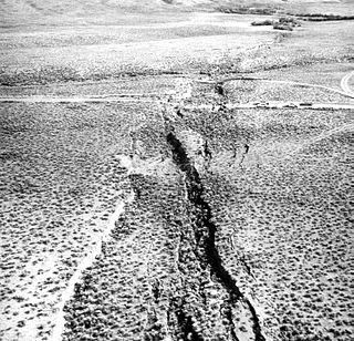
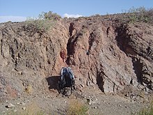
In seismology, surface rupture is the visible offset of the ground surface when an earthquake rupture along a fault affects the Earth's surface. Surface rupture is opposed by buried rupture, where there is no displacement at ground level. This is a major risk to any structure that is built across a fault zone that may be active, in addition to any risk from ground shaking. Surface rupture entails vertical or horizontal movement, on either side of a ruptured fault. Surface rupture can affect large areas of land.

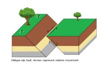
Anderson's theory of faulting, devised by Ernest Masson Anderson in 1905, is a way of classifying geological faults by use of principal stress. A fault is a fracture in the surface of the Earth that occurs when rocks break under extreme stress. Movement of rock along the fracture occurs in faults. If no movement occurs, the fracture is described instead as a joint. The grinding of two rock masses against each another along a fault results in an earthquake and deformation of the Earth's crust. Faults can be classified into four types based on the kind of motion between the separated rock masses: normal, reverse, strike-slip, and oblique.

References

  1. Lutgens, Frederick K.; Tarbuck, E.J.; Tasa, D. (illustrator) (2012). Essentials of geology (11th ed.). Boston: Prentice Hall. p. 32. ISBN   978-0321714725.
  2. 1 2 Ohnaka, M. (2013). The Physics of Rock Failure and Earthquakes. Cambridge University Press. ISBN   978-1-107-35533-0.
  3. USGS, Earthquake Glossary – fault trace , retrieved 10 April 2015
  4. USGS, Robert Tristram (30 April 2003), Where are the Fault Lines in the United States East of the Rocky Mountains?, archived from the original on 18 November 2009, retrieved 6 March 2010
  5. |“Fault zone.” Merriam-Webster.com Dictionary, Merriam-Webster. Retrieved 8 Oct. 2020.
  6. Fillmore, Robert (2010). Geological evolution of the Colorado Plateau of eastern Utah and western Colorado, including the San Juan River, Natural Bridges, Canyonlands, Arches, and the Book Cliffs. Salt Lake City: University of Utah Press. p. 337. ISBN   9781607810049.
  7. Caine, Jonathan Saul; Evans, James P.; Forster, Craig B. (1 November 1996). "Fault zone architecture and permeability structure". Geology. 24 (11): 1025–1028. Bibcode:1996Geo....24.1025S. doi:10.1130/0091-7613(1996)024<1025:FZAAPS>2.3.CO;2.
  8. Childs, Conrad; Manzocchi, Tom; Walsh, John J.; Bonson, Christopher G.; Nicol, Andrew; Schöpfer, Martin P.J. (February 2009). "A geometric model of fault zone and fault rock thickness variations". Journal of Structural Geology. 31 (2): 117–127. Bibcode:2009JSG....31..117C. doi:10.1016/j.jsg.2008.08.009.
  9. Fossen, Haakon (2016). Structural geology (Second ed.). Cambridge, United Kingdom. pp. 117, 178. ISBN   9781107057647.{{cite book}}: CS1 maint: location missing publisher (link)
  10. SCEC & Education Module , p. 14.
  11. "Faults: Introduction". University of California, Santa Cruz. Archived from the original on 27 September 2011. Retrieved 19 March 2010.
  12. Choi, Pom-yong; Lee, Seung Ryeol; Choi, Hyen -Il; Hwang, Jae-ha; Kwon, Seok-ki; Ko, In-sae; An, Gi-o (June 2002). "Movement history of the Andong Fault System: Geometric and tectonic approaches". Geosciences Journal. 6 (2): 91–102. Bibcode:2002GescJ...6...91C. doi:10.1007/BF03028280. S2CID   206832817.
  13. Fossen 2016, p. 479.
  14. USGS, Hanging wall Foot wall, archived from the original on 8 May 2009, retrieved 2 April 2010
  15. Tingley, J.V.; Pizarro, K.A. (2000), Traveling America's loneliest road: a geologic and natural history tour, Nevada Bureau of Mines and Geology Special Publication, vol. 26, Nevada Bureau of Mines and Geology, p. 132, ISBN   978-1-888035-05-6 , retrieved 2 April 2010
  16. "What is a fault and what are the different types?". USGS: Science for a Changing World. Retrieved 13 October 2021.
  17. Allaby, Michael, ed. (2015). "Strike-Slip Fault". A Dictionary of Geology and Earth Sciences (4th ed.). Oxford University Press. ISBN   978-0-19-965306-5.
  18. Park, R.G. (2004). Foundation of Structural Geology (3 ed.). Routledge. p. 11. ISBN   978-0-7487-5802-9.
  19. Oskin, Michael E. (3 June 2019). "Normal Faults". LibreTexts. Retrieved 6 April 2022.
  20. Peacock, D. C. P.; Knipe, R. J.; Sanderson, D. J. (2000). "Glossary of normal faults". Journal of Structural Geology. 22 (3): 298. Bibcode:2000JSG....22..291P. doi:10.1016/S0191-8141(00)80102-9.
  21. "dip slip". Earthquake Glossary. USGS. Archived from the original on 23 November 2017. Retrieved 13 December 2017.
  22. "How are reverse faults different than thrust faults? In what way are they similar?". UCSB Science Line. University of California, Santa Barbara. 13 February 2012. Archived from the original on 27 October 2017. Retrieved 13 December 2017.
  23. Park, R.G. (2004). Foundation of Structural Geology (3 ed.). Routledge. p. 15. ISBN   978-0-7487-5802-9.
  24. 1 2 "Structural Geology Notebook – Caldera Faults". maps.unomaha.edu. Archived from the original on 19 November 2018. Retrieved 6 April 2018.
  25. Jin-Hyuck, Choi; Paul, Edwards; Kyoungtae, Ko; Kim, Young-Seog (January 2016). "Definition and classification of fault damage zones: A review and a new methodological approach". Earth-Science Reviews. 152: 70-87. doi:10.1016/j.earscirev.2015.11.006.
  26. Rowe, Christie; Griffith, Ashley (2015). "Do faults preserve a record of seismic slip: A second opinion". Journal of Structural Geology. 78: 1–26. Bibcode:2015JSG....78....1R. doi:10.1016/j.jsg.2015.06.006.
  27. Brodie, Kate; Fettes, Douglas; Harte, Ben; Schmid, Rolf (29 January 2007), Structural terms including fault rock terms, International Union of Geological Sciences
  28. Troll, V R; Mattsson, T; Upton, B G J; Emeleus, C H; Donaldson, C H; Meyer, R; Weis, F; Dahrén, B; Heimdal, T H (9 October 2020). "Fault-Controlled Magma Ascent Recorded in the Central Series of the Rum Layered Intrusion, NW Scotland". Journal of Petrology. 61 (10). doi: 10.1093/petrology/egaa093 . hdl: 10023/23208 . ISSN   0022-3530.
  29. 1 2 Piquer Romo, José Meulen; Yáñez, Gonzálo; Rivera, Orlando; Cooke, David (2019). "Long-lived crustal damage zones associated with fault intersections in the high Andes of Central Chile". Andean Geology . 46 (2): 223–239. doi: 10.5027/andgeoV46n2-3108 . Archived from the original on 8 August 2019. Retrieved 9 June 2019.
  30. Robb, Laurence (2007). Introduction to Ore-Forming Processes (4th ed.). Malden, MA, United States: Blackwell Science Ltd. p. 104. ISBN   978-0-632-06378-9.
  31. 1 2 Piquer, José; Sanchez-Alfaro, Pablo; Pérez-Flores, Pamela (2021). "A new model for the optimal structural context for giant porphyry copper deposit formation". Geology . 49 (5): 597–601. Bibcode:2021Geo....49..597P. doi: 10.1130/G48287.1 . S2CID   234008062.
  32. Pradhan, Rudra Mohan; Singh, Anand; Ojha, Arun Kumar; Biswal, Tapas Kumar (12 July 2022). "Structural controls on bedrock weathering in crystalline basement terranes and its implications on groundwater resources". Scientific Reports. 12 (1): 11815. Bibcode:2022NatSR..1211815P. doi:10.1038/s41598-022-15889-x. ISSN   2045-2322. PMC   9276672 . PMID   35821387.

Other reading