Rift

Last updated
Block view of a rift formed of three segments, showing the location of the accommodation zones between them at changes in fault location or polarity (dip direction) Rift segmentation.png
Block view of a rift formed of three segments, showing the location of the accommodation zones between them at changes in fault location or polarity (dip direction)
Gulf of Suez Rift showing main extensional faults GulfofSuezRift.png
Gulf of Suez Rift showing main extensional faults

In geology, a rift is a linear zone where the lithosphere is being pulled apart [1] [2] and is an example of extensional tectonics. [3] Typical rift features are a central linear downfaulted depression, called a graben, or more commonly a half-graben with normal faulting and rift-flank uplifts mainly on one side. [4] Where rifts remain above sea level they form a rift valley, which may be filled by water forming a rift lake. The axis of the rift area may contain volcanic rocks, and active volcanism is a part of many, but not all, active rift systems.

Contents

Major rifts occur along the central axis of most mid-ocean ridges, where new oceanic crust and lithosphere is created along a divergent boundary between two tectonic plates.

Failed rifts are the result of continental rifting that failed to continue to the point of break-up. Typically the transition from rifting to spreading develops at a triple junction where three converging rifts meet over a hotspot. Two of these evolve to the point of seafloor spreading, while the third ultimately fails, becoming an aulacogen.

Geometry

Topographic profile of the Malawi Lake FlankMalawi.png
Topographic profile of the Malawi Lake

Most rifts consist of a series of separate segments that together form the linear zone characteristic of rifts. The individual rift segments have a dominantly half-graben geometry, controlled by a single basin-bounding fault. Segment lengths vary between rifts, depending on the elastic thickness of the lithosphere. Areas of thick colder lithosphere, such as the Baikal Rift have segment lengths in excess of 80 km, while in areas of warmer thin lithosphere, segment lengths may be less than 30 km. [5] Along the axis of the rift the position, and in some cases the polarity (the dip direction), of the main rift bounding fault changes from segment to segment. Segment boundaries often have a more complex structure and generally cross the rift axis at a high angle. These segment boundary zones accommodate the differences in fault displacement between the segments and are therefore known as accommodation zones.

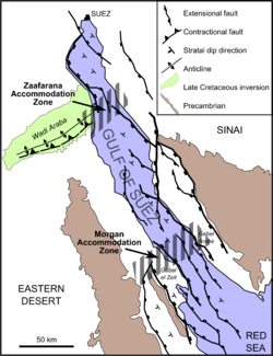
Accommodation zones take various forms, from a simple relay ramp at the overlap between two major faults of the same polarity, to zones of high structural complexity, particularly where the segments have opposite polarity. Accommodation zones may be located where older crustal structures intersect the rift axis. In the Gulf of Suez rift, the Zaafarana accommodation zone is located where a shear zone in the Arabian-Nubian Shield meets the rift. [6]

Rift flanks or shoulders are elevated areas around rifts. Rift shoulders are typically about 70 km wide. [7] Contrary to what was previously thought, elevated passive continental margins (EPCM) such as the Brazilian Highlands, the Scandinavian Mountains and India's Western Ghats, are not rift shoulders. [7]

Rift development

Rift initiation

The formation of rift basins and strain localization reflects rift maturity. At the onset of rifting, the upper part of the lithosphere starts to extend on a series of initially unconnected normal faults, leading to the development of isolated basins. [8] In subaerial rifts, for example, drainage at the onset of rifting is generally internal, with no element of through drainage.

Mature rift stage

As the rift evolves, some of the individual fault segments grow, eventually becoming linked together to form the larger bounding faults. Subsequent extension becomes concentrated on these faults. The longer faults and wider fault spacing leads to more continuous areas of fault-related subsidence along the rift axis. Significant uplift of the rift shoulders develops at this stage, strongly influencing drainage and sedimentation in the rift basins. [8]

During the climax of lithospheric rifting, as the crust is thinned, the Earth's surface subsides and the Moho becomes correspondingly raised. At the same time, the mantle lithosphere becomes thinned, causing a rise of the top of the asthenosphere. This brings high heat flow from the upwelling asthenosphere into the thinning lithosphere, heating the orogenic lithosphere for dehydration melting, typically causing extreme metamorphism at high thermal gradients of greater than 30 °C. The metamorphic products are high to ultrahigh temperature granulites and their associated migmatite and granites in collisional orogens, with possible emplacement of metamorphic core complexes in continental rift zones but oceanic core complexes in spreading ridges. This leads to a kind of orogeneses in extensional settings, which is referred as to rifting orogeny. [9]

Post-rift subsidence

Once rifting ceases, the mantle beneath the rift cools and this is accompanied by a broad area of post-rift subsidence. The amount of subsidence is directly related to the amount of thinning during the rifting phase calculated as the beta factor (initial crustal thickness divided by final crustal thickness), but is also affected by the degree to which the rift basin is filled at each stage, due to the greater density of sediments in contrast to water. The simple 'McKenzie model' of rifting, which considers the rifting stage to be instantaneous, provides a good first order estimate of the amount of crustal thinning from observations of the amount of post-rift subsidence. [10] [11] This has generally been replaced by the 'flexural cantilever model', which takes into account the geometry of the rift faults and the flexural isostasy of the upper part of the crust. [12]

Multiphase rifting

Some rifts show a complex and prolonged history of rifting, with several distinct phases. The North Sea rift shows evidence of several separate rift phases from the Permian through to the Earliest Cretaceous, [13] a period of over 100 million years.

Rifting to break-up

Rifting may lead to continental breakup and formation of oceanic basins. Successful rifting leads to seafloor spreading along a mid-oceanic ridge and a set of conjugate margins separated by an oceanic basin. [14] Rifting may be active, and controlled by mantle convection. It may also be passive, and driven by far-field tectonic forces that stretch the lithosphere. Margin architecture develops due to spatial and temporal relationships between extensional deformation phases. Margin segmentation eventually leads to the formation of rift domains with variations of the Moho topography, including proximal domain with fault-rotated crustal blocks, necking zone with thinning of crustal basement, distal domain with deep sag basins, ocean-continent transition and oceanic domain. [15]

Deformation and magmatism interact during rift evolution. Magma-rich and magma-poor rifted margins may be formed. [15] Magma-rich margins include major volcanic features. Globally, volcanic margins represent the majority of passive continental margins. [16] Magma-starved rifted margins are affected by large-scale faulting and crustal hyperextension. [17] As a consequence, upper mantle peridotites and gabbros are commonly exposed and serpentinized along extensional detachments at the seafloor.

Magmatism

Volcano-tectonic landforms connected to rifting on Reykjanes Peninsula, Iceland: faults, fissures, elongated volcanoes of subglacial origin, postglacial lava fields 20190621 CPH-KEF 7314 (48453477346).jpg
Volcano-tectonic landforms connected to rifting on Reykjanes Peninsula, Iceland: faults, fissures, elongated volcanoes of subglacial origin, postglacial lava fields

Many rifts are the sites of at least minor magmatic activity, particularly in the early stages of rifting. [18] Alkali basalts and bimodal volcanism are common products of rift-related magmatism. [19] [20]

Recent studies indicate that post-collisional granites in collisional orogens are the product of rifting magmatism at converged plate margins.[ citation needed ]

Economic importance

The sedimentary rocks associated with continental rifts host important deposits of both minerals and hydrocarbons. [21]

Mineral deposits

SedEx mineral deposits are found mainly in continental rift settings. They form within post-rift sequences when hydrothermal fluids associated with magmatic activity are expelled at the seabed. [22]

Oil and gas

Continental rifts are the sites of significant oil and gas accumulations, such as the Viking Graben and the Gulf of Suez Rift. Thirty percent of giant oil and gas fields are found within such a setting. [23] In 1999 it was estimated that there were 200 billion barrels of recoverable oil reserves hosted in rifts. Source rocks are often developed within the sediments filling the active rift (syn-rift), forming either in a lacustrine environment or in a restricted marine environment, although not all rifts contain such sequences. Reservoir rocks may be developed in pre-rift, syn-rift and post-rift sequences. Effective regional seals may be present within the post-rift sequence if mudstones or evaporites are deposited. Just over half of estimated oil reserves are found associated with rifts containing marine syn-rift and post-rift sequences, just under a quarter in rifts with a non-marine syn-rift and post-rift, and an eighth in non-marine syn-rift with a marine post-rift. [24]

Examples

See also

Related Research Articles

<span class="mw-page-title-main">Rio Grande rift</span> Continental rift zone in the southwest United States

The Rio Grande rift is a north-trending continental rift zone. It separates the Colorado Plateau in the west from the interior of the North American craton on the east. The rift extends from central Colorado in the north to the state of Chihuahua, Mexico, in the south. The rift zone consists of four basins that have an average width of 50 kilometres (31 mi). The rift can be observed on location at Rio Grande National Forest, White Sands National Park, Santa Fe National Forest, and Cibola National Forest, among other locations.

<span class="mw-page-title-main">Sedimentary basin</span> Regions of long-term subsidence creating space for infilling by sediments

Sedimentary basins are region-scale depressions of the Earth's crust where subsidence has occurred and a thick sequence of sediments have accumulated to form a large three-dimensional body of sedimentary rock. They form when long-term subsidence creates a regional depression that provides accommodation space for accumulation of sediments. Over millions or tens or hundreds of millions of years the deposition of sediment, primarily gravity-driven transportation of water-borne eroded material, acts to fill the depression. As the sediments are buried, they are subject to increasing pressure and begin the processes of compaction and lithification that transform them into sedimentary rock.

<span class="mw-page-title-main">Mountain formation</span> Geological processes that underlie the formation of mountains

Mountain formation refers to the geological processes that underlie the formation of mountains. These processes are associated with large-scale movements of the Earth's crust. Folding, faulting, volcanic activity, igneous intrusion and metamorphism can all be parts of the orogenic process of mountain building. The formation of mountains is not necessarily related to the geological structures found on it.

<span class="mw-page-title-main">East African Rift</span> Active continental rift zone in East Africa

The East African Rift (EAR) or East African Rift System (EARS) is an active continental rift zone in East Africa. The EAR began developing around the onset of the Miocene, 22–25 million years ago. It was formerly considered to be part of a larger Great Rift Valley that extended north to Asia Minor.

<span class="mw-page-title-main">Passive margin</span> Transition between oceanic and continental lithosphere that is not an active plate margin

A passive margin is the transition between oceanic and continental lithosphere that is not an active plate margin. A passive margin forms by sedimentation above an ancient rift, now marked by transitional lithosphere. Continental rifting forms new ocean basins. Eventually the continental rift forms a mid-ocean ridge and the locus of extension moves away from the continent-ocean boundary. The transition between the continental and oceanic lithosphere that was originally formed by rifting is known as a passive margin.

<span class="mw-page-title-main">Northern Cordilleran Volcanic Province</span> Geologic province in the Pacific Northwest of North America

The Northern Cordilleran Volcanic Province (NCVP), formerly known as the Stikine Volcanic Belt, is a geologic province defined by the occurrence of Miocene to Holocene volcanoes in the Pacific Northwest of North America. This belt of volcanoes extends roughly north-northwest from northwestern British Columbia and the Alaska Panhandle through Yukon to the Southeast Fairbanks Census Area of far eastern Alaska, in a corridor hundreds of kilometres wide. It is the most recently defined volcanic province in the Western Cordillera. It has formed due to extensional cracking of the North American continent—similar to other on-land extensional volcanic zones, including the Basin and Range Province and the East African Rift. Although taking its name from the Western Cordillera, this term is a geologic grouping rather than a geographic one. The southmost part of the NCVP has more, and larger, volcanoes than does the rest of the NCVP; further north it is less clearly delineated, describing a large arch that sways westward through central Yukon.

Extensional tectonics is concerned with the structures formed by, and the tectonic processes associated with, the stretching of a planetary body's crust or lithosphere.

<span class="mw-page-title-main">Afar Triple Junction</span> Place where three tectonic rifts meet in East Africa

The Afar Triple Junction is located along a divergent plate boundary dividing the Nubian, Somali, and Arabian plates. This area is considered a present-day example of continental rifting leading to seafloor spreading and producing an oceanic basin. Here, the Red Sea Rift meets the Aden Ridge and the East African Rift. The latter extends a total of 6,500 kilometers (4,000 mi) from the Afar Triangle to Mozambique.

Non-volcanic passive margins (NVPM) constitute one end member of the transitional crustal types that lie beneath passive continental margins; the other end member being volcanic passive margins (VPM). Transitional crust welds continental crust to oceanic crust along the lines of continental break-up. Both VPM and NVPM form during rifting, when a continent rifts to form a new ocean basin. NVPM are different from VPM because of a lack of volcanism. Instead of intrusive magmatic structures, the transitional crust is composed of stretched continental crust and exhumed upper mantle. NVPM are typically submerged and buried beneath thick sediments, so they must be studied using geophysical techniques or drilling. NVPM have diagnostic seismic, gravity, and magnetic characteristics that can be used to distinguish them from VPM and for demarcating the transition between continental and oceanic crust.

Volcanic passive margins (VPM) and non-volcanic passive margins are the two forms of transitional crust that lie beneath passive continental margins that occur on Earth as the result of the formation of ocean basins via continental rifting. Initiation of igneous processes associated with volcanic passive margins occurs before and/or during the rifting process depending on the cause of rifting. There are two accepted models for VPM formation: hotspots/mantle plumes and slab pull. Both result in large, quick lava flows over a relatively short period of geologic time. VPM's progress further as cooling and subsidence begins as the margins give way to formation of normal oceanic crust from the widening rifts.

Tectonic subsidence is the sinking of the Earth's crust on a large scale, relative to crustal-scale features or the geoid. The movement of crustal plates and accommodation spaces produced by faulting brought about subsidence on a large scale in a variety of environments, including passive margins, aulacogens, fore-arc basins, foreland basins, intercontinental basins and pull-apart basins. Three mechanisms are common in the tectonic environments in which subsidence occurs: extension, cooling and loading.

<span class="mw-page-title-main">Half-graben</span> Geological structure bounded by a fault along one side of its boundaries

A half-graben is a geological structure bounded by a fault along one side of its boundaries, unlike a full graben where a depressed block of land is bordered by parallel faults.

The South China Sea Basin is one of the largest marginal basins in Asia. South China Sea is located to the east of Vietnam, west of Philippines and the Luzon Strait, and north of Borneo. Tectonically, it is surrounded by the Indochina Block on the west, Philippine Sea Plate on the east, Yangtze Block to the north. A subduction boundary exists between the Philippine Sea Plate and the Asian Plate. The formation of the South China Sea Basin was closely related with the collision between the Indian Plate and Eurasian Plates. The collision thickened the continental crust and changed the elevation of the topography from the Himalayan orogenic zone to the South China Sea, especially around the Tibetan Plateau. The location of the South China Sea makes it a product of several tectonic events. All the plates around the South China Sea Basin underwent clockwise rotation, subduction and experienced an extrusion process from the early Cenozoic to the Late Miocene.

<span class="mw-page-title-main">Northern North Sea basin</span>

The North Sea is part of the Atlantic Ocean in northern Europe. It is located between Norway and Denmark in the east, Scotland and England in the west, Germany, the Netherlands, Belgium and France in the south.

The Tyrrhenian Basin is a sedimentary basin located in the western Mediterranean Sea under the Tyrrhenian Sea. It covers a 231,000 km2 area that is bounded by Sardinia to the west, Corsica to the northwest, Sicily to the southeast, and peninsular Italy to the northeast. The Tyrrhenian basin displays an irregular seafloor marked by several seamounts and two distinct sub-basins - the Vavilov and Marsili basins. The Vavilov deep plain contains the deepest point of the Tyrrhenian basin at approximately 3785 meters. The basin trends roughly northwest–southeast with the spreading axis trending northeast–southwest.

<span class="mw-page-title-main">Kutai Basin</span>

The Kutai sedimentary basin extends from the central highlands of Borneo, across the eastern coast of the island and into the Makassar Strait. With an area of 60,000 km2, and depths up to 15 km, the Kutai is the largest and deepest Tertiary age basin in Indonesia. Plate tectonic evolution in the Indonesian region of SE Asia has produced a diverse array of basins in the Cenozoic. The Kutai is an extensional basin in a general foreland setting. Its geologic evolution begins in the mid Eocene and involves phases of extension and rifting, thermal sag, and isostatic subsidence. Rapid, high volume, sedimentation related to uplift and inversion began in the Early Miocene. The different stages of Kutai basin evolution can be roughly correlated to regional and local tectonic events. It is also likely that regional climate, namely the onset of the equatorial ever wet monsoon in early Miocene, has affected the geologic evolution of Borneo and the Kutai basin through the present day. Basin fill is ongoing in the lower Kutai basin, as the modern Mahakam River delta progrades east across the continental shelf of Borneo.

<span class="mw-page-title-main">Geological history of Borneo</span>

The base of rocks that underlie Borneo, an island in Southeast Asia, was formed by the arc-continent collisions, continent–continent collisions and subduction–accretion due to convergence between the Asian, India–Australia, and Philippine Sea-Pacific plates over the last 400 million years. The active geological processes of Borneo are mild as all of the volcanoes are extinct. The geological forces shaping SE Asia today are from three plate boundaries: the collisional zone in Sulawesi southeast of Borneo, the Java-Sumatra subduction boundary and the India-Eurasia continental collision.

<span class="mw-page-title-main">Huangling Anticline</span>

The Huangling Anticline or Complex represents a group of rock units that appear in the middle of the Yangtze Block in South China, distributed across Yixingshan, Zigui, Huangling, and Yichang counties. The group of rock involves nonconformity that sedimentary rocks overlie the metamorphic basement. It is a 73-km long, asymmetrical dome-shaped anticline with axial plane orientating in the north-south direction. It has a steeper west flank and a gentler east flank. Basically, there are three tectonic units from the anticline core to the rim, including Archean to Paleoproterozoic metamorphic basement, Neoproterozoic to Jurassic sedimentary rocks, and Cretaceous fluvial deposit sedimentary cover. The northern part of the core is mainly tonalite-trondhjemite-gneiss (TTG) and Cretaceous sedimentary rock called the Archean Kongling Complex. The middle of the core is mainly the Neoproterozoic granitoid. The southern part of the core is the Neoproterozoic potassium granite. Two basins are situated on the western and eastern flanks of the core, respectively, including the Zigui basin and Dangyang basin. Both basins are synforms while Zigui basin has a larger extent of folding. Yuanan Graben and Jingmen Graben are found within the Dangyang Basin area. The Huangling Anticline is an important area that helps unravel the tectonic history of the South China Craton because it has well-exposed layers of rock units from Archean basement rock to Cretaceous sedimentary rock cover due to the erosion of the anticline.

<span class="mw-page-title-main">Plate theory (volcanism)</span>

The plate theory is a model of volcanism that attributes all volcanic activity on Earth, even that which appears superficially to be anomalous, to the operation of plate tectonics. According to the plate theory, the principal cause of volcanism is extension of the lithosphere. Extension of the lithosphere is a function of the lithospheric stress field. The global distribution of volcanic activity at a given time reflects the contemporaneous lithospheric stress field, and changes in the spatial and temporal distribution of volcanoes reflect changes in the stress field. The main factors governing the evolution of the stress field are:

  1. Changes in the configuration of plate boundaries.
  2. Vertical motions.
  3. Thermal contraction.

Magmatism along strike-slip faults is the process of rock melting, magma ascent and emplacement, associated with the tectonics and geometry of various strike-slip settings, most commonly occurring along transform boundaries at mid-ocean ridge spreading centres and at strike-slip systems parallel to oblique subduction zones. Strike-slip faults have a direct effect on magmatism. They can either induce magmatism, act as a conduit to magmatism and magmatic flow, or block magmatic flow. In contrast, magmatism can also directly impact on strike-slip faults by determining fault formation, propagation and slip. Both magma and strike-slip faults coexist and affect one another.

References

  1. Rift valley: definition and geologic significance, Giacomo Corti, The Ethiopian Rift Valley
  2. Decompressional Melting During Extension of Continental Lithosphere, Jolante van Wijk, MantlePlumes.org
  3. Plate Tectonics: Lecture 2, Geology Department at University of Leicester
  4. Leeder, M.R.; Gawthorpe, R.L. (1987). "Sedimentary models for extensional tilt-block/half-graben basins" (PDF). In Coward, M.P.; Dewey, J.F.; Hancock, P.L. (eds.). Continental Extensional Tectonics. Geological Society, Special Publications. Vol. 28. pp. 139–152. ISBN   9780632016051.
  5. Ebinger, C.J.; Jackson J.A.; Foster A.N.; Hayward N.J. (1999). "Extensional basin geometry and the elastic lithosphere". Philosophical Transactions of the Royal Society A . 357 (1753): 741–765. Bibcode:1999RSPTA.357..741E. doi:10.1098/rsta.1999.0351. S2CID   91719117.
  6. Younes, A.I.; McClay K. (2002). "Development of Accommodation Zones in the Gulf of Suez-Red Sea Rift, Egypt". AAPG Bulletin. 86 (6): 1003–1026. doi:10.1306/61EEDC10-173E-11D7-8645000102C1865D . Retrieved 29 October 2012.
  7. 1 2 Green, Paul F.; Japsen, Peter; Chalmers, James A.; Bonow, Johan M.; Duddy, Ian R. (2018). "Post-breakup burial and exhumation of passive continental margins: Seven propositions to inform geodynamic models". Gondwana Research . 53: 58–81. Bibcode:2018GondR..53...58G. doi:10.1016/j.gr.2017.03.007.
  8. 1 2 Withjack, M.O.; Schlische R.W.; Olsen P.E. (2002). "Rift-basin structure and its influence on sedimentary systems" (PDF). In Renaut R.W. & Ashley G.M. (ed.). Sedimentation in Continental Rifts. Special Publications. Vol. 73. Society for Sedimentary Geology. Retrieved 28 October 2012.
  9. Zheng, Y.-F.; Chen, R.-X. (2017). "Regional metamorphism at extreme conditions: Implications for orogeny at convergent plate margins". Journal of Asian Earth Sciences. 145: 46–73. Bibcode:2017JAESc.145...46Z. doi: 10.1016/j.jseaes.2017.03.009 .
  10. McKenzie, D. (1978). "Some remarks on the development of sedimentary basins" (PDF). Earth and Planetary Science Letters. 40 (1): 25–32. Bibcode:1978E&PSL..40...25M. CiteSeerX   10.1.1.459.4779 . doi:10.1016/0012-821x(78)90071-7. Archived from the original (PDF) on 1 March 2014. Retrieved 25 October 2012.
  11. Kusznir, N.J.; Roberts A.M.; Morley C.K. (1995). "Forward and reverse modelling of rift basin formation". In Lambiase J.J. (ed.). Hydrocarbon habitat in rift basins. Special Publications. Vol. 80. London: Geological Society. pp. 33–56. ISBN   9781897799154 . Retrieved 25 October 2012.
  12. Nøttvedt, A.; Gabrielsen R.H.; Steel R.J. (1995). "Tectonostratigraphy and sedimentary architecture of rift basins, with reference to the northern North Sea". Marine and Petroleum Geology . 12 (8): 881–901. Bibcode:1995MarPG..12..881N. doi:10.1016/0264-8172(95)98853-W.
  13. Ravnås, R.; Nøttvedt A.; Steel R.J.; Windelstad J. (2000). "Syn-rift sedimentary architectures in the Northern North Sea". Dynamics of the Norwegian Margin. Special Publications. Vol. 167. London: Geological Society. pp. 133–177. ISBN   9781862390560 . Retrieved 28 October 2012.
  14. Ziegler P.A.; Cloetingh S. (January 2004). "Dynamic processes controlling evolution of rifted basins". Earth-Science Reviews. 64 (1–2): 1–50. Bibcode:2004ESRv...64....1Z. doi:10.1016/S0012-8252(03)00041-2.
  15. 1 2 Péron-Pinvidic G.; Manatschal G.; Osmundsen P.T. (May 2013). "Structural comparison of archetypal Atlantic rifted margins: a review of observations and concepts". Marine and Petroleum Geology. 43: 21–47. Bibcode:2013MarPG..43...21P. doi:10.1016/j.marpetgeo.2013.02.002.
  16. Reston T.J.; Manatschal G. (2011). "Arc-Continent Collision". In Brown D. & Ryan P.D. (ed.). Building blocks of later collision. Frontiers in Earth Sciences.
  17. Péron-Pinvidic G.; Manatschal G. (2009). "The final rifting evolution at deep magma-poor passive margins from Iberia-Newfoundland: a new point of view". International Journal of Earth Sciences. 98 (7): 1581. Bibcode:2009IJEaS..98.1581P. doi:10.1007/s00531-008-0337-9. S2CID   129442856.
  18. White, R.S.; McKenzie D. (1989). "Magmatism at Rift Zones: The Generation of Volcanic Margins and Flood Basalts" (PDF). Journal of Geophysical Research. 94 (B6): 7685–7729. Bibcode:1989JGR....94.7685W. doi:10.1029/jb094ib06p07685 . Retrieved 27 October 2012.
  19. Farmer, G.L. (2005). "Continental Basaltic Rocks". In Rudnick R.L. (ed.). Treatise on Geochemistry: The crust. Gulf Professional Publishing. p. 97. ISBN   9780080448473 . Retrieved 28 October 2012.
  20. Cas, R.A.F. (2005). "Volcanoes and the geological cycle". In Marti J. & Ernst G.G. (ed.). Volcanoes and the Environment. Cambridge University Press. p. 145. ISBN   9781139445108 . Retrieved 28 October 2012.
  21. United States Geological Survey (1993). "Lake Baikal - A Touchstone for Global Change and Rift Studies". Archived from the original on 29 June 2012. Retrieved 28 October 2012.
  22. Groves, D.I.; Bierlein F.P. (2007). "Geodynamic settings of mineral deposit systems". Journal of the Geological Society. 164 (1): 19–30. Bibcode:2007JGSoc.164...19G. doi:10.1144/0016-76492006-065. S2CID   129680970 . Retrieved 27 October 2012.
  23. Mann, P.; Gahagan L.; Gordon M.B. (2001). "Tectonic setting of the world's giant oil fields". WorldOil Magazine. Retrieved 27 October 2012.
  24. Lambiase, J.J.; Morley C.K. (1999). "Hydrocarbons in rift basins: the role of stratigraphy". Philosophical Transactions of the Royal Society A . 357 (1753): 877–900. Bibcode:1999RSPTA.357..877L. CiteSeerX   10.1.1.892.6422 . doi:10.1098/rsta.1999.0356. S2CID   129564482.
  25. Chouhan, A.K. Structural fabric over the seismically active Kachchh rift basin, India: insight from world gravity model 2012. Environ Earth Sci 79, 316 (2020). https://doi.org/10.1007/s12665-020-09068-2
  26. Chouhan, A.K., Choudhury, P. & Pal, S.K. New evidence for a thin crust and magmatic underplating beneath the Cambay rift basin, Western India through modelling of EIGEN-6C4 gravity data. J Earth Syst Sci 129, 64 (2020). https://doi.org/10.1007/s12040-019-1335-y

Further reading