


A monocline (or, rarely, a monoform) is a step-like fold in rock strata consisting of a zone of steeper dip within an otherwise horizontal or gently dipping sequence.
A monocline (or, rarely, a monoform) is a step-like fold in rock strata consisting of a zone of steeper dip within an otherwise horizontal or gently dipping sequence.

Monoclines may be formed in several different ways (see diagram)

A thrust fault is a break in the Earth's crust, across which older rocks are pushed above younger rocks.

In structural geology, a fold is a stack of originally planar surfaces, such as sedimentary strata, that are bent or curved ("folded") during permanent deformation. Folds in rocks vary in size from microscopic crinkles to mountain-sized folds. They occur as single isolated folds or in periodic sets. Synsedimentary folds are those formed during sedimentary deposition.

Mylonite is a fine-grained, compact metamorphic rock produced by dynamic recrystallization of the constituent minerals resulting in a reduction of the grain size of the rock. Mylonites can have many different mineralogical compositions; it is a classification based on the textural appearance of the rock.
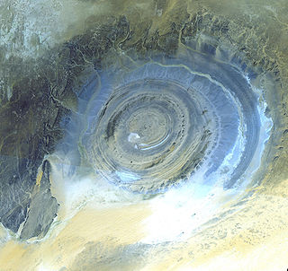
A dome is a feature in structural geology where a circular part of the Earth's surface has been pushed upward, tilting the pre-existing layers of earth away from the center. In technical terms, it consists of symmetrical anticlines that intersect each other at their respective apices. Intact, domes are distinct, rounded, spherical-to-ellipsoidal-shaped protrusions on the Earth's surface. A slice parallel to Earth's surface of a dome features concentric rings of strata. If the top of a dome has been eroded flat, the resulting structure in plan view appears as a bullseye, with the youngest rock layers at the outside, and each ring growing progressively older moving inwards. These strata would have been horizontal at the time of deposition, then later deformed by the uplift associated with dome formation.

The Moab Fault, near Moab, Utah, United States, is an extensional fault that runs approximately NW-SE, passing to the west of the Arches National Park. It is about 45 km (28 mi) long and has a maximum displacement of about 960 m (3,150 ft). The fault connects with the Tenmile graben in the north and extends through the Moab-Spanish Valley to the south. The fault outcrop has a well-defined fault zone bordered by a damage zone of minor faults and fractures.

In geology, transpression is a type of strike-slip deformation that deviates from simple shear because of a simultaneous component of shortening perpendicular to the fault plane. This movement ends up resulting in oblique shear. It is generally very unlikely that a deforming body will experience "pure" shortening or "pure" strike-slip. The relative amounts of shortening and strike-slip can be expressed in the convergence angle alpha which ranges from zero to 90 degrees. During shortening, unless material is lost, transpression produces vertical thickening in the crust. Transpression that occurs on a regional scale along plate boundaries is characterized by oblique convergence. More locally, transpression occurs within restraining bends in strike-slip fault zones.
Strike-slip tectonics or wrench tectonics is a type of tectonics that is dominated by lateral (horizontal) movements within the Earth's crust. Where a zone of strike-slip tectonics forms the boundary between two tectonic plates, this is known as a transform or conservative plate boundary. Areas of strike-slip tectonics are characterised by particular deformation styles including: stepovers, Riedel shears, flower structures and strike-slip duplexes. Where the displacement along a zone of strike-slip deviates from parallelism with the zone itself, the style becomes either transpressional or transtensional depending on the sense of deviation. Strike-slip tectonics is characteristic of several geological environments, including oceanic and continental transform faults, zones of oblique collision and the deforming foreland of zones of continental collision.

Salt tectonics, or halokinesis, or halotectonics, is concerned with the geometries and processes associated with the presence of significant thicknesses of evaporites containing rock salt within a stratigraphic sequence of rocks. This is due both to the low density of salt, which does not increase with burial, and its low strength.
In structural geology and diagenesis, pressure solution or pressure dissolution is a deformation mechanism that involves the dissolution of minerals at grain-to-grain contacts into an aqueous pore fluid in areas of relatively high stress and either deposition in regions of relatively low stress within the same rock or their complete removal from the rock within the fluid. It is an example of diffusive mass transfer.

In structural geology, a homocline or homoclinal structure, is a geological structure in which the layers of a sequence of rock strata, either sedimentary or igneous, dip uniformly in a single direction having the same general inclination in terms of direction and angle. A homocline can be associated with either one limb of a fold, the edges of a dome, the coast-ward tilted strata underlying a coastal plain, slice of thrust fault, or a tilted fault block. When the homoclinal strata consists of alternating layers of rock that vary hardness and resistance to erosion, their erosion produces either cuestas, homoclinal ridges, or hogbacks depending on the angle of dip of the strata. On a topographic map, the landfroms associated with homoclines exhibit nearly parallel elevation contour lines that show a steady change in elevation in a given direction. In the subsurface, they characterize by parallel structural contour lines.

In structural geology section restoration or palinspastic restoration is a technique used to progressively undeform a geological section in an attempt to validate the interpretation used to build the section. It is also used to provide insights into the geometry of earlier stages of the geological development of an area. A section that can be successfully undeformed to a geologically reasonable geometry, without change in area, is known as a balanced section.

The geology of Russia, the world's largest country, which extends over much of northern Eurasia, consists of several stable cratons and sedimentary platforms bounded by orogenic (mountain) belts.

The Purbeck Monocline is a geological fold in southern England. The term 'fold' is used in geology when one or more originally flat sedimentary strata surfaces are bent or curved as a result of plastic deformation. A monocline is a step-like fold, in which one limb is roughly horizontal. The Purbeck Monocline was formed during the late Oligocene and early Miocene epochs, about 30 million years ago. It is the northernmost 'ripple' of the Alpine Orogeny.

The Dwyka Group is one of four geological groups that compose the Karoo Supergroup. It is the lowermost geological group and heralds the commencement of sedimentation of the Karoo Supergroup. Based on stratigraphic position, lithostratigraphic correlation and palynological analyses, these lowermost Karoo strata range between the Late Carboniferous (Pennsylvanian) to Early Permian in age.
The Antarctic Peninsula, roughly 1,000 kilometres (650 mi) south of South America, is the northernmost portion of the continent of Antarctica. Like the associated Andes, the Antarctic Peninsula is an excellent example of ocean-continent collision resulting in subduction. The peninsula has experienced continuous subduction for over 200 million years, but changes in continental configurations during the amalgamation and breakup of continents have changed the orientation of the peninsula itself, as well as the underlying volcanic rocks associated with the subduction zone.

The geology of the Isle of Wight is dominated by sedimentary rocks of Cretaceous and Paleogene age. This sequence was affected by the late stages of the Alpine Orogeny, forming the Isle of Wight monocline, the cause of the steeply-dipping outcrops of the Chalk Group and overlying Paleogene strata seen at The Needles, Alum Bay and Whitecliff Bay.
The South Lokichar Basin is a Cenozoic sedimentary basin in Kenya. It is part of the East African Rift system, although it is no longer active. Since 2012 it has been the location of a series of oil discoveries by Tullow Oil and its partners.
One of the major depositional strata in the Himalaya is the Lesser Himalayan Strata from the Paleozoic to Mesozoic eras. It had a quite different marine succession during the Paleozoic, as most parts of it are sparsely fossiliferous or even devoid of any well-defined fossils. Moreover, it consists of many varied lithofacies, making correlation work more difficult. This article describes the major formations of the Paleozoic – Mesozoic Lesser Himalayan Strata, including the Tal Formation, Gondwana Strata, Singtali Formation and Subathu Formation.

The Wessex Basin is a petroleum-bearing geological area located along the southern coast of England and extending into the English Channel. The onshore part of the basin covers approximately 20,000 km2 and the area that encompasses the English Channel is of similar size. The basin is a rift basin that was created during the Permian to early Cretaceous in response to movement of the African plate relative to the Eurasian plate. In the late Cretaceous, and again in the Cenozoic, the basin was inverted as a distant effect of the Alpine orogeny. The basin is usually divided into 3 main sub-basins including the Winterborne-Kingston Trough, Channel Basin, and Vale of Pewsey Basin. The area is also rich in hydrocarbons with several offshore wells in the area. With the large interest in the hydrocarbon exploration of the area, data became more readily available, which improved the understanding of the type of inversion tectonics that characterize this basin.

The Junggar Basin, also known as the Dzungarian Basin or Zungarian Basin, is one of the largest sedimentary basins in Northwest China. It is located in Dzungaria in northern Xinjiang, and enclosed by the Tarbagatai Mountains of Kazakhstan in the northwest, the Altai Mountains of Mongolia in the northeast, and the Heavenly Mountains in the south. The geology of Junggar Basin mainly consists of sedimentary rocks underlain by igneous and metamorphic basement rocks. The basement of the basin was largely formed during the development of the Pangea supercontinent during complex tectonic events from Precambrian to late Paleozoic time. The basin developed as a series of foreland basins – in other words, basins developing immediately in front of growing mountain ranges – from Permian time to the Quaternary period. The basin's preserved sedimentary records show that the climate during the Mesozoic era was marked by a transition from humid to arid conditions as monsoonal climatic effects waned. The Junggar basin is rich in geological resources due to effects of volcanism and sedimentary deposition. According to Guinness World Records it is a land location remotest from open sea with great-circle distance of 2,648 km from the nearest open sea at 46°16′8″N86°40′2″E.