The Llano Uplift is a geologically ancient, low geologic dome that is about 90 miles (140 km) in diameter and located mostly in Llano, Mason, San Saba, Gillespie, and Blanco counties, Texas. It consists of an island-like exposure of Precambrian igneous and metamorphic rocks surrounded by outcrops of Paleozoic and Cretaceous sedimentary strata. At their widest, the exposed Precambrian rocks extend about 65 miles (105 km) westward from the valley of the Colorado River and beneath a broad, gentle topographic basin drained by the Llano River. The subdued topographic basin is underlain by Precambrian rocks and bordered by a discontinuous rim of flat-topped hills. These hills are the dissected edge of the Edwards Plateau, which consist of overlying Cretaceous sedimentary strata. Within this basin and along its margin are down-faulted blocks and erosional remnants of Paleozoic strata which form prominent hills.

The Teton Range is a mountain range of the Rocky Mountains in North America. It extends for approximately 40 miles (64 km) in a north–south direction through the U.S. state of Wyoming, east of the Idaho state line. It is south of Yellowstone National Park, and most of the east side of the range is within Grand Teton National Park.

The Los Angeles Basin is a sedimentary basin located in Southern California, in a region known as the Peninsular Ranges. The basin is also connected to an anomalous group of east-west trending chains of mountains collectively known as the Transverse Ranges. The present basin is a coastal lowland area, whose floor is marked by elongate low ridges and groups of hills that is located on the edge of the Pacific Plate. The Los Angeles Basin, along with the Santa Barbara Channel, the Ventura Basin, the San Fernando Valley, and the San Gabriel Basin, lies within the greater Southern California region. The majority of the jurisdictional land area of the city of Los Angeles physically lies within this basin.

An allochthon, or an allochthonous block, is a large block of rock which has been moved from its original site of formation, usually by low angle thrust faulting. The term is derived from Greek: allo, meaning other, and chthon, meaning earth. For other possible mechanisms see obduction.

The Taconic orogeny was a mountain building period that ended 440 million years ago (Ma) and affected most of modern-day New England. A great mountain chain formed from eastern Canada down through what is now the Piedmont of the east coast of the United States. As the mountain chain eroded in the Silurian and Devonian periods, sediment spread throughout the present-day Appalachians and midcontinental North America.
In geology, a nappe or thrust sheet is a large sheetlike body of rock that has been moved more than 2 km (1.2 mi) or 5 km (3.1 mi) above a thrust fault from its original position. Nappes form in compressional tectonic settings like continental collision zones or on the overriding plate in active subduction zones. Nappes form when a mass of rock is forced over another rock mass, typically on a low angle fault plane. The resulting structure may include large-scale recumbent folds, shearing along the fault plane, imbricate thrust stacks, fensters and klippes.
Autochthon, autochthons or autochthonous may refer to:
In geology, basement and crystalline basement are crystalline rocks lying above the mantle and beneath all other rocks and sediments. They are sometimes exposed at the surface, but often they are buried under miles of rock and sediment. The basement rocks lie below a sedimentary platform or cover, or more generally any rock below sedimentary rocks or sedimentary basins that are metamorphic or igneous in origin. In the same way, the sediments or sedimentary rocks on top of the basement can be called a "cover" or "sedimentary cover".

Décollement is a gliding plane between two rock masses, also known as a basal detachment fault. Décollements are a deformational structure, resulting in independent styles of deformation in the rocks above and below the fault. They are associated with both compressional settings and extensional settings.

The Ordovician Martinsburg Formation (Om) is a mapped bedrock unit in Pennsylvania, New Jersey, Maryland, Virginia, and West Virginia. It is named for the town of Martinsburg, West Virginia for which it was first described. It is the dominant rock formation of the Great Appalachian Valley in New Jersey and Pennsylvania.

The geology of Norway encompasses the history of Earth that can be interpreted by rock types found in Norway, and the associated sedimentological history of soils and rock types.

The Fatra-Tatra Area or the Tatra-Fatra Belt of core mountains is a part of the Inner Western Carpathians, a subprovince of the Western Carpathians. Most of the area lies in Slovakia with small parts reaching into Austria and Poland. The highest summit of the whole Carpathians, the Gerlachovský štít at 2,655 m (8,711 ft), lies in the High Tatras range which belongs to this area.

The geology of Uruguay combines areas of Precambrian-aged shield units with a region of volcanic rock erupted during the Cretaceous and copious sedimentary facies the oldest of which date from the Devonian. Big events that have shaped the geology of Uruguay include the Transamazonian orogeny, the breakup of Rodinia and the opening of the South Atlantic.
The geology of Cyprus is part of the regional geology of Europe. Cyprus lies on the southern border of the Eurasian Plate and on the southern margin of the Anatolian Plate. The southern margin of the Anatolian Plate is in collision with the African Plate, which has created the uplift of the Cyprus arc and Cyprus itself.
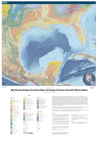
The formation of the Gulf of Mexico, an oceanic rift basin located between North America and the Yucatan Block, was preceded by the breakup of the Supercontinent Pangaea in the Late-Triassic, weakening the lithosphere. Rifting between the North and South American plates continued in the Early-Jurassic, approximately 160 million years ago, and formation of the Gulf of Mexico, including subsidence due to crustal thinning, was complete by 140 Ma. Stratigraphy of the basin, which can be split into several regions, includes sediments deposited from the Jurassic through the Holocene, currently totaling a thickness between 15 and 20 kilometers.

The geology of Germany is heavily influenced by several phases of orogeny in the Paleozoic and the Cenozoic, by sedimentation in shelf seas and epicontinental seas and on plains in the Permian and Mesozoic as well as by the Quaternary glaciations.

Patagonia comprises the southernmost region of South America, portions of which lie on either side of the Argentina-Chile border. It has traditionally been described as the region south of the Rio Colorado, although the physiographic border has more recently been moved southward to the Huincul fault. The region's geologic border to the north is composed of the Rio de la Plata craton and several accreted terranes comprising the La Pampa province. The underlying basement rocks of the Patagonian region can be subdivided into two large massifs: the North Patagonian Massif and the Deseado Massif. These massifs are surrounded by sedimentary basins formed in the Mesozoic that underwent subsequent deformation during the Andean orogeny. Patagonia is known for its vast earthquakes and the damage they cause.
The geology of Mauritania is built on more than two billion year old Archean crystalline basement rock in the Reguibat Shield of the West African Craton, a section of ancient and stable continental crust. Mobile belts and the large Taoudeni Basin formed and filled with sediments in the connection with the Pan-African orogeny mountain building event 600 million years ago and a subsequent orogeny created the Mauritanide Belt. In the last 251 million years, Mauritania has accumulated additional sedimentary rocks during periods of marine transgression and sea level retreat. The arid country is 50% covered in sand dunes and has extensive mineral resources, although iron plays the most important role in the economy.

The geology of Sierra Leone is primarily very ancient Precambrian Archean and Proterozoic crystalline igneous and metamorphic basement rock, in many cases more than 2.5 billion years old. Throughout Earth history, Sierra Leone was impacted by major tectonic and climatic events, such as the Leonean, Liberian and Pan-African orogeny mountain building events, the Neoproterozoic Snowball Earth and millions of years of weathering, which has produced thick layers of regolith across much of the country's surface.
This article describes the geology of Dartmoor National Park in Devon, in south-west England. Dartmoor gained national park status in 1951 but the designated area of 954 km2 (368 sq mi) extends beyond the upland of Dartmoor itself to include much of the surrounding land, particularly in the northeast. The geology of the national park consists of a 625 km2 (241 sq mi) core of granite intruded during the early Permian period into a sequence of sedimentary rocks originating in the Devonian and Carboniferous periods. These rocks were faulted and folded, sometimes, intensely, during the Variscan orogeny. Thermal metamorphism has also taken place around the margins of the granite pluton altering the character of the sedimentary rocks whilst mineral veins were emplaced within the granite. A small outlier of Palaeogene sediments occurs on the eastern boundary of the national park.
