The main chain of the Alps, also called the Alpine divide is the central line of mountains that forms the drainage divide of the range. Main chains of mountain ranges are traditionally designated in this way, and generally include the highest peaks of a range. The Alps are something of an unusual case in that several significant groups of mountains are separated from the main chain by sizable distances. Among these groups are the Dauphine Alps, the Eastern and Western Graians, the entire Bernese Alps, the Tödi, Albula and Silvretta groups, the Ortler and Adamello ranges, and the Dolomites of Veneto and South Tyrol, as well as the lower Alps of Vorarlberg, Bavaria, and Salzburg.

A mountain pass is a navigable route through a mountain range or over a ridge. Since mountain ranges can present formidable barriers to travel, passes have played a key role in trade, war, and both human and animal migration throughout history. At lower elevations it may be called a hill pass. A mountain pass is typically formed between two volcanic peaks or created by erosion from water or wind.

The Jungfraujoch is a saddle connecting two major 4000ers of the Bernese Alps: the Jungfrau and the Mönch. It lies at an elevation of 3,463 metres (11,362 ft) above sea level and is directly overlooked by the rocky prominence of the Sphinx. The Jungfraujoch is a glacier saddle, on the upper snows of the Aletsch Glacier, and part of the Jungfrau-Aletsch area, situated on the boundary between the cantons of Bern and Valais, halfway between Interlaken and Fiesch.

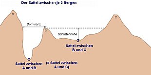
In topography, prominence or relative height measures the height of a mountain or hill's summit relative to the lowest contour line encircling it but containing no higher summit within it. It is a measure of the independence of a summit. The key col ("saddle") around the peak is a unique point on this contour line and the parent peak is some higher mountain, selected according to various criteria.

Rila is the highest mountain range of Bulgaria, the Balkan Peninsula, and Southeast Europe. It is situated in southwestern Bulgaria and forms part of the Rila–Rhodope Massif. The highest summit is Musala at an elevation of 2,925 m which makes Rila the sixth highest mountain range in Europe after the Caucasus, the Alps, Sierra Nevada, the Pyrenees and Mount Etna, and the highest one between the Alps and the Caucasus. It spans a territory of 2,629 km2 with an average elevation of 1487 m. The mountain is believed to have been named after the river of the same name, which comes from the Old Bulgarian verb "рыти" meaning "to grub".
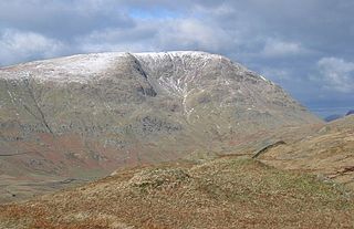
Red Screes is a fell in the English Lake District, situated between the villages of Patterdale and Ambleside. It may be considered an outlier of the Fairfield group in the Eastern Fells, but is separated from its neighbours by low cols. This gives Red Screes an independence which is reflected in its prominence.

The Barre des Écrins is a mountain in the French Alps with a peak elevation of 4,102 metres (13,458 ft). It is the highest peak of the Massif des Écrins and the Dauphiné Alps and the most southerly alpine peak in Europe that is higher than 4,000 metres. It is the only 4,000-metre mountain in France that lies outside the Mont Blanc Massif. Before the annexation of Savoy in 1860 it was the highest mountain in France.

A drainage divide, water divide, ridgeline, watershed, water parting or height of land is elevated terrain that separates neighboring drainage basins. On rugged land, the divide lies along topographical ridges, and may be in the form of a single range of hills or mountains, known as a dividing range. On flat terrain, especially where the ground is marshy, the divide may be difficult to discern.
A peak's line parent is the closest higher peak on the highest ridge leading away from the peak's "key col". A col is the lowest point on the ridge between two summits and is roughly synonymous with pass, gap, saddle and notch. The highest col of a peak is its key col. If there is more than one ridge which can be followed to a higher peak then the line parent is the peak closest to the key col. Usually, a line parent must meet some prominence criteria, which might vary depending on the author and the location of the peak.
A col in geomorphology is the lowest point on a mountain ridge between two peaks. It may also be called a gap or pass. Particularly rugged and forbidding cols in the terrain are usually referred to as notches. They are generally unsuitable as mountain passes, but are occasionally crossed by mule tracks or climbers' routes. Derived from the French col from Latin collum, "neck", the term tends to be associated more with mountain than hill ranges. The distinction with other names for breaks in mountain ridges such as saddle, wind gap or notch is not sharply defined and may vary from place to place. Many double summits are separated by prominent cols.

Ben Mor Coigach is the highest point along a ridge rising steeply from Loch Broom, in the far northwest of Scotland. It rises above the Coigach peninsula in the county of Ross and Cromarty, 10 kilometres northwest of Ullapool, reaching a height of 743 metres (2,438 ft). Its coastal position, combined with its high topographic prominence to height ratio, provides a spectacular panorama, sweeping from Ullapool across to the Summer Isles and north over the Coigach to the distinctive peaks of the Assynt, as well as more distant views to Skye and the Outer Hebrides, conditions permitting. The area is a Scottish Wildlife Trust nature reserve.

Mount Robie Reid 2,095 m (6,873 ft) is a mountain in the eastern part of Golden Ears Provincial Park in the southern end of the Garibaldi Ranges overlooking the Lower Mainland region of British Columbia, Canada. It lies to the north of Mission, British Columbia and on the west side of the upper end of Stave Lake, and to the northeast of the group of summits known as the Golden Ears. Mount Judge Howay is to the north. Robie Reid has a prominence of 1,245 m (4,085 ft) relative to the lowest col between the valleys of Tingle and Osprey Creeks.

The Weißenberg in the Palatine Forest is a hill in the municipality of Merzalben. Its height is variously give as 610 m above sea level (NHN) or 607 m above NHN. The higher value has been officially recommended since 2011. That makes the Weißenberg the highest point in the west of the mountain range, ahead of the Eschkopf and Mosisberg. As part of the Palatine Forest-North Vosges Biosphere Reserve it is protected by special conservation measures.

Mauch Chunk Ridge or Mauch Chunk Mountain is a historically important barrier ridgeline north of the Blue Mountain escarpment and 3rd parallel ridgeline south of the Nesquehoning Creek after Nesquehoning Mountain and Pisgah Ridge in the Ridge-and-Valley Appalachians of Northeastern Pennsylvania.

Haystack Mountain (Pennsylvania), is an otherwise non-descript 1871 ft peak forming the steep southwestern faces of the Solomon Gap mountain pass's saddle connecting and dividing the Wyoming Valley from the Lehigh Valley.