
Orogeny is a mountain building process that takes place at a convergent plate margin when plate motion compresses the margin. An orogenic belt or orogen develops as the compressed plate crumples and is uplifted to form one or more mountain ranges. This involves a series of geological processes collectively called orogenesis. These include both structural deformation of existing continental crust and the creation of new continental crust through volcanism. Magma rising in the orogen carries less dense material upwards while leaving more dense material behind, resulting in compositional differentiation of Earth's lithosphere. A synorogenic process or event is one that occurs during an orogeny.

Sedimentary basins are region-scale depressions of the Earth's crust where subsidence has occurred and a thick sequence of sediments have accumulated to form a large three-dimensional body of sedimentary rock. They form when long-term subsidence creates a regional depression that provides accommodation space for accumulation of sediments. Over millions or tens or hundreds of millions of years the deposition of sediment, primarily gravity-driven transportation of water-borne eroded material, acts to fill the depression. As the sediments are buried, they are subject to increasing pressure and begin the processes of compaction and lithification that transform them into sedimentary rock.

The Antler orogeny was a tectonic event that began in the early Late Devonian with widespread effects continuing into the Mississippian and early Pennsylvanian. Most of the evidence for this event is in Nevada but the limits of its reach are unknown. A great volume of conglomeratic deposits of mainly Mississippian age in Nevada and adjacent areas testifies to the existence of an important tectonic event, and implies nearby areas of uplift and erosion, but the nature and cause of that event are uncertain and in dispute. Although it is known as an orogeny, some of the classic features of orogeny as commonly defined such as metamorphism, and granitic intrusives have not been linked to it. In spite of this, the event is universally designated as an orogeny and that practice is continued here. This article outlines what is known and unknown about the Antler orogeny and describes three current theories regarding its nature and origin.
The geology of the Himalayas is a record of the most dramatic and visible creations of the immense mountain range formed by plate tectonic forces and sculpted by weathering and erosion. The Himalayas, which stretch over 2400 km between the Namcha Barwa syntaxis at the eastern end of the mountain range and the Nanga Parbat syntaxis at the western end, are the result of an ongoing orogeny — the collision of the continental crust of two tectonic plates, namely, the Indian Plate thrusting into the Eurasian Plate. The Himalaya-Tibet region supplies fresh water for more than one-fifth of the world population, and accounts for a quarter of the global sedimentary budget. Topographically, the belt has many superlatives: the highest rate of uplift, the highest relief, among the highest erosion rates at 2–12 mm/yr, the source of some of the greatest rivers and the highest concentration of glaciers outside of the polar regions. This last feature earned the Himalaya its name, originating from the Sanskrit for "the abode of the snow".

The Maracaibo Basin, also known as Lake Maracaibo natural region, Lake Maracaibo depression or Lake Maracaibo Lowlands, is a foreland basin and one of the eight natural regions of Venezuela, found in the northwestern corner of Venezuela in South America. Covering over 36,657 square km, it is a hydrocarbon-rich region that has produced over 30 billion bbl of oil with an estimated 44 billion bbl yet to be recovered. The basin is characterized by a large shallow tidal estuary, Lake Maracaibo, located near its center. The Maracaibo basin has a complex tectonic history that dates back to the Jurassic period with multiple evolution stages. Despite its complexity, these major tectonic stages are well preserved within its stratigraphy. This makes The Maracaibo basin one of the most valuable basins for reconstructing South America's early tectonic history.
Extensional tectonics is concerned with the structures formed by, and the tectonic processes associated with, the stretching of a planetary body's crust or lithosphere.

The geology of Norway encompasses the history of Earth that can be interpreted by rock types found in Norway, and the associated sedimentological history of soils and rock types.
The Sonoma orogeny was a period of mountain building in western North America. The exact age and structure of the Sonoma orogeny is controversial. The orogeny is generally thought to have occurred during the Permian / Triassic transition, around 250 million years ago, following the Late Devonian Antler orogeny. The Sonoma orogeny was one of a sequence of accretionary events along the Cordilleran margin, possibly caused by the closure of the basin between the island arc of Sonomia and the North American continent. Evidence of this event has been reported throughout western North America, but most distinctly in northwest Nevada.

The Pyrenees are a 430-kilometre-long, roughly east–west striking, intracontinental mountain chain that divide France, Spain, and Andorra. The belt has an extended, polycyclic geological evolution dating back to the Precambrian. The chain's present configuration is due to the collision between the microcontinent Iberia and the southwestern promontory of the European Plate. The two continents were approaching each other since the onset of the Upper Cretaceous (Albian/Cenomanian) about 100 million years ago and were consequently colliding during the Paleogene (Eocene/Oligocene) 55 to 25 million years ago. After its uplift, the chain experienced intense erosion and isostatic readjustments. A cross-section through the chain shows an asymmetric flower-like structure with steeper dips on the French side. The Pyrenees are not solely the result of compressional forces, but also show an important sinistral shearing.
Tectonic subsidence is the sinking of the Earth's crust on a large scale, relative to crustal-scale features or the geoid. The movement of crustal plates and accommodation spaces produced by faulting brought about subsidence on a large scale in a variety of environments, including passive margins, aulacogens, fore-arc basins, foreland basins, intercontinental basins and pull-apart basins. Three mechanisms are common in the tectonic environments in which subsidence occurs: extension, cooling and loading.

Growth faults are syndepositional or syn-sedimentary extensional faults that initiate and evolve at the margins of continental plates. They extend parallel to passive margins that have high sediment supply. Their fault plane dips mostly toward the basin and has long-term continuous displacement. Figure one shows a growth fault with a concave upward fault plane that has high updip angle and flattened at its base into zone of detachment or décollement. This angle is continuously changing from nearly vertical in the updip area to nearly horizontal in the downdip area.

Salt surface structures are extensions of salt tectonics that form at the Earth's surface when either diapirs or salt sheets pierce through the overlying strata. They can occur in any location where there are salt deposits, namely in cratonic basins, synrift basins, passive margins and collisional margins. These are environments where mass quantities of water collect and then evaporate; leaving behind salt and other evaporites to form sedimentary beds. When there is a difference in pressure, such as additional sediment in a particular area, the salt beds – due to the unique ability of salt to behave as a fluid under pressure – form into new structures. Sometimes, these new bodies form subhorizontal or moderately dipping structures over a younger stratigraphic unit, which are called allochthonous salt bodies or salt surface structures.

The Himalayan foreland basin is an active collisional foreland basin system in South Asia. Uplift and loading of the Eurasian Plate on to the Indian Plate resulted in the flexure (bending) of the Indian Plate, and the creation of a depression adjacent to the Himalayan mountain belt. This depression was filled with sediment eroded from the Himalaya, that lithified and produced a sedimentary basin ~3 to >7 km deep. The foreland basin spans approximately 2,000 kilometres (1,200 mi) in length and 450 kilometres (280 mi) in width. From west to east the foreland basin stretches across five countries: Pakistan, India, Nepal, Bangladesh, and Bhutan.
The Tyrrhenian Basin is a sedimentary basin located in the western Mediterranean Sea under the Tyrrhenian Sea. It covers a 231,000 km2 area that is bounded by Sardinia to the west, Corsica to the northwest, Sicily to the southeast, and peninsular Italy to the northeast. The Tyrrhenian basin displays an irregular seafloor marked by several seamounts and two distinct sub-basins - the Vavilov and Marsili basins. The Vavilov deep plain contains the deepest point of the Tyrrhenian basin at approximately 3785 meters. The basin trends roughly northwest–southeast with the spreading axis trending northeast–southwest.

The Kutai sedimentary basin extends from the central highlands of Borneo, across the eastern coast of the island and into the Makassar Strait. With an area of 60,000 km2, and depths up to 15 km, the Kutai is the largest and deepest Tertiary age basin in Indonesia. Plate tectonic evolution in the Indonesian region of SE Asia has produced a diverse array of basins in the Cenozoic. The Kutai is an extensional basin in a general foreland setting. Its geologic evolution begins in the mid Eocene and involves phases of extension and rifting, thermal sag, and isostatic subsidence. Rapid, high volume, sedimentation related to uplift and inversion began in the Early Miocene. The different stages of Kutai basin evolution can be roughly correlated to regional and local tectonic events. It is also likely that regional climate, namely the onset of the equatorial ever wet monsoon in early Miocene, has affected the geologic evolution of Borneo and the Kutai basin through the present day. Basin fill is ongoing in the lower Kutai basin, as the modern Mahakam River delta progrades east across the continental shelf of Borneo.

The Nordfjord—Sogn Detachment (NSD) is a major extensional shear zone up to 6 km in thickness, which extends about 120 km along strike from Nordfjord to Sognefjord, bringing Devonian continental coarse clastic sedimentary rocks into close contact with eclogite facies metamorphic rocks of the Western Gneiss Region. It formed towards the end of the Caledonian Orogeny and was mainly active during the Devonian. It has an estimated displacement of at least 70 km and possibly as much as 110 km. It was reactivated during the Mesozoic and may have influenced the development of fault structures in the North Sea rift basin.
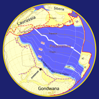
One of the major depositional strata in the Himalaya is the Lesser Himalayan Strata from the Paleozoic to Mesozoic eras. It had a quite different marine succession during the Paleozoic, as most parts of it are sparsely fossiliferous or even devoid of any well-defined fossils. Moreover, it consists of many varied lithofacies, making correlation work more difficult. This article describes the major formations of the Paleozoic – Mesozoic Lesser Himalayan Strata, including the Tal Formation, Gondwana Strata, Singtali Formation and Subathu Formation.
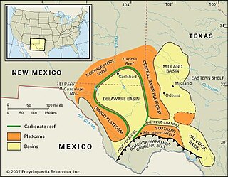
The Val Verde Basin is a marginal foreland basin located in West Texas, just southeast of the Midland Basin. The Val Verde is a sub-basin of the larger Permian Basin and is roughly 24–40 km wide by 240 km long. It is an unconventional system and its sediments were deposited during a long period of flooding during the Middle to Late Cretaceous. This flooding event is referred to as the Western Interior Seaway, and many basins in the Western United States can attribute their oil and gas producing basins to carbonate deposition during this time period.

The Cook Inlet Basin is a northeast-trending collisional forearc basin that stretches from the Gulf of Alaska into South central Alaska, just east of the Matanuska Valley. It is located in the arc-trench gap between the Alaska-Aleutian Range batholith and contains roughly 80,000 cubic miles of sedimentary rocks. These sediments are mainly derived from Triassic, Jurassic and Cretaceous sediments.

The Hornelen Basin is a sedimentary basin in Vestland, Norway, containing an estimated 25 km stratigraphic thickness of coarse clastic sedimentary rocks of Devonian age. It forms part of a group of basins of similar age along the west coast of Norway between Sognefjord and Nordfjord, related to movement on the Nordfjord-Sogn Detachment. It formed as a result of extensional tectonics as part of the post-orogenic collapse of crust that was thickened during the Caledonian Orogeny towards the end of the Silurian period. It is named for the mountain Hornelen on the northern margin of the basin.

