
Mauna Loa is one of five volcanoes that form the Island of Hawaii in the U.S. state of Hawaii in the Pacific Ocean. Mauna Loa is Earth's largest active volcano by both mass and volume. It was historically considered to be the largest volcano on Earth until Tamu Massif was discovered to be larger. Mauna Loa is a shield volcano with relatively gentle slopes, and a volume estimated at 18,000 cubic miles (75,000 km3), although its peak is about 125 feet (38 m) lower than that of its neighbor, Mauna Kea. Lava eruptions from Mauna Loa are silica-poor and very fluid, and tend to be non-explosive.

A shield volcano is a type of volcano named for its low profile, resembling a shield lying on the ground. It is formed by the eruption of highly fluid lava, which travels farther and forms thinner flows than the more viscous lava erupted from a stratovolcano. Repeated eruptions result in the steady accumulation of broad sheets of lava, building up the shield volcano's distinctive form.

Kīlauea is an active shield volcano in the Hawaiian Islands. Located along the southeastern shore of Hawai'i Island, the volcano is between 210,000 and 280,000 years old and emerged above sea level about 100,000 years ago. Historically, it is the most active of the five volcanoes that together form the island of Hawaii. Kīlauea is also one of the most active volcanoes on Earth, with the most recent eruption occurring for a week in September 2023 when multiple vents erupted lava within the volcano's summit caldera inside Halemaʻumaʻu crater.

Hualālai is an active volcano on the island of Hawaiʻi in the Hawaiian Islands. It is the westernmost, third-youngest and the third-most active of the five volcanoes that form the island of Hawaiʻi, following Kīlauea and the much larger Mauna Loa. Its peak stands 8,271 feet (2,521 m) above sea level. Hualālai is estimated to have risen above sea level about 300,000 years ago. Despite maintaining a very low level of activity since its last eruption in 1801, and being unusually inactive for the last 2,000 years, Hualālai is still considered active, and is expected to erupt again sometime in the next 100 years. The relative unpreparedness of the residents in the area caused by the lull in activity would worsen an eruption's consequences.
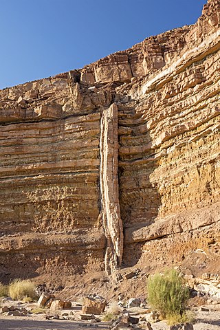
In geology, a dike or dyke is a sheet of rock that is formed in a fracture of a pre-existing rock body. Dikes can be either magmatic or sedimentary in origin. Magmatic dikes form when magma flows into a crack then solidifies as a sheet intrusion, either cutting across layers of rock or through a contiguous mass of rock. Clastic dikes are formed when sediment fills a pre-existing crack.

Porak or Akharbakhar is a stratovolcano located in the Vardenis volcanic ridge. It lies about 20 km (12 mi) southeast of Lake Sevan and the volcanic field spans the border between Armenia and Azerbaijan with lava flows running into both countries. Ten satellite cones and fissure vents lie on the flanks of the volcano.
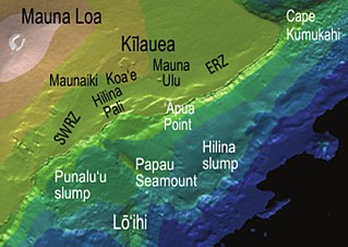
The Hilina Slump, on the south flank of the Kīlauea Volcano on the southeast coast of the Big Island of Hawaiʻi, is the most notable of several landslides that ring each of the Hawaiian Islands. These landslides are the means by which material deposited at a volcano's vents are transferred downward and seaward, eventually spilling onto the seabed to broaden the island.

A Hawaiian eruption is a type of volcanic eruption where lava flows from the vent in a relatively gentle, low level eruption; it is so named because it is characteristic of Hawaiian volcanoes. Typically they are effusive eruptions, with basaltic magmas of low viscosity, low content of gases, and high temperature at the vent. Very small amounts of volcanic ash are produced. This type of eruption occurs most often at hotspot volcanoes such as Kīlauea on Hawaii's big island and in Iceland, though it can occur near subduction zones and rift zones. Hawaiian eruptions may occur along fissure vents, such as during the eruption of Mauna Loa in 1950, or at a central vent, such as during the 1959 eruption in Kīlauea Iki Crater, which created a lava fountain 580 meters (1,900 ft) high and formed a 38-meter cone named Puʻu Puaʻi. In fissure-type eruptions, lava spurts from a fissure on the volcano's rift zone and feeds lava streams that flow downslope. In central-vent eruptions, a fountain of lava can spurt to a height of 300 meters or more.

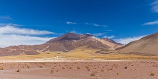
Quetrupillán is a stratovolcano located in Los Ríos Region of Chile. It is situated between Villarrica and Lanín volcanoes, within Villarrica National Park. Geologically, Quetrupillán is located in a tectonic basement block between the main traces of Liquiñe-Ofqui Fault and Reigolil-Pirihueico Fault.

Several types of volcanic eruptions—during which lava, tephra, and assorted gases are expelled from a volcanic vent or fissure—have been distinguished by volcanologists. These are often named after famous volcanoes where that type of behavior has been observed. Some volcanoes may exhibit only one characteristic type of eruption during a period of activity, while others may display an entire sequence of types all in one eruptive series.

Ollagüe or Ullawi is a massive andesite stratovolcano in the Andes on the border between Bolivia and Chile, within the Antofagasta Region of Chile and the Potosi Department of Bolivia. Part of the Central Volcanic Zone of the Andes, its highest summit is 5,868 metres (19,252 ft) above sea level and features a summit crater that opens to the south. The western rim of the summit crater is formed by a compound of lava domes, the youngest of which features a vigorous fumarole that is visible from afar.
Cerro del Azufre is a stratovolcano located in El Loa Province, Antofagasta Region, Chile. It is part of a chain of volcanoes that separate Upper Loa River basin from Salar de Ascotán basin and is flanked to the west by a dacitic lava dome called Chanka or Pabellón. The 6000 metre volcanoes San Pedro and San Pablo are located to the southwest of Cerro del Azufre.

A flank eruption is a volcanic eruption which occurs on the flanks of a volcano, instead of at its summit. Such eruptions occur when the conduit connecting the summit to the magma chamber below is blocked, forcing the magma to move laterally.

Littoral cones are a form of volcanic cone. They form from the interaction between lava flows and water. Steam explosions fragment the lava and the fragments can pile up and form a cone. Such cones usually form on ʻaʻā lava flows, and typically are formed only by large lava flows. They have been found on Hawaii and elsewhere.

Lastarria is a 5,697 metres (18,691 ft) high stratovolcano that lies on the border between Chile and Argentina. It is remote, and the surroundings are uninhabited but can be reached through an unpaved road. The volcano is part of the Central Volcanic Zone, one of the four segments of the volcanic arc of the Andes. Over a thousand volcanoes—of which about 50 are active—lie in this over 1,500 kilometres (930 mi) long chain of volcanoes, which is generated by subduction of the Nazca Plate beneath the South American Plate.

The 1984 eruption of Mauna Loa was a Hawaiian eruption in the U.S. state of Hawaii that lasted from March 25 to April 15, 1984. It ended a 9-year period of quiescence at the volcano and continued for 22 days, during which time lava flows and lava fountains issued from the summit caldera and fissures along the northeast and southwest rift zones. Although the lava threatened Hilo, the flow stopped before reaching the outskirts of town.

The 1975 eruption of Mauna Loa was a short-lived Hawaiian eruption that followed 25 years of quiescence at the Hawaiian volcano Mauna Loa. The eruption began just before midnight on July 5 and involved fissures extending across the length of Moku‘āweoweo, Mauna Loa's summit caldera, and into the upper ends of the volcano's northeast and southwest rift zones. After only 6 hours, activity in Moku‘āweoweo and on the southwest rift zone ended, but lava fountaining continued along the northeast rift zone until 7:30 p.m. on July 6, when all activity ceased.

Rauðhólar (Vesturdalur) is a small chain of volcanoes within the Askja or the Fremrinámur volcanic systems in the north of Iceland.

The Reykjanes Peninsula in southwest Iceland is the continuation of the mostly submarine Reykjanes Ridge, a part of the Mid-Atlantic Ridge, on land and reaching from Esja in the north and Hengill in the east to Reykjanestá in the west. Suðurnes is an administrative unit covering part of Reykjanes Peninsula.
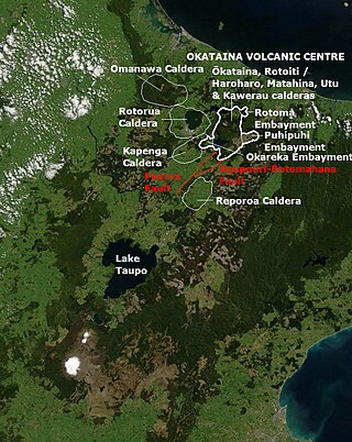
Ōkataina Caldera is a volcanic caldera and its associated volcanoes located in Taupō Volcanic Zone of New Zealand's North Island. It has several actual or postulated sub calderas. The Ōkataina Caldera is just east of the smaller Rotorua Caldera and southwest of the much smaller Rotomā Embayment which is usually regarded as an associated volcano. It shows high rates of explosive rhyolitic volcanism although its last eruption was basaltic. The postulated Haroharo Caldera contained within it has sometimes been described in almost interchangeable terms with the Ōkataina Caldera or volcanic complex or centre and by other authors as a separate complex defined by gravitational and magnetic features.. Since 2010 other terms such as the Haroharo vent alignment, Utu Caldera, Matahina Caldera, Rotoiti Caldera and a postulated Kawerau Caldera are often used, rather than a Haroharo Caldera classification.
