Epicentral distance

Last updated
Diagram of the epicenter Epicenter Diagram.svg
Diagram of the epicenter

Epicentral distance refers to the ground distance from the epicenter to a specified point. [1] Generally, the smaller the epicentral distance of an earthquake of the same scale, the heavier the damage caused by the earthquake. On the contrary, with the increase of epicentral distance, the damage caused by the earthquake is gradually reduced. [2] Due to the limitation of seismometers designed in the early years, some seismic magnitude scales began to show errors when the epicentral distance exceeded a certain range from the observation points. [Notes 1] In seismology, the unit of far earthquakes is usually ° (degree), while the unit of near earthquakes is km. [Notes 2] But regardless of distance, Δ is used as a symbol for the epicentral distance.

Contents

Measuring method

S-P time difference method

Even if the depth of focus of an earthquake is very deep, it can still have a very short epicentral distance. [3] When measuring the epicentral distance of an earthquake with a small epicentral distance, first measure the reading of the initial motion of P wave, and then confirm the arrival of S wave. [Notes 3] The value of the epicenter distance Δ is found on the travel timetable according to the arrival time difference between the P wave and S wave. [4]

Other Methods

If the source is very far away, that is, when the epicenter distance is greater than 105 °, [Notes 4] the epicenter distance cannot be determined according to the S-P move out method so it must be determined by P, PKP, PP, SKS, PS, and other waves. [4]

Correlation with seismic measurement

Definition of near earthquake magnitude

In 1935, in the absence of a mature seismic magnitude scales, two seismologists from the California Institute of Technology, Charles Francis Richter and Bino Gutenberg, designed the Richter magnitude scale to study the earthquakes that occurred in California, USA. [Notes 5] In order to keep the result from being negative, Richter defined an earthquake with a maximum horizontal displacement of 1 μ m (which is also the highest accuracy and precision of the Wood Anderson torsion seismometer) recorded by the seismometer at the observation point at the epicentral distance of 100 km as a magnitude 0 earthquake. According to this definition, if the amplitude of the seismic wave measured by the Wood Anderson torsion seismometer at the epicentral distance of 100 km is 1 mm, then the magnitude is 3. [Notes 6] Although Richter et al. attempted to make the results non-negative, modern precision seismographs often record earthquakes with negative scales due to the lack of clear upper or lower limits on the magnitude of nearby earthquakes. [5] Moreover, due to the limitation of the Wood Anderson torsion seismometer used in the original design of the Richter scale, if the local earthquake scale ML is greater than 6.8 or the epicentral distance exceeds about 600 km the observation point, it is not applicable. [6]

Calculation of surface wave magnitude

The epicentral distance is one of the important parameters for calculating surface-wave magnitude. The equation for calculating surface wave magnitude is

In this equation, represents the maximum particle displacement in the surface wave (sum of two horizontal Euclidean vectors), in micrometers; T represents the corresponding period, in seconds; Δ Is the epicentral distance, in degrees; and is a gauge function. Generally, the expression for the gauge function is

According to GB 17740-1999, two horizontal displacements must be measured at the same time or one-eighth of a period. If two displacements have different cycles, weighted summation must be used. [7]

Among them, AN represents the displacement in the north-south direction, in micrometers; AE represents the displacement in the east-west direction, in micrometers; TN represents the period of the corresponding AN, in seconds; TE represents the period corresponding to AE, in seconds. [8] [9]

It can be seen that the seismic surface wave period value selected for different epicentral distances is different. Generally, the cycle values can be selected by referring to the table below. [7]

Different epicentral distance( Δ) Selected seismic surface wave period (T) value
Δ/°T/sΔ/°T/sΔ/°T/s
23~6209~147014~22
44~7259~168016~22
65~83010~169016~22
86~94012~1810016~25
107~105012~2011017~25
158~126014~2013018~25

Rapid report of large earthquakes with surface wave magnitude

In addition to the calculation of surface wave magnitude (Δ≤15°) body wave attenuation characteristics and better conversion relationship between MB and MS are effective ways to improve the longitude of Body wave magnitude MB rapid report of large earthquakes. This is also a meaningful quantitative work for carrying out research on the measurement of Body wave magnitude MB recorded by short period instrument DD-1 and VGK. [10]

Correlation with epicenter

Schematic diagram of the trilateral measurement method. The specific method for calculating the epicenter is to take three stations as the center of the circle, and draw a circle on the map with the radius of the epicentral distance calculated by each station according to the corresponding proportion. Then, connect the intersection points of each two circles, and the intersection points of the three chords are the obtained epicenters. Then, calculate the longitude and latitude. 3spheres.svg
Schematic diagram of the trilateral measurement method. The specific method for calculating the epicenter is to take three stations as the center of the circle, and draw a circle on the map with the radius of the epicentral distance calculated by each station according to the corresponding proportion. Then, connect the intersection points of each two circles, and the intersection points of the three chords are the obtained epicenters. Then, calculate the longitude and latitude.

Before the 20th century, the method of determining the epicenter was generally the geometric center method. Since the beginning of the 20th century, as the technology of seismometers and other instruments gradually matured, the single station measurement method and network measurement method were born. Compared to the three methods, due to the influence of uneven crustal structure on the propagation of seismic rays, [Notes 7] the network measurement method has the highest accuracy, while the geometric center method has the lowest accuracy. [1] [11]

Geometric center method

Before the 20th century, in the absence of instrument records, the epicenter position of earthquakes was determined by the macroscopic epicenter based on the extent of damage, which was the geometric center of the epicenter area (the area near the epicenter where the damage was most severe). Due to the inability to determine the precise range of the polar region, errors were often caused. [12]

Single station measurement method

Due to the varying propagation speeds of various seismic waves in different regions and depths, those with fast wave speeds or diameters first arrive at the station, followed by other waves, resulting in a time difference. [Notes 8] The epicentral distance, source depth, and time difference of various recorded waves can be compiled into time distance curves and travel timetables suitable for local use. When an earthquake occurs in a certain place, the analyst can measure the time difference of various waves of the earthquake from the seismogram and calculate the epicentral distance by comparing it with the prepared travel timetable or applying the formula. Subsequently, it is necessary to determine the azimuth angle. [Notes 9] Transforming the initial motion amplitudes in two horizontal directions into ground motion displacements, the azimuth angle can be determined using a trigonometric function. After the azimuth and epicentral distance are calculated, the epicenter position can be easily found. [11] This method is called the single station measurement method. [Notes 10]

Network measurement method

When the epicentral distance is calculated by at least three seismic stations, the location of the epicenter can be determined by trilateral measurement. [13] This method of measuring epicenters through instruments, commonly known as microscopic epicenters, is called network measurement method. [1] [Notes 11] The specific method is done by drawing a circle on the map with the three stations as the center of the circle and the epicentral distance is calculated with the radius according to the corresponding proportion. Then, the intersection of each two circles is connected, and the intersection points of the three strings are the obtained epicenter. Then, the latitude and longitude are calculated (Geographic coordinate system). [11]

Others

Seismic classification

Epicentral distance also plays a unique role in earthquake classification. The same earthquake is called differently when observed at different distances, near and far. According to epicentral distance, earthquakes can be divided into three categories: [4]

Seismic phase study

The epicentral distance is different, and the seismic phases are reflected in different patterns on the seismic record map due to the combined effects of the source, the source depth, and the propagation of seismic rays. Therefore, with the different epicentral distances, the determination of seismic parameters will be different. Given the epicentral distance from the observation points, it is easier to distinguish complex and different seismic phases, which are generally judged according to the overall situation of seismic records on the record map. The size, distance, and depth of earthquakes have distinct characteristics. The closer the source is, the shorter the duration of the vibration; the farther the source, the longer the duration. [4]

Notes

  1. It is not applicable if the epicentral distance of the near earthquake magnitude at the observation point exceeds about 600 km.
  2. Generally, 1 °=111.1 kilometers.
  3. The S-wave is the second clear seismic phase on long period horizontal instruments, while it is less obvious on short period vertical instruments.
  4. Or approximately 11666.7 kilometers.
  5. This earthquake measure is also known as the "Richter scale earthquake".
  6. 103 microns.
  7. Especially events that occur within the scope of the seismic network.
  8. Direct wave.
  9. Commonly used P-wave and S-wave.
  10. Some scholars also refer to it as the "azimuth method"
  11. Some scholars also refer to it as the "intersection method" or "geometric method" after further conversion

Related Research Articles

The Modified Mercalli intensity scale measures the effects of an earthquake at a given location. This is in contrast with the seismic magnitude usually reported for an earthquake.

<span class="mw-page-title-main">Epicenter</span> Point on the Earths surface that is directly above the hypocentre or focus in an earthquake

The epicenter, epicentre, or epicentrum in seismology is the point on the Earth's surface directly above a hypocenter or focus, the point where an earthquake or an underground explosion originates.

<span class="mw-page-title-main">Seismometer</span> Instrument that records seismic waves by measuring ground motions

A seismometer is an instrument that responds to ground noises and shaking such as caused by quakes, volcanic eruptions, and explosions. They are usually combined with a timing device and a recording device to form a seismograph. The output of such a device—formerly recorded on paper or film, now recorded and processed digitally—is a seismogram. Such data is used to locate and characterize earthquakes, and to study the internal structure of Earth.

<span class="mw-page-title-main">Japan Meteorological Agency seismic intensity scale</span> Japanese earthquake measurements

The Japan Meteorological Agency (JMA) Seismic Intensity Scale is a seismic intensity scale used in Japan to categorize the intensity of local ground shaking caused by earthquakes.

The moment magnitude scale is a measure of an earthquake's magnitude based on its seismic moment. Mw was defined in a 1979 paper by Thomas C. Hanks and Hiroo Kanamori. Similar to the local magnitude/Richter scale (ML ) defined by Charles Francis Richter in 1935, it uses a logarithmic scale; small earthquakes have approximately the same magnitudes on both scales. Despite the difference, news media often says "Richter scale" when referring to the moment magnitude scale.

Peak ground acceleration (PGA) is equal to the maximum ground acceleration that occurred during earthquake shaking at a location. PGA is equal to the amplitude of the largest absolute acceleration recorded on an accelerogram at a site during a particular earthquake. Earthquake shaking generally occurs in all three directions. Therefore, PGA is often split into the horizontal and vertical components. Horizontal PGAs are generally larger than those in the vertical direction but this is not always true, especially close to large earthquakes. PGA is an important parameter for earthquake engineering, The design basis earthquake ground motion (DBEGM) is often defined in terms of PGA.

Seismic magnitude scales are used to describe the overall strength or "size" of an earthquake. These are distinguished from seismic intensity scales that categorize the intensity or severity of ground shaking (quaking) caused by an earthquake at a given location. Magnitudes are usually determined from measurements of an earthquake's seismic waves as recorded on a seismogram. Magnitude scales vary based on what aspect of the seismic waves are measured and how they are measured. Different magnitude scales are necessary because of differences in earthquakes, the information available, and the purposes for which the magnitudes are used.

<span class="mw-page-title-main">1920 Haiyuan earthquake</span> 1920 earthquake in central China

The 1920 Haiyuan earthquake occurred on December 16 in Haiyuan County, Ningxia Province, Republic of China at 19:05:53. It was also called the 1920 Gansu earthquake because Ningxia was a part of Gansu Province when the earthquake occurred. It caused destruction in the Lijunbu-Haiyuan-Ganyanchi area and was assigned the maximum intensity on the Mercalli intensity scale. About 258,707~273,407 died, making it one of the most fatal earthquakes in China, in turn making it one of the worst disasters in China by death toll.

The surface wave magnitude scale is one of the magnitude scales used in seismology to describe the size of an earthquake. It is based on measurements of Rayleigh surface waves that travel along the uppermost layers of the Earth. This magnitude scale is related to the local magnitude scale proposed by Charles Francis Richter in 1935, with modifications from both Richter and Beno Gutenberg throughout the 1940s and 1950s. It is currently used in People's Republic of China as a national standard for categorising earthquakes.

The successful development of the local-magnitude scale encouraged Gutenberg and Richter to develop magnitude scales based on teleseismic observations of earthquakes. Two scales were developed, one based on surface waves, , and one on body waves, . Surface waves with a period near 20 s generally produce the largest amplitudes on a standard long-period seismograph, and so the amplitude of these waves is used to determine , using an equation similar to that used for .

<span class="mw-page-title-main">Earthquake Early Warning (Japan)</span> Japanese system to alert of impending earthquakes

In Japan, the Earthquake Early Warning (EEW) is a warning issued when an earthquake is detected by multiple seismometers. These warnings are primarily issued by the Japan Meteorological Agency (JMA), with guidance on how to react to them.

<span class="mw-page-title-main">2008 Panzhihua earthquake</span>

The 2008 Panzhihua earthquake struck southern Sichuan province, China on August 30 at 16:30:50.5 China Standard Time with a surface wave magnitude of 6.1, or 6.0 Mw. It is also cited as the Renhe-Huili earthquake, especially in SCEA reports and early CEA reports. It was not an aftershock of the Sichuan earthquake that occurred several months prior. With more than 400 aftershocks, it caused over 40 deaths, the collapse of 10,000 homes and damage to other infrastructure in the provinces of Sichuan and Yunnan. The maximum liedu was VIII.

The Richter scale, also called the Richter magnitude scale, Richter's magnitude scale, and the Gutenberg–Richter scale, is a measure of the strength of earthquakes, developed by Charles Francis Richter in collaboration with Beno Gutenberg, and presented in Richter's landmark 1935 paper, where he called it the "magnitude scale". This was later revised and renamed the local magnitude scale, denoted as ML or ML .

A potent magnitude 6.6 Mw intraplate aftershock occurred at 17:16 JST (08:16 UTC) on 11 April, in the Hamadōri region of Fukushima, Japan. With a shallow focus of 13 km (8.1 mi), the earthquake was centred inland about 36 km (22 mi) west of Iwaki, causing widespread strong to locally severe shaking. It was one of many aftershocks to follow the 11 March Tōhoku earthquake, and the strongest to have its epicentre located inland.

<span class="mw-page-title-main">2014 Ludian earthquake</span> 6.1 magnitude earthquake in Yunnan, China

The 2014 Ludian earthquake struck Ludian County, Yunnan, China, with a moment magnitude of 6.1 on 3 August. The earthquake killed at least 617 people, injuring at least 2,400 others. As of 5 August 2014, 112 people remain missing. Over 12,000 houses collapsed and 30,000 were damaged. According to the United States Geological Survey, the earthquake occurred 29 km (18 mi) WSW of Zhaotong city at 16:30 local time (08:30 UTC).

The 1902 Turkestan earthquake devastated Xinjiang, China, near the Kyrgyzstan border. It occurred on August 22, 1902, at 03:00:22 with an epicenter in the Tien Shan mountains. The thrust earthquake measured 7.7 on the moment magnitude scale (Mw ) and had a depth of 18 km (11 mi).

The 2021 Luxian earthquake was a damaging seismic event occurring in the early hours of September 16 at 04:33 China Standard Time. The surface wave magnitude (Ms ) 6.0 or moment magnitude (Mw ) 5.4 earthquake struck at a shallow depth of 7.5 km and severe shaking in an area of 4,000 square kilometers was assigned a maximum intensity of VIII on the China seismic intensity scale. Three people were killed and 146 injured when the earthquake struck Lu County, Luzhou, Sichuan Province. At least 36,800 buildings were affected, 7,800 of them seriously damaged or completely destroyed, causing about a quarter of a billion dollars worth of damage.

<span class="mw-page-title-main">2022 Ya'an earthquake</span> Earthquake in Sichuan Province, China

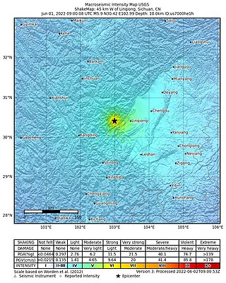
On June 1, 2022, a moment magnitude (Mw ) 5.8 or surface-wave magnitude (Ms ) 6.1 earthquake struck Lushan County in Ya'an, Sichuan Province, China. At least four people were killed and 42 were injured. The earthquake had a maximum intensity of VIII on the China seismic intensity scale, causing damage to many homes and triggering rockslides.

<span class="mw-page-title-main">2022 Luding earthquake</span> Earthquake in China

A Mw 6.7 earthquake struck Luding County in Sichuan province, China on 5 September 2022 at 12:52:19 local time. The epicenter was located 226 km (140 mi) from Chengdu, or 43 km (27 mi) southeast of Kangding. Ninety-three people died, 424 were injured and 24 remained missing. More than 13,000 homes and other infrastructure were damaged or destroyed. It was the largest earthquake to strike the province since 2017.

<span class="mw-page-title-main">Wood–Anderson seismometer</span> Instrument fo measuring strength of earthquakes

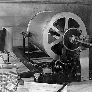
The Wood–Anderson seismometer is a torsion seismometer developed in the United States by Harry O. Wood and John August Anderson in the 1920s to record local earthquakes in southern California. It photographically records the horizontal motion. The seismometer uses a pendulum of 0.8g, its period is 0.8 seconds, its magnification is 2,800 times, and its damping constant is 0.8. Charles Francis Richter developed the Richter magnitude scale using the Wood–Anderson seismometer.

References

  1. 1 2 3 "地震参数的测定". 山西地震 (4): 3–4. 1981.
  2. "烈度一震中距一震级之间的关系". 地震学会讲演予稿集 (2): 206. 1983.
  3. "Earthquake Hazards 201 - Technical Q&A". United States Geological Survey. Archived from the original on 2017-07-09. Retrieved 2017-10-18.
  4. 1 2 3 4 "地震参数的测定". 山西地震 (4): 19. 1981.
  5. "Measuring the Size of an Earthquake". USGS. Archived from the original on 2017-12-06. Retrieved 2017-12-02.
  6. "On Earthquake Magnitudes". 香港天文台. 2012. Archived from the original on 2017-05-24. Retrieved 2017-12-02.
  7. 1 2 "GB 17740-1999 地震震级的规定". 中华人民共和国国家质量监督检验检疫总局: 3. 1999-04-26.
  8. "地震参数的测定". 山西地震 (4): 26. 1981.
  9. "震中距△〈20°面波震级的测定". 地震地磁观测与研究 (1): 1–8. 1992.
  10. "大地震震级测定及速报". 地震地磁观测与研究 (1): 23. 1992.
  11. 1 2 3 "地震是这样测定的". 深圳特区科技 (4): 39. 1990.
  12. "如何提取更多的地震信息". 石油地球物理勘探. 1: 48–50. 1979.
  13. "Earthquake Size". Pennstate Earthquake Seismology. Archived from the original on 2017-06-11. Retrieved 2017-10-18.