
Bryce Canyon National Park is an American national park located in southwestern Utah. The major feature of the park is Bryce Canyon, which despite its name, is not a canyon, but a collection of giant natural amphitheaters along the eastern side of the Paunsaugunt Plateau. Bryce is distinctive due to geological structures called hoodoos, formed by frost weathering and stream erosion of the river and lake bed sedimentary rock. The red, orange, and white colors of the rocks provide spectacular views for park visitors. Bryce Canyon National Park is much smaller and sits at a much higher elevation than nearby Zion National Park. The rim at Bryce varies from 8,000 to 9,000 feet.

Washington County is a county in the southwestern corner of Utah, United States. As of the 2020 United States Census, the population was 180,279, making it the fifth-most populous county in Utah. Its county seat and largest city is St. George. The county was created in 1852 and organized in 1856. It was named after the first President of the United States, George Washington. A portion of the Paiute Indian Reservation is in western Washington County. Washington County comprises the St. George, UT Metropolitan Statistical Area.

Cedar Breaks National Monument is a U.S. National Monument located in the U.S. state of Utah near Cedar City. Cedar Breaks is a natural amphitheater, stretching across 3 miles (4.8 km), with a depth of over 2,000 feet (610 m). The elevation of the rim of the amphitheater is over 10,000 feet (3,000 m) above sea level. Rising above the rim is the prominent Brian Head, the peak of which lies a short distance outside of the National Monument boundary.

The Narrows is the narrowest section of Zion Canyon in Zion National Park, Utah, United States. Situated on the North Fork of the Virgin River and upstream of the main canyon, The Narrows is one of the premier hikes in the park and on the Colorado Plateau. The Narrows refers to both the 3.6-mile (5.8 km) bottom-up hike from the Temple of Sinawava to Big Springs, as well as the 16-mile (26 km) top-down hike from Chamberlain's Ranch back to the Temple of Sinawava.

The geology of the Zion and Kolob canyons area includes nine known exposed formations, all visible in Zion National Park in the U.S. state of Utah. Together, these formations represent about 150 million years of mostly Mesozoic-aged sedimentation in that part of North America. Part of a super-sequence of rock units called the Grand Staircase, the formations exposed in the Zion and Kolob area were deposited in several different environments that range from the warm shallow seas of the Kaibab and Moenkopi formations, streams and lakes of the Chinle, Moenave, and Kayenta formations to the large deserts of the Navajo and Temple Cap formations and dry near shore environments of the Carmel Formation.
The exposed geology of the Bryce Canyon area in Utah shows a record of deposition that covers the last part of the Cretaceous Period and the first half of the Cenozoic era in that part of North America. The ancient depositional environment of the region around what is now Bryce Canyon National Park varied from the warm shallow sea in which the Dakota Sandstone and the Tropic Shale were deposited to the cool streams and lakes that contributed sediment to the colorful Claron Formation that dominates the park's amphitheaters.

The Colorado Plateau, also known as the Colorado Plateau Province, is a physiographic and desert region of the Intermontane Plateaus, roughly centered on the Four Corners region of the southwestern United States. This province covers an area of 336,700 km2 (130,000 mi2) within western Colorado, northwestern New Mexico, southern and eastern Utah, northern Arizona, and a tiny fraction in the extreme southeast of Nevada. About 90% of the area is drained by the Colorado River and its main tributaries: the Green, San Juan, and Little Colorado. Most of the remainder of the plateau is drained by the Rio Grande and its tributaries.

The Grand Staircase is an immense sequence of sedimentary rock layers that stretch south from Bryce Canyon National Park and Grand Staircase–Escalante National Monument, through Zion National Park, and into Grand Canyon National Park.

The Paunsaugunt Plateau is a dissected plateau, rising to an elevation of 7,000–9,300 feet (2,100–2,800 m), in southwestern Utah in the United States. Located in northern Kane County and southwestern Garfield County, it is approximately 10 miles (16 km) wide, and extends southward from the Sevier Plateau approximately 25 miles (40 km), terminating in the Pink Cliffs at the southern end.
The Pink Cliffs are a series of highly dissected cliffs on the Colorado Plateau in Garfield, Iron, and Kane counties in southwestern Utah, United States. Contrary to the implication of the name, the cliffs are not a single set of rock formations, but actually a geological formation that manifests itself in multiple sets of rock formations.

Utah Tech University (UT), formerly Dixie State University (DSU), is a polytechnic 4-year public university in St. George, Utah. The university offers doctoral degrees, master's degrees, bachelor's degrees, associate degrees, and certifications. As of fall 2022, there are 12,556 students enrolled at UT.
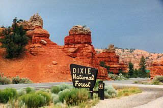
Dixie National Forest is a United States National Forest in Utah with headquarters in Cedar City. It occupies almost two million acres (8,000 km2) and stretches for about 170 miles (270 km) across southern Utah. The largest national forest in Utah, it straddles the divide between the Great Basin and the Colorado River. In descending order of forestland area it is located in parts of Garfield, Washington, Iron, Kane, Wayne, and Piute counties. The majority of forest acreage lies in Garfield County.
The Utah Parks Company, a subsidiary of Union Pacific Railroad, owned and operated restaurants, lodging, and bus tours in Bryce Canyon and Zion National Parks, the north rim of Grand Canyon National Park, and Cedar Breaks National Monument from the 1920s until 1972. Operating as a concessionaire of the National Park Service, the company operated from a base in Cedar City, Utah. The company's bus tours connected there with Union Pacific trains as well as tour buses from Los Angeles, San Francisco and other west coast cities, and offered a loop tour of the region's parks and monuments, escorted by a Utah Parks Company driver/guide.

The following is an alphabetical list of articles related to the U.S. state of Utah.

Zion National Park is an American national park located in southwestern Utah near the town of Springdale. Located at the junction of the Colorado Plateau, Great Basin, and Mojave Desert regions, the park has a unique geography and a variety of life zones that allow for unusual plant and animal diversity. Numerous plant species as well as 289 species of birds, 75 mammals, and 32 reptiles inhabit the park's four life zones: desert, riparian, woodland, and coniferous forest. Zion National Park includes mountains, canyons, buttes, mesas, monoliths, rivers, slot canyons, and natural arches. The lowest point in the park is 3,666 ft (1,117 m) at Coalpits Wash and the highest peak is 8,726 ft (2,660 m) at Horse Ranch Mountain. A prominent feature of the 229-square-mile (590 km2) park is Zion Canyon, which is 15 miles (24 km) long and up to 2,640 ft (800 m) deep. The canyon walls are reddish and tan-colored Navajo Sandstone eroded by the North Fork of the Virgin River. The park attracted 5 million visitors in 2023.

The Utah National Parks Council (UNPC) is a former local council of the Boy Scouts of America (BSA) that served youth in areas of Utah who live south of Salt Lake County and in some isolated areas of Nevada and Arizona. It was headquartered in Orem. As of December 31, 2013, UNPC was the largest of 272 local councils and is geographically within the Western Region of BSA. In 2011, the UNPC was recognized by the Utah Best of State Foundation as Utah's Best Humanitarian Organization. UNPC is a non-profit corporation governed by Scouting policies and a local community-based Executive Board. In April 2020, it combined with the former Great Salt Lake and Trapper Trails councils to create the new Crossroads of the West Council.

State Route 143 (SR-143) is a state highway in the U.S. state of Utah. The entire highway has been designated the Brian Head-Panguitch Lake Scenic Byway as part of the Utah Scenic Byways program. This road has also been designated as Utah's Patchwork Parkway as part of the National Forest Scenic Byway and National Scenic Byway programs.

The Moenave Formation is a Mesozoic geologic formation, in the Glen Canyon Group. It is found in Utah and Arizona.

Grand Canyon Conservancy, formerly known as Grand Canyon Association, is the National Park Service's official non-profit partner of Grand Canyon National Park, raising private funds, operating retail shops within the park, and providing premier guided educational programs about the natural and cultural history of the region. Supporters fund projects including trails and historic building preservation, educational programs for the public, and the protection of wildlife and their natural habitat.