A natural arch, natural bridge, or rock arch is a natural landform where an arch has formed with an opening underneath. Natural arches commonly form where inland cliffs, coastal cliffs, fins or stacks are subject to erosion from the sea, rivers or weathering.

A sinkhole is a depression or hole in the ground caused by some form of collapse of the surface layer. The term is sometimes used to refer to doline, enclosed depressions that are also known as shakeholes, and to openings where surface water enters into underground passages known as ponor, swallow hole or swallet. A cenote is a type of sinkhole that exposes groundwater underneath. Sink and stream sink are more general terms for sites that drain surface water, possibly by infiltration into sediment or crumbled rock.

Victoria Falls is a waterfall on the Zambezi River in southern Africa, which provides habitat for several unique species of plants and animals. It is located on the border between Zambia and Zimbabwe and is one of the world's largest waterfalls, with a width of 1,708 m (5,604 ft).
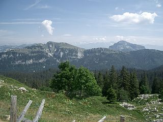
The Chartreuse Mountains are a mountain range in southeastern France, stretching from the city of Grenoble in the south to the Lac du Bourget in the north. They are part of the French Prealps, which continue as the Bauges to the north and the Vercors to the south.

The Vercors Massif is a range in France consisting of rugged plateaus and mountains straddling the départements of Isère and Drôme in the French Prealps. It lies west of the Dauphiné Alps, from which it is separated by the rivers Drac and Isère. The cliffs at the massif's eastern limit face the city of Grenoble.

The Jeita Grotto is a system of two separate, but interconnected, karstic limestone caves spanning an overall length of nearly 9 kilometres (5.6 mi). The caves are situated in the Nahr al-Kalb valley within the locality of Jeita, 18 kilometres (11 mi) north of the Lebanese capital Beirut. Though inhabited in prehistoric times, the lower cave was not rediscovered until 1836 by Reverend William Thomson; it can only be visited by boat since it channels an underground river that provides fresh drinking water to more than a million Lebanese.
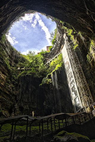
The Padirac Chasm is a cave located near Gramat, in the Lot department, Occitanie region, France.

The River Nidd is a tributary of the River Ouse in the English county of North Yorkshire. In its first few miles it is dammed three times to create Angram Reservoir, Scar House Reservoir and Gouthwaite Reservoir, which attract a total of around 150,000 visitors a year. The Nidd can overflow the reservoirs, flooding the caves in the valley. In such cases the river overflows into the normally dry river bed past Lofthouse through to Gouthwaite Reservoir. The Yorkshire Dales Rivers Trust YDRT has a remit to conserve the ecological condition of the River Nidd from its headwaters to the Humber estuary.

A pit cave, shaft cave or vertical cave—or often simply called a pit and pothole or pot ; jama in Slavic languages scientific and colloquial vocabulary —is a type of cave which contains one or more significant vertical shafts rather than being predominantly a conventional horizontal cave passage. Pits typically form in limestone as a result of long-term erosion by water. They can be open to the surface or found deep within horizontal caves. Among cavers, a pit is a vertical drop of any depth that cannot be negotiated safely without the use of ropes or ladders.
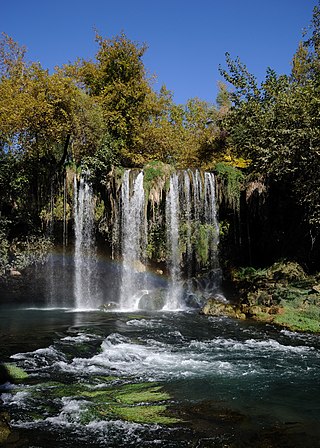
Düden Waterfalls are a group of waterfalls in the province of Antalya, Turkey. The waterfalls, formed by the recycle station water, are located 12 kilometres (7.5 mi) northeast of Antalya. They end where the waters of the Lower Düden Falls drop off a rocky cliff directly into the Mediterranean Sea.
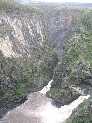
The Apsley Falls are two waterfalls on the Apsley River in the Northern Tablelands region of New South Wales, Australia. The falls are located about 20 kilometres (12 mi) east of Walcha, and 1 kilometre off the Oxley Highway in a deep gorge, that is part of the Oxley Wild Rivers National Park. They are the first falls in a succession of dramatic drops in an area that has some of the most remarkable scenery in Eastern Australia. The first drop of the falls is about 65 metres (213 ft) in depth, and the second, which is about 800 metres (2,625 ft) further on, plummets 58 metres (190 ft) to the bottom of the gorge.
The Gouffre Berger is a cave in the French alps within the commune of Engins high on the Vercors Plateau. It was discovered on 24 May 1953 by Joseph Berger, Georges Bouvet, Ruiz de Arcaute and Marc Jouffrey. From 1953 to 1963, it was regarded as the deepest cave in the world at −1,122 metres (−3,681 ft), relinquishing this title to the previous contender, Pierre Saint Martin, in 1964, after further exploration. The Gouffre Berger is now ranked 39th deepest cave in the world, and the 4th in France.

Leck Fell is a Site of Special Scientific Interest in Lancashire, England. An area of typically heavily grazed open moorland of rough grass and remnant patches of heather with little or no tree cover, it is characterised by the virtual absence of surface drainage and an extensive subterranean drainage network resulting in cave systems and numerous sinkholes. It surrounds the high point of Gragareth 627 metres (2,057 ft) between Leck Beck and Kingsdale.

The Dent de Crolles is a karstic mountain of the Chartreuse Mountains range, 17 kilometres north east of Grenoble, Isère, France. It has a characteristic "tooth-like" profile and is easily recognizable in the Isère Valley (Grésivaudan) in the Grenoble area. The French word "dent" means tooth and "de Crolles" is derived from the town of Crolles, located next to the mountain.

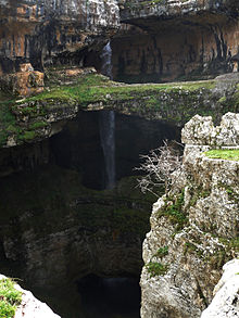
Tannourine is a Lebanese town located in the Batroun District, part of the Governorate of North Lebanon, 80 km from the capital Beirut. Tannourine is formed by a cluster of mountain settlements located in the highs of the Batroun District, the largest of which is Tannourine El-Fawqa, followed by Chatine,Tannourine El-Tahta, and Wata Houb. Tannourine has a population of approximately 25,000.

Anticosti National Park is a provincial park of Quebec, located in the Gulf of St. Lawrence. It consists of 3 non-contiguous areas totalling 572 square kilometres (221 sq mi) of land in the centre of Anticosti Island. Portions of the park are within Anticosti World Heritage Site, established by UNESCO in 2023.
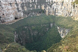
The Xiaozhai Tiankeng (小寨天坑), also known as the Xiaozhai Heavenly Pit, is the world's deepest sinkhole and also the largest in the Shaanxi cluster. It is located in Fengjie County of Chongqing Municipality in China.

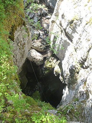
Death's Head Hole is a cave on Leck Fell, in Lancashire, England. Its entrance is a 64-metre (210 ft) deep shaft. It leads into Lost Johns' Cave and is part of the Three Counties System, an 87-kilometre (54 mi) cave system which spans the borders of Cumbria, Lancashire, and North Yorkshire.

ʻEua National Park is a national park on the island of ʻEua in Tonga. It is the country's only national forest park and covers an area of 4.51 km2 (2 sq mi). The park is located on the east coast of the island and covers an 800 metres (2,625 ft) band of tropical rainforest and is bordered on the west by sheer cliffs to the ocean, which have numerous caves and chasms. It received national park status in 1992. The area is protected by IUCN.

The Gouffre de la Pierre Saint-Martin, also called Gouffre Lépineux, is the original entrance to a major cave system located in the massif of La Pierre Saint-Martin, in the immediate vicinity of the Franco-Spanish border and the French commune of Arette, in the Pyrénées-Atlantiques in the Nouvelle-Aquitaine region, under which lies part of the cave network.