
A beach is a landform alongside a body of water which consists of loose particles. The particles composing a beach are typically made from rock, such as sand, gravel, shingle, pebbles, etc., or biological sources, such as mollusc shells or coralline algae. Sediments settle in different densities and structures, depending on the local wave action and weather, creating different textures, colors and gradients or layers of material.

A natural arch, natural bridge, or rock arch is a natural landform where an arch has formed with an opening underneath. Natural arches commonly form where inland cliffs, coastal cliffs, fins or stacks are subject to erosion from the sea, rivers or weathering.
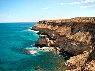
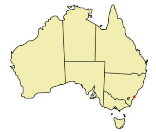
Kalbarri National Park is located 485 kilometres (301 mi) north of Perth, in the Mid West region of Western Australia.

The Jurassic Coast is a World Heritage Site on the English Channel coast of southern England. It stretches from Exmouth in East Devon to Studland Bay in Dorset, a distance of about 96 miles (154 km), and was inscribed on the World Heritage List in mid-December 2001.

Chesil Beach in Dorset, England is one of three major shingle beach structures in Britain. Its name is derived from the word chessil, meaning "gravel" or "shingle". It runs for a length of 29 kilometres (18 mi) from West Bay to the Isle of Portland and in places is up to 15 metres (50 ft) high and 200 metres (660 ft) wide. Behind the beach is the Fleet, a shallow tidal lagoon. Both are part of the Jurassic Coast and a UNESCO World Heritage Site, and together form an SSSI and Ramsar Site. Owners of the land designated as Chesil & The Fleet SSSI include the Crown Estate, the Ministry of Defence and the National Trust.
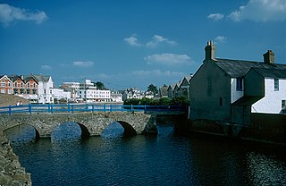
Bude is a seaside town in north Cornwall, England, United Kingdom, in the civil parish of Bude-Stratton and at the mouth of the River Neet. It was sometimes formerly known as Bude Haven. It lies southwest of Stratton, south of Flexbury and Poughill, and north of Widemouth Bay, located along the A3073 road off the A39. Bude is twinned with Ergué-Gabéric in Brittany, France. Bude's coast faces Bude Bay in the Celtic Sea, part of the Atlantic Ocean. At the 2021 census, the built-up area of the town had a population of 7,342. The population of the civil parish can be found under Bude-Stratton.

Comino is a small island of the Maltese archipelago between the islands of Malta and Gozo in the Mediterranean Sea, measuring 3.5 square kilometres (1.4 sq mi) in area. Named after the cumin seed, the island has a permanent population of only two residents and is part of the municipality of Għajnsielem, in southeastern Gozo, from where one priest and one policeman commute. The island is a bird sanctuary and nature reserve.

Porthcurno is a small village covering a small valley and beach on the south coast of Cornwall, England in the United Kingdom. It is the main settlement in a civil and an ecclesiastical parish, both named St Levan, which comprise Porthcurno, diminutive St Levan itself, Trethewey and Treen.

Ċirkewwa is a harbour and zone situated at the northernmost point of Malta, part of the locality of Mellieħa.

Penyal d'Ifac Natural Park is a natural park situated in Calpe, in the Valencian Community, Spain.
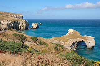
Tunnel Beach is a locality 7.5 kilometres (4.7 mi) southwest of the city centre of Dunedin, New Zealand. Located just south of St Clair, Tunnel Beach has sea-carved sandstone cliffs, rock arches and caves. Beyond the beauty of the rugged sandstone cliffs, its claim to fame is the tunnel down to the beach that a local politician, John Cargill, son of Captain William Cargill, had commissioned for his family in the 1870s. Local legend says that one or more of Cargill's daughters drowned while swimming at the beach, but there is no truth to this story.

The Azure Window, also known as the Dwejra Window, was a 28-metre-tall (92 ft) natural arch on the island of Gozo, located just off the shores of Malta. The limestone feature, which was in Dwejra Bay close to the Inland Sea and Fungus Rock, was one of the island's major tourist attractions until it collapsed in stormy weather on 8 March 2017. The arch, together with other natural features in the area, has appeared in a number of international films and media productions.
The city of Wollongong has a distinct geography. It lies on a narrow coastal plain flanked by the Pacific Ocean to the east and a steep sandstone precipice known as the Illawarra Escarpment to the west, most notably Mount Keira, joined to the escarpment by a high saddle.

Gozo, in antiquity known as Gaulos, is an island in the Maltese archipelago in the Mediterranean Sea. The island is part of the Republic of Malta. After the island of Malta itself, it is the second-largest island in the archipelago.

Tourism in Malta is an important sector of the country's economy, contributing to about 15 percent of the nation's gross domestic product (GDP). It is overseen by the Malta Tourism Authority, in turn falls under the responsibility of the Minister for Tourism, the Environment and Culture. Malta features a number of tourism attractions encompassing elements of the island's rich history and culture, as well as aquatic activities associated with the Mediterranean Sea. In addition, medical tourism has become popular in Malta in recent years, especially since government efforts to market the practice to medical tourists in the United Kingdom.
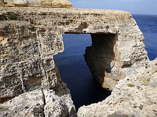
The Wied il-Mielaħ Window is a limestone natural arch on the north-western coast of the island of Gozo in Malta. It is located at the end of the valley Wied il-Mielaħ north of the village of Għarb. This natural arch is less well-known than the Azure Window, which collapsed in March 2017 following a heavy storm.

Għar Qawqla is a limestone formation located off Marsalforn on the island of Gozo in Malta. It was formerly a natural arch connected to the mainland, but the span collapsed at some point during the 20th century. It has been speculated that the name Marsalforn might be partially derived from forna, referring to the natural sea caves of the area, of which Għar Qawqla was one of the best-known. The formations stands about 7.9 metres (26 ft) off the shore.

Recreational dive sites are specific places that recreational scuba divers go to enjoy the underwater environment or for training purposes. They include technical diving sites beyond the range generally accepted for recreational diving. In this context all diving done for recreational purposes is included. Professional diving tends to be done where the job is, and with the exception of diver training and leading groups of recreational divers, does not generally occur at specific sites chosen for their easy access, pleasant conditions or interesting features.
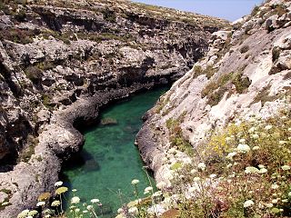
Għasri Valley is a sea canyon on the Maltese island of Gozo. The gorge continues on the land towards the village of Għasri. The valley is known for its quiet beach, which is 300 metres (980 ft) inland from the sea. The sea is only accessible via a narrow cove with high cliffs on both sides. On the edge of the valley, next to an underwater cave, it is commonly believed that Maltese salt pans were built and maintained. It contains a secluded beach which is popular with tourists and divers alike.

The geographyof Gozo, is dominated by water as it is the second largest island in the Maltese archipelago and is made up out of limestone. There are several islands which fall under Gozitan jurisdiction and thus are additions to the overarching Maltese archipelago. The main island of Gozo is located 7 kilometres (4.3 mi) northwest of the main island of Malta. It is mostly known for its multitude of low-lying hills. The highest point in Gozo is Ta' Dbiegi hill, which falls under the San Lawrenz local council. The island of Comino, which is also the third largest island in Malta, falls under Gozo.
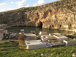
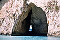 Connection between the Inland Sea and the open Mediterranean in February, 2007