Puerto Galera

Last updated

Puerto Galera
Municipality of Puerto Galera
Sabang Bay.jpg
Sabang Bay
Flag of Puerto Galera, Oriental Mindoro.png
Puerto Galera Oriental Mindoro.png
Motto: 
The Amazing Puerto Galera
Anthem: The Amazing Puerto Galera
Ph locator oriental mindoro puerto galera.png
Map of Oriental Mindoro with Puerto Galera highlighted
OpenStreetMap
Puerto Galera
Philippines location map (square).svg
Red pog.svg
Puerto Galera
Location within the Philippines
Coordinates: 13°30′00″N120°57′15″E / 13.5°N 120.95417°E / 13.5; 120.95417
Country Philippines
Region Mimaropa
Province Oriental Mindoro
District 1st district
Founded 1574
Barangays 13 (see Barangays)
Government
[1]
  Type Sangguniang Bayan
   Mayor Rocky D. Ilagan
   Vice Mayor Marlon L. Lopez
   Representative Paulino Salvador C. Leachon
   Electorate 27,759 voters (2022)
Area
[2]
  Total247.85 km2 (95.70 sq mi)
Elevation
429 m (1,407 ft)
Highest elevation
2,571 m (8,435 ft)
Lowest elevation
0 m (0 ft)
Population
 (2020 census) [3]
  Total41,961
  Density170/km2 (440/sq mi)
   Households
9,944
Economy
   Income class 1st municipal income class
   Poverty incidence
13.25
% (2018) [4]
   Revenue 217 million (2020)
   Assets 547.7 million (2020)
   Expenditure 209.5 million (2020)
   Liabilities 122.7 million (2020)
Service provider
  ElectricityOriental Mindoro Electric Cooperative (ORMECO)
Time zone UTC+8 (PST)
ZIP code
5203
PSGC
IDD : area code +63(0)43
Native languages Iraya
Tagalog
Website www.puertogalera.gov.ph

Puerto Galera, officially the Municipality of Puerto Galera (Tagalog : Bayan ng Puerto Galera), is a 1st class municipality in the province of Oriental Mindoro, Philippines. According to the 2020 census, it has a population of 41,961 people. [3]

Contents

It is mainly accessible from the Southern Luzon gateway port of Batangas by bamboo boats (bangka) operated by local regular operators. Seaplane Operator Air Juan Aviation, Inc. flies two daily flights from Manila to Puerto Galera on their Cessna Grand Caravan Seaplanes.

History

San Miguel (Spanish galera) replica at the Municipal Hall San Miguel (Spanish galera) replica, Puerto Galera, Oriental Mindoro, April 2023.jpg
San Miguel (Spanish galera) replica at the Municipal Hall

Chinese traders possibly knew the place before the arrival of the Spaniards but there is no evidence of Chinese settlement. [5] The place was likely also known by other Southeast Asian merchants, who would have found it convenient to load and unload trading goods. The state of Ma-i extended to the Puerto Galera area. The bay was a convenient place to shelter ships against bad weather, and a warehouse was built to store supplies and trade black rice from Muelle. [6]

In April 1570, the Spaniards arrived in Bombon (now known as Batangas), and later sailed through the Isla Verde Passage, landed and called the place Puerto Galera (the port of Galleons). Miguel López de Legazpi became the first Spanish governor-general of the island. A garrison for soldiers was built in Muelle, and watch towers were erected in Dampalitan Point to monitor naval activity in the bay. Spaniards came to conquer for their king and chased the Muslim Moro pirates who were disrupting their trade with the Chinese and natives. The latter proved to be not only skilled warriors but also good negotiators even in the face of defeat. [5]

In 1663, a change in the form of administration occurred in the island, the corregidor was replaced by the alcalde-mayor or provincial governor, and the capital was moved from Puerto Galera to Baco. In the seventeenth century, the relative prosperity of the city underwent a serious setback with the rise of Muslim piracy. [7] Both pirates attacks and the mismanagement of the Spaniards resulted in driving the native population either into exile in safer places or sending them inland to comparative safety.
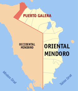
Geography

Puerto Galera is located at the north-westernmost part of Oriental Mindoro, and at the south-western end of the Isla Verde Passage, about 130 kilometres (81 mi) south of Manila and 51 kilometres (32 mi) from Calapan, the provincial capital.

Barangays

Puerto Galera is politically subdivided into 13 barangays. Each barangay consists of puroks and some have sitios.

  • Aninuan
  • Baclayan
  • Balatero
  • Dulangan
  • Palangan
  • Poblacion
  • Sabang
  • San Antonio
  • San Isidro
  • Santo Niño
  • Sinandigan
  • Tabinay
  • Villaflor

Climate

Climate data for Puerto Galera, Oriental Mindoro
MonthJanFebMarAprMayJunJulAugSepOctNovDecYear
Mean daily maximum °C (°F)28
(82)
29
(84)
30
(86)
31
(88)
31
(88)
30
(86)
29
(84)
29
(84)
29
(84)
29
(84)
29
(84)
28
(82)
29
(85)
Mean daily minimum °C (°F)22
(72)
21
(70)
22
(72)
23
(73)
25
(77)
25
(77)
25
(77)
25
(77)
25
(77)
24
(75)
23
(73)
22
(72)
24
(74)
Average precipitation mm (inches)48
(1.9)
32
(1.3)
41
(1.6)
54
(2.1)
257
(10.1)
410
(16.1)
466
(18.3)
422
(16.6)
429
(16.9)
300
(11.8)
137
(5.4)
92
(3.6)
2,688
(105.7)
Average rainy days10.88.09.811.723.127.529.228.728.725.518.212.8234
Source: Meteoblue (modeled/calculated data, not measured locally) [8]

Demographics

Population census of Puerto Galera
YearPop.±% p.a.
1903 1,275    
1939 3,433+2.79%
1948 3,948+1.57%
1960 5,925+3.44%
1970 7,659+2.60%
1975 10,129+5.77%
1980 12,306+3.97%
YearPop.±% p.a.
1990 17,200+3.41%
1995 19,485+2.36%
2000 21,925+2.56%
2007 28,035+3.45%
2010 32,521+5.55%
2015 36,606+2.28%
2020 41,961+2.72%
Source: Philippine Statistics Authority [9] [10] [11] [12]

The Philippine Statistics Authority characterizes the municipality of Puerto Galera as first class based on household income. [13] The municipality had a population of 32,521 in the 2010 national census. The population in 2012 was estimated to be 35,188. [14]

Economy

Port of Puerto Galera Port of Puerto Galera, Oriental Mindoro, April 2023.jpg
Port of Puerto Galera

The traditional economy of the city used to be fishing and subsistence agriculture, but with the boom of tourism at the end of the 1970s, the service sector became more and more important and led to population and economic growth. [22] Of the 13 villages ("barangays") in Puerto Galera, half now rely on tourism-based activities for sustenance. [23]

In addition, Mindoro is quickly becoming one of the key places in the development of renewable energy in the Philippines. With several large wind, hydroelectric, and geothermal projects under construction, the island hoped in 2012 to be a net exporter of electricity by 2016. [24] [25]

Tourism

White Beach PH - Puerto Galera - White Beach 2.jpg
White Beach

Tourism now represents the core activity of the economy of Puerto Galera, which is well known for its beaches, scuba diving and entertainment activities, including "go-go bars". The city and its beaches have also become one of the many sites of the Philippines sex tourism industry. [26]

This coastal town has a number of pocket beaches and snorkeling and scuba diving spots. The area was designated a Man and Biosphere reserve of UNESCO in 1973 and has some of the most diverse coral reef diving in Asia. Since 2001, the marine environment has benefited from a huge reduction in the number of fishermen in the area, as they gain higher revenue from tourism activities.

Puerto Galera is included in the list of the "Club of the Most Beautiful Bays of the World", and is the only bay in the Philippines to be found on this list. [27]

Among the beaches in Puerto Galera are Sabang Beach and White Beach, which have an active nightlife with numerous bars and restaurants. Both places are directly accessible from Batangas by bangka regular lines. On the west, where is only a local boat connection to Abra de Ilog, the planned road between the two cities has not been completed yet. On the east, the city connects by road to Calapan through the Mindoro circular road.

Tourism

Diving and snorkeling

Puerto Galera underwater view Puerto Galera underwater (4).jpg
Puerto Galera underwater view

Puerto Galera, especially the Sabang area, is among the top diving destinations in the Philippines and in Asia.[ citation needed ] Diving sites are found less than five minutes from Sabang Beach.[ citation needed ] Diving activities generally focus around the areas either side of Escarceo Point. Marine life is diverse. There are over 180+ species of nudibranchs found in the area, and many species of fish can be seen. A variety of wrecks over the years can be found in addition to the one wreck of an engine of a WWII Japanese patrol boat. The major diving federations PADI, CMAS, NAUI and Technical Diving International (TDI) are represented in the area, offering courses from beginners' open water to advanced and technical diving (rebreather, trimix). Diving trips in the Verde Island Passage, at the heart of the Coral Triangle are organized from Puerto Galera. Many threatened species such as a variety of sea turtles including hawksbills, olive ridleys, and green turtles, humphead wrasses, giant groupers and giant clams are present in the Verde Island Passage.

Environment

The accelerated development of tourism jeopardizes the preservation of its delicate ecological system consumed by "overdevelopment due to a thriving but runaway free-market tourism". [28] Currently, this appears to be the "biggest problem" of Puerto Galera. [29] Accelerated tourist oriented development poses degradation to the environment, among which, seawater pollution brought about by improper sewage and wastewater discharges. [23] Unless serious action is taken, with regular seawater monitoring, this situation poses a serious threat to the sustainability of various tourist activities at the beaches.

In the summer of 1998, extensive coral bleaching occurred around Medio Island, and a large section of a shallow coral reef system (referred to as the "Coral Gardens") died. Since then, the coral has regrown with a larger diversity of coral species replacing the prolific table corals. Corals in Puerto Galera were largely unaffected by the 2010 El Niño event. The local government declared the 4,828 ha of municipal waters (12,690 ha) as protected waters, giving special protection to the corals and reef fishes. [30]

In 2006, two super typhoons damaged the shallow reefs around Escarceo Point. A major section of the faster-growing coral species growing up to a depth of 6 metres (20 ft) was destroyed. This represented about 5% of the coral reef in the area. Extensive signs of new coral recruitment were noted in mid-2008. Acropora species (staghorn and table coral) rapidly recolonized the area so that most of the damaged coral has been replaced with new growth.

Related Research Articles

<span class="mw-page-title-main">Oriental Mindoro</span> Province in Mimaropa, Philippines

Oriental Mindoro, officially the Province of Oriental Mindoro, is a province in the Philippines located on the island of Mindoro under Mimaropa region in Luzon, about 140 kilometres (87 mi) southwest of Manila. The province is bordered by the Verde Island Passage and the rest of Batangas to the north, by Marinduque, Maestre de Campo Island, Tablas Strait and the rest of Romblon to the east, by Semirara and the rest of Caluya Islands, Antique to the south, and by Occidental Mindoro to the west. Calapan, the only city in the island, is the provincial capital and Mimaropa's regional center.

<span class="mw-page-title-main">Mimaropa</span> Administrative region of the Philippines

Mimaropa, officially the Southwestern Tagalog Region, is an administrative region in the Philippines. It is one of two regions in the country having no land border with another region. The name is an acronym combination of its constituent provinces: Mindoro, Marinduque, Romblon and Palawan.

<span class="mw-page-title-main">Mansalay</span> Municipality in Oriental Mindoro, Philippines

Mansalay, officially the Municipality of Mansalay, is a 2nd class municipality in the province of Oriental Mindoro, Philippines. According to the 2020 census, it has a population of 59,114 people.

<span class="mw-page-title-main">Coron, Palawan</span> Municipality in Palawan, Philippines

Coron, officially the Municipality of Coron, is a 1st class municipality in the province of Palawan, Philippines. According to the 2020 census, it has a population of 65,855 people.

<span class="mw-page-title-main">El Nido, Palawan</span> Municipality in Palawan, Philippines

El Nido, officially the Municipality of El Nido, is a 1st class municipality in the province of Palawan, Philippines. According to the 2020 census, it has a population of 50,494 people.

<span class="mw-page-title-main">Pinamalayan</span> Municipality in Oriental Mindoro, Philippines

Pinamalayan, officially the Municipality of Pinamalayan, is a 1st class municipality in the province of Oriental Mindoro, Philippines. According to the 2020 census, it has a population of 90,383 people.

<span class="mw-page-title-main">Dauin</span> Municipality in Negros Oriental, Philippines

Dauin, officially the Municipality of Dauin is a 4th class municipality in the province of Negros Oriental, Philippines. According to the 2020 census, it has a population of 30,018 people.

<span class="mw-page-title-main">Concepcion, Romblon</span> Municipality in Romblon, Philippines

Concepcion, officially the Municipality of Concepcion, is a 6th class municipality in the province of Romblon, Philippines. The municipality is coextensive with Maestre de Campo Island, which is also known as Sibale Island. According to the 2020 census, it has a population of 3,561 people.

<span class="mw-page-title-main">Ferrol, Romblon</span> Municipality in Romblon, Philippines

Ferrol, officially the Municipality of Ferrol, is a 6th class municipality in the province of Romblon, Philippines. According to the 2020 census, it has a population of 8,005 people.

<span class="mw-page-title-main">Lavezares</span> Municipality in Northern Samar, Philippines

Lavezares, officially the Municipality of Lavezares, is a 4th class municipality in the province of Northern Samar, Philippines. According to the 2020 census, it has a population of 29,390 people.

<span class="mw-page-title-main">Paluan</span> Municipality in Occidental Mindoro, Philippines

Paluan, officially the Municipality of Paluan, is a 3rd class municipality in the province of Occidental Mindoro, Philippines. According to the 2020 census, it has a population of 18,566 people.

<span class="mw-page-title-main">Rizal, Occidental Mindoro</span> Municipality in Occidental Mindoro, Philippines

Rizal, officially the Municipality of Rizal, is a 3rd class municipality in the province of Occidental Mindoro, Philippines. According to the 2020 census, it has a population of 40,429 people.

<span class="mw-page-title-main">Abra de Ilog</span> Municipality in Occidental Mindoro, Philippines

Abra de Ilog, officially the Municipality of Abra de Ilog, is a 2nd class municipality in the province of Occidental Mindoro, Philippines. According to the 2020 census, it has a population of 35,176 people.

<span class="mw-page-title-main">Sablayan</span> Municipality in Occidental Mindoro, Philippines

Sablayan, officially the Municipality of Sablayan, is a 1st class municipality in the province of Occidental Mindoro, Philippines. According to the 2020 census, it has a population of 92,598 people.

<span class="mw-page-title-main">Pola, Oriental Mindoro</span> Municipality in Oriental Mindoro, Philippines

Pola, officially the Municipality of Pola, is a 3rd class municipality in the province of Oriental Mindoro, Philippines. According to the 2020 census, it has a population of 35,455 people. It is 74 kilometres (46 mi) from Calapan.

<span class="mw-page-title-main">San Vicente, Palawan</span> Municipality in Palawan, Philippines

San Vicente, officially the Municipality of San Vicente, is a 1st class municipality in the province of Palawan, Philippines. According to the 2020 census, it has a population of 33,507 people.

<span class="mw-page-title-main">Baco, Oriental Mindoro</span> Municipality of the Philippines in the province of Oriental Mindoro

Baco, officially the Municipality of Baco, is a 3rd class municipality in the province of Oriental Mindoro, Philippines. According to the 2020 census, it has a population of 69,817 people.

<span class="mw-page-title-main">Bansud</span> Municipality in Oriental Mindoro, Philippines

Bansud, officially the Municipality of Bansud, is a 2nd class municipality in the province of Oriental Mindoro, Philippines. According to the 2020 census, it has a population of 42,671 people.

<span class="mw-page-title-main">Bulalacao</span> Municipality in Oriental Mindoro, Philippines

Bulalacao, officially the Municipality of Bulalacao, is a 3rd class municipality in the province of Oriental Mindoro, Philippines. According to the 2020 census, it has a population of 44,366 people.

<span class="mw-page-title-main">Calapan</span> Capital of Oriental Mindoro, Philippines

Calapan, officially the City of Calapan, is a 3rd class component city in the province of Oriental Mindoro, Philippines. According to the 2020 census, it has a population of 145,786 people. The city is the capital of the province of Oriental Mindoro.

References

  1. Municipality of Puerto Galera | (DILG)
  2. "2015 Census of Population, Report No. 3 – Population, Land Area, and Population Density" (PDF). Philippine Statistics Authority. Quezon City, Philippines. August 2016. ISSN   0117-1453. Archived (PDF) from the original on May 25, 2021. Retrieved July 16, 2021.
  3. 1 2 Census of Population (2020). "Mimaropa". Total Population by Province, City, Municipality and Barangay. Philippine Statistics Authority . Retrieved July 8, 2021.
  4. "PSA Releases the 2018 Municipal and City Level Poverty Estimates". Philippine Statistics Authority. December 15, 2021. Retrieved January 22, 2022.
  5. 1 2 Lopez, Violeta B. (1974). "Culture Contact and Ethnogenesis in Mindoro up to the End of the Spanish Rule" (PDF). Asian Studies. 12 (1): 1–38.
  6. Kushwaha, U. K. S. (2016). Black Rice: Research, History and Development. Springer. p. 51. ISBN   978-3-319-30153-2.
  7. Barrantes, Vicente (1878). Guerras piráticas de Filipinas contra mindanaos y joloanos, corregidas é ilustradas por Don Vicente Barrantes. Biblioteca Hispano-Ultramarina (in Spanish). Madrid: Imprenta de Manuel G. Hernández via Biblioteca Digital de Castilla y León.
  8. "Puerto Galera: Average Temperatures and Rainfall". Meteoblue. Retrieved April 27, 2020.
  9. Census of Population (2015). "Region IV-B (Mimaropa)". Total Population by Province, City, Municipality and Barangay. Philippine Statistics Authority . Retrieved June 20, 2016.
  10. Census of Population and Housing (2010). "Region IV-B (Mimaropa)" (PDF). Total Population by Province, City, Municipality and Barangay. National Statistics Office . Retrieved June 29, 2016.
  11. Censuses of Population (1903–2007). "Region IV-B (Mimaropa)". Table 1. Population Enumerated in Various Censuses by Province/Highly Urbanized City: 1903 to 2007. National Statistics Office.{{cite encyclopedia}}: CS1 maint: numeric names: authors list (link)
  12. "Province of Oriental Mindoro". Municipality Population Data. Local Water Utilities Administration Research Division. Retrieved December 17, 2016.
  13. "Philippine Standard Geographic Code (PSGC)". Philippine Statistics Authority. Retrieved February 25, 2022.
  14. "Demographic Profile". Official Website of Oriental Mindoro. Archived from the original on February 2, 2017. Retrieved January 27, 2017.
  15. "Poverty incidence (PI):". Philippine Statistics Authority. Retrieved December 28, 2020.
  16. "Estimation of Local Poverty in the Philippines" (PDF). Philippine Statistics Authority. November 29, 2005.
  17. "2003 City and Municipal Level Poverty Estimates" (PDF). Philippine Statistics Authority. March 23, 2009.
  18. "City and Municipal Level Poverty Estimates; 2006 and 2009" (PDF). Philippine Statistics Authority. August 3, 2012.
  19. "2012 Municipal and City Level Poverty Estimates" (PDF). Philippine Statistics Authority. May 31, 2016.
  20. "Municipal and City Level Small Area Poverty Estimates; 2009, 2012 and 2015". Philippine Statistics Authority. July 10, 2019.
  21. "PSA Releases the 2018 Municipal and City Level Poverty Estimates". Philippine Statistics Authority. December 15, 2021. Retrieved January 22, 2022.
  22. "Puerto Galera". UNESCO. 2013. Retrieved January 27, 2017.
  23. 1 2 Rubio, Maria Cecilia D.; Nadaoka, Kazuo; Pokavanich, Tanuspong; Iizuka, Hiroyasu; Blanco, Ariel C.; Paringit, Enrico C. (2006). Complementarity of Sensor Based Measurements and Community Perception for Monitoring and Management of Seawater Quality (PDF). Paper presented at the Symposium on Infrastructure Development and the Environment 2006, December 7–8, 2006, SEAMEO-INNOTECH, University of the Philippines, Diliman, Quezon City, Philippines.
  24. Evora, Robert A. (August 20, 2012). "Mindoro Wind Farm Dwarfs Ilocos Plant". Manila Standard Today. Archived from the original on August 24, 2012.
  25. Flores, Alena Mae S. (September 23, 2013). "Mindoro Wind Farm Cleared". ManilaStandardToday.com. Archived from the original on October 15, 2013.
  26. Wiss, Rosemary (2013). "And Justice for All? International Anti-Trafficking Agendas and Local Consequences in a Philippines Sex Tourism Town". Australian Journal of Human Rights. 19 (1): 55–82. doi:10.1080/1323-238X.2013.11882117. S2CID   158752556 via Academia.edu.
  27. Membership in the France-based Club of the Most Beautiful Bays of the World (Club des Plus Belles Baies du Monde) is obtained by application. The club is chartered to list only one bay per sea in a given country "Charte du Club des Plus Belles Baies". Club des Plus Belles Baies (in French). Archived from the original on October 23, 2008. Retrieved November 21, 2008.. The club lists the Bay of Puerto Galera (Baie de Puerto Galera Archived December 11, 2008, at the Wayback Machine ) as being located at 13°3' NR, 120°75' in the E China Sea (southern) ("E Mer de Chine (sud)" in French).
  28. Fortes, Miguel D. (1997). Puerto Galera: A Lost Biosphere Reserve?. South-South Co-operation Programme for Environmentally Sound Socio-Economic Development in the Humid Tropics Working Papers, No. 18. UNESCO. page 2, abstract.
  29. Sembrano, Edgar Allan M. (April 10, 2016). "Puerto Galera: A Biosphere Reserve in Distress". Lifestyle.Inq. Retrieved February 25, 2022.
  30. WWF Matching Grant Sulu Sulawesi Seas Marine Ecoregion Program CA Number HFP-A-00-02-00028-00 – Annual Report (PDF) (Report). WWF and USAID. 2008. Retrieved January 28, 2017 via usaid.gov.