Calve Island

Last updated

Calve Island
Calve Island.jpg
Calve Island viewed from Tobermory Golf Course
Location
Argyll and Bute UK relief location map.jpg
Red pog.svg
Calve Island
Calve Island shown in Argyll and Bute
OS grid reference NM521546
Coordinates 56°37′N6°02′W / 56.62°N 6.04°W / 56.62; -6.04
Physical geography
Island group Mull
Area72 ha (180 acres)
Area rank171= [1]
Highest elevation20 m (66 ft)
Administration
Sovereign state United Kingdom
Country Scotland
Council area Argyll and Bute
Demographics
Population0
Lymphad3.svg
References [2] [3] [4]

Calve Island is an uninhabited low-lying island off the east coast of the Isle of Mull in Argyll and Bute on the west coast of Scotland. A whitewashed farmhouse with substantial outbuildings stands on the western shore, used as a summer residence. [5] The island is 1+14 miles (2 kilometres) in length, and 12 mile (800 metres) wide at its widest point. [6] Calve is owned by the Cotton family who make use of it in the summer months. [7]

Contents

Calve Island
Calve Island stands to the south-east of Tobermory Bay, off the eastern shore of the Isle of Mull.
Calve Island, viewed from Afon Park, Mull Calve Island, Mull - geograph.org.uk - 1322187.jpg
Calve Island, viewed from Afon Park, Mull

Tidal offshore islands

Calve is classed as a separate island from Mull, although at its south-western point there are extreme low tides that would allow land access to it, via the small tidal island of Cnap a' Chailbhe. [8] Between Mull and Calve runs the channel known as Dòirlinn a' Chailbhe. Calve provides some shelter for Tobermory Bay, helping to make it a safer anchorage. [3] At the north-west of Calve is another small tidal island called Eilean na Beithe.

Diving

The waters around Calve provide various popular diving sites, both on the rocky walls and reefs and at the wreck of the Pelican. [9] The sheer wall of submerged rock, over 44 metres in depth, at the north-eastern point of the island, was named 4th in a top ten of Scotland's 'Wall dives'. It was given top marks for depth, marine life, visibility and the rock wall itself. It was only the absence of dangerous tidal currents that kept it off top spot. [10]

Wrecks

There are three wreck sites close to the coast of Calve, all of them between Calve and Mull. The oldest and most substantial is the Pelican, a steel-built paddle steamer built in Cork in 1850 and used by Caledonian MacBrayne as a passenger ferry/liner. By 1895 she was in use as a Coal Hulk in Tobermory Harbour. In a storm in December 1895 she broke her moorings and was driven across Tobermory Bay and onto rocks on Calve. When the tide fell, she slipped off the rocks and sank in 20 metres of water. [11] At the south end of Dòirlinn a' Chailbhe lies the wreck of the Strathbeg, a motor fishing vessel which sank at mooring during a gale in May 1984. [12] A third wreck, a single-masted smack called Anna Bhan has been identified by divers, but there is no date or details of loss. [13]

In May 2009 the speedboat (RIB) 'Sooty' ran aground on the northern tip of Calve at 23:30, having left Tobermory shortly before, after an evening drinking at a local pub. It is thought that the boat was travelling at around twenty knots (40 km/h) at the point of impact, driving it a further 11 metres onto the rocky shore. Of the four men on board, one was thrown out of the boat onto the rocks and died of his injuries. It is thought that reckless speeds, insufficient attention to the GPS device, an absence of lookout and failure to prepare a passage plan were all resulting from and exacerbated by the influence of alcohol. [14]

Symbol of depopulation

In 1934 a pioneering kayak expedition was made by Alastair Dunnett and Seamus Adam around the Inner Hebrides, sending back their expedition reports to the Daily Record and Evening News. Amidst the depopulation and poverty of the islanders they found that Calve Island was farmed by a single extended family, and stayed to help with the harvest, meeting two sisters, Margaret and Janet McDonald, who were locally renowned as competitive rowers. Alistair Dunnett (who went on to become editor of The Scotsman) wrote of how Calve showed the Scottish island not as a beautiful barren waste. 'It was on the contrary, a rich land, if neglected; fertile in all but faith'. [15] Undertaking another such kayak expedition in 2018, the historian David Gange was disappointed to find that, unlike the signs of revival across so much of the Hebrides, Calve has no population and minimal agricultural activity. It stood for him as symbol of the fragility and lack of resilience in the current re-population of the Scottish Islands compared to the situation before the Clearances of the previous two centuries. [16]

Stamps

Local stamps were issued for Calve Island in 1984 bearing the image of a Basset Hound. The nearest GPO post box is at Tobermory, on mainland Mull. [17] [18]

Related Research Articles

<span class="mw-page-title-main">Outer Hebrides</span> Archipelago and council area off the west coast of mainland Scotland

The Outer Hebrides or Western Isles, sometimes known as the Long Isle or Long Island, is an island chain off the west coast of mainland Scotland. The islands are geographically coextensive with Comhairle nan Eilean Siar, one of the 32 unitary council areas of Scotland. They form part of the archipelago of the Hebrides, separated from the Scottish mainland and from the Inner Hebrides by the waters of the Minch, the Little Minch, and the Sea of the Hebrides.

<span class="mw-page-title-main">Inner Hebrides</span> Archipelago off the west coast of mainland Scotland

The Inner Hebrides is an archipelago off the west coast of mainland Scotland, to the south east of the Outer Hebrides. Together these two island chains form the Hebrides, which experience a mild oceanic climate. The Inner Hebrides comprise 35 inhabited islands as well as 44 uninhabited islands with an area greater than 30 hectares. Skye, Mull, and Islay are the three largest, and also have the highest populations. The main commercial activities are tourism, crofting, fishing and whisky distilling. In modern times the Inner Hebrides have formed part of two separate local government jurisdictions, one to the north and the other to the south. Together, the islands have an area of about 4,130 km2 (1,594 sq mi), and had a population of 18,948 in 2011. The population density is therefore about 4.6 inhabitants per square kilometre.

<span class="mw-page-title-main">Staffa</span> Island of the Inner Hebrides in Argyll and Bute, Scotland

Staffa is an island of the Inner Hebrides in Argyll and Bute, Scotland. The Vikings gave it this name as its columnar basalt reminded them of their houses, which were built from vertically placed tree-logs.

<span class="mw-page-title-main">Tobermory, Mull</span> Village on the Isle of Mull, Scotland

Tobermory is the capital of, and until 1973 the only burgh on, the Isle of Mull in the Scottish Inner Hebrides. It is located on the east coast of Mishnish, the most northerly part of the island, near the northern entrance of the Sound of Mull. The village was founded as a fishing port in 1788; its layout was based on the designs of Dumfriesshire engineer Thomas Telford. It has a current population of about 1,000. It is notable for appearing in the 2002–05 children's programme Balamory by the BBC.

<span class="mw-page-title-main">Isle of Mull</span> Island off the coast of Scotland

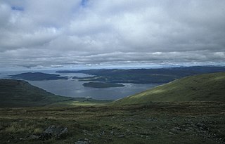
The Isle of Mull or just Mull is the second-largest island of the Inner Hebrides and lies off the west coast of Scotland in the council area of Argyll and Bute.

<span class="mw-page-title-main">Belnahua</span>

Belnahua is one of the Slate Islands, in the Firth of Lorn in Scotland, known for its deserted slate quarries. The bedrock that underpins its human history is part of the Scarba Conglomerate Formation and its value has been on record since the 16th century. Likely uninhabited before commercial quarrying commenced, under the control of the Stevenson family during the 19th century the population expanded to over 150 before the island was abandoned again in 1914.

The Treshnish Isles are an archipelago of small islands and skerries, lying west of the Isle of Mull, in Scotland. They are part of the Inner Hebrides. Trips to the Treshnish Isles operate from Ulva Ferry, Tobermory, Ardnamurchan and Tiree.

<span class="mw-page-title-main">Eilean Chathastail</span> Island in Scotland

Eilean Chathastail is one of the Small Isles in the Inner Hebrides of Scotland.

Gunna is an island in the Inner Hebrides of Scotland.

Hermetray is an uninhabited island off North Uist, in the Outer Hebrides of Scotland.

Stromay is a tidal island off North Uist in the Sound of Harris, Scotland.

<span class="mw-page-title-main">Eilean Ighe</span>

Eilean Ighe is a small tidal island near Arisaig in the Inner Hebrides of Scotland.

<span class="mw-page-title-main">Eilean Trodday</span>

Eilean Trodday is an island in The Minch just off the north coast of the Trotternish peninsula of Skye in Scotland.

The Torran Rocks are a group of small islands and skerries located between the islands of Mull and Colonsay in Scotland.

<span class="mw-page-title-main">Sound of Mull</span> Sound between the Inner Hebridean island of Mull and mainland Scotland

The Sound of Mull is a sound between the Inner Hebridean island of Mull and mainland Scotland. It forms part of the Atlantic Ocean.

The San Juan de Sicilia was one of the 130 ships that formed the ill-fated Spanish Armada of 1588. The ship was originally known as the Brod Martolosi, before it was seized to form part of the navy. It was one of 10 ships forming the Levant squadron, one of 8 squadrons that formed the entire armada.

<span class="mw-page-title-main">Loch na Keal</span> Sea loch in Argyll and Bute, Scotland

Loch na Keal, meaning Loch of the Kyle, or Narrows, also Loch of the Cliffs, is the principal sea loch on the western, or Atlantic coastline of the island of Mull, in the Inner Hebrides, Argyll and Bute, Scotland. Loch na Keal extends over 20 kilometres (12 mi) inland, almost bisecting Mull, and extending to within 5 km (3 mi) of the eastern shore. The loch gives its name to the Loch na Keal National Scenic Area, one of forty national scenic areas in Scotland.

<span class="mw-page-title-main">Risga</span> Uninhabited Scottish island

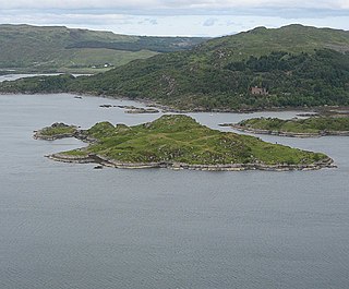
Risga is an uninhabited island in between Càrna and Oronsay, in the centre of Loch Sunart, about 800 yards (730 m) from the north shore, in the council area of Highland, Scotland. Its area is 12 hectares and its highest elevation is 43 metres (141 ft). In 1950, over 50 pairs of Lesser black-backed gull were recorded. The island is included in the grounds of Glenborrodale Castle and is part of Sunart SSSI. Ross Rock is located about 200 yards (180 m) from Risga. Risga has at least 60 crotagans along the east coast, used for fishing. Risga is a rocky island.

References

  1. Area and population ranks: there are c.300 islands over 20ha in extent and 93 permanently inhabited islands were listed in the 2011 census.
  2. General Register Office for Scotland (28 November 2003) Scotland's Census 2001 Occasional Paper No 10: Statistics for Inhabited Islands . Retrieved 26 February 2012.
  3. 1 2 Haswell-Smith (2004) p. 79
  4. Get-a-map (Map). Ordnance Survey.
  5. Haswell-Smith (2004) p.91
  6. Google Maps
  7. Haswell-Smith (2004) p. 91
  8. "Calve Island, Mull". scotilands.com. 2 January 2019. Retrieved 10 May 2020.
  9. dive site directory
  10. Mike Clark. "Scotlands Top Ten Wall Dives". divernet.com. Archived from the original on 23 February 2020. Retrieved 10 May 2020.
  11. "Pelican wreck, ID 102415". Canmore: Scottish National Record of the Historic Environment.
  12. "Strathbeg wreck, ID 937568". Canmore: Scottish National Record of the Historic Environment.
  13. "Anna Bhan wreck, ID 102561". Canmore: Scottish National Record of the Historic Environment.
  14. Marine Accident Investigation Branch, Southampton (2009). Report on the investigation of the grounding at high speed of the RIB Sooty: Calve Island, Isle of Mull, 18 May 2009 (PDF) (Report). Retrieved 10 May 2020.
  15. Alistair Dunnett, 1934, quoted in David Gange (2019). The Frayed Atlantic Edge. William Collins. p. 196. ISBN   978-0-00-822511-7.. A book on the 1934 expedition was republished as: Dunnett, Alastair (1995). The Canoe Boys: from the Clyde past the Cuillins. Glasgow: Neil Wilson. ISBN   1-897784-42-2.
  16. David Gange (2019). The Frayed Atlantic Edge. William Collins. p. 197. ISBN   978-0-00-822511-7.
  17. "Modern British Local Posts CD Catalogue, 2009 Edition". Phillips. 2003. Archived from the original on 5 September 2008. Retrieved 8 December 2008.
  18. "Basset Hound Stamps Archived 2008-12-07 at the Wayback Machine animalstamps.com. Retrieved 3 January 2009.

Bibliography

56°37′5″N6°2′26″W / 56.61806°N 6.04056°W / 56.61806; -6.04056