Glendalough is a glacial valley in County Wicklow, Ireland, renowned for an Early Medieval monastic settlement founded in the 6th century by St Kevin. From 1825 to 1957, the head of the Glendalough Valley was the site of a galena lead mine. Glendalough is also a recreational area for picnics, for walking along networks of maintained trails of varying difficulty, and also for rock-climbing.

Staffa from the Old Norse for stave or pillar island, is an island of the Inner Hebrides in Argyll and Bute, Scotland. The Vikings gave it this name as its columnar basalt reminded them of their houses, which were built from vertically placed tree-logs.

The Cobbler is a mountain of 884 metres (2,900 ft) height located near the head of Loch Long in Scotland. Although only a Corbett, it is "one of the most impressive summits in the Southern Highlands", and is also the most important site for rock climbing in the Southern Highlands. Many maps include the name Ben Arthur, but the name The Cobbler is more widely used.

Càrn Eige, sometimes spelt Càrn Eighe, is a mountain in the north of Scotland. At an elevation of 1,183 metres (3,881 ft) above sea level, it is the highest mountain in northern Scotland, the twelfth-highest summit above sea level in the British Isles, and, in terms of relative height, it is the second-tallest mountain in the British Isles after Ben Nevis. The highpoint of the historic county of Ross and Cromarty, it is the twin summit of the massif, being mirrored by the 1,181-metre (3,875 ft) Mam Sodhail, to the south on the same ridge.

Lugnaquilla, at 925 metres (3,035 ft), is the 11th–highest peak in Ireland on the Arderin list, and 13th–highest on the Vandeleur-Lynam list, and the highest Irish mountain outside of Kerry. Lugnaquilla is the highest point in Wicklow, and in the province of Leinster. Lugnaquilla is in the Wicklow Mountains, and overlooks the Glen of Imaal to the west and Glenmalure to the east.

Mweelrea at 814 metres (2,671 ft), is the 26th-highest peak in Ireland on the Arderin scale, and the 34th-highest peak on the Vandeleur-Lynam scale. Mweelrea is situated near the apex of a "horseshoe-shaped" massif that includes the peaks of Ben Lugmore and Ben Bury, and which is located between Killary Harbour and Doo Lough, in Mayo, Ireland. Mweelrea is the provincial top for Connacht, and is noted for its southeastern cliff lined corries, and its views. The massif is called the Mweelrea Mountains or the Mweelrea Range.

Scotland is the most mountainous country in the United Kingdom. The area north and west of the Highland Boundary Fault is known as the Highlands, and contains the country's main mountain ranges. Scotland's mountain ranges, in a rough north to south direction are: The Highlands & Islands, The Hills of the Central Lowlands, the Southern Uplands. The zone includes Britain's highest peaks, especially Ben Nevis, standing at 4,411.18 ft, with several similar peaks in the Cairngorms.
The Clisham is a mountain on Harris, on the island of Lewis and Harris in the Western Isles of Scotland. At 799 metres (2,621 ft) it is the highest mountain in the Outer Hebrides and the archipelago's only Corbett.

Camaderry at 699 metres (2,293 ft), is the 90th-highest peak in Ireland on the Arderin scale, and the 112th-highest peak on the Vandeleur-Lynam scale. Camaderry is situated in the southern sector of the Wicklow Mountains range, and forms a broad horseshoe around the valley of Glendalough with the hydroelectric station at Turlough Hill 681 metres (2,234 ft), and the mountains of Conavalla 734 metres (2,408 ft), and Lugduff 652 metres (2,139 ft). Camaderry has a subsidary summit of Camaderry South East Top 677 metres (2,221 ft), and both lie across the deep Wicklow Gap from Tonelagee 817 metres (2,680 ft), which sits on the "central spine" of the Wicklow Mountains range.
Cloghernagh at 800 metres (2,600 ft), does not have the prominence to qualify as an Arderin, but does have the prominence to be the 40th–highest peak on the Vandeleur-Lynam scale. Cloghernagh is situated in the southern sector of the Wicklow Mountains range, and is part of the large massif of Lugnaquilla 925 metres (3,035 ft), Wicklow's highest mountain.

Benleagh at 689 metres (2,260 ft), does not have the prominence to qualify as an Arderin, but its prominence does allow it to rank as the 125th–highest peak on the Vandeleur-Lynam scale. Benlagh is situated in the southern sector of the Wicklow Mountains, and is part of the large massif of Lugnaquilla 925 metres (3,035 ft), Wicklow's highest mountain.

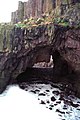
Eas na Dabhaich is a waterfall on the Isle of Mull in Scotland. The falls lie on a burn that flows from Loch Fraing on the Ross of Mull over high cliffs above Carsaig Bay. There are several more unnamed waterfalls above and along the 200 metres (660 ft) cliffs that stretch from east of Carsaig along to Malcolm's Point and the Carsaig Arches 5 kilometres (3.1 mi) to the west where they are called Aoineadh Mòr and beyond where the height is reduced to about 130 metres (430 ft) and they are known as Aoineadh Beag.

The Holy Trinity Monastery is an Eastern Orthodox monastery in central Greece, situated in the Peneas Valley northeast of the town of Kalambaka. It is situated at the top of a rocky precipice over 400 metres high and forms part of 24 monasteries which were originally built at Meteora, one of the oldest still existing of the Meteora monasteries. Six of the 24 monasteries are still active and open to visitors. The church was constructed between the fourteenth and fifteenth centuries and is included in the UNESCO list of World Heritage Sites titled Meteora.

Dùn da Ghaoithe is the second highest mountain on the Isle of Mull, western Scotland, and the island's only Corbett. It reaches 766 metres (2,513 ft) high, but "its long ridge and deep corries make it seem far higher". It boasts sea views "in almost every direction", and is the main mountain seen by visitors to the island on leaving the Caledonian MacBrayne ferry from Oban at Craignure.

Pennyghael is a small village in the Ross of Mull, Argyll and Bute, Scotland. It is located along the A849 road aligned along the coast line of Ross, on Loch Scridain in southwestern Mull, along the road to Bunessan. The Leidle River passes to the west of the village into the Loch.
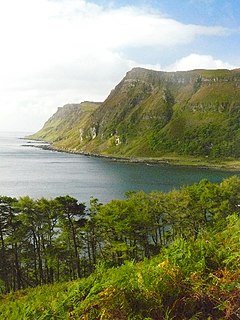
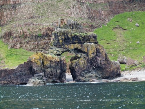
Carsaig Bay is a cove on the Ross of Mull in the south of the Isle of Mull, on the west coast of Scotland. It is situated 5 kilometres (3.1 mi) eastward of Rudha Fhaoilean, and 7 kilometres (4.3 mi) south of Pennyghael along a "narrow unclassified road". The bay is small and is surrounded by high, precipitous hills. It is unsafe for water craft, except in the part sheltered by the island of Gamhnach Mhòr, where small vessels can obtain anchorage. The northeastern part of Carsaig Bay is rocky and foul from 180–370 metres (590–1,210 ft) offshore from the eastern end of Gamhnach Mhòr to the head of the bay. Three of the rocks are marked by perches to facilitate the approach to Carsaig Quay. The tidal streams along the south coast of Mull are weak westward of Carsaig Bay.

Taksin Maharat National Park is a national park in Tak Province, Thailand. Home to Thailand's largest tree, the park also features waterfalls, caves, and rock formations.

Croaghanmoira at 664 metres (2,178 ft), is the 136th–highest peak in Ireland on the Arderin scale, and the 165th–highest peak on the Vandeleur-Lynam scale. Croaghanmoira is situated in the far south-east corner of the Wicklow Mountains range, and sits on its own small massif with several other lesser but well known peaks, separated from the nearby larger massif of Lugnaquilla by the Laragh to Aghavannagh road; the summit of Croaghanmoira has a distinctive "pyramidal" profile.

Ben Lugmore at 803 metres (2,635 ft), is the 29th-highest peak in Ireland on the Arderin scale, and the 37th-highest peak on the Vandeleur-Lynam scale. Ben Lugmore is situated in a "horseshoe-shaped" massif that includes the slightly higher peak of Mweelrea 814 metres (2,671 ft), the highest mountain in Connacht, which is located between Killary Harbour and Doo Lough, in Mayo, Ireland. Ben Lugmore is noted for its long summit ridge, that forms the deep cliff-lined headwall around the corrie of Lug More.