Staffa is an island of the Inner Hebrides in Argyll and Bute, Scotland. The Vikings gave it this name as its columnar basalt reminded them of their houses, which were built from vertically placed tree-logs.

The Isle of Mull or simply Mull is the second-largest island of the Inner Hebrides and lies off the west coast of Scotland in the council area of Argyll and Bute.

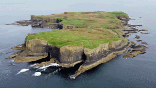
Ulva is a small island in the Inner Hebrides of Scotland, off the west coast of Mull. It is separated from Mull by a narrow strait, and connected to the neighbouring island of Gometra by a bridge. Much of the island is formed from Cenozoic basalt rocks, which are formed into columns in places.

Tongue is a coastal village in northwest Highland, Scotland, in the western part of the former county of Sutherland. It lies on the east shore above the base of the Kyle of Tongue and north of the mountains Ben Hope and Ben Loyal on the A836. To the north lies the area of Braetongue.
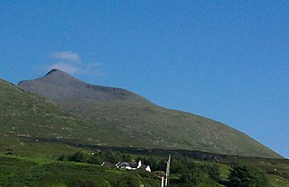
Ben More is the highest mountain and only Munro on the Isle of Mull, Scotland. It is also the highest peak in the Scottish isles – and the only Munro – apart from those on the Isle of Skye. The mountain is situated close to the centre of the island, above the shores of Loch na Keal.
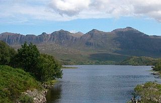
Quinag is an 808 m high mountain range in Sutherland in the Scottish Highlands, with an undulating series of peaks along its Y-shaped crest. The name Quinag is an anglicisation of the Gaelic name Cuinneag, a milk pail, reflecting its distinctive shape.

Freshwater West is a beach near Castlemartin, Pembrokeshire in West Wales. It lies along the B4319 road and is part of the Pembrokeshire Coast National Park. Freshwater West, noted for its strong waves and currents, is one of Wales' top surfing locations. The Castlemartin MOD firing range is located nearby.

Loch Scridain is a 15-kilometre-long (9-mile) sea loch, with a west-south west aspect, on the western, or Atlantic coastline of the Isle of Mull, in the Inner Hebrides, Argyll and Bute, Scotland.

The Unkar Group is a sequence of strata of Proterozoic age that are subdivided into five geologic formations and exposed within the Grand Canyon, Arizona, Southwestern United States. The Unkar Group is the basal formation of the Grand Canyon Supergroup. The Unkar is about 1,600 to 2,200 m thick and composed, in ascending order, of the Bass Formation, Hakatai Shale, Shinumo Quartzite, Dox Formation, and Cardenas Basalt. The Cardenas Basalt and Dox Formation are found mostly in the eastern region of Grand Canyon. The Shinumo Quartzite, Hakatai Shale, and Bass Formation are found in central Grand Canyon. The Unkar Group accumulated approximately between 1250 and 1104 Ma. In ascending order, the Unkar Group is overlain by the Nankoweap Formation, about 113 to 150 m thick; the Chuar Group, about 1,900 m (6,200 ft) thick; and the Sixtymile Formation, about 60 m (200 ft) thick. These are all of the units of the Grand Canyon Supergroup. The Unkar Group makes up approximately half of the thickness of the Grand Canyon Supergroup.

Bennane Head is a tapering piece of land formed of hard rock, projecting into the Firth of Clyde, in South Ayrshire, west of Scotland. At the northern end of Ballantrae Bay, 17 kilometres (11 mi) southwest of Girvan. A 200-metre-deep (660 ft) cave in the cliff under the headland is said to be the place where the cannibal Sawney Bean and his family lived in the 16th century.
The Dox Formation, also known as the Dox Sandstone, is a Mesoproterozoic rock formation that outcrops in the eastern Grand Canyon, Coconino County, Arizona. The Dox Formation comprises the bulk of the Unkar Group, the older subdivision of the Grand Canyon Supergroup. The Unkar Group is about 1,600 to 2,200 m thick and composed of, in ascending order, the Bass Formation, Hakatai Shale, Shinumo Quartzite, Dox Formation, and Cardenas Basalt. The Unkar Group is overlain in ascending order by the Nankoweap Formation, about 113 to 150 m thick; the Chuar Group, about 1,900 m (6,200 ft) thick; and the Sixtymile Formation, about 60 m (200 ft) thick. The entire Grand Canyon Supergroup overlies deeply eroded granites, gneisses, pegmatites, and schists that comprise Vishnu Basement Rocks.

Pennyghael is a small village in the Ross of Mull, Argyll and Bute, Scotland. It is located along the A849 road aligned along the coast line of Ross, on Loch Scridain in southwestern Mull, along the road to Bunessan. The Leidle River passes to the west of the village into the Loch.

Carsaig Arches are natural arch cliff formations on the Ross of Mull in the south of the Isle of Mull, on the west coast of Scotland. They are situated below Malcolm's Point, at the base of the Rudha Fhaoilean cliffs. To the east are Carsaig Bay, and Eas na Dabhaich.

Lurg Mhòr is a remote 986-metre (3,235 ft) mountain, a Munro, in the Northwest Highlands of Scotland at the high point of an east–west range of hills comprising Meall Mor, Lurg Mhòr and Bidein a' Choire Sheasgaich.
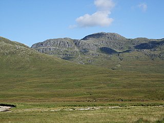
Bidein a' Choire Sheasgaich is a remote mountain in the Northwest Highlands of Scotland. It is a Munro with a height of 945 metres (3,100 ft) and is at the western end of an east–west ridge comprising a Munro Top Meall Mor, and the Munro Lurg Mhòr.

The Canadian Arctic Rift System is a major North American geological structure extending from the Labrador Sea in the southeast through Davis Strait, Baffin Bay and the Arctic Archipelago in the northwest. It consists of a series of interconnected rifts that formed during the Paleozoic, Mesozoic and Cenozoic eras. Extensional stresses along the entire length of the rift system have resulted in a variety of tectonic features, including grabens, half-grabens, basins and faults.

The geology of the Isle of Mull in Scotland is dominated by the development during the early Palaeogene period of a ‘volcanic central complex’ associated with the opening of the Atlantic Ocean. The bedrock of the larger part of the island is formed by basalt lava flows ascribed to the Mull Lava Group erupted onto a succession of Mesozoic sedimentary rocks during the Palaeocene epoch. Precambrian and Palaeozoic rocks occur at the island's margins. A number of distinct deposits and features such as raised beaches were formed during the Quaternary period.


