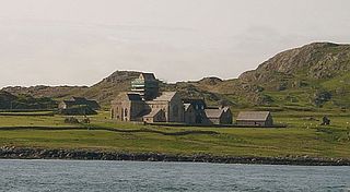
Iona is an island in the Inner Hebrides, off the Ross of Mull on the western coast of Scotland. It is mainly known for Iona Abbey, though there are other buildings on the island. Iona Abbey was a centre of Gaelic monasticism for three centuries and is today known for its relative tranquility and natural environment. It is a tourist destination and a place for spiritual retreats. Its modern Scottish Gaelic name means "Iona of (Saint) Columba".
Great Bernera, often known just as Bernera, is an island and community in the Outer Hebrides of Scotland. With an area of just over 21 square kilometres, it is the thirty-fourth largest Scottish island.
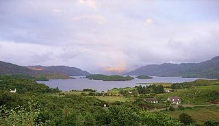
Loch Morar is a freshwater loch in the Rough Bounds of Lochaber, Highland, Scotland. It is the fifth-largest loch by surface area in Scotland, at 26.7 km2 (10.3 sq mi), and the deepest freshwater body in the British Isles with a maximum depth of 310 m (1,017 ft). The loch was created by glacial action around 10,000 years ago, and has a surface elevation of 9 metres (30 ft) above sea level. It separates the traditional district of North Morar, from Arisaig and Moidart.
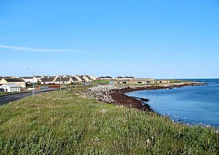
Balivanich is a village on the island of Benbecula in the Outer Hebrides off the west coast of Scotland. It is the main centre for Benbecula and the adjacent islands of North Uist, South Uist and several smaller islands. Balivanich is within the parish of South Uist.

Eileach an Naoimh is an uninhabited island in the Inner Hebrides of the west coast of Scotland. It is the second largest and southernmost of the Garvellachs archipelago and lies in the Firth of Lorn between Mull and Argyll. The name of the island is Gaelic for "rocky place of the saint" or from na-h-Eileacha Naomha meaning "the holy rocks".

Barvas is a settlement, community and civil parish on the Isle of Lewis in Scotland. It developed around a road junction. The A857 and A858 meet at the southern end of Barvas. North is the road to Ness; west takes the traveller to Carloway and the West Side; south runs the road to Stornoway. According to the 2011 Census it still had the highest concentration of Scottish Gaelic speakers in Scotland with 2,037. This fell to 55% in 2022.

Bragar is a village on the west side of the Isle of Lewis in the Outer Hebrides, Scotland, 14 miles from the island's only town, Stornoway. Bragar is within the parish of Barvas, and is situated on the A858 between Carloway and Barvas.

Carloway is a crofting township and a district on the west coast of the Isle of Lewis, in the Outer Hebrides, Scotland. The district has a population of around 500. Carloway township is within the parish of Uig, and is situated on the A858.

Little Bernera is a small island situated off the west coast of the Isle of Lewis in the Outer Hebrides.

Mealista was a township in the west of the Isle of Lewis. It is currently largely uninhabited due to the Highland Clearances, which occurred there in 1838. The beach is a visitor attraction.
Pabay Mòr or Pabaigh Mòr is an uninhabited island in the Outer Hebrides of Scotland.

Borve is a village on the west side of the Isle of Lewis in Scotland, 17 miles from the island's only town, Stornoway.
North Dell is a village on the Isle of Lewis in the community of Ness, in the Outer Hebrides, Scotland. North Dell is within the parish of Barvas. It lies 5 km south of the Butt of Lewis, between the settlements of South Dell and Cross and comprises 22 crofts. North Dell is reputed to be the best village for the growing of potatoes in Lewis – along with Garrabost in Point!

Swainbost is a village on the Isle of Lewis in the district of Ness, in the Outer Hebrides, Scotland. The name Swainbost meaning Sweins steading is of Viking derivation. The settlement is situated in the parish of Barvas. According to Ronald Black, Swainbost was re-settled during the Highland Clearances in 1842. The island's Anglo-Scottish landlord had expected the crofters evicted from Uig to emigrate and only reluctantly granted them land at Swainbost to avert the threat of violence.

Aird Uig is a village on the Isle of Lewis, in the Outer Hebrides, Scotland. Aird Uig is within the parish of Uig, and is situated on the C40 minor road which joins to the B8011 at Timsgarry. The township includes 700 hectares of common grazings to the east and west of the village.
Timsgarry is a village on the Isle of Lewis, in the Outer Hebrides, Scotland. Timsgarry is home to the Baile na Cille Church and the Uig Museum, noted for its giant Chessmen, discovered in the sands in 1831.
Páll, son of Bálki, or Paal Baalkeson, was a 13th-century Hebridean lord who was an ally of Olaf the Black, king of Mann and the Isles. He was long remembered in Gaelic tradition and is traditionally the progenitor of certain families with roots in the Hebrides. Páll is recorded as being a "sheriff" of Skye, a post which had earlier been held by another Páll, son of Bálki, who was possibly an ancestor. This earlier sheriff was said to have been a close friend of Godred II, King of Mann and the Isles.
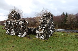
Snizort Cathedral was a small cathedral church located on an island in the River Snizort, near the head of Loch Snizort on the Scottish island of Skye. Also referred to as Church of St Columba or Skeabost, it was founded under the authority of the Archbishop of Nidaros (Trondheim) in Norway. Amongst its more famous bishops was Wimund, who according to William of Newburgh became a seafaring warlord adventurer in the years after 1147.

Lochs is a civil parish on the Isle of Lewis in the Western Isles, Scotland. It is one of the four civil parishes in Lewis and extends over the south-eastern part. It is bordered by the parish of Stornoway in the north and Uig in the west. Loch Seaforth separates it from Harris in the south, apart from a 19 miles land border with Harris. It extends about 19 miles north to south and 16 miles east-west. The Shiant Islands, about five miles (8.0 km) to the south-east, also belong to the parish. The parish is so-named because of the profusion of lochs, sea and fresh-water, in the area.

