Pacific Rim National Park Reserve is a 511 km2 (197 sq mi) national park located in British Columbia, Canada, which comprises three separate regions: Long Beach, the Broken Group Islands, and the West Coast Trail. It is located in the Pacific Coast Mountains, which are characterized by rugged coasts and temperate rainforests.

Bowen Island, British Columbia, is an island municipality that is part of Metro Vancouver, and within the jurisdiction of the Islands Trust. Located in Howe Sound, it is approximately 6 kilometres (3.7 mi) wide by 12 kilometres (7.5 mi) long, and at its closest point is about 3 kilometres (1.9 mi) west of the mainland. There is regular ferry service from Horseshoe Bay provided by BC Ferries, and semi-regular water taxi services. The population of 4,256 is supplemented in the summer by about 1,500 visitors. It has a land area of 50.12 km2 (19.35 sq mi).

West Vancouver is a district municipality in the province of British Columbia, Canada. A member municipality of the Metro Vancouver Regional District, West Vancouver is to the northwest of the city of Vancouver on the northern side of English Bay and the southeast shore of Howe Sound, and is adjoined by the District of North Vancouver to its east. Together with the District of North Vancouver and the City of North Vancouver, it is part of a local regional grouping referred to as the North Shore municipalities, or simply "the North Shore".

Gulf Islands National Park Reserve is a national park located on and around the Gulf Islands in British Columbia, Canada. In the National Parks System Plan, this park provides representation of the Strait of Georgia Lowlands natural region, the only place in Canada with a Mediterranean climate of dry, sunny summers and mild, wet winters, the result of a rain shadow effect from surrounding mountains between the region and the ocean. It has similar dominant vegetation as the Pacific Northwest, such as coastal Douglas-fir, western red cedar, shore pine, Pacific dogwood, bigleaf maple, and red alder, but also contains the northern extent of some of the more drought tolerant trees such as Garry oak and Arbutus. The park was created in 2003 as the fortieth national park. It covers 36 square kilometres (14 sq mi) of area on 16 islands and more than 30 islets, reefs and surrounding waters, making it the sixth smallest national park in Canada.
Highway 99 is a provincial highway in British Columbia that runs 377 kilometres (234 mi) from the U.S. border to near Cache Creek, serving Greater Vancouver and the Squamish–Lillooet corridor. It is a major north–south artery within Vancouver and connects the city to several suburbs as well as the U.S. border, where it continues south as Interstate 5. The central section of the route, also known as the Sea to Sky Highway, serves the communities of Squamish, Whistler, and Pemberton. Highway 99 continues through Lillooet and ends at a junction with Highway 97 near Cache Creek.

Garibaldi Provincial Park, also called Garibaldi Park, is a wilderness park located on the coastal mainland of British Columbia, Canada, 70 kilometres (43.5 mi) north of Vancouver. It was established in 1920 and named a Class A Provincial Park of British Columbia in 1927. The park is a popular destination for outdoor recreation, with over 30,000 overnight campers and over 106,000 day users in the 2017/2018 season.
Kitsilano Beach is one of the most popular beaches in Vancouver, especially in the warm summer months. Located at the north edge of the Kitsilano neighbourhood, the beach faces out onto English Bay.
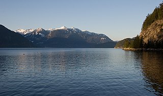
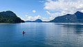
Howe Sound is a roughly triangular sound, that joins a network of fjords situated immediately northwest of Vancouver, British Columbia, Canada. It was designated as a UNESCO Biosphere Reserve in 2021.

The Tantalus Range is a subrange of the Pacific Ranges of the Coast Mountains in southern British Columbia, Canada. The range is easily viewed from the "Sea to Sky Highway" that travels from Vancouver to Squamish and Whistler. To Squamish people, the local indigenous people of the area, the name of the Tantalus Range is Tsewílx’.
Murrin Provincial Park is a provincial park in British Columbia, Canada, located just south of Squamish beside the Sea-to-Sky Highway. The park is approximately 24 ha. in size and has a popular highway-side picnic ground and small swimming lake, but it is most notable for a collection of petroglyphs located away from the highway and accessed by trail. Several rockfaces in the area of the park are popular with the local mountain-climbing community, though the site is nowhere as busy as the nearby Stawamus Chief.

Plumper Cove Marine Provincial Park is a provincial park in British Columbia, Canada. The park is located on Keats Island in Howe Sound, northwest of Vancouver, British Columbia.

Shannon Falls Provincial Park is a provincial park in British Columbia, Canada. It is located 58 kilometers (36 mi) from Vancouver and 2 kilometers (1.2 mi) south of Squamish along the Sea to Sky Highway.
Scouting in British Columbia has a long history, from the 1900s to the present day, serving thousands of youth in programs that suit the environment in which they live.

The Sea-to-Sky Corridor, often referred to as the Corridor or the Sea to Sky Country, is a region in British Columbia spreading from Horseshoe Bay through Whistler to the Pemberton Valley and sometimes beyond to include Birken and D'Arcy. From Whistler on up, the region overlaps with the older and more historic Lillooet Country, of which Squamish, at the region's centre, was once the southward extension in the days when it was the rail-port terminus from the Interior, via Lillooet, and accessible from the Lower Mainland only by sea. Most of the region is in the Squamish-Lillooet Regional District, although south of Britannia Beach a small part of the region is in the Greater Vancouver Regional District.
Gambier Island is an island located in Howe Sound near Vancouver, British Columbia. It is about 17,049 acres in size and is located about 10 kilometres north of the Horseshoe Bay community and ferry terminal in westernmost West Vancouver.

Valdes Island is one of the Gulf Islands located in the Strait of Georgia, British Columbia, Canada. It is across Porlier Pass from Galiano Island, which lies to the southeast. It has an area of 23 square kilometres, and is 1.6 kilometres wide by 16 kilometres in length. The island is popular with kayakers, boaters and has historically been the site of several human settlements.

Anvil Island is the third-largest of the islands in Howe Sound, British Columbia, Canada, and the northernmost of the major islands in that sound. It is part of West Howe Sound, Electoral Area F within the Sunshine Coast Regional District (SCRD) on the Sunshine Coast.
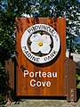
The Defence Islands are two small islands in Howe Sound, British Columbia, Canada, northeast of Anvil Island and in the northern reaches of that sound near Porteau Cove. The easterly and smaller of the two comprises Defence Island Indian Reserve No. 28 ; the westerly comprises the Kwum Kwum Indian Reserve, both under the administration of the Squamish Nation.

Portland Island is an island of the Southern Gulf Islands of the South Coast of British Columbia, Canada. It is located in the Salish Sea west of Moresby Island and off the south tip of Saltspring Island, adjacent to the main BC Ferries route just offshore from the terminal at Swartz Bay at the tip of the Saanich Peninsula. It was named after HMS Portland, the flagship of Rear-Admiral Fairfax Moresby, Commander in Chief of the Pacific Station 1850–1853.

The Howe Sound Crest Trail is a rugged 32.8-kilometre (20.4 mi) wilderness hiking trail located near Vancouver, British Columbia, Canada. The trail is located mostly within Cypress Provincial Park and is typically traveled as a single or multi-day hike from south to north, or as a means to access peaks along the route such as Mount Brunswick. It gets its name because it follows the crests of the North Shore Mountains that rise above the Howe Sound, the deep saltwater glacial fjord which parallels the trail to the west. It can be accessed in the south from Cypress Mountain Ski Area and in the north from the Sea to Sky Highway at Porteau Road, or via many intersecting trails that start at Lions Bay.